Passer au contenu principal
abebooks.fr
Chercher
Ouvrir une session
Votre compte
Panier
Aide
Menu
Votre compte
Vos commandes
Recherche avancée
Collections
Livres anciens
Art & Collection
Vendeurs
Devenir vendeur
Aide
Fermer
Maps
Proposé par
Independent Books
Plus populaires
Ajouts récents
Prix croissant
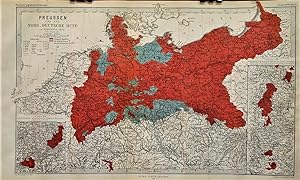
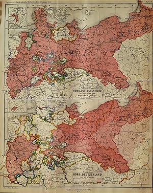
1866 Map of Prussia and the North German Confederation in September 1866. Designed by a. Peterman...
Berghaus, Hermann
1866
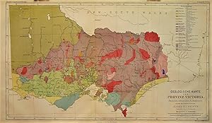
1865 Geological Map of Victoria Province after the Official Survey under the Direction of Alfred ...
Petermann, A.; Alfred R.C. Selwyn (director)
1865
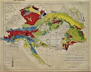
1863 Geological Overview Map of the Austrian Empire According to the Images of the k. k. Geologic...
Petermann, A.
1863
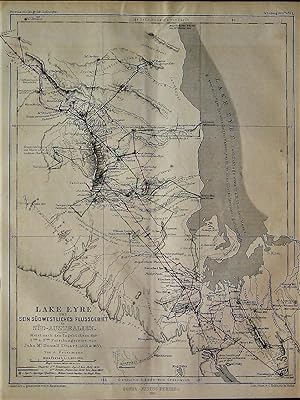
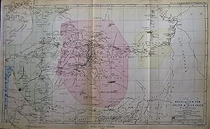
1863 Map of Lake Eyre and its Southwestern River Area in South Australia. Primarily based on the ...
Petermann, A.
1863
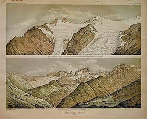
Two 1865 Aquatints and Two 1865 Maps of Adamello and the Adamello-Presanella Alps Region
Petermann, A.
1865
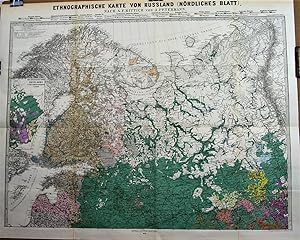
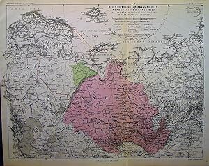
1878 Ethnographic Map of Russia after A.F. Rittich by A. Petermann. In two sheets.
Petermann, A.
1878
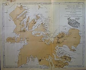
1875 Map of Kerguelen Island Primarily after Surveys by Kerguelen, Cook, Rhodes, Ross, Nares 1772...
Petermann, A.
1875
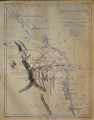
1865 Original Map of the Soturba Mountains or the Part of Nubia Known as Ammed Gorab by G. Schwei...
Petermann, A.
1865
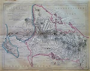
1863 Map of the Province of Chiriqui (State of Panama). After Handwritten Drawings & Surveys of C...
Petermann, A.
1863
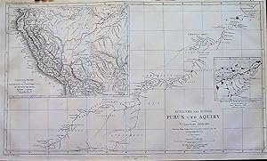
1867 Map of the Purus and Aquiry Rivers after Surveys by W. Chandless, 1864 & 1865. Based on the ...
Petermann, A.
1867
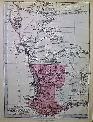
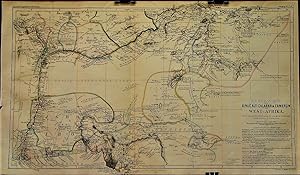
1875 Map of West Australia. By A. Petermann.
Petermann, A.
1875
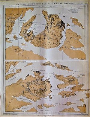
1863 Map of L. T. Reichel's Surveys of the Surroundings of Okak and Nain in Labrador
Petermann, A.
1863
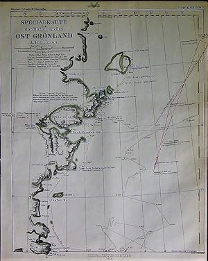
1868 Special Map of the Northern Part of East Greenland. By A. Petermann.
Petermann, A.
1868
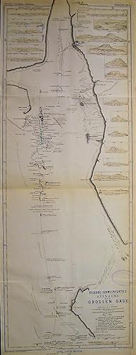
1875 Map of Dr. George Schweinfurth's Survey of the Great Oasis. With 20 insets.
Petermann, A.
1875
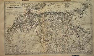
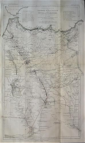
1866 Overview Map of the Travels of Gerhard Rohlfs in Morocco, Tuat, Tripoli, Fessen, etc., 1861-...
Petermann, A.
1866
1866 Maps of the North German Confederation in September 1866, and of North Germany 50 Years Prev...
Berghaus, Hermann
1866
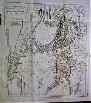
1868 Original Map Northwestern Part of the Argentine Republic (the Provinces of Tucuman & Catamar...
Petermann, A.
1868
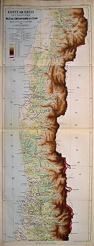
1875 Map of Chile in Two Parts (Northern and Southern). After the Land Survey Recorded at 1:250,0...
Petermann, A.
1875
1875 Original Map of Wadai and Darfur Lands in the Sudan. By Dr. G. Nachtigal.
Nachtigal, G.; A. Petermann
1875
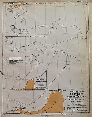
1875 Original Map of Ice Drift during the Austro-Hungarian Expedition under Weyprecht & Payer Aug...
Petermann, A.
1875
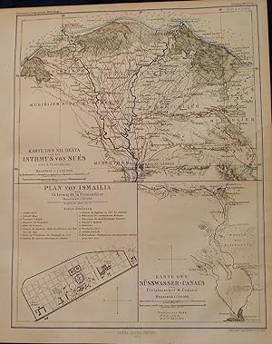
Three 1864 Maps of the Suez Region
Petermann, A.
1864
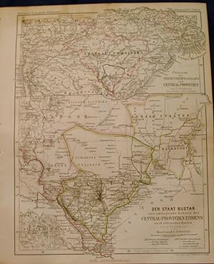
Two 1864 Maps of Central India and the Bastar Province
Petermann, A.
1864
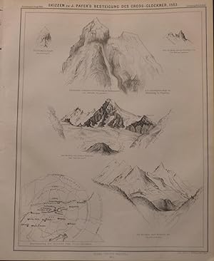
6 Sketches of Mountaineer Julius Payer’s Ascent of the Glossglockner
Petermann, A.
1864
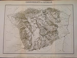
1864 Map of the Excursions of the Alpine Club
Petermann, A.
1864
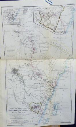
1864 Map of Kilimanjaro and Kenya in East Africa (and inset maps of Mombai and Usambara)
Petermann, A.
1864
1865 Original Map of Gerhard Rohlfs' Travels in Central and South Morocco (Atlas, Talfilet, Draa,...
Petermann, A.
1865
1863 Map of the River Basins of the Binue, Old Calabar & Cameroon in West Africa. With Special Co...
Petermann, A.
1863
1863 Original Map of Dr. O. Blue's Journey from Urmia Lake to the Van Lake, 1857
Petermann, A.
1863
1863 Map : Sketch of the Zab-Ala Area in Kurdistan by W. Strecker
Strecker, W.
1863
3 1866 Maps. Two Excerpts from C. Vogel's Topographical Map of the Thuringian Forest: One of Donn...
Petermann, A.
1866
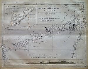
1866 Original Map of the Road between Berber and Suakin in Nubia. After the Surveys and the Manus...
Hassenstein, B.
1866
1866 Map of the Upper San Francisco River and the Upper Old River (Brazil). Inset Map Comparing t...
Petermann, A.
1866
1867 Map of the Distribution of Parrots in the World. 5 Small Maps on One Page of Night Parrots, ...
Petermann, A.
1867
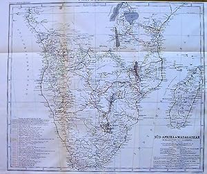
1867 Map of South Africa and Madagascar. By A. Petermann. Karl Mauch's Journey in the Interior of...
Petermann, A.
1867
1867 Map of Switzerland. Drawn by Hermann Berghaus.
Petermann, A.
1867
1868 Map of the Nile Headwaters and the Equatorial Lakes of Africa together with Routes of Travel...
Petermann, A.
1868
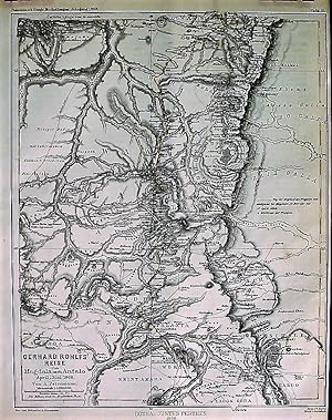
1868 Map of Gerhard Rohlf's Travel from Magdala to Antalya. April-May 1868. By A. Petermann.
Petermann, A.
1868
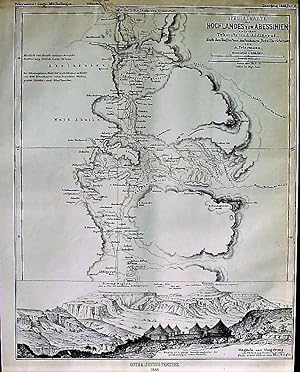
1868 Special Map of the Highlands of Abyssinia between Tekonda and Addigerat. After English Photo...
Petermann, A.
1868
1868 Original Map of Central Abyssinia. To a Large Extent According to Unpublished Documents. By ...
Petermann, A.
1868
1868 Map of the Lakes Basin of Balkhash and Ala-Kul in Inner Asia. According to the Latest Russia...
Petermann, A.
1868
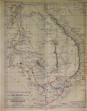
1868 Map of French Surveys of the Mekong, 1866-67 and Chart of the Geography of Indochina, Januar...
Petermann, A.
1868
1868 Map of the Rennstieg Trail of the Thuringian Forest and the Distribution of Mosses in Thurin...
Petermann, A.
1868
1875 Map of the Coal Fields of the United States of North America. Based on the Map of Hitchcock ...
Petermann, A.
1875
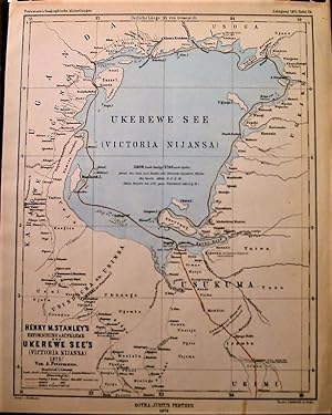
1875 Map of Henry M. Stanley's Exploration & Survey of the Ukerewe Lake (LakeVictoria) 1875. By A...
Petermann, A.
1875
1875 Original Map of the Areas of the Upper Nile, Overview of all the Routes Up to 1875. By A. Pe...
Petermann, A.
1875
1875 Original Map of G. Rohlf's Guided Expedition in the Libyan Desert 1873-1874. According to As...
Petermann, A.
1875
1875 Map of Lieutenant V.L. Cameron's Surveys of the Southern Part of Lake Tanganyika, 1874. Redu...
Petermann, A.
1875
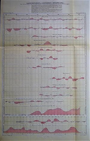
1875 Chart of Illustrations to Chavanne's Treatise on the Ice Conditions in the Polar Oceans, and...
Petermann, A.
1875
1875 Two Original Maps: C. Weyprecht's Bearings of the North Coast of Novaya Zemlya September & O...
Petermann, A.
1875
1875 Map of a New Sea Route from Europe to Siberia. The Nordenskjold Expedition from Tromso to Ye...
Petermann, A.
1875
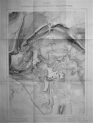
1875 Plan of the Royal Castle Wilhelmshohe in Kassel and its Surroundings.
Petermann, A.
1875
1876 Map of Territorial Relationships in Central India. New Boundary Changes. By A. Petermann. Wi...
Petermann, A.
1876
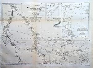
1876 and 1877 Two Special Maps of Middle Eastern Sudan Primarily Based on E. de Pruyssenaere's As...
Zoeppritz, K.
1876
1878 Series of 3 Maps Regarding World Rivers and Deltas: 1) Maps of Some Important Deltas in Orde...
Petermann, A.
1878
Three 1864 Maps of the Lakes of Southern Chile
Petermann, A.
1864
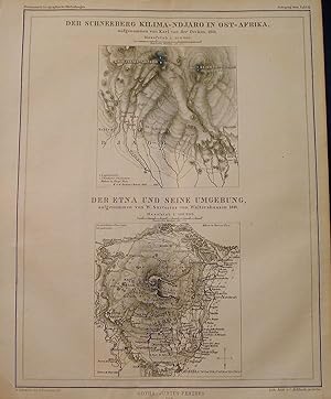
Two 1864 Maps of Mount Kilimanjaro and Mount Etna
Petermann, A.
1864
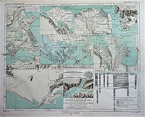
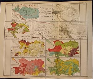
9 1864 Maps of the Physical and Statistical Characteristics of Austria
Petermann, A.
1864
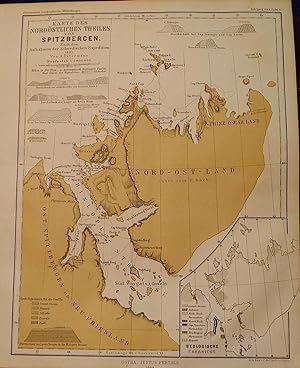
1864 Map of the Northeastern Part of Spitsbergen, Based on Accounts of the Swedish Expedition of ...
Petermann, A.
1864
Two 1864 Maps of Switzerland
Petermann, A.
1864
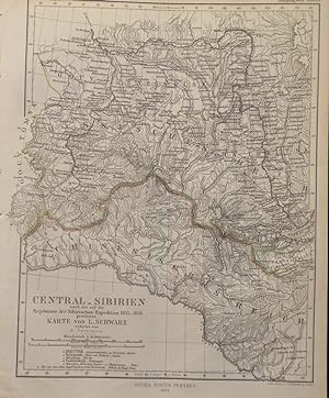
1864 Map of Central Siberia
L. Schwarz
1864
Plus de résultats