Montant total (1 article articles) :
Destination de la commande :

BOWEN, EMAN (52 résultats)
Passer aux résultats principaux de la recherche
Type d'article
- Tous les types d'articles
- Livres (13)
- Magazines & Périodiques
- Bandes dessinées
- Partitions de musique
- Art, Affiches et Gravures (1)
- Photographies
- Cartes (37)
-
Manuscrits &
Papiers anciens (1)
Etat
- Tous
- Neuf
- Ancien ou d'occasion
Reliure
Particularités
- Edition originale (3)
- Signé
- Jaquette
- Avec images (42)
- Sans impression ŕ la demande
Pays
Evaluation du vendeur
-
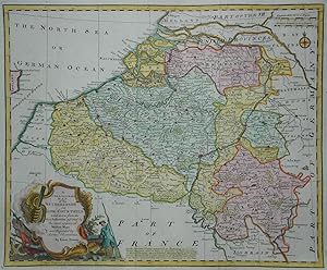
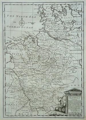
Germany Deutschland. A NEW ACCURATE MAP OF THE NORTH WEST PART OF GERMANY
Date d'édition : 1770
Vendeur : La Casa del Collezionista, Pistoia, PT, Italie
Evaluation du vendeur :

Germany Deutschland. A NEW ACCURATE MAP OF THE NORTH WEST PART OF GERMANY. Carta geografica con cartiglio figurato (con bevitori di birra). Tratta dall'atlante di Bowen, circa 1770. Misura cm 22,5x33 (ai margini cm 27,3x42,5). Ottima conservazione. (Rif.D6304).
-
An Accurate Map of the County of Suffolk (1750)
Edité par Unstated, 1111
Vendeur : World of Rare Books, Goring-by-Sea, SXW, Royaume-Uni
Evaluation du vendeur :
Etat : Good. Facsimile. Unpaginated. Colour cloth bound map with pictorial slipcase. Map has light tanning overall. Slipcase has light edge wear with minor markings to panels.
-

A new & correct map of the Netherlands or low countries.
Edité par For Mr Tindal 's continuation of Mr Rapin's history of England o J (um ), 1750
Größe ca. 50 x 40 cm. -Gefaltet, gebräunt, Randeinrisse. 1000 gr.
-
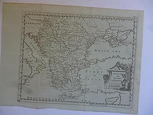
Hungary with Turkey in Europe
Date d'édition : 1794
Vendeur : Roger Collicott Books, Widecombe in the Moor, DEVON, Royaume-Uni
Evaluation du vendeur :

Carte
Map. Etat : Very Good. Uncoloured late 18th cent. map. Size : 230 x 180 mm. C 8.
-
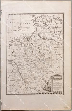
A New & Accurate Map of the North-West Part of Germany, containing Westphalia & Low. Saxony wherein are included y.Domin of y.Electors of Brunswick Lunenburg or Hannover Cologne & c.
Date d'édition : 1747
Vendeur : Asia Bookroom ANZAAB/ILAB, Canberra, ACT, Australie
Membre d'association : ANZAAB ILAB
Evaluation du vendeur :
Copper engraving, some pale browning in places, barely affecting image, minor wear to edges of sheet. Map measures approximately 32 x 22cm. A clear and bright image.
-
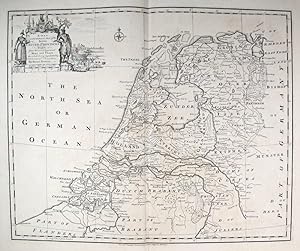
A New and Correct Map of the Seven United Provinces.
Edité par Londonc., 1750
Vendeur : Robert Frew Ltd. ABA ILAB, London, Royaume-Uni
Membre d'association : ABA ILAB PBFA
Evaluation du vendeur :
Carte
34.5 x 42.3 cm. Uncoloured. Copper engraved map of The Netherlands. Title cartouche to upper left corner featuring an illustration of shipbuilding and other nautical references. Two vertical folds. Some light offsetting, otherwise in very good condition.
-
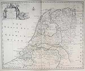
A New and Correct Map of the Seven United Provinces.
Edité par London-47, 1743
Vendeur : Robert Frew Ltd. ABA ILAB, London, Royaume-Uni
Membre d'association : ABA ILAB PBFA
Evaluation du vendeur :
Carte
41 x 48 cm. Uncoloured. Double page map of the Netherlands. Tear without loss at foot of centre fold affecting 2cm of plate. Edges lightly toned. Generally good.
-

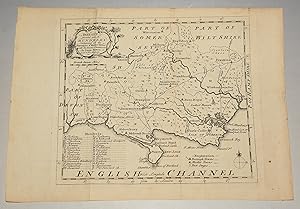
Original Antique Map of ?SURREY Divided into Hundreds? Containing the Borough and Market Towns &c. Roads & Distances.
Edité par London, Printed for General Magazine of Arts and Sciences 1756, 1756
Vendeur : PROCTOR / THE ANTIQUE MAP & BOOKSHOP, DORCHESTER, Royaume-Uni
Membre d'association : PBFA
Evaluation du vendeur :
Unmounted. Size 20cm x 18cm In very good condition. With two neat center folds. A very clean, crisp map. Uncoloured --- Bowen map of SURREY showing Hundreds, towns villages, rivers and post roads. With descriptions of main towns and the County itself. This small series were issued in The Natural History of England which formed part of The General Magazine of Arts and Sciences published from 1755 to 1764.
-
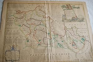
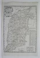
AN ACCURATE MAP OF BERKSHIRE DIVIDED INTO ITS HUNDREDS 1756
Edité par Carington Bonles in St Paul Chuch Yard, London, 1756
Carte
Pas de couverture. Etat : Assez bon. CARTE ANCIENNE AN ACCURATE MAP OF BERKSHIRE DIVIDED INTO ITS HUNDREDS 1756 Drawn from the best authorities asisted by Surveys and most approved maps with vriuous improvements illustrated with historical extracts relative to trade, manufactures, natural produce & present state of the principal town &c. by Eman BOWEN, geographer to his Majesty 1756, London, imprimé par Carington Bonles in St Paul Chuch Yard Carte ancienne illustrée et réhaussée de couleurs ŕ la main, légende en anglais (Gravure authentique du XVIIIe sičcle-original etching) Dimensions de la feuille : 76 x 58,5 cm environ Dimensions de la carte au coup de planche : 68,5 x 53 cm environ Etat : une coupure sans manque en bordure inférieure droite, deux accrocs, beau documents.
-
(Original Engraved Map of.) Dorset, Divided into its Hundreds. Containing all the Market Towns, with Roads & Districts.
Edité par Eman. Bowen, Geog. To His Majesty No date Ca 1758, 1758
Vendeur : PROCTOR / THE ANTIQUE MAP & BOOKSHOP, DORCHESTER, Royaume-Uni
Membre d'association : PBFA
Evaluation du vendeur :
Carte
Original engraved antique hand-coloured map. Size approx 8 x 7 inches In very good condition. Map tanned but printing is clear and crisp. With crease just slightly off-centre.
-

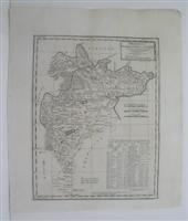
A New & ACCURATE MAP OF SPAIN and PORTUGAL. Drawn from Surveys assisted by ye. most approved Modern Maps and Charts. The whole being Regulated by Astronomical Observations. By Eman. Bowen - Original Antique Map, Printed Circa 1766
Date d'édition : 1766
Vendeur : K Books Ltd ABA ILAB, York, YORKS, Royaume-Uni
Membre d'association : ABA ILAB PBFA
Evaluation du vendeur :
Livre
No Binding. Etat : Very Good. Bowen, Emanuel (illustrateur). Original antique hand-coloured map, colouring not contemporary, but delicately and expertly done. Mounted (matted) and ready to frame. Figurative title cartouche in top right hand corner plus scale, with the legend "A New & ACCURATE MAP OF SPAIN and PORTUGAL. Drawn from Surveys assisted by ye. most approved Modern Maps and Charts. The whole being Regulated by Astronomical Observations. By Eman. Bowen", printed c1766. There are two inset maps of the Minorcan harbour of Port Mahon and a chart of the Straits of Gibraltar accompanied by some notes on the two, together with an explanation of how the details of the coasts of the maps were arrived at - most informative. Includes the Islands of Minorca, Majorca and the northern coast of Africa.
-
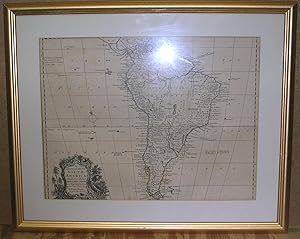
AN ACCURATE MAP OF SOUTH AMERICA; Drawn from the best Modern Maps and Charts, and Regulated by Astron'l. Observations by Eman Bowen, Geog. to His Majesty the King
Edité par Eman Bowen ND (177-90), UK
Vendeur : Dearly Departed Books, Alliance, OH, Etats-Unis
Evaluation du vendeur :
Carte Edition originale
Map. Etat : VG. 1st Impression. This is a 21 1/2" X 18.00" Framed map that was originally Printed in 1 747 but has been updated several times through-out the late 18th Centu ry. This copy,though undated is very similar to the 1763 edition with a few variations. This copy makes note of a Sacrament Colony in the At lantic that was ceded by Treaty to the Spainish by Portugal in 1750. T he cartouche in the left hand side is also different with a forest sce ne decoration. The Map is A VG or better copy, there are two light fo ld marks and mild tanning and offseting to the map. Overall clean an s harp. Comes matted in a glass frame. INTERNATIONAL CUSTOMERS, Please note that shipping costs will be determined on distance and the framed maps' weight of 4 1/2 pounds.
-
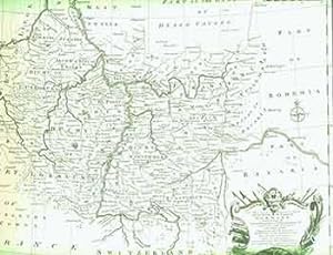
A New and Correct Map of the South West part of Germany, Containing the Archbishopricks and Electorates of Mentz and Triers. (18th Century Map of Germany).
Edité par [London]: 18th Century European Publisher, [1700s]., 1700
Vendeur : Wittenborn Art Books, San Francisco, CA, Etats-Unis
Evaluation du vendeur :
Manuscrit / Papier ancien
Etat : Good. 20 x 16 inches. Very Good. Minor loss from pinholes in top right corner. Fine copperplate engraving. 18th Century, uncolored, folded map of Germany. Scarce.
-
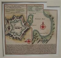
A Plan of the Dutch Fort at the Cape of Good Hope.
Edité par London, 1752
Vendeur : Alexandre Antique Prints, Maps & Books, Toronto, ON, Canada
Membre d'association : ABAC ILAB
Evaluation du vendeur :

Carte
Size : 117x123 (mm), 4.625x4.875 (Inches), Hand Colored Very Good; some age toning; old mounting on heavier paper for long term preservation.
-
A Plan of the Harbour Town and Forts of Porto Bello, when taken by Admiran Vernon on Novr. 22.d 1739 with 6 ships only
Edité par London, 1747
Vendeur : Alexandre Antique Prints, Maps & Books, Toronto, ON, Canada
Membre d'association : ABAC ILAB
Evaluation du vendeur :
Carte
Etat : Very Good; margins extended. Size : 87x149 (mm), 3.375x5.875 (Inches), Hand Colored.
-
North America, Laid Down from the Best Modern Maps with Improvements by Eman Bowen Geo'r to His Majesty 1751
Edité par London, 1751
Vendeur : Frost Pocket Farm - IOBA, Fleetville, PA, Etats-Unis
Membre d'association : IOBA
Evaluation du vendeur :
Paperback. Etat : Good. Original map, on laid paper with chain lines, pasted on to a thin white linen (? ) backing, 7 x 8 Ľ inches, map itself 5 3/8 x 7 3/8 inches, hand colored outlines, title in decorative cartouche. Good. Open ľ inch and 1 ˝ inch tears on right side edge with corresponding ˝ x ˝ x ľ inch chip (just a bit of the colored map border affected) , closed (thanks to backing) 2 ľ inch tear on left, 2 vertical and 1 horizontal folds, with corresponding 2 inch closed tear at lower edge of vertical fold, intersected by a 5 ˝ inch closed tear on the adjoining horizontal fold, two approximately Ľ inch chips, one on margin, other just to the right of Cuba, ˝ inch deep x 3 inch long light tan stain on left blank margin, ľ inch tape(? ) mark on lower edge, touch of foxing, mainly along edges, otherwise clean and unmarked. Depicts western hemisphere from Britain to the Pacific coast, southern portion of Greenland to north coast of South America, with 0 longitude being the Meridian of Ferro. Most of North America west of Hudson Bay through modern Oregon is labeled "Parts Undiscovered", with the "Supposed Str of Annian" being the limits of the then known world, Baja California rather wide, the mostly unknown Rocky Mountains shown as 4 ranges, but the eastern part of America is fairly accurate, a tribute to Bowen! Maps; geography; travel; charts.
-
A Plan of the Town and Harbour of Louisbourg in the Island of Cape Breton
Edité par London, 1747
Vendeur : Alexandre Antique Prints, Maps & Books, Toronto, ON, Canada
Membre d'association : ABAC ILAB
Evaluation du vendeur :
Carte
Etat : Very Good; margins extended. Size : 137x151 (mm), 5.375x6 (Inches), Hand Colored.
-
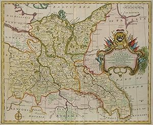
A Correct Map of the Northeast part of Germany. Containing the Electorates of Saxony & Brandenburg, and the Duchies of Silesia, Mecklenburg, Pomerania & c
Date d'édition : 1746
Vendeur : Kunstantiquariat Andreas Senger, Hamburg, Allemagne
Evaluation du vendeur :
Carte
Kein Einband. Etat : Sehr gut. Es handelt sich hierbei um eine originale, kolorierte Kupferstich-Landkarte des Gebiets von Brandenburg, Mecklenburg-Vorpommern und Berlin von Eman Bowen (1714 - 1767) aus dem Jahr 1746. *** Titel: A Correct Map of the Northeast part of Germany. Containing the Electorates of Saxony & Brandenburg, and the Duchies of Silesia, Mecklenburg, Pomerania & c *** Gebiet bzw. Ort: Brandenburg, Mecklenburg-Vorpommern, Berlin *** Kartograph: Eman Bowen (1714 - 1767) *** Jahr: 1746 *** Größe des Plattenbereichs: 35 x 42 cm *** Technik: Kupferstich *** Zustand (Perfekt/ Sehr gut/ Gut/ Ordentlich/ Mäßig/ Schlecht): In sehr gutem Erhaltungszustand *** Bemerkungen: Bei Interesse stelle ich weitere Fotos gerne zur Verfügung. - - - International buyers welcome. If you have any questions, please don't hesitate to ask. --- Auf Wunsch stellen wir Ihnen gerne ein kostenfreies Echtheitszertifikat aus --- If you wish, we will gladly provide a certificate of authenticity free of charge ---.
-
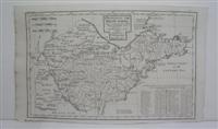
MINORCA / taken from an / Original Drawing / of an Actual / Survey / of the Island: / with some Improve- / ments by Eman:Bowen / Geogr. to his Majesty
Edité par LONDON: Printed for W.Owen, at Homer's Head Temple Bar. 1756., 1756
Vendeur : Paul Orssich HISPANIC STUDIES, LONDON, Royaume-Uni
Evaluation du vendeur :
17.5 x 22.5 cms. Color de época.Bello mapa de Menorca coloreado de época, en pas-partout. Muy buen ejemplar Recuadros: The Harbour of / PORT MAHON + The Streights of Gibraltar / with the Coast of Spain from / Cadiz to Malaga. Publicado en: The General Magazine of Arts and Sciences by Benjamin Martin. The insets note the distances from Mahón to Toulon (197 miles) and Gibraltar (540 miles).Jolly: Maps in British Periodicals. Vol.II. GENMAS 72. Martorell 93 (illustrated).
-
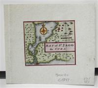
Bay of St. Jago de Cuba
Edité par London, 1747
Vendeur : Alexandre Antique Prints, Maps & Books, Toronto, ON, Canada
Membre d'association : ABAC ILAB
Evaluation du vendeur :
Carte
Size : 57x66 (mm), 2.25x2.625 (Inches), Hand Colored Excellent; mounted on heavier paper.
-
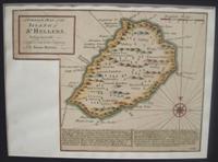
A Correct Map of the Island of St. Hellena, belonging to the English East Infia Company
Edité par London, 1752
Vendeur : Alexandre Antique Prints, Maps & Books, Toronto, ON, Canada
Membre d'association : ABAC ILAB
Evaluation du vendeur :
Size : 160x217 (mm), 6.25x8.5 (Inches), Hand Colored Very Good; some age toning; margins shaved; map mounted on heavier paper for long term preservation.
-
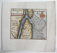
Harbour of St. Augustine
Edité par London, 1752
Vendeur : Alexandre Antique Prints, Maps & Books, Toronto, ON, Canada
Membre d'association : ABAC ILAB
Evaluation du vendeur :
Carte
Size : 59x71 (mm), 2.375x2.75 (Inches), Hand Colored Very Good; mounted on 18th century paper.
-
The Havana
Edité par London, 1747
Vendeur : Alexandre Antique Prints, Maps & Books, Toronto, ON, Canada
Membre d'association : ABAC ILAB
Evaluation du vendeur :
Carte
Etat : Very Good; margins extended. Size : 57x69 (mm), 2.25x2.75 (Inches), Hand Colored.
-
A New & Accurate Map of the Netherlands or Low Countries
Date d'édition : 1747
Vendeur : Kunstantiquariat Andreas Senger, Hamburg, Allemagne
Evaluation du vendeur :
Carte
Kein Einband. Etat : Gut. Es handelt sich hierbei um eine originale, kolorierte Kupferstich-Landkarte der Niederlande von Eman Bowen (1714 - 1767) aus dem Jahr 1747. *** Titel: A New & Accurate Map of the Netherlands or Low Countries *** Gebiet bzw. Ort: Die Niederlande und Belgien *** Kartograph: *** Jahr: 1747 *** Größe des Plattenbereichs: 35 x 43 cm *** Technik: Kupferstich *** Zustand (Perfekt/ Sehr gut/ Gut/ Ordentlich/ Mäßig/ Schlecht): In gutem Erhaltungszustand *** Bemerkungen: Seltene Karte der Niederlande und Belgiens mit einer dekorativen figürlichen Kartusche. - - - International buyers welcome. If you have any questions, please don't hesitate to ask. --- Auf Wunsch stellen wir Ihnen gerne ein kostenfreies Echtheitszertifikat aus --- If you wish, we will gladly provide a certificate of authenticity free of charge ---.
-
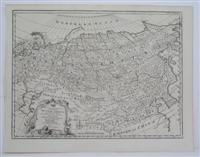
A New Accurate Map of Whole Russian Empire
Edité par London, 1757
Vendeur : Alexandre Antique Prints, Maps & Books, Toronto, ON, Canada
Membre d'association : ABAC ILAB
Evaluation du vendeur :
Carte
Etat : Excellent. Size : 352x468 (mm), 13.875x18.375 (Inches), Black & White.
-
Province IX SHAN-SI
Edité par London, 1738
Vendeur : Alexandre Antique Prints, Maps & Books, Toronto, ON, Canada
Membre d'association : ABAC ILAB
Evaluation du vendeur :
Carte
Size : 360x255 (mm), 14.125x10 (Inches), Black & White Very good, left margin extended.
-

Province II KYANG-NAN
Edité par London, 1738
Vendeur : Alexandre Antique Prints, Maps & Books, Toronto, ON, Canada
Membre d'association : ABAC ILAB
Evaluation du vendeur :
Carte
Etat : Excellent. Size : 375x350 (mm), 14.75x13.75 (Inches), Black & White.
-
Province I PE-CHE-LI, CHE-LI or LI-PA-FU
Edité par London, 1738
Vendeur : Alexandre Antique Prints, Maps & Books, Toronto, ON, Canada
Membre d'association : ABAC ILAB
Evaluation du vendeur :
Carte
Etat : Excellent. Size : 380x295 (mm), 15x11.625 (Inches), Black & White.
-
Province VIII SHAN-TONG
Edité par London, 1738
Vendeur : Alexandre Antique Prints, Maps & Books, Toronto, ON, Canada
Membre d'association : ABAC ILAB
Evaluation du vendeur :
Carte
Etat : Excellent. Size : 240x380 (mm), 9.5x15 (Inches), Black & White.
-
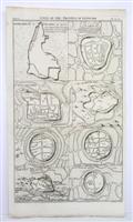
Cities of the Province of Kyang-Nan
Edité par London, 1738
Vendeur : Alexandre Antique Prints, Maps & Books, Toronto, ON, Canada
Membre d'association : ABAC ILAB
Evaluation du vendeur :
Carte
Etat : Very Good. Size : 385x235 (mm), 15.125x9.25 (Inches), Black & White.