
Montant total (1 article articles) :
Destination de la commande :

INDIA, ANTIQUE MAP (24 résultats)
Passer aux résultats principaux de la recherche
Type d'article
- Tous les types d'articles
- Livres (23)
- Magazines & Périodiques
- Bandes dessinées
- Partitions de musique
- Art, Affiches et Gravures (1)
- Photographies
- Cartes
-
Manuscrits &
Papiers anciens
Etat
- Tous
- Neuf
- Ancien ou d'occasion
Reliure
- Toutes
- Couverture rigide
- Couverture souple
Particularités
- Edition originale (1)
- Signé
- Jaquette
- Avec images (3)
- Sans impression ŕ la demande
Pays
Evaluation du vendeur
-

Northern India - an Antique Map
Edité par London, 1890
Vendeur : K Books Ltd ABA ILAB, York, YORKS, Royaume-Uni
Membre d'association : ABA ILAB PBFA
Evaluation du vendeur :

Livre
No Binding. Etat : Very Good. An attractive coloured map - excellent condition . mounted - matted - and ready to frame. Mount size approx 9 x 7 inches , 27 x 21 cms. Circa 1890 , An excellent map of .Northern India.
-
India - an Antique Map
Edité par London, 1890
Vendeur : K Books Ltd ABA ILAB, York, YORKS, Royaume-Uni
Membre d'association : ABA ILAB PBFA
Evaluation du vendeur :
Livre
No Binding. Etat : Very Good. An attractive coloured map - excellent condition . mounted - matted - and ready to frame. Mount size approx 9 x 7 inches , 27 x 21 cms. Circa 1890 , An excellent map of . India.
-
Map - Hindoostan - 19th Century
Date d'édition : 1880
Vendeur : K Books Ltd ABA ILAB, York, YORKS, Royaume-Uni
Membre d'association : ABA ILAB PBFA
Evaluation du vendeur :
Livre
No Binding. Etat : Very Good. An antique map, very good condition. Mounted - matted - and ready to frame. Mount size approx 12 x 10 inches, 36 x 30 cms. Original contemporary colouring. Circa 1880. Very detailed - Shows --- India - Hindoostan - attractively coloured reasonably priced - quite detailed.
-
Map of India - an Antique Coloured Map
Date d'édition : 1865
Vendeur : K Books Ltd ABA ILAB, York, YORKS, Royaume-Uni
Membre d'association : ABA ILAB PBFA
Evaluation du vendeur :
Livre
No Binding. Etat : Very Good. An original antique coloured Map . colouring contemporary but expertly and delicately executed. Mounted - matted - and ready to frame. Very good condition - a splendid map - shows India circa 1865.
-
India - An Antique Coloured Map Printed Circa 1870
Edité par H G Collins, London, 1870
Vendeur : K Books Ltd ABA ILAB, York, YORKS, Royaume-Uni
Membre d'association : ABA ILAB PBFA
Evaluation du vendeur :
Livre
No Binding. Etat : Very Good. J Archer (illustrateur). An attractive original antique coloured map . Mounted - matted - and ready to frame . Very good condition . Somewhat uncommon . Shows the Northern Part of India in some detail. Unobtrusive central fold.
-
Bombay Diocese . An Antique Coloured Map
Date d'édition : 1843
Vendeur : K Books Ltd ABA ILAB, York, YORKS, Royaume-Uni
Membre d'association : ABA ILAB PBFA
Evaluation du vendeur :
Livre
No Binding. Etat : Very Good. A fine original antique coloured map printed in 1843 . Mounted - matted - and ready to frame . Very good condition and somewhat uncommon . Detailed map - for the Church Missionary Society - showing the Bombay Diocese - which covered hundreds of miles - detailed.
-
Antique Map - Ancient India
Edité par Stanford, London, 1857
Vendeur : K Books Ltd ABA ILAB, York, YORKS, Royaume-Uni
Membre d'association : ABA ILAB PBFA
Evaluation du vendeur :
Livre Edition originale
No Binding. Etat : Very Good. First Edition. An antique coloured map- colouring contemporary but expertly and delicately executed - very good condition . Mounted - matted - and ready to frame . . Shows Ancient Inia - Northern Part - very detailed - - very attractive and in excellent condition.
-
India, Hindoostan, Original Antique Map
Date d'édition : 1899
Vendeur : K Books Ltd ABA ILAB, York, YORKS, Royaume-Uni
Membre d'association : ABA ILAB PBFA
Evaluation du vendeur :
Livre
No Binding. Etat : Very Good. A superb antique map of Hindoostan. - probably printed about 1899. 11x9.5 ins 28x24 cms, mounted and ready to frame. A splendid oportunity to acquire a scarce and unusual original map.
-
India - Showing Oriss, Hyrabad, Circars Etc - an Antique Map
Vendeur : K Books Ltd ABA ILAB, York, YORKS, Royaume-Uni
Membre d'association : ABA ILAB PBFA
Evaluation du vendeur :
Livre
No Binding. Etat : Very Good. Engraved By Walker (illustrateur). A fine antique map in very good condition - printed in circa 1844. Mounted (matted) and ready to frame. Engraved Size 14 x 10 Ins 35 x 25 cms. Mount size approx 17 x 13 ins, 43 x33 cms. Coloured in outline, hand colouring contemporary. A fine engraved map of India - Showing Oriss, Hyrabad, Circars Etc.
-
India - Showing Harraoutee, Bhopai, Goondwana, Khadnelish Etc - an Antique Map
Vendeur : K Books Ltd ABA ILAB, York, YORKS, Royaume-Uni
Membre d'association : ABA ILAB PBFA
Evaluation du vendeur :
Livre
No Binding. Etat : Very Good. Engraved By Walker (illustrateur). A fine antique map in very good condition - printed in circa 1844. Mounted (matted) and ready to frame. Engraved Size 14 x 10 Ins 35 x 25 cms. Mount size approx 17 x 13 ins, 43 x 33 cms. Coloured in outline, hand colouring contemporary. A fine engraved map of India - Showing Harraoutee, Bhopai, Goondwana, Khadnelish Etc.
-
India - Showing the British Territory, Rajah of Berar, Rajaj of Rewah, & Bundlecund Chiefs - an Antique Map
Vendeur : K Books Ltd ABA ILAB, York, YORKS, Royaume-Uni
Membre d'association : ABA ILAB PBFA
Evaluation du vendeur :
Livre
No Binding. Etat : Very Good. Engraved By Walker (illustrateur). A fine antique map in very good condition - printed in circa 1844. Mounted (matted) and ready to frame. Engraved Size 14 x 10 Ins 35 x 25 cms. Mount size approx 17 x 13 ins, 43 x 33 cms. Coloured in outline, hand colouring contemporary. A fine engraved map of India - Showing the British Territory, Rajah of Berar, Rajaj of Rewah, & Bundlecund Chiefs.
-
India - Showing the British Territory, Sirohi, Marwar, Rajah of Dholpoor Barree, King of Ude Etc - an Antique Map
Vendeur : K Books Ltd ABA ILAB, York, YORKS, Royaume-Uni
Membre d'association : ABA ILAB PBFA
Evaluation du vendeur :
Livre
No Binding. Etat : Very Good. Engraved By Walker (illustrateur). A fine antique map in very good condition - printed in circa 1844. Mounted (matted) and ready to frame. Engraved Size 14 x 10 Ins 35 x 25 cms. Mount size approx 17 x 13 ins, 43 x 33 cms. Coloured in outline, hand colouring contemporary. A fine engraved map of India - Showing the British Territory, Sirohi, Marwar, Rajah of Dholpoor Barree, King of Ude Etc.
-
ALEXANDER THE GREAT'S ITINERARY THROUGH MACEDONIA, LIBYA AND INDIA - Original Antique Map, Contemporary Colouring
Edité par R Wilkinson, London, 1807
Vendeur : K Books Ltd ABA ILAB, York, YORKS, Royaume-Uni
Membre d'association : ABA ILAB PBFA
Evaluation du vendeur :
Livre
No Binding. Etat : Very Good. B SMITH (illustrateur). A splendid original antique map. Contemporary colouring and in excellent condition. Mounted and ready to frame. Extremely decorative and printed in 1807. Detailed and attractive map showing the route of Alexander the Great - "Alexandri Magni Itinera in expeditione inter Macedoniam, Libyam et Indiam, cum Navicationem Nearchi, ab Indo et Tigri Fluminibus".
-
India - a Splendid Antique Hand Coloured Map
Date d'édition : 1842
Vendeur : K Books Ltd ABA ILAB, York, YORKS, Royaume-Uni
Membre d'association : ABA ILAB PBFA
Evaluation du vendeur :
Livre
No Binding. Etat : Very Good. A splendid original antique hand coloured map . Mounted (matted) and ready to frame . Very good condition . Map of India by Juland Danvers . Quite detailed . Shows British Possessions in 1784.
-
India - Showing the British Territory, Rajah of Berar, Rajaj of Rewah, & Bundlecund Chiefs - an Antique Map
Vendeur : K Books Ltd ABA ILAB, York, YORKS, Royaume-Uni
Membre d'association : ABA ILAB PBFA
Evaluation du vendeur :
Livre
No Binding. Etat : Very Good. Engraved By Walker (illustrateur). A fine antique map in very good condition - printed in circa 1844. Mounted (matted) and ready to frame. Engraved Size 14 x 10 Ins 35 x 25 cms. Mount size approx 17 x 13 ins, 43 x 33 cms. Coloured in outline, hand colouring contemporary. A fine engraved map of India - Showing the British Territory, Rajah of Berar, Rajaj of Rewah, & Bundlecund Chiefs.
-
India - Showing Cude and Aliahabad - an Antique Map
Vendeur : K Books Ltd ABA ILAB, York, YORKS, Royaume-Uni
Membre d'association : ABA ILAB PBFA
Evaluation du vendeur :
Livre
No Binding. Etat : Very Good. Engraved By Walker (illustrateur). A fine antique map in very good condition - printed in circa 1844. Mounted (matted) and ready to frame. Engraved Size 14 x 10 Ins 35 x 25 cms. Mount size approx 17 x 13 ins, 43 x 33 cms. Coloured in outline, hand colouring contemporary. A fine engraved map of India - Showing Cude and Aliahabad.
-
India - Showing British Territory - China and Nepal - an Antique Map
Vendeur : K Books Ltd ABA ILAB, York, YORKS, Royaume-Uni
Membre d'association : ABA ILAB PBFA
Evaluation du vendeur :
Livre
No Binding. Etat : Very Good. Engraved By Walker (illustrateur). A fine antique map in very good condition - printed in circa 1844. Mounted (matted) and ready to frame. Engraved Size 14 x 10 Ins 35 x 25 cms. Mount size approx 17 x 13 ins, 43 x 33 cms. Coloured in outline, hand colouring contemporary. A fine engraved map of India - Showing British Territory - China and Nepal.
-
Map of Arabia, Persia, India Etc - Fine Detailed Map - an Original Engraving
Date d'édition : 1800
Vendeur : K Books Ltd ABA ILAB, York, YORKS, Royaume-Uni
Membre d'association : ABA ILAB PBFA
Evaluation du vendeur :
Livre
No Binding. Etat : Very Good. A fine engraving - printed circa 1800. Mounted and ready to frame. Hand colouring not contemporary, but delicately and expertly executed. A fine opportunity to purchase an attractive and decorative engraving - Map of Arabia, Persia, India Etc.
-
Map of Southern India - Fine Detailed Map - an Original Engraving
Date d'édition : 1860
Vendeur : K Books Ltd ABA ILAB, York, YORKS, Royaume-Uni
Membre d'association : ABA ILAB PBFA
Evaluation du vendeur :
Livre
No Binding. Etat : Very Good. A fine engraving - printed circa 1860. Mounted and ready to frame. Hand colouring not contemporary, but delicately and expertly executed. A fine opportunity to purchase an attractive and decorative engraving - Map of Southern India.
-
Indian Ocean, India and Australia Etc - an Antique Map
Vendeur : K Books Ltd ABA ILAB, York, YORKS, Royaume-Uni
Membre d'association : ABA ILAB PBFA
Evaluation du vendeur :
Livre
No Binding. Etat : Very Good. Engraved By Walker (illustrateur). A fine antique map - printed in 1844. Mounted (matted) and ready to frame. Engraved Size 12 x 10 Ins, 30 x 26 Cms. Mounted size approx 15 x 13 ins, 38 x 33cms. Coloured in outline, hand colouring contemporary. A fine opportunity to purchase an attractive and decorative engraved antique map of the Indian Ocean, India and Australia Etc.
-
India - Madras Presidency - an Antique Map
Vendeur : K Books Ltd ABA ILAB, York, YORKS, Royaume-Uni
Membre d'association : ABA ILAB PBFA
Evaluation du vendeur :
Livre
No Binding. Etat : Very Good. Engraved By Walker (illustrateur). A fine antique map in very good condition - printed in circa 1844. Mounted (matted) and ready to frame. Engraved Size 12 x 10 Ins, 30 x 26 Cms. Mounted size approx 15 x 13 ins, 38 x 33cms. Coloured in outline, hand colouring contemporary. A fine engraved map of India - Madras Presidency.
-
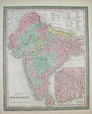
Hindoostan.
Edité par Thomas, Cowperthwait & Co., Pennsylvania., 1850
Vendeur : Asia Bookroom ANZAAB/ILAB, Canberra, ACT, Australie
Membre d'association : ANZAAB ILAB
Evaluation du vendeur :
Handcoloured engraved map, 38.6 x 31.3 cms; 43.5 x 35 (sheet), inset of the Ganges delta, key to colonial possessions, edge toning and an inconsequential marginal chip, in very good condition. A handsome detailed map of India and Ceylon showing parts of neighbouring Pakistan, Afghanistan, Tibet and Bhutan. Colonial British territories and the independent states are attractively handcoloured.
-

Rajpootana and Adjoining States Sheet No. 4.
Edité par Surveyor Generals Office. 1870. Reissue of 1859 edition., Calcutta., 1870
Vendeur : Asia Bookroom ANZAAB/ILAB, Canberra, ACT, Australie
Membre d'association : ANZAAB ILAB
Evaluation du vendeur :
Lithographed map 57.2 x 93 cms; 61.1 x 96 cms (sheet), original folds, old paper repairs to the verso and a sealed marginal tear, central folds archivally strengthened, some toning to the folds and creasing, but the map in remarkably good, clean condition. Impressive large Calcutta printing from the Survey of India showing Rajasthan, Uttar Pradesh and surrounding states with extremely detailed delineation of settlements, roads, railways, rivers and major points of interest (the Taj Mahal is highlighted).
-
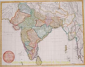
Charte von Hindostan und der Halbinsel nach Rennels, Campbells, Pringles, Diroms Zeichnungen entworfenLarge folding decorative map of the Indian subcontinent
Vendeur : Inter-Antiquariaat Mefferdt & De Jonge, Amsterdam, Pays-Bas
Membre d'association : ILAB NVVA
Evaluation du vendeur :
Art / Affiche / Gravure
Charte von Hindostan und der Halbinsel nach Rennels, Campbells, Pringles, Diroms Zeichnungen entworfenLarge folding decorative map of the Indian subcontinent. Made by Conrad Mannert, published in Nürnberg by A. G. Schneider u. Weigel, 1804. Original hand colouring with later additions. Size 53,6 x 69,7 cm. Price: Euro350,- (excl. VAT, excl frame).
