
Montant total (1 article articles) :
Destination de la commande :

RAPKIN, J TALLIS, JOHN (304 résultats)
Passer aux résultats principaux de la recherche
Type d'article
- Tous les types d'articles
- Livres (111)
- Magazines & Périodiques
- Bandes dessinées
- Partitions de musique
- Art, Affiches et Gravures
- Photographies
- Cartes (193)
-
Manuscrits &
Papiers anciens
Etat
- Tous
- Neuf
- Ancien ou d'occasion
Reliure
- Toutes
- Couverture rigide
- Couverture souple (1)
Particularités
- Edition originale (9)
- Signé
- Jaquette
- Avec images (290)
- Sans impression ŕ la demande
Pays
Evaluation du vendeur
-
Independent Tartary [Antique Map]
Edité par The London Printing and Publishing Company, London, 1855
Vendeur : Books & Bidders Antiquarian Booksellers, Cleveland, OH, Etats-Unis
Evaluation du vendeur :

Carte
Etat : Very Good. [Map]. Original steel engraved map with decorative boarder and vignettes. Map size with central vertical fold is approx. 11 x 14 inches. Antique map of "Independent Tartary" N.D. (no date, circa 1855). Vignettes of Tartars on a Journey, The Bride Chase, and The Tent. Map scale in British miles. Map drawn and engraved by J. Rapkin, with illustrations by W. Bragg and engraved by J. Rogers. Contemporary pen outlining in color. By 1865 Tallis was among the last of the publishers of beautifully decorated hand engraved maps. Shows some expected page toning and light wear at corners. Map.
-
New Zealand [Antique Map]
Edité par John Tallis, London, 1851
Vendeur : Books & Bidders Antiquarian Booksellers, Cleveland, OH, Etats-Unis
Evaluation du vendeur :
Carte
Etat : Good. [New Zealand Map]. Original steel engraved map with decorative boarder and vignettes. Map size with central vertical fold is 14 x 11 inches. Antique map of "New Zealand" by John Tallis & Company, circa 1851. Vignettes of Auckland, Mount Egmont from New Plymouth, Wellington, and Indigenous person. Map drawn and engraved by John Rapkin, with illustrations by H. Warren and engraved by J.B. Allen. Contemporary pen outlining in color and pale blue coastline wash. By 1865 Tallis was among the last of the publishers of beautifully decorated hand engraved maps. Trimmed at top and bottom, with some light expected page toning. Map.
-
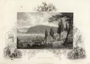
View of Newburgh
Edité par London, 1850
Vendeur : Antipodean Books, Maps & Prints, ABAA, Garrison, NY, Etats-Unis
Membre d'association : ABAA ANZAAB ESA ILAB
Evaluation du vendeur :

Charming pastoral view of early homes, cows, the Hudson & Storm King Mountain in the distance. Steel engraving ca. 1850. B&w image approx 9x7", on paper approx. 10x8". Tallis was known for the handsome vignette views which illustrate the margins of the print, in this case Columbus with the King & Queen of Spain, the Huguenots Landing in America & a preacher exorting native americans.
-
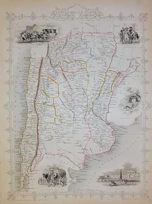
CHILI (CHILE) AND LA PLATA
Edité par London Printing and Publishing Company, London, UK, 1851
Edition originale
No Binding. Etat : Near Fine. 1st Edition. 1st edition. DH202314. Printed in 1851 and published by the London Printing and Publishing Company. Size: 35cm x 26cm. Original steel engraving with original hand-colouring. Very slightly spotted. In near fine condition overall.
-

FALKLAND ISLANDS AND PATAGONIA BY J RAPKIN FOR JOHN TALLIS, 1851.
Edité par London Printing and Publishing Company, London, UK, 1851
Edition originale
No Binding. Etat : Near Fine. 1st Edition. 1st edition. DH202313. Printed in 1851 and published by the London Printing and Publishing Company. Size: 35cm x 26cm. Original steel engraving with original hand-colouring. Slightly trimmed to the top margin. In near fine condition overall.
-
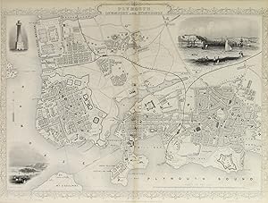
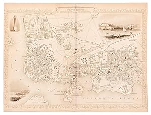
Plymouth, Devonport and Stonehouse.
Edité par London & New YorkJohn Tallis & Company c., 1856
Vendeur : Robert Frew Ltd. ABA ILAB, London, Royaume-Uni
Membre d'association : ABA ILAB PBFA
Evaluation du vendeur :
Carte
25 x 35 cm. Double page steel engraved plan. Vignette llustrations of Devonport and Plymouth Sound. Decorative scrolling and title cartouche around the edges of the image. Light horizontal shadow line at centre from original fold. For the Great Exhibition in 1851 John Tallis (1817-1876) worked with engraver John Rapkin (1815-1876) to publish the 'Illustrated World Atlas', whose maps were later re-issued by the London Printing and Publishing Company under the Tallis imprint. Their maps are prized for their wonderful steel-engraved vignettes showing the peoples, customs, architecture, landmarks, flora, and fauna of each country.
-

Plymouth, Devonport and Stonehouse.
Edité par London & New YorkJohn Tallis & Company c., 1856
Vendeur : Robert Frew Ltd. ABA ILAB, London, Royaume-Uni
Membre d'association : ABA ILAB PBFA
Evaluation du vendeur :
Carte
25 x 35 cm. Double page steel engraved plan. Vignette llustrations of Devonport and Plymouth Sound. Decorative scrolling and title cartouche around the edges of the image. Very good. For the Great Exhibition in 1851 John Tallis (1817-1876) worked with engraver John Rapkin (1815-1876) to publish the 'Illustrated World Atlas', whose maps were later re-issued by the London Printing and Publishing Company under the Tallis imprint. Their maps are prized for their wonderful steel-engraved vignettes showing the peoples, customs, architecture, landmarks, flora, and fauna of each country.
-
Plymouth, Devonport and Stonehouse.
Edité par London & New YorkJohn Tallis & Company -1856., 1851
Vendeur : Robert Frew Ltd. ABA ILAB, London, Royaume-Uni
Membre d'association : ABA ILAB PBFA
Evaluation du vendeur :
Carte
Original steel engraved plan. Vignette illustrations of Devonport and Plymouth Sound. Decorative scrolling and title cartouche around the edges of the image. (Map 22 x 29.5 cm, overall sheet 27.5 x 36 cm). Original outline colour. Centrefold crease as issued. In very good condition. For the Great Exhibition in 1851 John Tallis (1817-1876) worked with engraver John Rapkin (1815-1876) to publish the 'Illustrated World Atlas', whose maps were later re-issued by the London Printing and Publishing Company. Their maps are prized for their wonderful steel-engraved vignettes showing the peoples, customs, architecture, landmarks, flora, and fauna of each country.
-

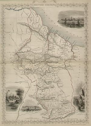
British Guayana, antique map with vignette views
Edité par John Tallis & Co., London, 1854
Vendeur : Antipodean Books, Maps & Prints, ABAA, Garrison, NY, Etats-Unis
Membre d'association : ABAA ANZAAB ESA ILAB
Evaluation du vendeur :
Maps. Steel engraved map from the famous Victorian publisher John Tallis, well-known for the attractive vignette views surrounding the maps, which illustrate the peoples & customs of the region. Vignettes include: Georgetown, Christmas Cataract, New Amsterdam, and Ataraipu or the Devil's Rock. 10 x 12 1/2" plus margins. Attractive decorative border around edge, period outline color, very good condition.
-
Turkey in Europe, antique map with vignette views
Edité par John Tallis & Co., London, 1854
Vendeur : Antipodean Books, Maps & Prints, ABAA, Garrison, NY, Etats-Unis
Membre d'association : ABAA ANZAAB ESA ILAB
Evaluation du vendeur :
Maps. Steel engraved map from the famous Victorian publisher John Tallis, well-known for the attractive vignette views surrounding the maps, which illustrate the peoples & customs of the region. 12 1/2 x 10" plus margins. Attractive decorative border around edge, period outline color, very good condition.
-
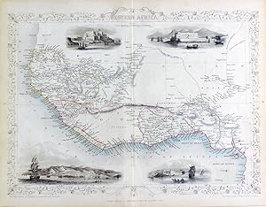
Western Africa, antique map with vignette views
Edité par John Tallis & Co., London, 1854
Vendeur : Antipodean Books, Maps & Prints, ABAA, Garrison, NY, Etats-Unis
Membre d'association : ABAA ANZAAB ESA ILAB
Evaluation du vendeur :
Maps. Steel engraved map from the famous Victorian publisher John Tallis, well-known for the attractive vignette views surrounding the maps, which illustrate the peoples & customs of the region. 12 1/2 x 10" plus margins. Attractive decorative border around edge, period outline color, very good condition.
-
Northern Africa, antique map with vignette views
Edité par John Tallis & Co., London, 1854
Vendeur : Antipodean Books, Maps & Prints, ABAA, Garrison, NY, Etats-Unis
Membre d'association : ABAA ANZAAB ESA ILAB
Evaluation du vendeur :
Maps. Steel engraved map from the famous Victorian publisher John Tallis, well-known for the attractive vignette views surrounding the maps, which illustrate the peoples & customs of the region. 12 1/2 x 10" plus margins. Attractive decorative border around edge, period outline color, very good condition.
-
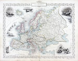
Europe, antique map with vignette views
Edité par John Tallis & Co., London, 1854
Vendeur : Antipodean Books, Maps & Prints, ABAA, Garrison, NY, Etats-Unis
Membre d'association : ABAA ANZAAB ESA ILAB
Evaluation du vendeur :
Maps. Steel engraved map from the famous Victorian publisher John Tallis, well-known for the attractive vignette views surrounding the maps, which illustrate the peoples & customs of the region. 12 1/2 x 10" plus margins. Attractive decorative border around edge, period outline color, very good condition.
-
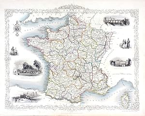
France, antique map with vignette views
Edité par John Tallis & Co., London, 1854
Vendeur : Antipodean Books, Maps & Prints, ABAA, Garrison, NY, Etats-Unis
Membre d'association : ABAA ANZAAB ESA ILAB
Evaluation du vendeur :
Maps. Steel engraved map from the famous Victorian publisher John Tallis, well-known for the attractive vignette views surrounding the maps, which illustrate the peoples & customs of the region. 12 1/2 x 10" plus margins. Attractive decorative border around edge, period outline color, very good condition.
-
British Guayana.
Edité par Londonc., 1855
Vendeur : Robert Frew Ltd. ABA ILAB, London, Royaume-Uni
Membre d'association : ABA ILAB PBFA
Evaluation du vendeur :
Carte
34 x 24.5 cm. Original outline colour. Double page steel engraved map, accompanied by vignette scenes of Georgetown, Ataraipu "or the Devil's Rock", New Amsterdam and Christmas Cataract on thr River Berbice. Decorative scrolling and title cartouche around the edges of the maps. Very good condition. For the Great Exhibition in 1851 John Tallis (1817-1876) worked with engraver John Rapkin (1815-1876) to publish the 'Illustrated World Atlas', whose maps were later re-issued by the London Printing and Publishing Company under the Tallis imprint. Their maps are prized for their wonderful steel-engraved vignettes showing the peoples, customs, architecture, landmarks, flora, and fauna of each country.
-
Nova Scotia and Newfoundland
Edité par John Tallis & Company, London and New York
Vendeur : Antiquarius Booksellers, Falkland, BC, Canada
Evaluation du vendeur :

Carte
Map, Paper. Etat : Good VG or Better. J. Rapkin (illustrateur). Hand-coloured, engraved map of Nova Scotia and Newfoundland, showing parts of Labrador, Canada East, New Brunswick and Prince Edward Island. Surrounded by and engaved fram and five decorative vignettes - medlas of Nova Scotia and Cape Breton plus Newfoundland, Halifax Nova Scotia, Cod Fishery off Newfoundland and two Dogs with barrels and an anchor at the bottom centre. Illustrations by Fussell, engraved by Rogers. Email for scan/info. Reduced price!!!.
-
Part of South Australia [Antique Map]
Edité par John Tallis, London, 1851
Vendeur : Books & Bidders Antiquarian Booksellers, Cleveland, OH, Etats-Unis
Evaluation du vendeur :
Carte
Etat : Very Good. [Australia Map]. Original steel engraved map with decorative boarder and vignettes. Map size with central vertical fold is approx. 11 x 14 inches. Original antique map of "part of South Australia" by John Tallis & Company, circa 1851. Vignettes of Adelaide, Natives of Catmaran, Dingo or Australian Dog, Seal of South Australia, and Nymphicua bird. Map drawn and engraved by John Rapkin, with illustrations by H. Warren and engraved by J. Rogers. Contemporary pen outlining in color and pale blue coastline wash. By 1865 Tallis was among the last of the publishers of beautifully decorated hand engraved maps. Shows some expected page toning and light wear at corners. Map.
-
Western Australia, Swan River [Antique Map]
Edité par John Tallis, London, 1851
Vendeur : Books & Bidders Antiquarian Booksellers, Cleveland, OH, Etats-Unis
Evaluation du vendeur :
Carte
Etat : Very Good. [Australia Map]. Original steel engraved map with decorative boarder and vignettes. Map size with central vertical fold is approx. 11 x 14 inches. Original antique map of "Western Australia, Swan River" by John Tallis & Company, circa 1851. Vignettes of Sheep Shearing, Between Perth and Fremantle, Aborigines, Perth from Mount Eliza, Shepards and sheep, and Ships in harbor. Map drawn and engraved by John Rapkin, with illustrations by A.H. Wray and engraved by W. Lacey. Contemporary pen outlining in color and pale blue coastline wash. By 1865 Tallis was among the last of the publishers of beautifully decorated hand engraved maps. Shows some expected page toning and light wear at corners. Map.
-
Van Diemen's Island or Tasmania [Antique Map]
Edité par John Tallis, London, 1851
Vendeur : Books & Bidders Antiquarian Booksellers, Cleveland, OH, Etats-Unis
Evaluation du vendeur :
Carte
Etat : Very Good. [Tasmania Map]. Original steel engraved map with decorative boarder and vignettes. Map size with central vertical fold is approx. 11 x 14 inches. Original antique map of "Van Diemen's Island or Tasmania" by John Tallis & Company, circa 1851. Vignettes of Hobart Town, Residence of the V.D.I. Campany's Agent Circular Head, Thylacinus Cynocephalus. Map drawn and engraved by J. Rapkin, with illustrations by H. Warren and engraved by J. Rogers. Contemporary pen outlining in color. By 1865 Tallis was among the last of the publishers of beautifully decorated hand engraved maps. Shows some expected light page toning and wear. Map.
-
Polynesia, Islands in the Pacific Ocean [Antique Map]
Edité par John Tallis, London, 1851
Vendeur : Books & Bidders Antiquarian Booksellers, Cleveland, OH, Etats-Unis
Evaluation du vendeur :
Carte
Etat : Very Good. [Polynesia Map]. Original steel engraved map with decorative boarder and vignettes. Map size with central vertical fold is approx. 11 x 14.25 inches. Original antique map of "Polynesia, Islands in the Pacific Ocean" by John Tallis & Company, circa 1851. Vignettes of Kalakakooa Sandwich Islands, Otaheite, Harbor of Dory New Guinea, Resolution Bay Marquesas. Map drawn and engraved by J. Rapkin, with illustrations by H. Winkles and engraved by T. Wrightson. Contemporary pen outlining in color. By 1865 Tallis was among the last of the publishers of beautifully decorated hand engraved maps. Shows some expected page toning and light wear. Map.
-

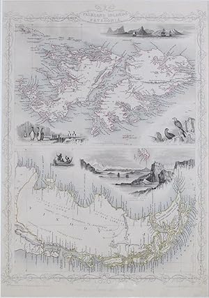
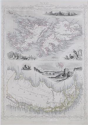
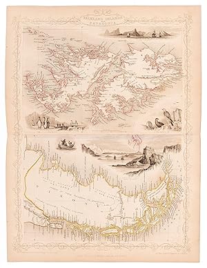
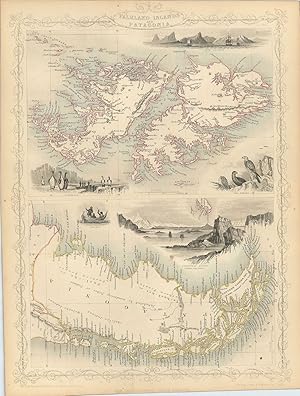
Falkland Islands and Patagonia.
Edité par London & New YorkJohn Tallis & Company., 1856
Vendeur : Robert Frew Ltd. ABA ILAB, London, Royaume-Uni
Membre d'association : ABA ILAB PBFA
Evaluation du vendeur :
Carte
35.5 x 28cm. Original outline colour. Two steel engraved maps on one double page sheet. The upper showing the Falkland Islands. with vignette scenes of the Jason Islands and of Sea Eagles. The lower image showing Patagonia, with vignette scenes of Christmas Sound, Tierra Del Fuego and of "Fuegans." Decorative scrolling and title cartouche around the edges of the maps. Light horizontal shadow line at centre from original fold.
-
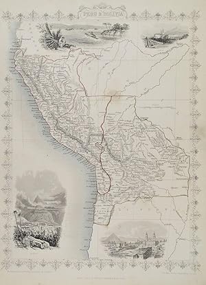
Peru & Bolivia.
Edité par London:, 1851
Vendeur : Robert Frew Ltd. ABA ILAB, London, Royaume-Uni
Membre d'association : ABA ILAB PBFA
Evaluation du vendeur :
Carte
35 x 26.5cm. Original outline colour. Double page steel engraved map. Four vignette illustrations. Decorative scrolling and title cartouche around the edges of the image. Good condition. For the Great Exhibition in 1851 John Tallis (1817-1876) worked with engraver John Rapkin (1815-1876) to publish the 'Illustrated World Atlas', whose maps were later re-issued by the London Printing and Publishing Company under the Tallis imprint. Their maps are prized for their wonderful steel-engraved vignettes showing the peoples, customs, architecture, landmarks, flora, and fauna of each country.
-
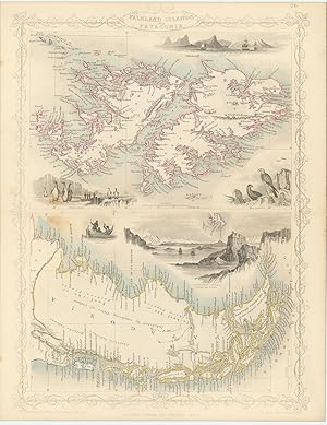
Falkland Islands and Patagonia.
Edité par London:, 1851
Vendeur : Robert Frew Ltd. ABA ILAB, London, Royaume-Uni
Membre d'association : ABA ILAB PBFA
Evaluation du vendeur :
Carte
35 x 27cm. Original outline colour. Double page steel engraved map. Five vignette illustrations including depictions of penguins and sea eagles. Decorative scrolling and title cartouche around the edges of the image. Good condition. For the Great Exhibition in 1851 John Tallis (1817-1876) worked with engraver John Rapkin (1815-1876) to publish the 'Illustrated World Atlas', whose maps were later re-issued by the London Printing and Publishing Company under the Tallis imprint. Their maps are prized for their wonderful steel-engraved vignettes showing the peoples, customs, architecture, landmarks, flora, and fauna of each country.
-
Falkland Islands and Patagonia.
Edité par London & New YorkJohn Tallis & Company., 1851
Vendeur : Robert Frew Ltd. ABA ILAB, London, Royaume-Uni
Membre d'association : ABA ILAB PBFA
Evaluation du vendeur :
Carte
36 x 25cm. Original outline colour. Two steel engraved maps on one double page sheet. The upper showing the Falkland Islands. with vignette scenes of the Jason Islands and of Sea Eagles. The lower image showing Patagonia, with vignette scenes of Christmas Sound, Tierra Del Fuego and of "Fuegans." Decorative scrolling and title cartouche around the edges of the maps. For the Great Exhibition in 1851 John Tallis (1817-1876) worked with engraver John Rapkin (1815-1876) to publish the 'Illustrated World Atlas', whose maps were later re-issued by the London Printing and Publishing Company under the Tallis imprint. Their maps are prized for their wonderful steel-engraved vignettes showing the peoples, customs, architecture, landmarks, flora, and fauna of each country.
-
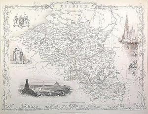
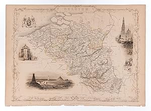
Belgium.
Edité par London Edinburgh & DublinJ & F Tallis., 1851
Vendeur : Robert Frew Ltd. ABA ILAB, London, Royaume-Uni
Membre d'association : ABA ILAB PBFA
Evaluation du vendeur :
Carte
24.5 x 33 cm. Original outline colour. Double page steel engraved map of Belgium. Three vignette illustrations, including one of Antwerp. Decorative scrolling and title cartouche around the edges of the image. Old library stamps to verso. Evenly spotted. For the Great Exhibition in 1851 John Tallis (1817-1876) worked with engraver John Rapkin (1815-1876) to publish the 'Illustrated World Atlas', whose maps were later re-issued by the London Printing and Publishing Company under the Tallis imprint. Their maps are prized for their wonderful steel-engraved vignettes showing the peoples, customs, architecture, landmarks, flora, and fauna of each country.
-
Belgium.
Edité par London Edinburgh & DublinJ & F Tallis., 1851
Vendeur : Robert Frew Ltd. ABA ILAB, London, Royaume-Uni
Membre d'association : ABA ILAB PBFA
Evaluation du vendeur :
Carte
25.5 x 33 cm. Original outline colour. Steel engraved map of Belgium. Three vignette illustrations, including one of Antwerp. Decorative scrolling and title cartouche around the edges of the image. Tightly cropped to upper margin, not affecting the map itself.
-
Falkland Islands and Patagonia.
Edité par London & New YorkJohn Tallis & Company -1856., 1851
Vendeur : Robert Frew Ltd. ABA ILAB, London, Royaume-Uni
Membre d'association : ABA ILAB PBFA
Evaluation du vendeur :
Carte
Two original steel engraved maps on one sheet. The upper showing the Falkland Islands, with vignette scenes of the Jason Islands and of Sea Eagles. The lower image showing Patagonia, with vignette scenes of Christmas Sound, Tierra Del Fuego and of "Fuegans." Decorative scrolling and title cartouche around the edges of the maps. (Map 22 x 29.5 cm, overall sheet 27.5 x 36 cm). Original outline colour. Centrefold crease as issued. In very good condition. For the Great Exhibition in 1851 John Tallis (1817-1876) worked with engraver John Rapkin (1815-1876) to publish the 'Illustrated World Atlas', whose maps were later re-issued by the London Printing and Publishing Company. Their maps are prized for their wonderful steel-engraved vignettes showing the peoples, customs, architecture, landmarks, flora, and fauna of each country.
-
Falkland Islands and Patagonia.
Edité par The London Printing and Publishing Company -1856., 1851
Vendeur : Robert Frew Ltd. ABA ILAB, London, Royaume-Uni
Membre d'association : ABA ILAB PBFA
Evaluation du vendeur :
Carte
Two original steel engraved maps on one sheet. The upper showing the Falkland Islands, with vignette scenes of the Jason Islands and of Sea Eagles. The lower image showing Patagonia, with vignette scenes of Christmas Sound, Tierra Del Fuego and of "Fuegans." Decorative scrolling and title cartouche around the edges of the maps. (Map 22 x 29.5 cm, overall sheet 27.5 x 36 cm). Original outline colour. Centrefold crease as issued. Some isolated spotting along margin, else good. For the Great Exhibition in 1851 John Tallis (1817-1876) worked with engraver John Rapkin (1815-1876) to publish the 'Illustrated World Atlas', whose maps were later re-issued by the London Printing and Publishing Company. Their maps are prized for their wonderful steel-engraved vignettes showing the peoples, customs, architecture, landmarks, flora, and fauna of each country.
-
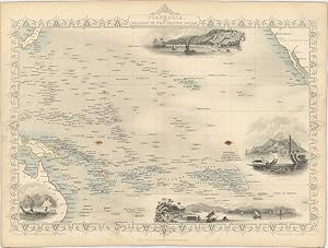
Polynesia, or the Islands in the Pacific Ocean.
Edité par London & New YorkJohn Tallis & Company -1856., 1851
Vendeur : Robert Frew Ltd. ABA ILAB, London, Royaume-Uni
Membre d'association : ABA ILAB PBFA
Evaluation du vendeur :
Carte
Original steel engraved map, with several vignette scenes showing Resolution Bay in the Marquesas, Kalakakooka in the Sandwich Islands, Dory in New Guinea and Ortaheite in the Society Islands. Decorative scrolling and title cartouche around the edges of the image. (Map 22 x 29.5 cm, overall sheet 27.5 x 36 cm). Original outline colour. Centrefold crease as issued. A few brown spots, otherwise good. For the Great Exhibition in 1851 John Tallis (1817-1876) worked with engraver John Rapkin (1815-1876) to publish the 'Illustrated World Atlas', whose maps were later re-issued by the London Printing and Publishing Company under the Tallis imprint. Their maps are prized for their wonderful steel-engraved vignettes showing the peoples, customs, architecture, landmarks, flora, and fauna of each country.
-
Falkland Islands and Patagonia.
Edité par The London Printing and Publishing Company -1856., 1851
Vendeur : Robert Frew Ltd. ABA ILAB, London, Royaume-Uni
Membre d'association : ABA ILAB PBFA
Evaluation du vendeur :
Carte
Two original steel engraved maps on one sheet. The upper showing the Falkland Islands, with vignette scenes of the Jason Islands and of Sea Eagles. The lower image showing Patagonia, with vignette scenes of Christmas Sound, Tierra Del Fuego and of "Fuegans." Decorative scrolling and title cartouche around the edges of the maps. (Map 22 x 29.5 cm, overall sheet 27.5 x 36 cm). Original outline colour. Centrefold crease as issued.5 One small brown spot, generally a very good copy. For the Great Exhibition in 1851 John Tallis (1817-1876) worked with engraver John Rapkin (1815-1876) to publish the 'Illustrated World Atlas', whose maps were later re-issued by the London Printing and Publishing Company. Their maps are prized for their wonderful steel-engraved vignettes showing the peoples, customs, architecture, landmarks, flora, and fauna of each country.
![Image du vendeur pour Independent Tartary [Antique Map] mis en vente par Books & Bidders Antiquarian Booksellers](https://pictures.abebooks.com/inventory/md/md31800635682.jpg)
![Image du vendeur pour New Zealand [Antique Map] mis en vente par Books & Bidders Antiquarian Booksellers](https://pictures.abebooks.com/inventory/md/md31800637588.jpg)

![Image du vendeur pour Part of South Australia [Antique Map] mis en vente par Books & Bidders Antiquarian Booksellers](https://pictures.abebooks.com/inventory/md/md31800023962.jpg)
![Image du vendeur pour Western Australia, Swan River [Antique Map] mis en vente par Books & Bidders Antiquarian Booksellers](https://pictures.abebooks.com/inventory/md/md31800025983.jpg)
![Image du vendeur pour Van Diemen's Island or Tasmania [Antique Map] mis en vente par Books & Bidders Antiquarian Booksellers](https://pictures.abebooks.com/inventory/md/md31800028796.jpg)
![Image du vendeur pour Polynesia, Islands in the Pacific Ocean [Antique Map] mis en vente par Books & Bidders Antiquarian Booksellers](https://pictures.abebooks.com/inventory/md/md31800038352.jpg)