Montant total (1 article articles) :
Destination de la commande :

keulen johannes gerard van (8 résultats)
Passer aux résultats principaux de la recherche
Type d'article
- Tous les types d'articles
- Livres (5)
- Magazines & Périodiques
- Bandes dessinées
- Partitions de musique
- Art, Affiches et Gravures (1)
- Photographies
- Cartes (2)
-
Manuscrits &
Papiers anciens
Etat
- Tous
- Neuf
- Ancien ou d'occasion
Reliure
Particularités
- Edition originale
- Signé
- Jaquette
- Avec images (4)
- Sans impression ŕ la demande
Pays
Evaluation du vendeur
-

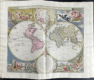
De Nieuve Groote Ligtende Zee-Fakkel.
Edité par 1969-1970, 1969
Vendeur : Berkelouw Rare Books, Berrima, NSW, Australie
Membre d'association : ANZAAB ILAB
Evaluation du vendeur :

Amsterdam 1716-1753. Reprinted, New York: Da Capo Press & Amsterdam: Theatrum Orbis Terrarum, (1969-1970). 6 parts in 3 vols. Elephant folio. Orig. cloth. Gilt. Spines uniformly gilt with raised bands and morocco titling-labels (slightly rubbed). With illusts., fold. map & charts some of which are coloured. Peel marks on end-papers. Complete and as new, albeit ex-library with stamps on edge of text-block. Lim. ed. of 500 numbered sets.
-
De nieuwe groote ligtende zee-fakkel: Amsterdam 1716-1753 (2 volumes)
Edité par Amsterdam : Theatrum Orbis Terrarum, 1969
Livre
Etat : Good. 2 (of 3) uniform gilt lettered brown leatherette volumes, (foldanle) maps in b/w, large folio. Limited edition of 500 numbered copies, however, this is an unnumbered copy.; Edges covers lsightly worn.
-
De Groote nieuwe vermeerderede Zee-Atlas ofte Water-Waereld. Frontispiece only. Very rare. Single leaf.
Edité par [Gerard van Keulen,] [1708]., [Amsterdam:], 1708
Vendeur : Dark Parks Books & Collectibles, Fallon, NV, Etats-Unis
Evaluation du vendeur :

Original frontispiece to the van Kuelen masterpiece sea-atlas De Groote Nieuwe Vermeerderede Zee-Atlas ofte Water-Waereld. Vertoonende in zig alle de Zee-kusten des Aardryks. [Amsterdam, 1708]. Leaf has been adhered at corners to another sheet. Trimmed at border line with some minor edge wear and soiling. Beautiful illustration and most suitable for framing. We find only one copy in reference, which was sold at Christie?s UK for over $200,000.00 at auction in May, 2022. The frontispiece is a match at all points, though trimmed and uncolored [the Christie?s copy full and in color]. ?The most complete sea-atlas by the Van Keulens, composed of nearly all the charts published up to the date 1709? [-Koeman].?The firm of van Keulen, active continuously from 1678 to 1885, was the largest private hydrographic chart-publishing agency in the world. Three generations of the family were active during the period when Amsterdam was at its height as a mercantile and shipping power. As a by-product of this, Amsterdam became the leading European centre of marine cartography, densely populated with the best chart-makers and publishers. Pre-eminent among these firms were the van Keulens who produced ?the largest and finest marine atlases in Holland? (Koeman). ?Johannes van Keulen (1654-1711) was the founder of the firm, enrolling in the booksellers? guild in Amsterdam in 1678. In 1680 he published the first part of his Zee-Atlas, by which the reputation of the firm was established. Although the family business was closely tied to maritime publications, Johannes himself was not a chart-maker, but simply an interested publisher. He was fortunate that, from the outset, he employed the skilled surveyor Claes Janszoon Vooght, who actually prepared the charts and also wrote the text. Over the years the Zee-Atlas was expanded to five parts, and it continued in print, in one form or another, until 1734. More ambitious, and with a far longer and more complicated history, was his pilot book, the Zee-Fakkel, which was first published in 1681-82, and continued in print to about 1800. The family also published books on every aspect of geography, navigation and nautical matters. Johannes?s son Gerard (c. 1678-1727) gradually succeeded him from about 1704. In contrast to his father, Gerard was a talented engraver, mathematician, and chart-maker, whose abilities were recognised when he was appointed Hydrographer to the Dutch East India Company in 1714. Under his guidance, the Zee-Atlas and Zee-Fakkel were greatly revised and improved, and many new charts introduced. After Gerard?s relatively early death in 1727, he was succeeded by his widow and later by his son Johannes II who is known in particular for publishing the sixth volume of the Zee-Fakkel ? this volume contained the previously secret cartography of the East India Archipelago.? [Christie?s lot 8, May 24, 2022].
-
De nieuwe groote lichtende Zee-Fakkel, van de geheele wereld: behelzende 't eerste, 't tweede, 't derde, 'tvierde, en vyfde deel : alwaar klaar en volkomen in vertoond werd, alle bekende zeekusten van de geheele wereld, . vergadert met groote kosten, en op het nieuw in beter order gesteld als voor deese, en verrykt met het vyfde of laatste deel, dat nooyt voor dese in 't licht is geweest / te samen gebracht door Claes Jansz. Vooght en Gerard van Keulen. [COMPLETE SET].
Vendeur : Antiquariaat A. Kok & Zn. B.V., Amsterdam, Pays-Bas
Membre d'association : ILAB NVVA
Evaluation du vendeur :
Amst., 1716-1753 [reprint Amst. & N.Y., 1969-1970]. 6 parts in 3 vols. [10],100,[50], [6],51,[43], [8],76,[16]pp., 252 (fold.) col. & b./w. maps. Dec. gilt tooled and raised imit. calf (rexine) bindings. Folio. - Spines damaged. along the extrimities; title vignets on spine sl. dam. (Theatrum Orbis Terrarum).Facsimile reprint of the edition Amst., 1716-1753, published in a limited edition of 500 numbered copies. With reprint of the text of the French edition (Amst., 1715) bound with at the end of the third volume. - - Complete set of 6 parts in three volumes: Part I: Vertoonende de zee-kusten van Holland . / vergadert door Claas Jansz. Voogt ; . met veele nieuwe kaarten . door Gerard van Keulen; part II: Verthoonende de zeekusten van het zuyderste gedeelte van de Noord-Zee . / verb. door Claas Jansz. Voogt ; en deze laatste druk vermeerdert en in 't ligt gebragt / door Joannes van Keulen; part III: Vertoonende de kusten van Granada . / verbetert door Claas Jansz. Voogt ; en deze laatste druk nieuwelyks verbeterd . door Gerard van Keulen; part IV: Verthoonende de zeekusten van Gujana . / door Claas Jansz. Vooght; part V: Vertoonende de zee-kusten van Guinea . / verbetert door Claes Jansz. Voogt ; en deze laatste druk nieuwelyks verb. . door Gerard van Keulen; part VI: Vertoonende de zeekusten, eylanden en havens van Oost-Indien . / alles . by eengebragt . door Jan de Marre ; met de nodige kaarten en landvertooningen verrykt en in 't licht gebragt door Joannes van Keulen.
-
Sterre Kaert of Hemels Pleyn, Waer Door Men Kanwetehoelaet Dat Hetis Overde Gehele Aertkloot, Op Alle Meridiane en Polus Hoogte, en, Opwat Lengte en Brete de Voorsz Sterre Staen, Bezuyde en Benoorde de Lini quinoctiael
Edité par Amsterdam, Reinier & Josua Ottens, 1750 circa, 1750
Vendeur : TABERNA LIBRARIA - ALAI - ILAB, Pistoia, Italie
Membre d'association : ALAI ILAB
Evaluation du vendeur :
Grande tavola incisa in rame, mm. 470x595 alla battuta (compresi margini bianchi mm. 540x625) impreziosita da coloritura coeva all'acquerello. Considerata una fra le tavole olandesi piů belle, di argomento astronomico. Incise le costellazioni settentrionali e gli emisferi meridionali in una sola proiezione. Le costellazioni sono raffigurate con i personaggi della mitologia classica, rappresentati come se guardassero la terra dall'alto, peraltro, con le loro schiene girate. Al margine inf. č presente una tabella di misurazioni organizzata in base ai segni zodiacali. Magnifica, antichi restauri al verso, nel punto di piega e una vecchia giunta in carta al margine inf. Molto rara.
-

Kolorierter Kupferstich - Afteekening van de Rivier of Haven van Calingfort - Yrland - Down County - Part of Dublin County in Irland - Dublin Harbor - Dublin Bay - Doppelkarte von Dublin und Carlingford - Irland. Seekarte.
Edité par Amsterdam ca 1750., 1750
Carte
ca 52 x 31 cm. Etat : Gut. Erstauflage, EA. 1 Blatt in sehr schönem Rahmen gerahmt hinter Glas mit Passepartout, ohne Rahmen ca 52 x 31 cm, miot Rahmen 81 x 63 cm, guter Zustand Sprache: Deutsch Gewicht in Gramm: 1100.
-
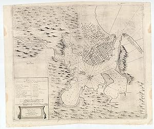
HAVANA, CUBA: De Stad en Haven van Havana op't E˙land Cuba met alle Desselfs Droogtens en Dieptens.
Edité par Amsterdam: Johannes van Keulen [Gerard Hulst van Keulen, circa ]., 1780
Vendeur : Antiquariat Dasa Pahor GbR, München, Allemagne
Membre d'association : ILAB VDA
Evaluation du vendeur :
Carte
Copper engraving, contemporary guard mounted to centrefold verso (Very Good, clean and attractive, just some stains in blank margins), 53 x 65 cm (21 x 25.5 inches). One of the rarest and most attractive of the great historical sea charts of Havana Harbour, and one which grants a fine rendering of the cityscape of what was then the New World s most sophisticated metropolis; first published in the mid-18th century by the eminent Amsterdam cartographer Johannes Van Keulen II, but here with the plate re-employed around 1780 by his son, Gerard Hulst van Keulen, the last major principal of the legendary Van Keulen publishing dynasty. - This very rare chart of Havana Harbour was first issued by Johannes van Keulen, the scion of the legendary Amsterdam chairmaking dynasty, around 1750, and was reissued (without changes to the plate) about three decades later by his son, Gerard Hulst van Keulen. One of the most attractive of historical charts of the subject, it provides a fine rendering of the city of Havana proper. Havana s stellar natural harbour is shown to expand into a great basin beyond its narrow mouth, which connect it to the Straits of Florida. The waters feature numerous bathymetric soundings, while the great walled city occupies the peninsula to the northwest of the port. Havana, founded in 1513, had for over two centuries been the great marshalling point for the Flotas, the annual fleets of Spanish galleons that carried vast quantities of silver and gold from South America and Mexico to Spain. This role, plus Cuba s immensely lucrative sugar-slave economy, had made Havana one of the wealthiest and arguably the most culturally sophisticated city in the New World. Its streets and great plazas were lined with immensely grand and elaborately decorative buildings that would have held pride of place in any European capital. The city of Havana is shown to be surrounded by its old walls and additionally defended by the immense fort of the Castillo de El Morro, at the western side of the moth of the harbour, while across is its sister bastion, the Castello de La Punta, while the Castello de La Fuerza protects Havana s quayside. Within the city, the key, in the lower left, employs letters to identify 22 sites, labelled (A-Z) with the first 16 entries on the list (A-Q) noting Havana s many grand ecclesiastical edifices, including A. Cathedral, as well as convents / monasteries and parish churches. Secular sites include the R. Audit Office (where gold and silver was inventoried!); S. St. Elmo s Redoubt; T. Infantry Barracks; X. Main City Gate; and Z. Abattoir. The surrounding countryside assumes a bucolic appearance, with rolling hills, forests and arroyos, punctuated by roads and the odd rural church. SEE OUR WEB PAGE FOR A LONGER DESCRIPTION.
-
Van Keulen's De Groote Nieuwe Vermeerderde Zee-Atlas ofte Water-Waerld - 183 Originally Hand-colored Maps or Charts
Date d'édition : 1708
Vendeur : Trillium Antique Prints & Rare Books, Franklin, TN, Etats-Unis
Evaluation du vendeur :
Art / Affiche / Gravure
Hardcover. Etat : Fine. This extraordinary and exceedingly rare atlas is from Johannes and Gerard Van Keulen and entitled in full "De Groote Nieuwe Vermeerderde Zee-Atlas ofte Water-Waerld. Vertoonende in zig alle de Zee-Kusten des Aardryks. Bestaande in zeer nette Kaarten, zo platte als wassende Graden: waar in ontdekt zyn alle Baayen, Reeden, Klippen, Droogtens, Dieptens, Anker-plaatzen, en alle Strekkingen en Opdoeningen van Landen: ook haar lengten en Polus hoogten, &c. Dienende tot Opbouwinge en Voortplantinge der Scheepvaart, uit nieuwe Opgevingen van Schippers, Stuurlieden en Liefhebbers der Zeevaart. Te zamen vergaadert en in â t ligt gebragt, door Gerard van Keulen, &c." The work was published in amsterdam by Gerard van Keulen in 1708 (but 1709). --- This was the largest Van Keulen sea atlas ever issued. Keulen atlases of this size are rarely available. The last notable records we see are Sotheby's in 1984 with 160 charts and Christie's in 2019 with 133 charts. --- Johannes van Keulen (1654-1711) was a Dutch publisher. He was said to have produced â the largest and finest marine atlases in Holland.â (Koeman) He received a privelege from the States General of Holland and West Friesland in order to printe maritame atlases and shipping guides. The privilege was to protect his printed material from illegal reproduction. He named his printing firm, In de Gekroonde Lootsman, which grew to be one of the most successful Amsterdam publishing firms. He collaborated with other cartographers including Claes Janszoon Vooght and Johannes van Luyken. --- Keulen's first atlas, entitled "Zee Atlas", contained only 40 charts. By 1695 his atlas would have 160 charts. His son, Gerard, took over publication in 1704 and expanded the atlas to 185 charts by 1709. --- Gerard van Keulen (1678-1727) was a skilled engraver, mathematician, and chart-maker. He was appointed Hydrographer to the Dutch East India Company in 1714. The van Keulen publishing firm operated continuously from 1678 to 1885 with three generations of the family active in the firm. --- The volume is bound in contemporary Dutch calf gilt, covers with a gilt stamped central armillary sphere within an arabesque, spine in compartments with raised bands gilt. --- Present in the atlas: 183 hand-colored engraved plates and charts (nearly all double-page or folding, with the world map credited to Nicolaes Visscher) 14 of which are coastal profiles, Hand-colored engraved allegorical title page or frontispiece dated 1709 (by Aernout Naghtegael after Jan Lukeyn), Folding letterpress title in Dutch dated 1708, Additional title in French dated 1709, 12 pages of Dutch text, 8 pages of French Text, 5 hand-colored allegorical divisional titles dated 1709. --- The contents collates broadly with Koeman Keu 28 (dated 1709 and containing 185 charts), with the following exceptions: the French letterpress title here is dated 1709 rather than 1707; in Part 2 charts (55)+(56) have been joined to form a large folding chart; charts (60) and (61) have been replaced by â Nouvelle carte marine Generale croissant ende-GrĂ s du Canal â ¦ A New General and Gradual increasing Compass Map of the Channel â ¦â ; chart (86) has been replaced with â Paskaert van Cales tot Cadiz â ¦â ; chart (97) has been replaced with â Pascaart van de kust van Portugalâ ; and there is an additional chart after (105) titled â Nieuwe Pascaert vande kust van Maroca en Zanhagaâ ; in Part 3 chart (111) has been updated with â Nieuwe paskaart van tâ opkomender Straat Gibralter â ¦â ; and two pairs of charts have been joined: (126)+(129), and (127)+(128) to form two large folding charts; and in Part 4 (136) has been replaced by â Paskaert waer in de graden der breedde over weder zyden â ¦â . The Dutch letterpress title is dated 1708 and contains the address of Gerard van Keulen, while the general allegorical title and 5 allegorical divisional titles are all dated 1709 and show the address of Johannes van Keulen. A further letterpress.