Montant total (1 article articles) :
Destination de la commande :

southern india de rapkin (18 résultats)
Passer aux résultats principaux de la recherche
Type d'article
- Tous les types d'articles
- Livres (9)
- Magazines & Périodiques
- Bandes dessinées
- Partitions de musique
- Art, Affiches et Gravures (1)
- Photographies
- Cartes (8)
-
Manuscrits &
Papiers anciens
Etat
- Tous
- Neuf
- Ancien ou d'occasion
Reliure
- Toutes
- Couverture rigide
- Couverture souple
Particularités
- Edition originale (1)
- Signé
- Jaquette
- Avec images (17)
- Sans impression ŕ la demande
Pays
Evaluation du vendeur
-
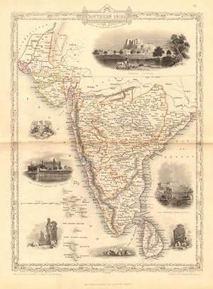
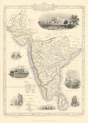
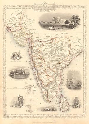
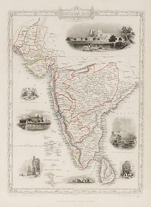
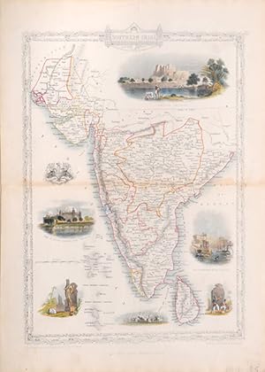
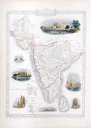
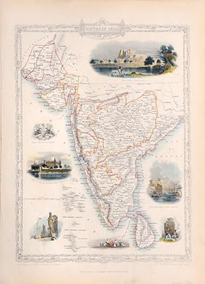
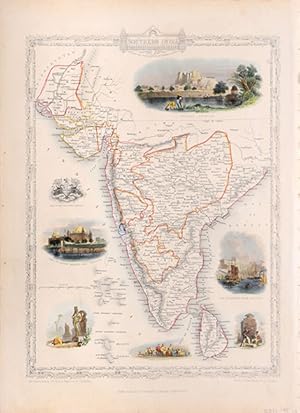
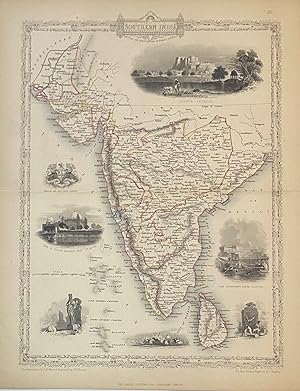
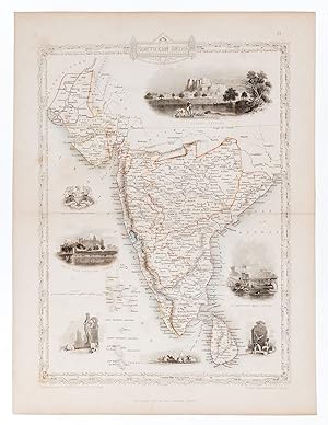
Etat : Good. SOUTHERN INDIA. Amber Fort, Jaipur & Gol Gumbaz, Bijapur.TALLIS/RAPKIN 1849 map. Antique engraved map by J Rapkin, published by John Tallis. Original outline hand colour, decorative border, and attractive inset vignette views; Map drawn and engraved by J. Rapkin; vignette illustrations drawn by AH Wray & engraved by JH Kernot. Published by John Tallis & Co (1849). 34.0 x 25.0cm, 13.5 x 9.75 inches; this is a folding map. Condition: Good. However, please note: The image shown may have been taken from a different example of this map than that which is offered for sale. The map you will receive is in good condition but there may be minor variations in the condition from that shown in the image which may include some light spotting. This map was coloured by hand at the time of publication, thus the colouration may vary slightly between different examples of the map; the colouring applied to the map you receive may differ slightly from that shown in the image. There is nothing printed on the reverse side, which is plain. Vignettes: Shuhur (The Amber Fort), Jeypoor (Jaipur); The Government House, Calcutta; Tomb of Sultan Mahomed Shah (Gol Gumbaz), Bejapoor (Bijapur); Seal of the East India Company. Ceylon, Laccadive & Maldive Islands are marked.
-
![Image du vendeur pour SOUTHERN INDIA: Including the Presidencies of Bombay & Madras. [A Map] mis en vente par RARE ORIENTAL BOOK CO., ABAA, ILAB](https://pictures.abebooks.com/inventory/md/md21618702521.jpg)
SOUTHERN INDIA: Including the Presidencies of Bombay & Madras. [A Map]
Vendeur : RARE ORIENTAL BOOK CO., ABAA, ILAB, Aptos, CA, Etats-Unis
Membre d'association : ABAA ILAB
Evaluation du vendeur :

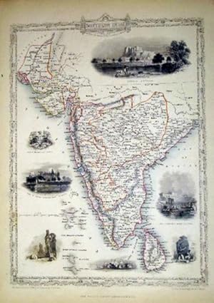
London [1851, Tallis]. A single sheet steel-engraved map, 30 x 23 cm., center folded, hand-colored outline, 7 decorative vignettes, verso blank, engraved by J. H. Kernot, illustra- tions by A. Wray, usual toning, else very good. The vignettes show:of Shuhur, Jeypoor; The Government House, Calcutta; Seal of the East India Company; Tomb of Sultan Mahomed Shah, Bejapoor; and others. This work shows all of India from Malwa South and the portion of Beloochistan South to Malwa and all of Celon. Nicely executed work, done for J. Tallis atlas. See: Tooley's Dicionary of Maps, S. 528. John Rapkin drew and engraved maps for Tallis 1841-1851. A color scan can be sent by email.
-
Southern India
Edité par The Illustrated Atlas and Modern History of the World Geographical, Political, Commercial & Statistical. John Tallis & Company. 1850, 1850
Vendeur : Peter Harrington. ABA/ ILAB., London, Royaume-Uni
Membre d'association : ABA ILAB PBFA
Evaluation du vendeur :

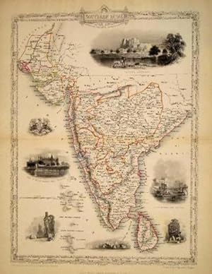
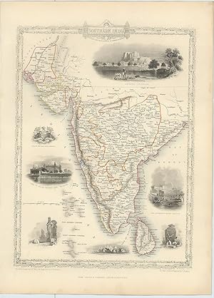
A Highly decorative map for the period with vignettes showing towns and local scenes, the whole enclosed in an elegant border Steel engraving. Original outline colour with later additions. In very good condition. Horizontal central crease. Size: 24 x 33 cm. (9˝ x 13 inches).
-

British India, Southern India; Steel Engraved Map
Edité par John Tallis & Company, London, 1851
Vendeur : Antiquarius Booksellers, Falkland, BC, Canada
Evaluation du vendeur :
Livre Edition originale
Disbound. Etat : VG+. John Rapkin - Engraver (illustrateur). First Edition. Decorative, steel engraved map with contemporary hand-coloured outlines of counties, routes, roads etc. From 'Tallis's Illustrated Atlas' of 1851 published in London at the time of the Great Exhibition. Engraved by John Rapkin. This map from a recently disbound Atlas. It is accompanied by the original two page printed description. Also available is a copy of the original title page of the Atlas from which this map was removed. The map illustrates Southern India from about the Tropic of Cancer south, and also includes the Sinde in the North and Ceylon in the South. Includes decorative vignettes of Shuhur Jeypoor, Government House Calcyya, Tomb of Sultan Mahomed Shah Bejapoor, plus, the Seal of the East India Company, worshipping an Idol and two British Soldiers! The map is very clean with no foxing, folds, creases, stains or marks. Paper still quite crisp. Adequate margins for matting all round. These are ORIGINAL maps, NOT reproductions. More information including an image is available on request.
-
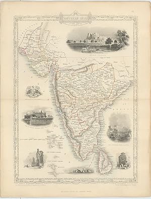
Etat : Good. SOUTHERN INDIA. Amber Fort, Jaipur & Gol Gumbaz, Bijapur.TALLIS/RAPKIN 1851 map. Antique engraved map by J Rapkin, published by John Tallis. Original outline hand colour, decorative border, and attractive inset vignette views; Map drawn and engraved by J. Rapkin; vignette illustrations drawn by AH Wray & engraved by JH Kernot. Published by John Tallis & Co (1851). 36.5 x 26.5cm, 14.5 x 10.25 inches. Condition: Good. The image shown may have been taken from a different example of this map than that which is offered for sale. The map you will receive is in good condition but there may be minor variations in the condition from that shown in the image. This map was coloured by hand at the time of publication, thus the colouration may vary slightly between different examples of the map; the colouring applied to the map you receive may differ slightly from that shown in the image. There is nothing printed on the reverse side, which is plain. Vignettes: Shuhur (The Amber Fort), Jeypoor (Jaipur); The Government House, Calcutta; Tomb of Sultan Mahomed Shah (Gol Gumbaz), Bejapoor (Bijapur); Seal of the East India Company. Ceylon, Laccadive & Maldive Islands.
-
Etat : Good. SOUTHERN INDIA. Amber Fort, Jaipur & Gol Gumbaz, Bijapur. RAPKIN/TALLIS 1851 map. Antique engraved map by J Rapkin, published by John Tallis. Original outline hand colour, decorative border, and attractive inset vignette views; Map drawn and engraved by J. Rapkin; vignette illustrations drawn by AH Wray & engraved by JH Kernot. Published by John Tallis & Co (1851). 36.5 x 26.5cm, 14.5 x 10.25 inches. Condition: Good. There is nothing printed on the reverse side, which is plain. Vignettes: Shuhur (The Amber Fort), Jeypoor (Jaipur); The Government House, Calcutta; Tomb of Sultan Mahomed Shah (Gol Gumbaz), Bejapoor (Bijapur); Seal of the East India Company. Ceylon, Laccadive & Maldive Islands.
-
Southern India
Edité par The Illustrated Atlas and Modern History of the World Geographical, Political, Commercial & Statistical. John Tallis & Company. 1850, 1850
Vendeur : Peter Harrington. ABA/ ILAB., London, Royaume-Uni
Membre d'association : ABA ILAB PBFA
Evaluation du vendeur :
A Highly decorative map for the period with vignettes showing towns and local scenes, the whole enclosed in an elegant border Steel engraving. Original colour with later additions. In fine condition. Size: 24 x 33 cm. (9˝ x 13 inches).
-
Southern India
Edité par The Illustrated Atlas and Modern History of the World Geographical, Political, Commercial & Statistical. John Tallis & Company. 1850, 1850
Vendeur : Peter Harrington. ABA/ ILAB., London, Royaume-Uni
Membre d'association : ABA ILAB PBFA
Evaluation du vendeur :
A Highly decorative map for the period with vignettes showing towns and local scenes, the whole enclosed in an elegant border Steel engraving. Original outline colour with later additions. In fine condition. Size: 24 x 33 cm. (9˝ x 13 inches).
-
Southern India
Edité par London Printing and Publishing Company, London, 1851
Vendeur : Argosy Book Store, ABAA, ILAB, New York, NY, Etats-Unis
Membre d'association : ABAA ILAB
Evaluation du vendeur :
unbound. Rapkin, J. (illustrateur). Map. Steel engraving with outline hand color. Page measures 14 3/4" x 10 5/8" Lovely map of Southern India from Sinde in Pakistan, the Rann of Kutch in the Thar desert, the Deccan Plateau and South to include Sri Lanka. Seven lovely engravings surround the map. Engraved by J. Rapkin, illustrations by A. H. Wray and engraved by J. H. Kernot. John Tallis Jr. (1817-1876) was a London born bookseller who continued the prolific map publishing company started by his father. After a partnership with his brother, Tallis Jr. expanded the business to New York in 1849 as well as Boston, Cincinnati, Rochester, Philadelphia and Baltimore.
-
Southern India, antique map with vignette views
Edité par John Tallis & Co., London, 1854
Vendeur : Antipodean Books, Maps & Prints, ABAA, Garrison, NY, Etats-Unis
Membre d'association : ABAA ANZAAB ESA ILAB
Evaluation du vendeur :

Maps. Steel engraved map from the famous Victorian publisher John Tallis, well-known for the attractive vignette views surrounding the maps, which illustrate the peoples & customs of that region. 10 x 13 1/2" plus margins. Attractive decorative border around edge, period outline color, very good condition.
-
Southern India, antique map with vignette views
Edité par John Tallis & Co., London, 1854
Vendeur : Antipodean Books, Maps & Prints, ABAA, Garrison, NY, Etats-Unis
Membre d'association : ABAA ANZAAB ESA ILAB
Evaluation du vendeur :
Maps. Steel engraved map from the famous Victorian publisher John Tallis, well-known for the attractive vignette views surrounding the maps, which illustrate the peoples & customs of that region. 10 x 13 1/2" plus margins. Attractive decorative border around edge, period outline color, very good condition.
-
Southern India.
Edité par London & New York John Tallis & Company., 1851
Vendeur : Robert Frew Ltd. ABA ILAB, London, Royaume-Uni
Membre d'association : ABA ILAB PBFA
Evaluation du vendeur :
Carte
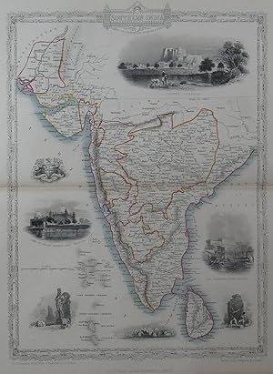
31 x 23 cm. Original outline colour. Steel engraved map. Several vignette scenes, including Shuhur, Jeypoor, Calcutta and Bejapoor. Decorative scrolling and title cartouche around the edges of the image. Generally very good, very occasional spotting outside margin not affecting image. For the Great Exhibition in 1851 John Tallis (1817-1876) worked with engraver John Rapkin (1815-1876) to publish the 'Illustrated World Atlas', whose maps were later re-issued by the London Printing and Publishing Company under the Tallis imprint. Their maps are prized for their wonderful steel-engraved vignettes showing the peoples, customs, architecture, landmarks, flora, and fauna of each country.
-
Southern India.
Edité par The London Printing and Publishing Company -1856., 1851
Vendeur : Robert Frew Ltd. ABA ILAB, London, Royaume-Uni
Membre d'association : ABA ILAB PBFA
Evaluation du vendeur :
Carte
Original steel engraved map of Southern India. Several vignette scenes, including Shuhur, Jeypoor, Calcutta and Bejapoor. Decorative scrolling and title cartouche around the edges of the image. (Map 22 x 29.5 cm, overall sheet 27.5 x 36 cm). Original outline colour. Centrefold crease as issued. Very good condition. For the Great Exhibition in 1851 John Tallis (1817-1876) worked with engraver John Rapkin (1815-1876) to publish the 'Illustrated World Atlas', whose maps were later re-issued by the London Printing and Publishing Company. Their maps are prized for their wonderful steel-engraved vignettes showing the peoples, customs, architecture, landmarks, flora, and fauna of each country.
-
Southern India.
Edité par London & New YorkJohn Tallis & Company -1856., 1851
Vendeur : Robert Frew Ltd. ABA ILAB, London, Royaume-Uni
Membre d'association : ABA ILAB PBFA
Evaluation du vendeur :
Carte
Original steel engraved map of Southern India. Several vignette scenes, including Shuhur, Jeypoor, Calcutta and Bejapoor. Decorative scrolling and title cartouche around the edges of the image. (Map 22 x 29.5 cm, overall sheet 27.5 x 36 cm). Original outline colour. In excellent condition. For the Great Exhibition in 1851 John Tallis (1817-1876) worked with engraver John Rapkin (1815-1876) to publish the 'Illustrated World Atlas', whose maps were later re-issued by the London Printing and Publishing Company. Their maps are prized for their wonderful steel-engraved vignettes showing the peoples, customs, architecture, landmarks, flora, and fauna of each country.
-
Southern India.
Edité par The London Printing and Publishing Company -1856., 1851
Vendeur : Robert Frew Ltd. ABA ILAB, London, Royaume-Uni
Membre d'association : ABA ILAB PBFA
Evaluation du vendeur :
Carte
Original steel engraved map of Southern India. Several vignette scenes by A.H. Wray, including Shuhur, Jeypoor, Calcutta and Bejapoor. Decorative scrolling and title cartouche around the edges of the image. (Map 22 x 29.5 cm, overall sheet 27.5 x 36 cm). Original outline colour. Centrefold crease as issued, an excellent copy. For the Great Exhibition in 1851 John Tallis (1817-1876) worked with engraver John Rapkin (1815-1876) to publish the 'Illustrated World Atlas', whose maps were later re-issued by the London Printing and Publishing Company. Their maps are prized for their wonderful steel-engraved vignettes showing the peoples, customs, architecture, landmarks, flora, and fauna of each country.
-
Southern India - Including the Presidencies of Bombay and Madras. With Vignettes of Shuhur, Jeypoor, The Government House, Calcutta, and Tomb of Sultan Mahomed Shah, Bejapoor. Also included are Depictions of European soldiers, natives at prayer and the Seal of the East India Company.
Edité par London, & New York, John Tallis & Company., 1851
Vendeur : Inanna Rare Books Ltd., Skibbereen, CORK, Irlande
Evaluation du vendeur :
Art / Affiche / Gravure
Original steel engraving / Vintage map. Drawn and engraved by John Rapkin. Partly hand-coloured. Illustrations by A.H. Wray and Engraved by J.H. Kernot. Plate Size: 31.8 cm x 25.5 cm. Sheet Size: 37.2 cm x 27.2 cm. Vintage 19th century map in very good condition. Beautiful map of the southern Indian subcontinent, from Sinde at the mouth of the Indus Estuary in the north down through Gujerat, Bejapor and Mysore and down into the Carnatic region in the south. Hydrabad and Circars border the Bay of Bengal. Ceylon is also included in the map as are the Laccadive and Maldive islands in the Indian Ocean. Relief is depicting with hachuring. The major cities such as Bombay, Sernigapatam, and Madras are shown, as are the rivers - including the Godavery and Beema rivers. This was an India dominated by the East India Company, the British joint-stock company that came to rule large areas of India with its private armies, exercising military power and seizing administrative functions. Formed in the early 1600s to compete with the Dutch for trade and commerce in the East, the company rose to account for half of the world's trade at one point. Company rule in India lasted until 1858, when, following the Indian Rebellion of 1857, the Government of India Act 1858 led to the British Crown's assuming direct control of the Indian subcontinent in the form of the new British Raj. The company was dissolved in 1874 as a result of the East India Stock Dividend Redemption Act passed one year earlier, as the Government of India Act had by then rendered it vestigial, powerless, and obsolete. The official government machinery of British India assumed the East India Company's governmental functions and absorbed its navy and its armies in 1858. (Wikipedia) John Tallis (7 November 1817 3 June 1876) was an English cartographic publisher. His company, John Tallis and Company, published views, maps and atlases in London from roughly 1838 to 1851. Tallis set up as a publisher with Frederick Tallis in Cripplegate in 1842; the business moved to Smithfield in 1846, and was dissolved in 1849. From 1851 to 1854 Tallis operated as John Tallis and Company. He started The illustrated news of the world and national portrait gallery of eminent personages in 1858, selling it for Ł1,370 in 1861; it folded in 1863. (Wikipedia) The most important project John Tallis undertook, was the 'Illustrated Atlas' from 1851. The original map we offer here, was part of this exceptional Atlas and all the maps it contained are still today considered as the last reminder of an era of lavish map production. Tallis worked the project together with John Rapkin (1815-1876) and it was Rapkin's style and talent that we have to thank for when we marvel at these maps today. What makes these maps so special is the detail of engraved vignettes that surround the map and often show indigenous scenes, people in their environment and even more so, historical buildings or historical views of towns and cities, architecture and landscape. The project of 'The Illustrated Atlas' was designed to be finished just in time for the anxiously awaited "Great Exhibition of the Works of Industry of All Nations" or The Great Exhibition, sometimes referred to as the Crystal Palace Exhibition in reference to the temporary structure in which it was held, was an international exhibition that took place in Hyde Park, London, from 1 May to 11 October 1851. It was the first in a series of World's Fairs, exhibitions of culture and industry that became popular in the 19th century, and it was a much anticipated event. The Great Exhibition was organized by Henry Cole and Prince Albert, husband of the reigning monarch, Queen Victoria. It was attended by numerous notable figures of the time, including Charles Darwin, Samuel Colt, members of the Orléanist Royal Family and the writers Charlotte Brontë, Charles Dickens, Lewis Carroll, George Eliot and Alfred Tennyson. Music for the opening was under the direction of Sir George Thomas Smart and the continuous music from the exhibited organs for the Queen's procession was "under the superintendence of William Sterndale Bennett". (Wikipedia) Sprache: english.
-
Southern India
Edité par John Tallis & Company, London & New York, 1849
Vendeur : Alexandre Antique Prints, Maps & Books, Toronto, ON, Canada
Membre d'association : ABAC ILAB
Evaluation du vendeur :
Carte
Etat : Very Good. A Charming 19th century depiction of Southern India. Vignettes surrounding the map are beautifully coloured., Size : 310x230 (mm), 12.25x9 (Inches), Original Outline Coloring.