
Montant total (1 article articles) :
Destination de la commande :

robert vaugondy giles (3 résultats)
Passer aux résultats principaux de la recherche
Type d'article
- Tous les types d'articles
- Livres (3)
- Magazines & Périodiques
- Bandes dessinées
- Partitions de musique
- Art, Affiches et Gravures
- Photographies
- Cartes
-
Manuscrits &
Papiers anciens
Etat
- Tous
- Neuf
- Ancien ou d'occasion
Reliure
- Toutes
- Couverture rigide (1)
- Couverture souple
Particularités
- Edition originale
- Signé
- Jaquette
- Avec images
- Sans impression ŕ la demande
Pays
Evaluation du vendeur
-
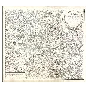
COMTES DE HAINAUT, ET DE CAMBRESIS, AVEC LES CONFINS DU COMTE DE FLANDRE, DU DUCHE DU BRABANT, DU COMTE DE NAMUR, ET UNE PARTIE DE LA SEIGNEURIE DE LIEGE. PAR LE SR. ROBERT GEOGRAPHE ORDINAIRE DU ROI. AVEC PRIVILEGE 1754.
Edité par Robert de Vaugondy., París, 1754
Vendeur : LIBRERIA ANTICUARIA MARGARITA DE DIOS, MADRID, Espagne
Membre d'association : LANCE
Evaluation du vendeur :

Etat : Bien. Autor: ROBERT DE VAUGONDY, Giles Descripción:Minucioso mapa realizado por Robert de Vaugondy. Gran detalle topográfico y toponímico de la región que actualmente forma parte de Francia y Bélgica. Bella cartela barroca para título y autores. Cartela en ángulo inferior izquierda para cuatro escalas. Color de época para demarcaciones territoriales. Técnica: Grabado calcográfico. Reverso: En blanco. Medidas: 490 x 550 mm 520 x 570 mm. Estado: Bien Otros datos: Autores: Robert de Vaugondy, Gilles, 1688-1766 , Robert de Vaugondy, Didier, 1723-1786. Notas: Interesante mapa del siglo XVIII para los conocedores de la región. RSS1.
-
Nouvelle Espagne, Nouveau Méxique, Isles Antilles. [Corrected by C. Lamarche]
Edité par Chez le Cen. Lamarche], [Paris, 1795
Vendeur : James Cummins Bookseller, ABAA, New York, NY, Etats-Unis
Membre d'association : ABAA ILAB
Evaluation du vendeur :
Engraved by E. Dussy. 1 vols. 12 1/8 x 9 3/8 inches (image). 1797 Map of America. Shows towns of Savannah, Charleston, Santa Fe, Albuquerque, Capes May, Henri, Hatteras, Fear and Carteret, and areas of Texas and Lower California. The territories of Nouveau Méxique, Louisiane, Floride and Nouvelle Angleterre are marked from the North American continent. Mexico, Central America and the upper portion of Columbia appear below with an inset of "Islae Acores ou Tercéres"Appears to be extracted from Robert de Vaugondy's "Nouvel Atlas portatif" with a manuscript notation "44" on verso. Double-page handcolored engraved map. Fold, some marginal tears, a few extending into image, coloring enhanced, some discoloration and staining Engraved by E. Dussy. 1 vols. 12 1/8 x 9 3/8 inches (image).
-
Nouvel Atlas Portatif destine principalement pour l'instruction de la Jeunesse.; [New Portable Atlas intended primarily for the instruction of Youth]
Edité par Delamarche, Paris, 1784
Vendeur : Argosy Book Store, ABAA, ILAB, New York, NY, Etats-Unis
Membre d'association : ABAA ILAB
Evaluation du vendeur :
hardcover. Etat : very good. Third. Illustrated with 52 fine double page copper plate maps with original hand outline color, plus a plate numbered 47(2). 7 pp. including table of contents. Beautifully engraved title page, has paper label torn off, and a stamp underneath. 4to (11.5" x 9.75"), minor scuffing to original marble board binding, with gilt and leather spine in 7 compartments. Many maps have paper and glue residue in margin (from early tab inserts?). Paris: 1784. Fine atlas including four world maps and several of the Americas (with a particularly nice map of Mexico) Europe, the Holy Land, Africa and Asia.
![Image du vendeur pour Nouvelle Espagne, Nouveau Méxique, Isles Antilles. [Corrected by C. Lamarche] mis en vente par James Cummins Bookseller, ABAA](https://pictures.abebooks.com/inventory/md/md2616621306.jpg)
![Image du vendeur pour Nouvel Atlas Portatif destine principalement pour l'instruction de la Jeunesse.; [New Portable Atlas intended primarily for the instruction of Youth] mis en vente par Argosy Book Store, ABAA, ILAB](https://pictures.abebooks.com/inventory/md/md2481896238.jpg)