


Ancienne Region des Sines
MANESSON-MALLET, Allain
Edité par Denys Thierry, Paris, 1683
Ancien(s) ou d'occasion
unbound
Vendeur
Argosy Book Store, ABAA, ILAB, New York, NY, Etats-Unis
Évaluation du vendeur 5 sur 5 étoiles
![]()
Honoris Librarius
Membre AbeBooks depuis 1996
Nous sommes désolés, cet exemplaire n'est plus disponible. Voici les résultats qui se rapprochent le plus pour Ancienne Region des Sines.
A propos de cet article
Description :
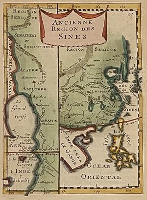
Miniature map. Engraving with hand coloring. Image measures 5 3/4" x 4". Sheet measures 8 1/4" x 5 1/2". This lovely miniature map of China is from the original French edition of Manesson-Mallet's "Description de L'Univers." It also depicts the Mughal Empire from the Himalayas to the Gulf of Bengal, and the Philippines are named 'Isles Barusses'. The map is in good condition with minor aging. Text on verso. Allain Manesson-Mallet (1630-1706) advanced from his position of musket bearer under Louis XIV to eventually occupy the position of "maitre de mathematiques" to the French King. He was the author and engraver of "Description de L'Univers," a five-volume survey of the world that included maps of the ancient and modern world, star maps, illustrations of flora and fauna, and information on the customs, religion and government of the many nations included in the text. When it was published, the text was the largest and most comprehensive work of its type. Intended to entertain its readers, Mallet's "Description" was a time capsule of the 17th-century world that captured and displayed it in all of its splendor. N° de réf. du vendeur 313675
Détails bibliographiques
Titre : Ancienne Region des Sines
Éditeur : Denys Thierry, Paris
Date d'édition : 1683
Reliure : unbound
Meilleurs résultats de recherche sur AbeBooks

Image fournie par le vendeur
"Ancienne Region des Sines" - China Chine
Edité par
Frankfurt am Main, 1685
Ancien ou d'occasion
Vendeur : Antiquariat Steffen Völkel GmbH, Seubersdorf, Allemagne
Évaluation du vendeur 5 sur 5 étoiles
![]()
Original Kupferstich von Alain Manesson Mallet (1630-1706) von 1685. -- Blatt-Maße: ca. 21 x 15 cm. -- im oberen Außenrand teils leicht fleckig, sonst gut erhalten. || Original copper engraving by Alain Manesson Mallet (1630-1706) from 1685. -- partly slighlty stained on the upper outer margin, otherwise in good condition. Sprache: Französisch Gewicht in Gramm: 10. N° de réf. du vendeur 273004
Quantité disponible : 1 disponible(s)
Image fournie par le vendeur
"Ancienne Region des Sines" - China Chine
Edité par
Paris, 1719
Ancien ou d'occasion
Vendeur : Antiquariat Steffen Völkel GmbH, Seubersdorf, Allemagne
Évaluation du vendeur 5 sur 5 étoiles
![]()
Original Kupferstich aus Alain Manesson Mallet's Atlas von 1719. -- Blatt-Maße: ca. 21,5 x 14 cm. -- im Außenrand leicht gebräunt, sonst gut erhalten. || Original copper engraving out Alain Manesson Mallet's atlas from 1719. -- slightly browned on the outer margin, otherwise in good condition. || Dies ist ein Original! - Kein Nachdruck! - Keine Kopie! -- This is an original! No copy! - No reprint! Sprache: Französisch Gewicht in Gramm: 10. N° de réf. du vendeur 264172
Quantité disponible : 1 disponible(s)
Image fournie par le vendeur
China Ancienne region des sines - Original Engraving Mallet - 1718
Ancien ou d'occasion
Vendeur : raremapexchange, Neuendettelsau, Allemagne
Évaluation du vendeur 5 sur 5 étoiles
![]()
Kein Einband. Etat : Gut. Orginal engraving from: Mallet: Beschreibung des gantzen Welt-Kreises. Published: 1718. Size: engraving is 14 x 10 cm plus white margins. Condition: please see photo. N° de réf. du vendeur ABE-1693227760999
Quantité disponible : 1 disponible(s)
Image fournie par le vendeur
Kupferstich- Karte, aus Mallet, "Die alte Landschaft der Sineser - Ancienne Region des Sines".
Ancien ou d'occasion
Vendeur : Antiquariat Clemens Paulusch GmbH, Berlin, Allemagne
Évaluation du vendeur 5 sur 5 étoiles
![]()
1719, 14,7 x 10,6 (H) Links eine Teilkarte mit dem indischen Golf. N° de réf. du vendeur 311987
Quantité disponible : 1 disponible(s)