


JOINT MAPS OF THE NORTHERN BOUNDARY OF THE UNITED STATES, FROM THE LAKE OF THE WOODS TO THE SUMMIT OF THE ROCKY MOUNTAINS
[Northwest Boundary Survey]
Edité par [N.p., 1872
Ancien(s) ou d'occasion
Vendeur
William Reese Company, New York, NY, Etats-Unis
Évaluation du vendeur 5 sur 5 étoiles
![]()
Vendeur AbeBooks depuis 13 juillet 2006
Nous sommes désolés, cet exemplaire spécifique n'est plus disponible. Voici nos correspondances les plus proches pour JOINT MAPS OF THE NORTHERN BOUNDARY OF THE UNITED STATES, FROM THE LAKE OF THE WOODS TO THE SUMMIT OF THE ROCKY MOUNTAINS de [Northwest Boundary Survey].
A propos de cet article
Description :
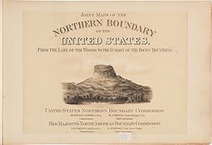
Twenty-three (of twenty-four) map leaves plus lithographic titlepage and index map. Oblong folio. Contemporary pebbled cloth, rebacked in black cloth. Hinges internally cracked, corners bumped. Ex-lib. with two library perforation stamps and two ink stamps. Titlepage reinforced at gutter. Internally quite clean. Lacks map 18, else good. An important atlas of the joint United States and Great Britain northern boundary survey. The fine lithographed maps detail the region surrounding the forty-ninth parallel. Archibald Campbell was commissioner of the United States organization, while D.R. Cameron headed the British crew. The maps begin in northern Minnesota and run west to the continental divide. N° de réf. du vendeur WRCAM17927
Détails bibliographiques
Titre : JOINT MAPS OF THE NORTHERN BOUNDARY OF THE ...
Éditeur : [N.p.
Date d'édition : 1872
Meilleurs résultats de recherche sur AbeBooks

JOINT MAPS OF THE NORTHERN BOUNDARY OF THE UNITED STATES, FROM THE LAKE OF THE WOODS TO THE SUMMIT OF THE ROCKY MOUNTAINS.
Edité par
[N.p. 1872]., 1872
Ancien ou d'occasion
Vendeur : William Reese Company, New York, NY, Etats-Unis
Évaluation du vendeur 5 sur 5 étoiles
![]()
An important atlas of the joint United States and Great Britain northern boundary survey. The fine lithographed maps detail the region surrounding the forty-ninth parallel. Archibald Campbell was commissioner of the United States organization, while D.R. Cameron headed the British crew. The maps begin in northern Minnesota and run west to the continental divide. Twenty-three (of twenty-four) map leaves plus lithographic titlepage and index map. Oblong folio. Contemporary pebbled cloth, rebacked in black cloth. Hinges internally cracked, corners bumped. Ex-lib. with two library perforation stamps and two ink stamps. Titlepage reinforced at gutter. Internally quite clean. Lacks map 18, else good. N° de réf. du vendeur 17927
Acheter D'occasion
EUR 655,84
Expédition ŕ EUR 11,89
Expédition nationale : Etats-Unis
Expédition nationale : Etats-Unis
Quantité disponible : 1 disponible(s)