

Map of Queens, New York
HAGSTROM COMPANY
Edité par Hagstrom Company, New York, 1961
Ancien(s) ou d'occasion
pamphlet
Vendeur
Argosy Book Store, ABAA, ILAB, New York, NY, Etats-Unis
Évaluation du vendeur 5 sur 5 étoiles
![]()
Honoris Librarius
Membre AbeBooks depuis 1996
Nous sommes désolés, cet exemplaire n'est plus disponible. Voici les résultats qui se rapprochent le plus pour Map of Queens, New York.
A propos de cet article
Description :
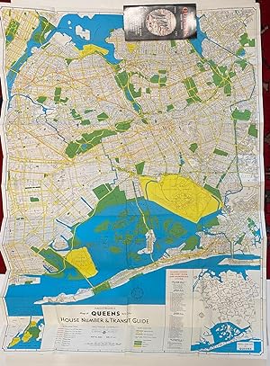
Map. Lithograph. Pamphlet measures 8 3/4" x 4 1/4". Map measures 31" x 44" Fantastic mid century folding map of Queens, New York. Pamphlet includes a 44 page street and postal index to the map. The map shows a House Number and Transit Guide, with an inset showing Postal Zone Map of the borough, and another inset depicting Greater New York. The map shows main auto routes, bus lines, railroads, and ferry routes. Street names, parks, cemeteries, beaches, and neighborhoods are labeled. The newly constructed BQE is indicated, set to open in 1963; New York International Airport, renamed JFK in 1963, is also highlighted with a detailed site plan. A fascinating depiction of New York City's largest borough, following decades of Robert Moses' influence on the city's urban development. Andrew Hagstrom founded Hagstrom Company in 1916, engaging in publishing and sale of regional, street, and road maps. N° de réf. du vendeur 316530
Détails bibliographiques
Titre : Map of Queens, New York
Éditeur : Hagstrom Company, New York
Date d'édition : 1961
Reliure : pamphlet