
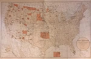
Map showing the location of the Indian Reservations within the limits of the United States and Territories
PRICE, Hiram
Edité par Department of the Interior, Washington, 1888
Ancien(s) ou d'occasion
unbound
Vendeur
Argosy Book Store, ABAA, ILAB, New York, NY, Etats-Unis
Évaluation du vendeur 5 sur 5 étoiles
![]()
Honoris Librarius
Membre AbeBooks depuis 1996
Nous sommes désolés, cet exemplaire n'est plus disponible. Voici les résultats qui se rapprochent le plus pour Map showing the location of the Indian Reservations within the limits of the United States and Territories.
A propos de cet article
Description :
Map. Color lithograph. Sheet measures 23.25" x 34.5". This large 1884 map presents the Indian Reservation in the United States and its territories. It covers the entire United States, with Alaska as an inset in lower left. Another inset shows the Indian Territory in northwest Oklahoma. The map identifies Indian Reservations and names. Military stations, Indian agencies, towns, villages, cities, railroads, rivers, mountains, and other topographic features are also noted. Compiled under the direction of Hon. Hiram Price, Commissioner of Indian Affairs. The map was issued by the Department of the Interior. In good condition with wear along the original folds. Margins show damage with some verso repairs. N° de réf. du vendeur 272708
Détails bibliographiques
Titre : Map showing the location of the Indian ...
Éditeur : Department of the Interior, Washington
Date d'édition : 1888
Reliure : unbound
Meilleurs résultats de recherche sur AbeBooks

Image fournie par le vendeur
Map Showing the Location of the Indian Reservations Within the Limits of the United States and Territories - Documenting the 19th-century decline of Native American populations.
Ancien ou d'occasion
Vendeur : Curtis Wright Maps, Berwyn, IL, Etats-Unis
Évaluation du vendeur 4 sur 5 étoiles
![]()
Etat : Very Good. "The Bureau of Indian Affairs (BIA) has been tasked with the management and administration of land granted to Native Americans since its official inception in 1824. Originally created to control the system of factories and trading posts on the frontier, the bureau evolved into a role overseeing the removal of Indians to lands west of the Mississippi. The tragic and steady loss of those lands is displayed on maps issued by the BIA in the late 19th and early 20th centuries. This 1885 edition was drafted by Paul Brodie under the authority of John D.C. Atkins, Commissioner for Indian Affairs. It was lithographed by the Norris Peters Company in Washington, D.C. and published by the Government Printing Office for inclusion in a Congressional record. The image highlights the ever-shrinking Indian reservations with an orange hue, each distinctly labeled and outlined. Relevant infrastructure like Indian agencies, military outposts, and railroads are noted according to the legend in the lower left. Inset maps (3 total) show sites in Alaska, the Mission Indian Reservations in California, and the northeastern tip of Indian Territory (soon to be open for white settlement). Example at the University of Oklahoma School of Law" Sheet Width (in) 35.25 Sheet Height (in) 24 Condition Description Color printed map on strong paper, formerly folded. Several clean splits along old folds have been repaired on the verso with archival tape. Moderate wrinkling and numerous small tears in the lower margin. Faint discoloration along folds and a bit of surface soiling and spotting, consistent with age. Good condition overall. N° de réf. du vendeur 7054
Acheter D'occasion
EUR 130,56
Expédition ŕ EUR 10,14
Expédition nationale : Etats-Unis
Expédition nationale : Etats-Unis
Quantité disponible : 1 disponible(s)