A NEW MAP OF THE STATE OF WISCONSIN
[Wisconsin]
Edité par Charles Desilver, Philadelphia, 1856
Ancien(s) ou d'occasion
Vendeur
William Reese Company, New York, NY, Etats-Unis
Évaluation du vendeur 4 sur 5 étoiles
![]()
Vendeur AbeBooks depuis 13 juillet 2006
Nous sommes désolés, cet exemplaire spécifique n'est plus disponible. Voici nos correspondances les plus proches pour A NEW MAP OF THE STATE OF WISCONSIN de [Wisconsin].
A propos de cet article
Description :
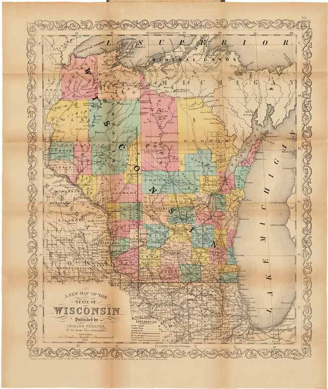
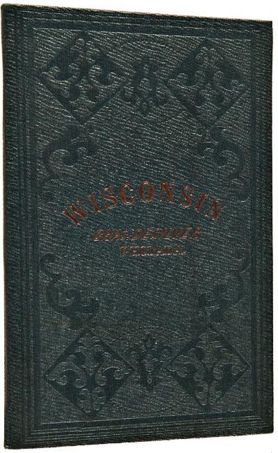
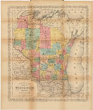
Pocket map, 17 1/2 x 14 1/2 inches, handcolored, folded to 5 1/2 x 3 1/2 inches. Original cloth folder, stamped in blind and gilt. Minor toning and soiling to map. Contemporary bookseller's label on front pastedown. Fine. A handsome and pristine copy of this scarce map of Wisconsin. The entirety of the state is handcolored, with each county delineated in a distinguishing color from its neighbors. Much of the northern portion of the state is empty at this point in time. The Chicago area and neighboring portion of southern Minnesota are also included. The front pastedown has a bookseller's label advertising "T.B. Peterson's Publishing and Bookselling Establishment, 102 Chesnut Street, Philadelphia." This label has been pasted over the printed endpaper advertising Desilver, and is likely where the map was originally sold. In beautiful condition, almost like new. N° de réf. du vendeur WRCAM48003
Détails bibliographiques
Titre : A NEW MAP OF THE STATE OF WISCONSIN
Éditeur : Charles Desilver, Philadelphia
Date d'édition : 1856
Meilleurs résultats de recherche sur AbeBooks

Image fournie par le vendeur
A NEW MAP OF THE STATE OF WISCONSIN.
Edité par
Philadelphia: Charles Desilver, 1856., 1856
Ancien ou d'occasion
Vendeur : William Reese Company, New York, NY, Etats-Unis
Évaluation du vendeur 4 sur 5 étoiles
![]()
A handsome and pristine copy of this scarce map of Wisconsin. The entirety of the state is handcolored, with each county delineated in a distinguishing color from its neighbors. Much of the northern portion of the state is empty at this point in time. The Chicago area and neighboring portion of southern Minnesota are also included. The front pastedown has a bookseller's label advertising "T.B. Peterson's Publishing and Bookselling Establishment, 102 Chesnut Street, Philadelphia." This label has been pasted over the printed endpaper advertising Desilver, and is likely where the map was originally sold. In beautiful condition, almost like new. Original cloth folder, stamped in blind and gilt. Minor toning and soiling to map. Contemporary bookseller's label on front pastedown. Fine. N° de réf. du vendeur 48003
Acheter D'occasion
EUR 567,66
Expédition ŕ EUR 11,87
Expédition nationale : Etats-Unis
Expédition nationale : Etats-Unis
Quantité disponible : 1 disponible(s)

A New Map of the State of Wisconsin.
Edité par
Charles Desilver,, Philadelphia:, 1857
Ancien ou d'occasion
Couverture rigide
Vendeur : Nicholas D. Riccio Rare Books, ABAA, Florham Park, NJ, Etats-Unis
Évaluation du vendeur 4 sur 5 étoiles
![]()
Hand colored folding map (450x380mm), folds into original 12mo gilt lettered cloth case. Some browning along folds, a couple of holes at folds, some aging and toning, case a little faded, but in nice shape; overall the map is very good. Relatively early map of Wisconsin, which became a state less than ten years earlier. Charles Desliver was the publisher, who was an active map publisher in the middle part of the 19th century. He was actually the partner in the Thomas Cowperthwait Company, and ended up purchasing some map copyrights from Mitchell. His business didn't have a lot of success, and he ended up selling the copyrights back to Mitchell. Nevertheless, this is a rather nice map, with a fair amount of detail in the lower portion of the state, and an attractive decorative boarder. geographicus website. N° de réf. du vendeur 100948
Acheter D'occasion
EUR 611,33
Expédition ŕ EUR 6,78
Expédition nationale : Etats-Unis
Expédition nationale : Etats-Unis
Quantité disponible : 1 disponible(s)