

Sumatra Taprobana map
Giovanni Battista Ramusio
Edité par Giovanni Battista Ramusio, n.p., 1560
Ancien(s) ou d'occasion
Disbound
Vendeur
Carydale Books, Rhinebeck, NY, Etats-Unis
Évaluation du vendeur 5 sur 5 étoiles
![]()
Vendeur AbeBooks depuis 14 janvier 2013
Nous sommes désolés, cet exemplaire n'est plus disponible. Voici les résultats qui se rapprochent le plus pour Sumatra Taprobana map.
A propos de cet article
Description :
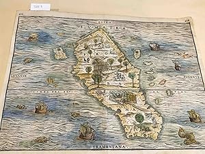
map area ca. 10.5"x 14.4" on paper sheet ca. 11.6" x 14.8" , paper age toned - early hand colored map of Sumatra- not dated but ca. 1560. It has clear evidence of a fold down the middle and two page numbers at the top left and right corners- 433- 434. Images of another copy appear to have slightly lower page numbers- suggesting this is from a later or earlier edition. The presence of the equator and the directions printed at top and bottom and left - right tell us the map is upside down compared to present day conventions. It is a bit odd that the Malay penninsula is not shown- as the scale is such that it seems as though it should be present. There are small images of people and animals working or resting on the island. Wonderrful images of ships and fish in the seas. Overall, good to very good copy. Due to size, this may be rolled and shipped in a tube - especially for international shipping. N° de réf. du vendeur 3803
Détails bibliographiques
Titre : Sumatra Taprobana map
Éditeur : Giovanni Battista Ramusio, n.p.
Date d'édition : 1560
Reliure : Disbound
Etat : Good +
Etat de la jaquette : No Jacket