A propos de cet article
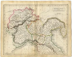
circa 1820s Coloured Map Engraving - CLOSE UP TO SHOW LOVELY DETAIL BY DR. SAMUEL BUTLER, D.D. - Engraved by Sidney Hall Published by Longman, Rees, Orme, Brown & Green, Paternoster Row THIS IS A GENUINE ORIGINAL Historical MAP - BEAUTIFUL PIECE OF HISTORY WITH ORIGINAL OUTLINE COLORING OF BORDERS DR. SAMUEL BUTLER, D.D. (1774-1839) His 'Ancient Geography' was first published in circa.1822, and 'Modern Geography' was published in circa.1825. There were numerous editions published up to the 1820s, being continued by his son. Approximate Map Image Size: 7 X 9 1/2 inches Approximate Overall Size: 8 1/2 X 10 1/2 inches (21.5 x 26.5 cm) Map has a Centerfold General Information regarding ITALY: Officially Italian Republic, republic, S Europe. It borders on France in the northwest, the Ligurian Sea and the Tyrrhenian Sea in the west, the Ionian Sea in the south, the Adriatic Sea in the east, Slovenia in the northeast, and Austria and Switzerland in the north. The country includes the large Mediterranean islands of Sicily and Sardinia and several small islands, notably Elba , Capri , Ischia , and the Lipari Islands . Vatican City and San Marino are two independent enclaves on the Italian mainland. Rome is Italy's capital and largest city. About 75% of Italy is mountainous or hilly, and roughly 20% of the country is forested. There are narrow strips of low-lying land along the Adriatic coast and parts of the Tyrrhenian coast. In addition to Rome, other important cities include Milan , Naples , Turin , Genoa , Palermo , Bologna , Florence , Catania , Venice , Bari , Trieste , Messina , Verona , Padua , Cagliari , Taranto , Brescia , and Livorno . Northern Italy, made up largely of a vast plain that is contained by the Alps in the north and drained by the Po River and its tributaries, comprises the regions of Liguria , Piedmont , Valle d'Aosta, Lombardy , Trentino-Alto Adige , Venetia , Friuli-Venezia Giulia , and part of Emilia-Romagna (which extends into central Italy). It is the richest part of the country, with the best farmland, the chief port (Genoa), and the largest industrial centers. Northern Italy also has a flourishing tourist trade on the Italian Riviera, in the Alps (including the Dolomites), on the shores of its beautiful lakes (Lago Maggiore, Lake Como, and Lake Garda), and in Venice. Gran Paradiso, the highest peak wholly situated within Italy, rises in Valle d'Aosta. The Italian peninsula, bootlike in shape and traversed in its entire length by the Apennines (which continue on into Sicily), comprises central Italy ( Marche , Tuscany , Umbria , and Latium regions) and southern Italy ( Campania , Basilicata , Abruzzi , Molise , Calabria , and Apulia regions). Central Italy contains great historic and cultural centers such as Rome, Florence, Pisa , Siena , Perugia , Assisi , Urbino , Bologna, Ravenna , Rimini , Ferrara , and Parma . The major cities of S Italy, generally the poorest and least developed part of the country, include Naples, Bari, Brindisi , Foggia , and Taranto. General Information regarding SWITZERLAND: Switzerland borders on France in the west and southwest, with the Jura Mts. and the Lake of Geneva (traversed by the Rhône River) forming the frontier; in the north it is separated from Germany by the Rhine River and Lake Constance; its eastern neighbors are Austria and Liechtenstein; in the southeast and south it is divided from Italy by the Alpine crests, the Lake of Lugano, and Lago Maggiore. The federal capital is Bern, and the largest city is Zürich. Between the Jura and the Central Alps, which occupy the southern section (more than half) of the country, there is a long, relatively narrow plateau, crossed by the Aare River and containing the lakes of Neuchâtel and Zürich. Alpine communications are assured by numerous passes and by railroad tunnels, notably the Lötschberg, St. Gotthard, and Simplon. Switzerland consists of 26 federated states, of which 20 are called cantons and 6 are called half cantons.
N° de réf. du vendeur 11647
Contacter le vendeur
Signaler cet article

