
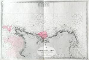
CAPE FLAMANVILLE TO ST. MARCOUF IS. . Detailed sea chart of Cherbourg harbour on the French north coast and its environs, compiled from the latest French Government Charts to 1921. First published by the Admiralty 1888 under the Superintendence of Captain W. J. L. Wharton, and now with small corrections by the
Admiralty Charts.
Edit� par Admiralty 1953
Carte
Etat : Occasion - Tr�s bon
Vendu par Garwood & Voigt, Sevenoaks, Royaume-Uni
Vendeur AbeBooks depuis 25 novembre 2013
�valuation du vendeur 5 sur 5 �toiles
![]()
Ancien(s) ou d'occasion
Etat : Occasion - Tr�s bon
Prix:
EUR 119,28
Autre devise
EUR 27,79
exp�dition depuis Royaume-Uni vers France
Destinations, frais et d�lais
Quantit� disponible : 1 disponible(s)
Ajouter au panier