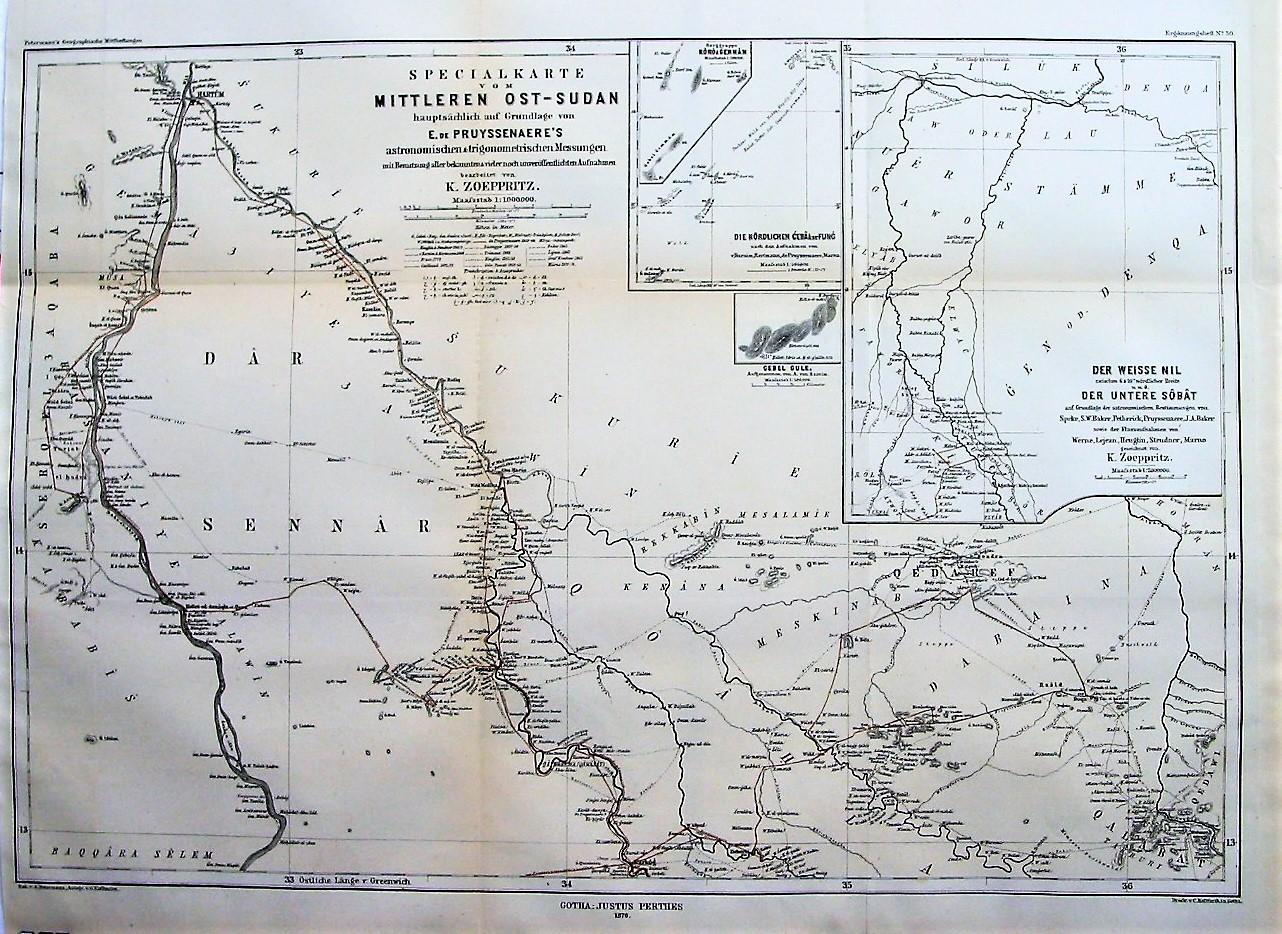
Thanks for shopping with Independent Books, Inc. We ship immediately when payments clear. Satisfaction is our hallmark - should you be dissatisfied with a book's condition, we will fully refund the cost of the book and shipping when it is received by us in the condition it was sent. If you purchase a book in error, we will gladly refund the cost of the book (but unfortunately, not shipping)when it is received by us in the condition it was sent. We accept major credit cards via ABE and Paypal, wh...
Si vous �tes un consommateur, vous pouvez vous r�tracter du pr�sent contrat dans les conditions indiqu�es ci-dessous. Etre un consommateur signifie �tre une personne physique qui agit � des fins qui n'entrent pas dans le cadre de son activit� commerciale, industrielle, artisanale ou lib�rale.
Informations standardis�es sur la r�tractation
Droit de r�tractation:
Vous avez le droit de vous r�tracter du pr�sent contrat sans donner de motif dans un d�lai de quatorze jours.
- Le d�lai de r�tractation expire quatorze jours apr�s le jour o� vous-m�me, ou un tiers autre que le transporteur et d�sign� par vous, prend physiquement possession du dernier bien, lot ou pi�ce.
Pour exercer le droit de r�tractation, vous devez nous Independent Books, 13508 Teal Lane, PO Box 426, 98631, Long Beach, Washington, U.S.A., 1 360.642.8561, notifier votre d�cision de r�tractation du pr�sent contrat au moyen d'une d�claration d�nu�e d'ambigu�t� (par exemple, lettre envoy�e par la poste, t�l�copie ou courrier �lectronique). Vous pouvez utiliser le mod�le de formulaire de r�tractation mais ce n'est pas obligatoire. Vous pouvez �galement remplir et transmettre une d�claration claire � cette fin sur notre site internet � �Vos commandes� dans �Votre compte�. Si vous utilisez cette option, nous vous enverrons sans d�lai un accus� de r�ception de la r�tractation sur un support durable (par exemple, par courriel).
Pour que le d�lai de r�tractation soit respect�, il suffit que vous transmettiez votre communication relative � l'exercice du droit de r�tractation avant l'expiration du d�lai de r�tractation.
Effets de la r�tractation :
En cas de r�tractation de votre part du pr�sent contrat, nous vous rembourserons tous les paiements re�us de vous, y compris les frais de livraison (� l'exception des frais suppl�mentaires d�coulant du fait que vous avez choisi, le cas �ch�ant, un mode de livraison autre que le mode moins co�teux de livraison standard propos� par nous) sans retard excessif et, en tout �tat de cause, au plus tard quatorze jours � compter du jour o� nous sommes inform�s de votre d�cision de r�tractation du pr�sent contrat. Nous proc�derons au remboursement en utilisant le m�me moyen de paiement que celui que vous aurez utilis� pour la transaction initiale, sauf si vous convenez express�ment d'un moyen diff�rent; en tout �tat de cause, ce remboursement n'occasionnera pas de frais pour vous.
Nous pouvons diff�rer le remboursement jusqu'� ce que nous ayons re�u le bien ou jusqu'� ce que vous ayez fourni une preuve d'exp�dition du bien, la date retenue �tant celle du premier de ces faits.
Vous devrez renvoyer ou rendre le bien, � Independent Books, 13508 Teal Lane, PO Box 426, 98631, Long Beach, Washington, U.S.A., 1 360.642.8561, sans retard excessif et, en tout �tat de cause, au plus tard quatorze jours apr�s que vous nous aurez communiqu� votre d�cision de r�tractation du pr�sent contrat. Ce d�lai est r�put� respect� si vous renvoyez le bien avant l'expiration du d�lai de quatorze jours. Vous devrez prendre en charge les frais directs de renvoi du bien. Votre responsabilit� n'est engag�e qu'� l'�gard de la d�pr�ciation du bien r�sultant de manipulations autres que celles n�cessaires pour �tablir la nature, les caract�ristiques et le bon fonctionnement de ce bien.
Exceptions au droit de r�tractation
Le droit de r�tractation ne s'applique pas � :
- la fourniture d'un contenu num�rique (dont livres �lectroniques) non fourni sur un support mat�riel (tel qu'un CD ou un DVD), si vous avez accept� au moment de la passation de votre commande que nous commencions la fourniture de celui-ci et renonc� � votre droit de r�tractation ;
- la fourniture d'un journal, d'un p�riodique ou d'un magazine, sauf pour les contrats d'abonnement � ces publications.
Formulaire de r�tractation
(A compl�ter et renvoyer seulement si vous souhaitez-vous r�tracter du pr�sent contrat)
A l'attention de : (Independent Books, 13508 Teal Lane, PO Box 426, 98631, Long Beach, Washington, U.S.A., 1 360.642.8561)
Je vous notifie par la pr�sente ma r�tractation du contrat portant sur la vente des produits suivants :
num�ro de commande :
Command� le/re�u le :
Mon nom et mon adresse :
Signature (seulement si ce formulaire est notifi� en version papier) :
Date
