


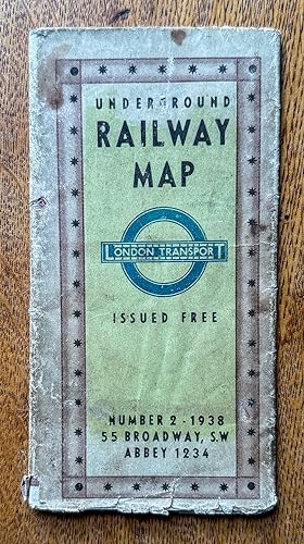
Underground Railway Map Number 2 -1938
Edité par Geographica Limited, London, 1938
Ancien(s) ou d'occasion
Soft cover
Vendeur
Garden City Books, Herts, Royaume-Uni
Évaluation du vendeur 5 sur 5 étoiles
![]()
Vendeur AbeBooks depuis 8 octobre 2007
Nous sommes désolés, cet exemplaire n'est plus disponible. Voici les résultats qui se rapprochent le plus pour Underground Railway Map Number 2 -1938.
A propos de cet article
Description :
vintage fold out paper map that shows the Underground in diagramatic form just prior to WW2. Lines shown are the Metropolitan & District, Picadilly, Bakerloo, Northern and Central. Catchment are covered includes Staines to the West, Hight Barnet to the North , Upney to the East and Mordon to the South. Rear shows blow up to central brown area, also map of theatres and cinemas.Condition: has a few large tears but not taped . Top margin has small stains but does not impinge on map. Would still look fantastic as a wall hanging. N° de réf. du vendeur 009798
Détails bibliographiques
Titre : Underground Railway Map Number 2 -1938
Éditeur : Geographica Limited, London
Date d'édition : 1938
Reliure : Soft cover
Etat : Good