A propos de cet article
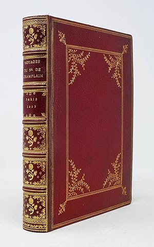
First edition. Paris: Chez Iean Berjon, 1613. Quarto (8 1/2" x 6 9/16", 216mm x 167mm). [Full collation available.] With 11 folding engraved plates (of which 8 are maps, of which 2 are facsimiles) plus 13 in-text engravings and 1 in-text woodcut. Bound in 1889 by W. Pratt for H. Stevens & Son in red morocco (rebacked, with the original backstrip laid down). On the covers, a triple gilt fillet border surrounding a triple-gilt fillet panel, with outside-corner gilt fleurons and inside-corner gilt branch-sprays. On the spine five raised bands with a gilt fillet. Gilt florals in the panels. Title gilt to the second panel, imprint gilt to the third panel. Five pairs of gilt fillets to the head- and tail-pieces. Double gilt fillet to the edges of the boards. Gilt inside dentelle. Marbled end-papers. All edges of the text-block gilt. Rebacked, with the original backstrip laid down. Fore-corners restored. Two maps (Burden 160 & 170) present only in facsimile. Evenly mildly tanned throughout. With a couple of early ink annotations to the dedicatory poem (?1r-v). Some scattered marginal repairs. A lovely copy in a sumptuous binding. Samuel de Champlain (1567-1635) was the great French navigator-explorer of Canada, founder of Quebec City and governor of Nouvelle France (the whole of the French colonial territory in America, less Acadia, Louisiana and the cities of Trois-Rivières and Montréal). The present item is the first published account of his voyage to and exploration of the northern part of France's vast American territory in the XVIIc, which would essentially collapse by 1763. Though Champlain would go on to traverse the Atlantic some two dozen times, here he includes accounts of his four voyages to America: 1604, 1610, 1611 and 1613. Champlain was, as Burden notes, "the first truly scientific cartographer of North America," and a crucial player in France's territorial expansion on the continent. Although one of the celebrated maps is in facsimile, the other vital map ("Carte geographique de la Novelle franse en sonaray meridien") is present in the second state, with the Ottawa River depicted (Burden 161). His maps are festooned with flora and fauna, indicating to France the limitless bounty of the New World; their aim is not just historical but political and persuasive. Church 360; Burden 161, 166-169, 171-181; Sabin 11835.
N° de réf. du vendeur 6JLR0124
Contacter le vendeur
Signaler cet article


