
Montant total (1 article articles) :
Destination de la commande :

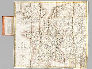
Cartes, histoire de france, Edition originale (86 rťsultats)
Commentaires
Passer aux rťsultats principaux de la recherche
Filtres de recherche
Type d'article
- Tous les types de produits
- Livres (21†283)
- Magazines & Pťriodiques (156)
- Bandes dessinťes (9)
- Partitions de musique (Aucun autre rťsultat ne correspond ŗ ces critŤres)
- Art, Affiches et Gravures (520)
- Photographies (9)
- Cartes (86)
- Manuscrits & Papiers anciens (51)
Etat
- Tous
- Neuf (Aucun autre rťsultat ne correspond ŗ ces critŤres)
- Ancien ou d'occasion (86)
Particularitťs
- Ed. originale (86)
- Signť (1)
- Jaquette (Aucun autre rťsultat ne correspond ŗ ces critŤres)
- Avec images (84)
- Sans impressions ŗ la demande (86)
Langue (2)
Livraison gratuite
Pays
Evaluation du vendeur
-
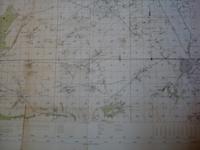
Carte De France Entoilťe , ST OMER . Section Sheet 27į S.E., de La 1į Guerre Mondiale ( Map of France of Sheet 27į S.E. For the First War )
Editť par Ordnance Survey, 1916
Langue: franÁais
Vendeur : Au vert paradis du livre, AUMES, LR, France
…valuation du vendeur 5 sur 5 ťtoiles

Carte Edition originale
EUR 50
Autre deviseEUR 5,60 expťdition depuis France vers Etats-UnisQuantitť disponible : 1 disponible(s)
Ajouter au panierCouverture souple. Etat : TrŤs bon. 1Ťre …dition. Carte entoilťe illustrťe . Plan de St Omer , Wisques , Quelmes , Acquin , forÍt national de Tournehem , Norbťcourt , Houlle , St Momelin au 1/20 000į en couleurs . L'entoilage ensanglantť par la blessure du soldat est imprimť d'un glossaire ( glossary ) franÁais-anglais . Quelques dťfauts d'usages que l'on pardonnera vues les conditions dans lesquelles cette guerre de tranchťes s'est dťroulťe . Histoire 1į Guerre Mondiale . - 1 p. , 250 gr.
-
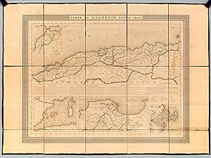
Carte de l'Algťrie Annťe 1844
Editť par Chez Hyacinthe Langlois, 1844
Langue: franÁais
Vendeur : Librairie du Cardinal, GRADIGNAN, France
…valuation du vendeur 5 sur 5 ťtoiles
Carte Edition originale
EUR 395
Autre deviseEUR 10 expťdition depuis France vers Etats-UnisQuantitť disponible : 1 disponible(s)
Ajouter au paniersouple. Etat : Bon. Carte dťpliante entoilťe format 79,5 x 58 cm, gravť par Dyonnet, Chez Hyacinthe Langlois, 4 rue du Pot de Feu St Sulpice, "Carte de France d'aprŤs Cassini", s.d. [ 1844 ] Jolie carte ancienne de l'Algťrie rehaussťe en couleurs. On y dťcouvre en encart les "Environs d'Alger" ou "l'Empire de Maroc". Bon ťtat (petit accroc en marge entoilťe, petits frott.) Langue: FranÁais.
-
Carte de France dressťe en 86 Dťpartemens, Avec les Prťfectures et Sous-Prťfectures, ArchevÍchťs, EvÍchťs, par Phťlipeau, 1821
Editť par Chez Basset, 1821
Langue: franÁais
Vendeur : Librairie du Cardinal, GRADIGNAN, France
…valuation du vendeur 5 sur 5 ťtoiles
Carte Edition originale
EUR 620
Autre deviseEUR 10 expťdition depuis France vers Etats-UnisQuantitť disponible : 1 disponible(s)
Ajouter au paniersouple. Etat : Bon. 1 carte dťpliante sous sa chemise cartonnťe d'origine, en 36 panneaux, format 78 x 67,5 cm, Chez Basset, Paris, 1821, limite des Dťpartements rehaussťes en couleurs Belle carte en trŤs bon ťtat (chemise un peu frottťe). Cette version de la carte de France de Phťlipeau, publiťe sous la Restauration, semble trŤs peu commune. Langue: FranÁais.
-
Plan de Bordeaux [ Gravure ancienne ]
Date d'ťdition : 1835
Langue: franÁais
Vendeur : Librairie du Cardinal, GRADIGNAN, France
…valuation du vendeur 5 sur 5 ťtoiles
Carte Edition originale
EUR 95
Autre deviseEUR 10 expťdition depuis France vers Etats-UnisQuantitť disponible : 1 disponible(s)
Ajouter au panierrigide. Etat : Bon. 1 gravure format 18,5 x 14 cm (ŗ vue) sous encadrement vitrť format 29 x 24, gravťe par Laguillermie et Ramboz, s.d. [ circa 1835 ] Jolie carte encadrťe de Bordeaux, extraite de la sťrie de la "France Pittoresque" publiťe par Abel Hugo en 1835. Bon ťtat (trŤs petits ťclats au cadre, trŤs bon ťtat par ailleurs). Langue: FranÁais.
-

Histoire de Kentucke, nouvelle colonie a l'ouest de la Virginie.
Editť par Paris: Buisson, 1785., 1785
Vendeur : Arader Galleries - AraderNYC, New York, NY, Etats-Unis
…valuation du vendeur 5 sur 5 ťtoiles
Carte Edition originale Signť
EUR 8†125,61
Autre deviseGratuit expťdition vers Etats-UnisQuantitť disponible : 1 disponible(s)
Ajouter au panierHardcover. Etat : Very Good. 1st Edition. 8vo., (7 7/8 x 4 5/8 inches). FINE large engraved folding map "Carte de Kentucke" by "Andre" after Filson, at end. Contemporary French mottled sheep, the smooth spine ruled in six compartments, gilt lettered in one, the others decorated with fine gilt tools (just a little rubbed). Provenance: with the signed bookplate of Bruce McKinney on the front paste-down, his sale, his sale 2nd December 2010, lot 118. THE FIRST BOOK DEVOTED TO KENTUCKY First French edition, first published in Wilmington Delaware the previous year, and without a map, which was published simultaneously and separately by Pursell and Rook of Philadelphia, and reprinted eight times between 1784-1793. The map in this volume was engraved and published in France. Filson arrived in Kentucky in 1783 and soon settled in Lexington, where he became a teacher and surveyor. "Relative peace had come to the Kentucky frontier in 1782 after the battle of Blue Licks, which in part diminished the omnipresent menace from Native Americans. Filson quickly seized on an idea to publish an account of the dramatic story of Kentucky's settlement and its natural history that would attract settlers and thereby increase the value of his landholdings. As he conducted land surveys and traveled throughout the central bluegrass region, he began intensively interviewing prominent frontiersmen such as Daniel Boone, James Harrod, and others about their Kentucky experiences" (Hay). "The Discovery, Settlement, and Present State of Kentucke, and an Essay towards the Topography and Natural History of That Important Country: To Which Is Added an Appendix" was the first written history of Kentucky, and because there were no printers in Kentucky, Filson traveled to Wilmington, Delaware, where James Adams printed it. "The main work consists of brief descriptive essays on topics such as the nature of the soil, discovery of Kentucky, air and climate, inhabitants, and rights of land (the three ways one can acquire land in Kentucky). Written in a vivid and colorful style with occasional factual errors, the book extolls the Eden-like qualities of Kentucky, an environment conducive to republican virtues and blessed with material riches. Aside from his personal observations, Filson cleverly used testimonies of leading Kentucky frontiersmen as endorsements in the book. The most important and enduring part of the volume, in the appendix, is "The Adventures of Colonel Daniel Boon," which traces the pioneer's life from the time he entered Kentucky in 1769 to 1784. Although written as an autobiography and signed by Boone, the pedantic writing style is clearly Filson's. Readers in America and Europe eagerly read of Boone's heroic exploits as an advance agent of progress, a natural man, who tamed the rugged frontier for civilization, and Filson's book became a major vehicle in publicizing and stimulating migration to Kentucky. "While Adams was printing the book, Filson employed Philadelphia engraver Henry Pursell and printer Ternon Rook to produce a map Filson had drawn to encourage settlement of Kentucky. Composed primarily from secondhand accounts of Boone and other explorers and Filson's own knowledge of the region, the map is well drawn but not completely accurate. It depicts the state's rivers and creeks, mountains and hills, towns and forts, and canebrakes, and clearly marks the location of the land surveyor's office. As was the cartographer's intention, the map conveys a sense of civilization and progress" (Charles C. Hay for ADNB). Church 1212; Field 537; Howes F129; Jones 590; Littell 351; Sabin 24338. Catalogued by Kate Hunter. Signed by Author(s).
-
Carte des Lacs du Canada
Editť par Hydrographe de la Marine, Paris, 1744
Vendeur : Alexandre Antique Prints, Maps & Books, Toronto, ON, Canada
Membre d'association : ABAC ILAB
…valuation du vendeur 2 sur 5 ťtoiles

Carte Edition originale
EUR 1†715,41
Autre deviseEUR 5,26 expťdition depuis Canada vers Etats-UnisQuantitť disponible : 1 disponible(s)
Ajouter au panierEtat : Very Good. Important First edition of this map of the Great Lakes. It was published in " Histoire et Description Generale de la Nouvelle France". "This map, by the famous French map and chartmaker Jacques Nicolas Bellin, was published in 1744 in Fr Oierre Francois-Xavier de Charlevoix's "Histoire et Description Generale de la Nouvelle France", which is one of the best eighteenth-century descriptions and accounts of North America. Charlevoix traveled Canada in 1720 to inspect the Jesuit missions there. Her journeyed throughout New France and Louisiana and down to the Gulf of Mexico via the Illinois and Mississippi Rivers in 1721-1722. He described in his work the possibilities and great beauty of the land he saw, especially near Natchez, mentioning such products as cotton, indigo and tobacco. Bellin had access to official journals, sketches, maps and charts of the earlier explorers, using such sources with great care and discrimination to produce some of the finest mapping of French America available in the eighteenth century." Goss, Size : 292x455 (mm), 11.50x17.91 (Inches), Black & White, 0.
-
1765 Map Carte gťographique Atlas France Rťgions
Date d'ťdition : 1765
Vendeur : Librairie L'amour qui bouquine, ALISE SAINTE REINE, France
…valuation du vendeur 4 sur 5 ťtoiles

Carte Edition originale
EUR 220
Autre deviseEUR 13,50 expťdition depuis France vers Etats-UnisQuantitť disponible : 1 disponible(s)
Ajouter au panierPas de couverture. Etat : TrŤs bon. Edition originale. PHILIPPE de PRETOT (Etienne-Andrť). Carte Nouvelle de la France 1765 37 x 26 cm (carte) sur feuille 43 x 28,5 cm. Vallet grav. 1765 Belle carte de la France issue de l'atlas universel dirigť par Philippe de Prťtot des Acadťmies Royales des Sciences, belles-lettre et Arts d'Angers et de Rouen, Censeur Royal et professeur en histoire. Belle carte gťographique ancienne de la deuxiŤme moitiť du XVIIIe siŤcle, trŤs bien conservťe (pli central d'origine peu visible au recto) en partie aquarellťe ŗ l'ťpoque (cŰtes et limites de rťgions). Voir photos. Voir nos autres cartes gťographiques du XVIIIe siŤcle en vente dans notre boutique.
-

Esquisse des Opeerations du SieŐge de Charleston, Capitale de la Caroline Meeridionale, en 1780.
Date d'ťdition : 1787
Vendeur : Geographicus Rare Antique Maps, Brooklyn, NY, Etats-Unis
Membre d'association : ABAA ESA ILAB
…valuation du vendeur 5 sur 5 ťtoiles
Carte Edition originale
EUR 1†769,58
Autre deviseEUR 14,90 expťdition vers Etats-UnisQuantitť disponible : 1 disponible(s)
Ajouter au panierGood. Very close margins on top, left, and bottom. Closed tear extending 3 inches through text area in lower left quadrant expertly repaired on verso. Size 14.25 x 11.5 Inches. An excellent 1787 American Revolutionary War map of Charleston, South Carolina. The map illustrates the 1780 Siege of Charleston, a major American Revolutionary War (1775 - 1783) battle, and one of the most devastating American defeats of the war. A Closer Look The map covers the peninsular tip of Charleston and predates many of the landfills and expansions that followed as the city developed. The port is evident, as is the early grid structure. The Circular Congregational Church, which still stands and was built in 1695, is recognizable. Swampland is mapped to the west of the city, and farmland appears just north of the city's fortifications. A detailed alphabetic key situated in the lower left corner identifies 20 locations, including forts, artillery emplacements, and battle and siege lines occupied by the British Army. The number of cannons at each fort and emplacement is provided. The British fleet is illustrated in the Cooper River, with each ship identified by name and the number of cannons onboard. The Siege of Charleston The Siege of Charleston took place from April 1 to May 12, 1780, and represented a change in British strategy based on the belief of strong Loyalist sympathies in the South. In the North, the British campaign to invade the American colonies from Quebec ended in the surrender of John Burgoyne's army after the Battle of Saratoga (which led to France and Spain entering the war on the American side). The drive to capture Philadelphia (the Revolutionary capital) ended with a British retreat back to New York City. Over some six weeks, the British, under the command of General Sir Henry Clinton, outmaneuvered the Continental defenders led by General Benjamin Lincoln. The resulting Continental defeat and surrender was the Revolutionary War's greatest single troop loss. This was the largest surrender of an American force under arms until the Union surrendered at Harper's Ferry during the American Civil War (1861 - 1865). The surrender of Charleston also left no significant American army in the South. Publication History and Census This map was issued to accompany the 1787 first French edition of David Ramsay's (1747 - 1815) History of the Revolution of South-Carolina or, more properly, Histoire de la Revolution d'Amerique par rapport a la Caroline Meridionale . The French edition of Ramsay's history was issued 2 years after the English edition. The map, which was originally engraved by the Charleston engraver Thomas Abernethie, has here been re-engraved in French by Charles Picquet. While cartographically similar, Piquet's engraving is more sophisticated and refined. This is one of the earliest obtainable maps of Charleston and is rare on the market. References: OCLC 494256020. Nebenzahl (Biblio) #84.
-
![Image du vendeur pour Plan D'York en Virginie avec les attaques et les Campemens de l'Armee combinee de France et d'Amerique. [Battle of Yorktown] mis en vente par Geographicus Rare Antique Maps](https://pictures.abebooks.com/inventory/md/md32068516359.jpg)
Plan D'York en Virginie avec les attaques et les Campemens de l'Armee combinee de France et d'Amerique. [Battle of Yorktown]
Date d'ťdition : 1787
Vendeur : Geographicus Rare Antique Maps, Brooklyn, NY, Etats-Unis
Membre d'association : ABAA ESA ILAB
…valuation du vendeur 5 sur 5 ťtoiles
Carte Edition originale
EUR 1†213,42
Autre deviseEUR 14,90 expťdition vers Etats-UnisQuantitť disponible : 1 disponible(s)
Ajouter au panierVery good. Size 11.25 x 15.25 Inches. An important 1787 American Revolutionary War map by F. Soul√ s illustrating the Battle of Yorktown, the last major conflict of the war. A Closer Look The map centers on the battleground just south of Yorktown on the shores of the York River. Gloucester is apparent just across the river. Finely engraved detail is exhibited throughout with fields, swamps, roads, and houses noted. The map was most likely drawn by Querenet de la Combe, a French officer commanding the French Royal Corps of Engineers at the Siege of Yorktown. The Battle The Battle of Yorktown, also known as the Siege of Yorktown, was a decisive victory by a combined force of American Continental Army troops led by General George Washington and French Army troops led by the Comte de Rochambeau over a British Army commanded by British lord and Lieutenant General Charles Cornwallis. The culmination of the Yorktown campaign, the siege proved to be the last major land battle of the American Revolutionary War in the North American theater, as the surrender by Cornwallis, and the capture of both him and his army, prompted the British government to negotiate an end to the conflict. Publication History and Census This map is based upon a 1781 French manuscript map housed in the Rochambeau Collection (Mss. 59) at the Library of Congress. It was issued in the second edition of Francois Soul√ s' Histoire des troubles de l'Amerique Anglais . The first edition, published in 1785 did not contain maps. Thomas Jefferson, after reading the 1785 edition, approached Soul√ s with suggestions for updates and revisions. He delivered his proposed corrections in 1786, in time for them to be incorporated into a new 1787 edition. The new version, with Jefferson's edits, was much improved with maps as well as a chapter on Jefferson's efforts to reform the laws of Virginia during the Revolution. The separate map is poorly represented in OCLC, but Soul√ s Histoire is well represented. References: Nebenzahl, K., A Bibliography of Printed Battle Plans of the American Revolution 1775-1795, 185. Verner, C., Maps of the Yorktown campaign, 1780-1781, XII. Phillips (Virginia) p. 61. Library of Congress, Rochambeau collection Mss. 59, G3884.Y6S3 1781 .Q41. OCLC 49048772. Cogliano, F. D., Thomas Jefferson: Reputation and Legacy, p. 45.
-
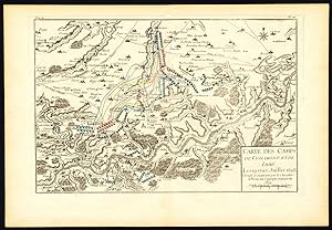
Antique Map-BATTLE-BELGIUM-HOEI-HUY-LESKY-VIGNAMONT-LUIK-LIEGE-Beaurain-1776
Vendeur : ThePrintsCollector, Zeeland, Pays-Bas
…valuation du vendeur 5 sur 5 ťtoiles
Carte Edition originale
EUR 111,50
Autre deviseEUR 18 expťdition depuis Pays-Bas vers Etats-UnisQuantitť disponible : 1 disponible(s)
Ajouter au panierTom. 4 Pl. 14: 'Carte des Camps de Vignamont et de Lesky les 19 et 25 Juillet 1693.' (Map of the Encampments of Vignamont and Lesky on July 19th and 25th 1693). This detailed map shows the region including Huy / Hoei, Warem, Liege /Luik in Belgium. Copperplate engraving on verge type hand laid paper. Original hand colouring of military sites. Watermark present. Blank rear. Authenticity guaranteed. Description: This decorative print originates from: 'Histoire Militaire de Flandre depuis l'Annee 1690. jusqu'en 1694 ‚¶' (transl.: Military history of Flanders from 1690-1694.), by le Chevalier de Beaurain, 2nd. ed. 1776 (first ed. 1756). This is an important historical source concerning the 'Nine Years' War' (1688-97). This war is often called the War of the Grand Alliance, the War of the Palatine Succession, or the War of the League of Augsburg ‚" was a major war of the late 17th century fought between King Louis XIV of France, and a European-wide coalition, the Grand Alliance, led by the Anglo-Dutch Stadtholder-King William III, Holy Roman Emperor Leopold I, King Charles II of Spain, Victor Amadeus II of Savoy, and the major and minor princes of the Holy Roman Empire.Artists and Engravers: Jean de Beaurain (1696-1771), was a French Geographer and Royal Geographer to King Louis XV. He published a 14-volume atlas (Atlas de g√ ographie ancienne et moderne.) and this work originally published in 1756. His son Jean-Baptiste Jacques de Beaurain (1728-unknown) continued his work on military history and finished some of his works. This plate is engraved by J. N. Martinet, text by J. Oger. Condition: Excellent. General age related toning. Some light shop soiling and ink ghosting. Rear blank. Please study scans carefully. Storage location: B44-06 The overall size is ca. 21.3 x 14.8 inch. The image size is ca. 17.3 x 11.6 inch. The overall size is ca. 54 x 37.5 cm. The image size is ca. 44 x 29.5 cm.
-

Antique Map-BATTLE-JEUMONT-SAMBRE-MAUBEUGE-QUEVY-FRANCE-BELGIUM-Beaurain-1776
Vendeur : ThePrintsCollector, Zeeland, Pays-Bas
…valuation du vendeur 5 sur 5 ťtoiles
Carte Edition originale
EUR 111,50
Autre deviseEUR 18 expťdition depuis Pays-Bas vers Etats-UnisQuantitť disponible : 1 disponible(s)
Ajouter au panierTom. 1 Pl. 11: 'Carte des Camps de Quevy et de Jeumont le 22 et 23 Juin 1690.' (Map of the encampments of Quevy and Jeumont on June 22nd and 23rd 1690.) This detailed map shows the region north of the river Sambre on the French / Belgian border, on the left is the town of Maubeuge in France. Copperplate engraving on verge type hand laid paper. Original hand colouring of military sites. Watermark present. Blank rear. Authenticity guaranteed. Description: This decorative print originates from: 'Histoire Militaire de Flandre depuis l'Annee 1690. jusqu'en 1694 .' (transl.: Military history of Flanders from 1690-1694.), by le Chevalier de Beaurain, 2nd. ed. 1776 (first ed. 1756). This is an important historical source concerning the 'Nine Years' War' (1688-97). This war is often called the War of the Grand Alliance, the War of the Palatine Succession, or the War of the League of Augsburg - was a major war of the late 17th century fought between King Louis XIV of France, and a European-wide coalition, the Grand Alliance, led by the Anglo-Dutch Stadtholder-King William III, Holy Roman Emperor Leopold I, King Charles II of Spain, Victor Amadeus II of Savoy, and the major and minor princes of the Holy Roman Empire.Artists and Engravers: Jean de Beaurain (1696-1771), was a French Geographer and Royal Geographer to King Louis XV. He published a 14-volume atlas (Atlas de gťographie ancienne et moderne.) and this work originally published in 1756. His son Jean-Baptiste Jacques de Beaurain (1728-unknown) continued his work on military history and finished some of his works. This plate is engraved by J. N. Martinet, text by J. Oger. Condition: Excellent. General age related toning. Some light shop soiling and ink ghosting. Rear blank. Please study scans carefully. Storage location: B43-05 The overall size is ca. 21.3 x 14.8 inch. The image size is ca. 16.9 x 11.2 inch. The overall size is ca. 54 x 37.5 cm. The image size is ca. 43 x 28.5 cm.
-

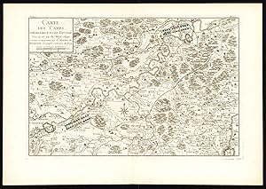
Antique Map-BATTLE-BELGIUM-NIVELLE-ZINNIK-MONS-SOIGNIES-Plate 27-Beaurain-1776
Vendeur : ThePrintsCollector, Zeeland, Pays-Bas
…valuation du vendeur 5 sur 5 ťtoiles
Carte Edition originale
EUR 111,50
Autre deviseEUR 18 expťdition depuis Pays-Bas vers Etats-UnisQuantitť disponible : 1 disponible(s)
Ajouter au panierTom. 4 Pl. 27: 'Carte des Camps de Nivelle et de Soignies les 18 et 20 Aoust 1693.' (Map of the Encampments of Nivelle and Soignies / Zinnik on August 18th and 20th 1693). This detailed map shows the region including Nivelle, Zinnik / Soignies, Mons / Bergen, Le Roeux, Braine de Comte in Belgium. Copperplate engraving on verge type hand laid paper. Original hand colouring of military sites. Watermark present. Blank rear. Authenticity guaranteed. Description: This decorative print originates from: 'Histoire Militaire de Flandre depuis l'Annee 1690. jusqu'en 1694 ‚¶' (transl.: Military history of Flanders from 1690-1694.), by le Chevalier de Beaurain, 2nd. ed. 1776 (first ed. 1756). This is an important historical source concerning the 'Nine Years' War' (1688-97). This war is often called the War of the Grand Alliance, the War of the Palatine Succession, or the War of the League of Augsburg ‚" was a major war of the late 17th century fought between King Louis XIV of France, and a European-wide coalition, the Grand Alliance, led by the Anglo-Dutch Stadtholder-King William III, Holy Roman Emperor Leopold I, King Charles II of Spain, Victor Amadeus II of Savoy, and the major and minor princes of the Holy Roman Empire.Artists and Engravers: Jean de Beaurain (1696-1771), was a French Geographer and Royal Geographer to King Louis XV. He published a 14-volume atlas (Atlas de g√ ographie ancienne et moderne.) and this work originally published in 1756. His son Jean-Baptiste Jacques de Beaurain (1728-unknown) continued his work on military history and finished some of his works. This plate is engraved by J. N. Martinet, text by J. Oger. Condition: Excellent. General age related toning. Some light shop soiling and ink ghosting. Rear blank. Please study scans carefully. Storage location: B44-12 The overall size is ca. 21.5 x 14.8 inch. The image size is ca. 20.1 x 9.1 inch. The overall size is ca. 54.5 x 37.5 cm. The image size is ca. 51 x 23 cm.
-

Antique Map-BATTLE-LONGCHAMPS-MOUSTIER-NAMUR-NAMEN-BELGIUM-BOSQUET-Beaurain-1776
Vendeur : ThePrintsCollector, Zeeland, Pays-Bas
…valuation du vendeur 5 sur 5 ťtoiles
Carte Edition originale
EUR 111,50
Autre deviseEUR 18 expťdition depuis Pays-Bas vers Etats-UnisQuantitť disponible : 1 disponible(s)
Ajouter au panierTom. 3 Pl. 12: 'Carte des Camps de Longchamp et de la Falise, du Bosquet et de Moustiers les 17, 20, 22 et 24e Juin 1692'. (Map of the encampments of Longchamps, Falize, Bosquet and Moustier on June 17th, 20th, 22nd and 24th 1692.) This detailed map shows the region west of Namur / Namen, with Gembloers and the river Meuse / Maas in Belgium. Copperplate engraving on verge type hand laid paper. Original hand colouring of military sites. Watermark present. Blank rear. Authenticity guaranteed. Description: This decorative print originates from: 'Histoire Militaire de Flandre depuis l'Annee 1690. jusqu'en 1694 ‚¶' (transl.: Military history of Flanders from 1690-1694.), by le Chevalier de Beaurain, 2nd. ed. 1776 (first ed. 1756). This is an important historical source concerning the 'Nine Years' War' (1688-97). This war is often called the War of the Grand Alliance, the War of the Palatine Succession, or the War of the League of Augsburg ‚" was a major war of the late 17th century fought between King Louis XIV of France, and a European-wide coalition, the Grand Alliance, led by the Anglo-Dutch Stadtholder-King William III, Holy Roman Emperor Leopold I, King Charles II of Spain, Victor Amadeus II of Savoy, and the major and minor princes of the Holy Roman Empire.Artists and Engravers: Jean de Beaurain (1696-1771), was a French Geographer and Royal Geographer to King Louis XV. He published a 14-volume atlas (Atlas de g√ ographie ancienne et moderne.) and this work originally published in 1756. His son Jean-Baptiste Jacques de Beaurain (1728-unknown) continued his work on military history and finished some of his works. This plate is engraved by J. N. Martinet, text by J. Oger. Condition: Excellent. General age related toning. Some light shop soiling and ink ghosting. Rear blank. Please study scans carefully. Storage location: B43-41 The overall size is ca. 14.8 x 21.3 inch. The image size is ca. 12.8 x 14 inch. The overall size is ca. 37.5 x 54 cm. The image size is ca. 32.5 x 35.5 cm.
-

Antique Map-BATTLE-BELGIUM-MONS-BERGEN-QUEVY-QUIEVRAIN-PERWEZ-Beaurain-1776
Vendeur : ThePrintsCollector, Zeeland, Pays-Bas
…valuation du vendeur 5 sur 5 ťtoiles
Carte Edition originale
EUR 111,50
Autre deviseEUR 18 expťdition depuis Pays-Bas vers Etats-UnisQuantitť disponible : 1 disponible(s)
Ajouter au panierTom. 4 Pl. 32: 'Carte des Camps de Quevy de Bossu, de Kievrain et de Perwez les 13, 14 et 15 Octobre 1693.' (Map of the Encampments of Quevy, Boussu, Quievrain and Perwez / Perwijs on October 13th, 14th and 15th 1693). This detailed map shows the region including Mons / Bergen, Conde, Saint Guilain in Belgium. Copperplate engraving on verge type hand laid paper. Original hand colouring of military sites. Watermark present. Blank rear. Authenticity guaranteed. Description: This decorative print originates from: 'Histoire Militaire de Flandre depuis l'Annee 1690. jusqu'en 1694 ‚¶' (transl.: Military history of Flanders from 1690-1694.), by le Chevalier de Beaurain, 2nd. ed. 1776 (first ed. 1756). This is an important historical source concerning the 'Nine Years' War' (1688-97). This war is often called the War of the Grand Alliance, the War of the Palatine Succession, or the War of the League of Augsburg ‚" was a major war of the late 17th century fought between King Louis XIV of France, and a European-wide coalition, the Grand Alliance, led by the Anglo-Dutch Stadtholder-King William III, Holy Roman Emperor Leopold I, King Charles II of Spain, Victor Amadeus II of Savoy, and the major and minor princes of the Holy Roman Empire.Artists and Engravers: Jean de Beaurain (1696-1771), was a French Geographer and Royal Geographer to King Louis XV. He published a 14-volume atlas (Atlas de g√ ographie ancienne et moderne.) and this work originally published in 1756. His son Jean-Baptiste Jacques de Beaurain (1728-unknown) continued his work on military history and finished some of his works. This plate is engraved by J. N. Martinet, text by J. Oger. Condition: Excellent. General age related toning. Some light shop soiling and ink ghosting. Rear blank. Please study scans carefully. Storage location: B44-16 The overall size is ca. 21.5 x 14.8 inch. The image size is ca. 19.1 x 12 inch. The overall size is ca. 54.5 x 37.5 cm. The image size is ca. 48.5 x 30.5 cm.
-

Antique Map-BATTLE-BELGIUM-TOURNAI-COURTRAI-MENIN-KORTRIJK-Beaurain-1776
Vendeur : ThePrintsCollector, Zeeland, Pays-Bas
…valuation du vendeur 5 sur 5 ťtoiles
Carte Edition originale
EUR 111,50
Autre deviseEUR 18 expťdition depuis Pays-Bas vers Etats-UnisQuantitť disponible : 1 disponible(s)
Ajouter au panierTom. 3 Pl. 26bis: 'Carte des Camps de Courtray le 29 Aoust 1692'. (Map of the Encampment of Courtrai / Kortrijk on August 29th 1692). This detailed map shows the region including Menin, Tournai, Courtrai / Kortrijk in Belgium. Copperplate engraving on verge type hand laid paper. Original hand colouring of military sites. Watermark present. Blank rear. Authenticity guaranteed. Description: This decorative print originates from: 'Histoire Militaire de Flandre depuis l'Annee 1690. jusqu'en 1694 ‚¶' (transl.: Military history of Flanders from 1690-1694.), by le Chevalier de Beaurain, 2nd. ed. 1776 (first ed. 1756). This is an important historical source concerning the 'Nine Years' War' (1688-97). This war is often called the War of the Grand Alliance, the War of the Palatine Succession, or the War of the League of Augsburg ‚" was a major war of the late 17th century fought between King Louis XIV of France, and a European-wide coalition, the Grand Alliance, led by the Anglo-Dutch Stadtholder-King William III, Holy Roman Emperor Leopold I, King Charles II of Spain, Victor Amadeus II of Savoy, and the major and minor princes of the Holy Roman Empire.Artists and Engravers: Jean de Beaurain (1696-1771), was a French Geographer and Royal Geographer to King Louis XV. He published a 14-volume atlas (Atlas de g√ ographie ancienne et moderne.) and this work originally published in 1756. His son Jean-Baptiste Jacques de Beaurain (1728-unknown) continued his work on military history and finished some of his works. This plate is engraved by J. N. Martinet, text by J. Oger. Condition: Excellent. General age related toning. Some light shop soiling and ink ghosting. Rear blank. Please study scans carefully. Storage location: B43-47 The overall size is ca. 21.3 x 14.8 inch. The image size is ca. 13.6 x 12.6 inch. The overall size is ca. 54 x 37.5 cm. The image size is ca. 34.5 x 32 cm.
-

Antique Map-BATTLE-HEMPTINNE-PHILIPPEVILLE-CERFONTAINE-BELGIUM-Beaurain-1776
Vendeur : ThePrintsCollector, Zeeland, Pays-Bas
…valuation du vendeur 5 sur 5 ťtoiles
Carte Edition originale
EUR 111,50
Autre deviseEUR 18 expťdition depuis Pays-Bas vers Etats-UnisQuantitť disponible : 1 disponible(s)
Ajouter au panierTom. 2 Pl. 17: 'Carte des Camps d'Emptine et de Cerfontaine les 22 Juillet et 8 Aoust 1691 avec celuy des Ennemis a Tarsienne le 22 Juillet et a Ham sur Heure le 8 Aoust'. (Map of the encampments of Hemptinne and Cerfontaine on July 22nd and August 8th 1691 with the enemy encampments at Tarcienne on July 22nd and at Ham sur Heure on August 8th.) This detailed map shows the region of Philippeville, Florennes, Walcourt in Belgium. Copperplate engraving on verge type hand laid paper. Original hand colouring of military sites. Watermark present. Blank rear. Authenticity guaranteed. Description: This decorative print originates from: 'Histoire Militaire de Flandre depuis l'Annee 1690. jusqu'en 1694 .' (transl.: Military history of Flanders from 1690-1694.), by le Chevalier de Beaurain, 2nd. ed. 1776 (first ed. 1756). This is an important historical source concerning the 'Nine Years' War' (1688-97). This war is often called the War of the Grand Alliance, the War of the Palatine Succession, or the War of the League of Augsburg - was a major war of the late 17th century fought between King Louis XIV of France, and a European-wide coalition, the Grand Alliance, led by the Anglo-Dutch Stadtholder-King William III, Holy Roman Emperor Leopold I, King Charles II of Spain, Victor Amadeus II of Savoy, and the major and minor princes of the Holy Roman Empire.Artists and Engravers: Jean de Beaurain (1696-1771), was a French Geographer and Royal Geographer to King Louis XV. He published a 14-volume atlas (Atlas de gťographie ancienne et moderne.) and this work originally published in 1756. His son Jean-Baptiste Jacques de Beaurain (1728-unknown) continued his work on military history and finished some of his works. This plate is engraved by J. N. Martinet, text by J. Oger. Condition: Excellent. General age related toning. Some light shop soiling and ink ghosting. Rear blank. Please study scans carefully. Storage location: B43-25 The overall size is ca. 14.8 x 21.1 inch. The image size is ca. 16.3 x 12.2 inch. The overall size is ca. 37.5 x 53.5 cm. The image size is ca. 41.5 x 31 cm.
-

Antique Map-BATTLE-BELGIUM-NAMUR-NAMEN-VIGNAMONT-HOEI-HUY-DAUSOIR-Beaurain-1776
Vendeur : ThePrintsCollector, Zeeland, Pays-Bas
…valuation du vendeur 5 sur 5 ťtoiles
Carte Edition originale
EUR 111,50
Autre deviseEUR 18 expťdition depuis Pays-Bas vers Etats-UnisQuantitť disponible : 1 disponible(s)
Ajouter au panierTom. 5 Pl. 10: 'Carte des Camps de Vignamont le 24 Juillet et de la Halte a Dausoir le 18 Aoust 1694. Avec celuy des Ennemis au Mont St. Andre le 23 Juillet.' (Map of the encampments of Vignamont on July 24th and Dausoir on August 18th 1694. With the encampments of the enemy at Mont-Saint-Andre on July 23rd.). This detailed map shows the region including Huy / Hoei, Waremme, Tongres / Tongeren, Saint Trond / Sint-Truiden, Borgloon, Luik / Liege in Belgium. Copperplate engraving on verge type hand laid paper. Original hand colouring of military sites. Watermark present. Blank rear. Authenticity guaranteed. Description: This decorative print originates from: 'Histoire Militaire de Flandre depuis l'Annee 1690. jusqu'en 1694 ‚¶' (transl.: Military history of Flanders from 1690-1694.), by le Chevalier de Beaurain, 2nd. ed. 1776 (first ed. 1756). This is an important historical source concerning the 'Nine Years' War' (1688-97). This war is often called the War of the Grand Alliance, the War of the Palatine Succession, or the War of the League of Augsburg ‚" was a major war of the late 17th century fought between King Louis XIV of France, and a European-wide coalition, the Grand Alliance, led by the Anglo-Dutch Stadtholder-King William III, Holy Roman Emperor Leopold I, King Charles II of Spain, Victor Amadeus II of Savoy, and the major and minor princes of the Holy Roman Empire.Artists and Engravers: Jean de Beaurain (1696-1771), was a French Geographer and Royal Geographer to King Louis XV. He published a 14-volume atlas (Atlas de g√ ographie ancienne et moderne.) and this work originally published in 1756. His son Jean-Baptiste Jacques de Beaurain (1728-unknown) continued his work on military history and finished some of his works. This plate is engraved by J. N. Martinet, text by J. Oger. Condition: Excellent. General age related toning. Some light shop soiling and ink ghosting. Rear blank. Please study scans carefully. Paper loss at top margin. Storage location: B44-20 The overall size is ca. 21.7 x 14.8 inch. The image size is ca. 19.9 x 13.6 inch. The overall size is ca. 55 x 37.5 cm. The image size is ca. 50.5 x 34.5 cm.
-

Antique Map-BATTLE-TAISNIERES-QUIEVRAIN-HONS-MONS-FRANCE-BELGIUM-Beaurain-1776
Vendeur : ThePrintsCollector, Zeeland, Pays-Bas
…valuation du vendeur 5 sur 5 ťtoiles
Carte Edition originale
EUR 111,50
Autre deviseEUR 18 expťdition depuis Pays-Bas vers Etats-UnisQuantitť disponible : 1 disponible(s)
Ajouter au panierTom. 1 Pl. 24: 'Carte des Camps de Quievrain de Hons ou de Taisnieres les 21 Juillet et 5 Aout 1690.' (Map of the Encampments of Quievrain, Hons or Taisnieres on July 21st and August 5th 1690.) This detailed map shows the region west of Maubeuge and Mons in the Belgian / French border region. Copperplate engraving on verge type hand laid paper. Original hand colouring of military sites. Watermark present. Blank rear. Authenticity guaranteed. Description: This decorative print originates from: 'Histoire Militaire de Flandre depuis l'Annee 1690. jusqu'en 1694 .' (transl.: Military history of Flanders from 1690-1694.), by le Chevalier de Beaurain, 2nd. ed. 1776 (first ed. 1756). This is an important historical source concerning the 'Nine Years' War' (1688-97). This war is often called the War of the Grand Alliance, the War of the Palatine Succession, or the War of the League of Augsburg - was a major war of the late 17th century fought between King Louis XIV of France, and a European-wide coalition, the Grand Alliance, led by the Anglo-Dutch Stadtholder-King William III, Holy Roman Emperor Leopold I, King Charles II of Spain, Victor Amadeus II of Savoy, and the major and minor princes of the Holy Roman Empire.Artists and Engravers: Jean de Beaurain (1696-1771), was a French Geographer and Royal Geographer to King Louis XV. He published a 14-volume atlas (Atlas de gťographie ancienne et moderne.) and this work originally published in 1756. His son Jean-Baptiste Jacques de Beaurain (1728-unknown) continued his work on military history and finished some of his works. This plate is engraved by J. N. Martinet, text by J. Oger. Condition: Excellent. General age related toning. Some light shop soiling and ink ghosting. Rear blank. Please study scans carefully. Storage location: B43-12 The overall size is ca. 21.1 x 14.8 inch. The image size is ca. 15.4 x 12 inch. The overall size is ca. 53.5 x 37.5 cm. The image size is ca. 39 x 30.5 cm.
-

Antique Map-BATTLE-BELGIUM-BONEFFE-QUAREM-HUY-GELDENAKEN-BORGWORM-Beaurain-1776
Vendeur : ThePrintsCollector, Zeeland, Pays-Bas
…valuation du vendeur 5 sur 5 ťtoiles
Carte Edition originale
EUR 111,50
Autre deviseEUR 18 expťdition depuis Pays-Bas vers Etats-UnisQuantitť disponible : 1 disponible(s)
Ajouter au panierTom. 4 Pl. 24: 'Carte des Camps de Quarem et de Bonef les 2 et 15 Aoust 1693.' (Map of the Encampments of Quarem and Boneffe on August 2nd and 15th 1693). This detailed map shows the region including Borgworm / Waremme, Huy / Hoei, Geldenaken / Jodoigne in Belgium. Copperplate engraving on verge type hand laid paper. Original hand colouring of military sites. Watermark present. Blank rear. Authenticity guaranteed. Description: This decorative print originates from: 'Histoire Militaire de Flandre depuis l'Annee 1690. jusqu'en 1694 ‚¶' (transl.: Military history of Flanders from 1690-1694.), by le Chevalier de Beaurain, 2nd. ed. 1776 (first ed. 1756). This is an important historical source concerning the 'Nine Years' War' (1688-97). This war is often called the War of the Grand Alliance, the War of the Palatine Succession, or the War of the League of Augsburg ‚" was a major war of the late 17th century fought between King Louis XIV of France, and a European-wide coalition, the Grand Alliance, led by the Anglo-Dutch Stadtholder-King William III, Holy Roman Emperor Leopold I, King Charles II of Spain, Victor Amadeus II of Savoy, and the major and minor princes of the Holy Roman Empire.Artists and Engravers: Jean de Beaurain (1696-1771), was a French Geographer and Royal Geographer to King Louis XV. He published a 14-volume atlas (Atlas de g√ ographie ancienne et moderne.) and this work originally published in 1756. His son Jean-Baptiste Jacques de Beaurain (1728-unknown) continued his work on military history and finished some of his works. This plate is engraved by J. N. Martinet, text by J. Oger. Condition: Excellent. General age related toning. Some light shop soiling and ink ghosting. Rear blank. Please study scans carefully. Storage location: B44-10 The overall size is ca. 21.5 x 14.8 inch. The image size is ca. 17.5 x 11.4 inch. The overall size is ca. 54.5 x 37.5 cm. The image size is ca. 44.5 x 29 cm.
-

Antique Map-BATTLE-NAMUR-NAMEN-LONGCHAMPS-EMPTINNE-BELGIUM-Beaurain-1776
Vendeur : ThePrintsCollector, Zeeland, Pays-Bas
…valuation du vendeur 5 sur 5 ťtoiles
Carte Edition originale
EUR 111,50
Autre deviseEUR 18 expťdition depuis Pays-Bas vers Etats-UnisQuantitť disponible : 1 disponible(s)
Ajouter au panierTom. 3 Pl. 8: 'Carte des Camps de Longchamp et d'Emptine, le 3 et 6 Juin 1692'. (Map of the encampments of Longchamps and Emptinne on June 3rd and 6th 1692.) This detailed map shows the region north of Namur / Namen in Belgium. Copperplate engraving on verge type hand laid paper. Original hand colouring of military sites. Watermark present. Blank rear. Authenticity guaranteed. Description: This decorative print originates from: 'Histoire Militaire de Flandre depuis l'Annee 1690. jusqu'en 1694 .' (transl.: Military history of Flanders from 1690-1694.), by le Chevalier de Beaurain, 2nd. ed. 1776 (first ed. 1756). This is an important historical source concerning the 'Nine Years' War' (1688-97). This war is often called the War of the Grand Alliance, the War of the Palatine Succession, or the War of the League of Augsburg - was a major war of the late 17th century fought between King Louis XIV of France, and a European-wide coalition, the Grand Alliance, led by the Anglo-Dutch Stadtholder-King William III, Holy Roman Emperor Leopold I, King Charles II of Spain, Victor Amadeus II of Savoy, and the major and minor princes of the Holy Roman Empire.Artists and Engravers: Jean de Beaurain (1696-1771), was a French Geographer and Royal Geographer to King Louis XV. He published a 14-volume atlas (Atlas de gťographie ancienne et moderne.) and this work originally published in 1756. His son Jean-Baptiste Jacques de Beaurain (1728-unknown) continued his work on military history and finished some of his works. This plate is engraved by J. N. Martinet, text by J. Oger. Condition: Excellent. General age related toning. Some light shop soiling and ink ghosting. Rear blank. Please study scans carefully. Storage location: B43-38 The overall size is ca. 21.5 x 14.8 inch. The image size is ca. 15 x 10.2 inch. The overall size is ca. 54.5 x 37.5 cm. The image size is ca. 38 x 26 cm.
-

Antique Map-BATTLE-LE POMMEREUIL-MONS-QUEVY-FRANCE-BELGIUM-Beaurain-1776
Vendeur : ThePrintsCollector, Zeeland, Pays-Bas
…valuation du vendeur 5 sur 5 ťtoiles
Carte Edition originale
EUR 111,50
Autre deviseEUR 18 expťdition depuis Pays-Bas vers Etats-UnisQuantitť disponible : 1 disponible(s)
Ajouter au panierTom. 1 Pl. 10: 'Carte des Camps de Pomereuil et de Quevy le 20 et 22 Juin 1690.' (Map of the encampments of Le Pommereuil and Quevy on June 20th and 22th 1690.) This detailed map shows the region around Mons / Bergen, Belgium and the French border. Copperplate engraving on verge type hand laid paper. Original hand colouring of military sites. Watermark present. Blank rear. Authenticity guaranteed. Description: This decorative print originates from: 'Histoire Militaire de Flandre depuis l'Annee 1690. jusqu'en 1694 .' (transl.: Military history of Flanders from 1690-1694.), by le Chevalier de Beaurain, 2nd. ed. 1776 (first ed. 1756). This is an important historical source concerning the 'Nine Years' War' (1688-97). This war is often called the War of the Grand Alliance, the War of the Palatine Succession, or the War of the League of Augsburg - was a major war of the late 17th century fought between King Louis XIV of France, and a European-wide coalition, the Grand Alliance, led by the Anglo-Dutch Stadtholder-King William III, Holy Roman Emperor Leopold I, King Charles II of Spain, Victor Amadeus II of Savoy, and the major and minor princes of the Holy Roman Empire.Artists and Engravers: Jean de Beaurain (1696-1771), was a French Geographer and Royal Geographer to King Louis XV. He published a 14-volume atlas (Atlas de gťographie ancienne et moderne.) and this work originally published in 1756. His son Jean-Baptiste Jacques de Beaurain (1728-unknown) continued his work on military history and finished some of his works. This plate is engraved by J. N. Martinet, text by J. Oger. Condition: Excellent. General age related toning. Some light shop soiling and ink ghosting. Tear in bottom margin, backed and not effecting image. Rear blank. Please study scans carefully. Storage location: B43-05 The overall size is ca. 21.3 x 14.8 inch. The image size is ca. 16.9 x 11.2 inch. The overall size is ca. 54 x 37.5 cm. The image size is ca. 43 x 28.5 cm.
-

Antique Map-BATTLE-BELGIUM-WALEFFE-HUY-HOEI-WAREMME-BORGWORM-Beaurain-1776
Vendeur : ThePrintsCollector, Zeeland, Pays-Bas
…valuation du vendeur 5 sur 5 ťtoiles
Carte Edition originale
EUR 111,50
Autre deviseEUR 18 expťdition depuis Pays-Bas vers Etats-UnisQuantitť disponible : 1 disponible(s)
Ajouter au panierTom. 4 Pl. 12: 'Carte des Camps de Walef St. Pierre et Walef St. Georges et de Vignamont les 18 et 19 Juillet 1693.' (Map of the Encampments of Waleffe and Vignamont on July 18th and 19th 1693). This detailed map shows the region including Warem, Huy / Hoei in Belgium. Copperplate engraving on verge type hand laid paper. Original hand colouring of military sites. Watermark present. Blank rear. Authenticity guaranteed. Description: This decorative print originates from: 'Histoire Militaire de Flandre depuis l'Annee 1690. jusqu'en 1694 ‚¶' (transl.: Military history of Flanders from 1690-1694.), by le Chevalier de Beaurain, 2nd. ed. 1776 (first ed. 1756). This is an important historical source concerning the 'Nine Years' War' (1688-97). This war is often called the War of the Grand Alliance, the War of the Palatine Succession, or the War of the League of Augsburg ‚" was a major war of the late 17th century fought between King Louis XIV of France, and a European-wide coalition, the Grand Alliance, led by the Anglo-Dutch Stadtholder-King William III, Holy Roman Emperor Leopold I, King Charles II of Spain, Victor Amadeus II of Savoy, and the major and minor princes of the Holy Roman Empire.Artists and Engravers: Jean de Beaurain (1696-1771), was a French Geographer and Royal Geographer to King Louis XV. He published a 14-volume atlas (Atlas de g√ ographie ancienne et moderne.) and this work originally published in 1756. His son Jean-Baptiste Jacques de Beaurain (1728-unknown) continued his work on military history and finished some of his works. This plate is engraved by J. N. Martinet, text by J. Oger. Condition: Excellent. General age related toning. Some light shop soiling and ink ghosting. Rear blank. Please study scans carefully. Storage location: B44-05 The overall size is ca. 21.3 x 14.8 inch. The image size is ca. 12.2 x 12 inch. The overall size is ca. 54 x 37.5 cm. The image size is ca. 31 x 30.5 cm.
-

Antique Map-BATTLE-BELGIUM-HOVE-HALLE-ENGHIEN-SOIGNIES-ZINNIK-Beaurain-1776
Vendeur : ThePrintsCollector, Zeeland, Pays-Bas
…valuation du vendeur 5 sur 5 ťtoiles
Carte Edition originale
EUR 111,50
Autre deviseEUR 18 expťdition depuis Pays-Bas vers Etats-UnisQuantitť disponible : 1 disponible(s)
Ajouter au panierTom. 3 Pl. 19: 'Carte des Camps de Soignies le 10 Juillet et De Hoves le 1er Aoust 1692. Avec celuy des Ennemis a Halle'. (Map of the encampments of Soignies / Zinnik on July 10th and Hove August 1st 1692. With the encampments of the enemy at Halle.) This detailed map shows the region including Zinnik / Soignies, Enghien, Halle, Braine le Comte in Belgium. Copperplate engraving on verge type hand laid paper. Original hand colouring of military sites. Watermark present. Blank rear. Authenticity guaranteed. Description: This decorative print originates from: 'Histoire Militaire de Flandre depuis l'Annee 1690. jusqu'en 1694 ‚¶' (transl.: Military history of Flanders from 1690-1694.), by le Chevalier de Beaurain, 2nd. ed. 1776 (first ed. 1756). This is an important historical source concerning the 'Nine Years' War' (1688-97). This war is often called the War of the Grand Alliance, the War of the Palatine Succession, or the War of the League of Augsburg ‚" was a major war of the late 17th century fought between King Louis XIV of France, and a European-wide coalition, the Grand Alliance, led by the Anglo-Dutch Stadtholder-King William III, Holy Roman Emperor Leopold I, King Charles II of Spain, Victor Amadeus II of Savoy, and the major and minor princes of the Holy Roman Empire.Artists and Engravers: Jean de Beaurain (1696-1771), was a French Geographer and Royal Geographer to King Louis XV. He published a 14-volume atlas (Atlas de g√ ographie ancienne et moderne.) and this work originally published in 1756. His son Jean-Baptiste Jacques de Beaurain (1728-unknown) continued his work on military history and finished some of his works. This plate is engraved by J. N. Martinet, text by J. Oger. Condition: Excellent. General age related toning. Some light shop soiling and ink ghosting. Rear blank. Please study scans carefully. Storage location: B43-44 The overall size is ca. 21.3 x 14.8 inch. The image size is ca. 11.8 x 11.8 inch. The overall size is ca. 54 x 37.5 cm. The image size is ca. 30 x 30 cm.
-

Antique Map-BATTLE-BELGIUM-FELUY-BASSY-NIVELLE-Beaurain-1776
Vendeur : ThePrintsCollector, Zeeland, Pays-Bas
…valuation du vendeur 5 sur 5 ťtoiles
Carte Edition originale
EUR 111,50
Autre deviseEUR 18 expťdition depuis Pays-Bas vers Etats-UnisQuantitť disponible : 1 disponible(s)
Ajouter au panierTom. 4 Pl. 3: 'Carte des Camps de Felluy et de Bassy le 3 et 6 de Juin 1693'. (Map of the Encampments of Feluy and Bassy on June 3rd and 6th 1693). This detailed map shows Nivelle and surroundings in Belgium. Copperplate engraving on verge type hand laid paper. Original hand colouring of military sites. Watermark present. Blank rear. Authenticity guaranteed. Description: This decorative print originates from: 'Histoire Militaire de Flandre depuis l'Annee 1690. jusqu'en 1694 ‚¶' (transl.: Military history of Flanders from 1690-1694.), by le Chevalier de Beaurain, 2nd. ed. 1776 (first ed. 1756). This is an important historical source concerning the 'Nine Years' War' (1688-97). This war is often called the War of the Grand Alliance, the War of the Palatine Succession, or the War of the League of Augsburg ‚" was a major war of the late 17th century fought between King Louis XIV of France, and a European-wide coalition, the Grand Alliance, led by the Anglo-Dutch Stadtholder-King William III, Holy Roman Emperor Leopold I, King Charles II of Spain, Victor Amadeus II of Savoy, and the major and minor princes of the Holy Roman Empire.Artists and Engravers: Jean de Beaurain (1696-1771), was a French Geographer and Royal Geographer to King Louis XV. He published a 14-volume atlas (Atlas de g√ ographie ancienne et moderne.) and this work originally published in 1756. His son Jean-Baptiste Jacques de Beaurain (1728-unknown) continued his work on military history and finished some of his works. This plate is engraved by J. N. Martinet, text by J. Oger. Condition: Excellent. General age related toning. Some light shop soiling and ink ghosting. Rear blank. Please study scans carefully. Storage location: B44-01 The overall size is ca. 21.3 x 14.8 inch. The image size is ca. 15.2 x 11.8 inch. The overall size is ca. 54 x 37.5 cm. The image size is ca. 38.5 x 30 cm.
-

Antique Map-BATTLE-HERINE-HAUTERIVE-TOURNAI-DOORNIK-LEUZE-BELGIUM-Beaurain-1776
Vendeur : ThePrintsCollector, Zeeland, Pays-Bas
…valuation du vendeur 5 sur 5 ťtoiles
Carte Edition originale
EUR 111,50
Autre deviseEUR 18 expťdition depuis Pays-Bas vers Etats-UnisQuantitť disponible : 1 disponible(s)
Ajouter au panierTom. 2 Pl. 30: 'Carte des Camps d'Herine et d'Hauterive les 18 et 24 Septembre 1691. Avec l'Aile droite de Cavalerie a l'Abbaye du Sauffoy les 18 et 21 apres le Combat de Leuse'. (Map of the encampments of Herine and Hauterive on September 18th and 24 th 1691. With the corridor of the cavalry at the Abbey of Sauffoy on September 18th and 21st after the battle of Leuze.) This detailed map shows theregion north of Tournai / Doornik in Belgium. Copperplate engraving on verge type hand laid paper. Original hand colouring of military sites. Watermark present. Blank rear. Authenticity guaranteed. Description: This decorative print originates from: 'Histoire Militaire de Flandre depuis l'Annee 1690. jusqu'en 1694 .' (transl.: Military history of Flanders from 1690-1694.), by le Chevalier de Beaurain, 2nd. ed. 1776 (first ed. 1756). This is an important historical source concerning the 'Nine Years' War' (1688-97). This war is often called the War of the Grand Alliance, the War of the Palatine Succession, or the War of the League of Augsburg - was a major war of the late 17th century fought between King Louis XIV of France, and a European-wide coalition, the Grand Alliance, led by the Anglo-Dutch Stadtholder-King William III, Holy Roman Emperor Leopold I, King Charles II of Spain, Victor Amadeus II of Savoy, and the major and minor princes of the Holy Roman Empire.Artists and Engravers: Jean de Beaurain (1696-1771), was a French Geographer and Royal Geographer to King Louis XV. He published a 14-volume atlas (Atlas de gťographie ancienne et moderne.) and this work originally published in 1756. His son Jean-Baptiste Jacques de Beaurain (1728-unknown) continued his work on military history and finished some of his works. This plate is engraved by J. N. Martinet, text by J. Oger. Condition: Excellent. General age related toning. Some light shop soiling and ink ghosting. Rear blank. Please study scans carefully. Storage location: B43-32 The overall size is ca. 14.8 x 21.1 inch. The image size is ca. 10.8 x 12.6 inch. The overall size is ca. 37.5 x 53.5 cm. The image size is ca. 27.5 x 32 cm.
-

Antique Map-BATTLE-BELGIUM-TOURNAI-DOORNIK-PERUWELZ-SAULSOY-Beaurain-1776
Vendeur : ThePrintsCollector, Zeeland, Pays-Bas
…valuation du vendeur 5 sur 5 ťtoiles
Carte Edition originale
EUR 111,50
Autre deviseEUR 18 expťdition depuis Pays-Bas vers Etats-UnisQuantitť disponible : 1 disponible(s)
Ajouter au panierTom. 4 Pl. 33: 'Carte des Camps de Peruwelz et de L' Abbaye de Saulsoy les 15 et 17 Octobre 1693.' (Map of the Encampments of Peruwelz and the Abbey of Saulsoy on October 15th and 17th 1693). This detailed map shows the region including Tournai / Doornik, in Belgium. Copperplate engraving on verge type hand laid paper. Original hand colouring of military sites. Watermark present. Blank rear. Authenticity guaranteed. Description: This decorative print originates from: 'Histoire Militaire de Flandre depuis l'Annee 1690. jusqu'en 1694 ‚¶' (transl.: Military history of Flanders from 1690-1694.), by le Chevalier de Beaurain, 2nd. ed. 1776 (first ed. 1756). This is an important historical source concerning the 'Nine Years' War' (1688-97). This war is often called the War of the Grand Alliance, the War of the Palatine Succession, or the War of the League of Augsburg ‚" was a major war of the late 17th century fought between King Louis XIV of France, and a European-wide coalition, the Grand Alliance, led by the Anglo-Dutch Stadtholder-King William III, Holy Roman Emperor Leopold I, King Charles II of Spain, Victor Amadeus II of Savoy, and the major and minor princes of the Holy Roman Empire.Artists and Engravers: Jean de Beaurain (1696-1771), was a French Geographer and Royal Geographer to King Louis XV. He published a 14-volume atlas (Atlas de g√ ographie ancienne et moderne.) and this work originally published in 1756. His son Jean-Baptiste Jacques de Beaurain (1728-unknown) continued his work on military history and finished some of his works. This plate is engraved by J. N. Martinet, text by J. Oger. Condition: Excellent. General age related toning. Some light shop soiling and ink ghosting. Rear blank. Please study scans carefully. Storage location: B44-16 The overall size is ca. 21.5 x 14.8 inch. The image size is ca. 12.2 x 12.6 inch. The overall size is ca. 54.5 x 37.5 cm. The image size is ca. 31 x 32 cm.
-

Antique Map-BATTLE-LEUZE EN HAINAUT-LE POMMEREUIL-FRANCE-BELGIUM-Beaurain-1776
Vendeur : ThePrintsCollector, Zeeland, Pays-Bas
…valuation du vendeur 5 sur 5 ťtoiles
Carte Edition originale
EUR 111,50
Autre deviseEUR 18 expťdition depuis Pays-Bas vers Etats-UnisQuantitť disponible : 1 disponible(s)
Ajouter au panierTom. 1 Pl. 9: 'Camps de Leuse et de Pomereuil le 19 et 20 Juin 1690.' (Map of the encampments of Leuze-En-Hainaut and Le Pommereuil on June 19th and 20th 1690.) This detailed map shows the region north of Conde and S. Guilain, France and south of Ath and Leuze en Hainaut, Belgium. Copperplate engraving on verge type hand laid paper. Original hand colouring of military sites. Watermark present. Blank rear. Authenticity guaranteed. Description: This decorative print originates from: 'Histoire Militaire de Flandre depuis l'Annee 1690. jusqu'en 1694 .' (transl.: Military history of Flanders from 1690-1694.), by le Chevalier de Beaurain, 2nd. ed. 1776 (first ed. 1756). This is an important historical source concerning the 'Nine Years' War' (1688-97). This war is often called the War of the Grand Alliance, the War of the Palatine Succession, or the War of the League of Augsburg - was a major war of the late 17th century fought between King Louis XIV of France, and a European-wide coalition, the Grand Alliance, led by the Anglo-Dutch Stadtholder-King William III, Holy Roman Emperor Leopold I, King Charles II of Spain, Victor Amadeus II of Savoy, and the major and minor princes of the Holy Roman Empire.Artists and Engravers: Jean de Beaurain (1696-1771), was a French Geographer and Royal Geographer to King Louis XV. He published a 14-volume atlas (Atlas de gťographie ancienne et moderne.) and this work originally published in 1756. His son Jean-Baptiste Jacques de Beaurain (1728-unknown) continued his work on military history and finished some of his works. This plate is engraved by J. N. Martinet, text by J. Oger. Condition: Excellent. General age related toning. Some light shop soiling and ink ghosting. Rear blank. Please study scans carefully. Storage location: B43-04 The overall size is ca. 21.3 x 14.8 inch. The image size is ca. 17.1 x 11.2 inch. The overall size is ca. 54 x 37.5 cm. The image size is ca. 43.5 x 28.5 cm.
-

Antique Map-BATTLE-NAMUR-NAMEN-GEMBLOERS-LONGCHAMPS-MASY-BELGIUM-Beaurain-1776
Vendeur : ThePrintsCollector, Zeeland, Pays-Bas
…valuation du vendeur 5 sur 5 ťtoiles
Carte Edition originale
EUR 111,50
Autre deviseEUR 18 expťdition depuis Pays-Bas vers Etats-UnisQuantitť disponible : 1 disponible(s)
Ajouter au panierTom. 3 Pl. 7: 'Carte des Camps de Gemblours, de Long-Champ et de Masy, le 25 May et 3 Juin 1692'. (Map of the encampments of Gembloers / Gembloux, Longchamps and Masy on May 25th and June 3rd 1692.) This detailed map shows the region north-west of Namur / Namen in Belgium. Copperplate engraving on verge type hand laid paper. Original hand colouring of military sites. Watermark present. Blank rear. Authenticity guaranteed. Description: This decorative print originates from: 'Histoire Militaire de Flandre depuis l'Annee 1690. jusqu'en 1694 .' (transl.: Military history of Flanders from 1690-1694.), by le Chevalier de Beaurain, 2nd. ed. 1776 (first ed. 1756). This is an important historical source concerning the 'Nine Years' War' (1688-97). This war is often called the War of the Grand Alliance, the War of the Palatine Succession, or the War of the League of Augsburg - was a major war of the late 17th century fought between King Louis XIV of France, and a European-wide coalition, the Grand Alliance, led by the Anglo-Dutch Stadtholder-King William III, Holy Roman Emperor Leopold I, King Charles II of Spain, Victor Amadeus II of Savoy, and the major and minor princes of the Holy Roman Empire.Artists and Engravers: Jean de Beaurain (1696-1771), was a French Geographer and Royal Geographer to King Louis XV. He published a 14-volume atlas (Atlas de gťographie ancienne et moderne.) and this work originally published in 1756. His son Jean-Baptiste Jacques de Beaurain (1728-unknown) continued his work on military history and finished some of his works. This plate is engraved by J. N. Martinet, text by J. Oger. Condition: Excellent. General age related toning. Some light shop soiling and ink ghosting. Rear blank. Please study scans carefully. Storage location: B43-38 The overall size is ca. 21.5 x 14.8 inch. The image size is ca. 14.6 x 9.8 inch. The overall size is ca. 54.5 x 37.5 cm. The image size is ca. 37 x 25 cm.
-
Antique Map-BATTLE-HARLEBECK-DEYNSE-OUDENAARDE-KORTRIJK-BELGIUM-Beaurain-1776
Vendeur : ThePrintsCollector, Zeeland, Pays-Bas
…valuation du vendeur 5 sur 5 ťtoiles
Carte Edition originale
EUR 111,50
Autre deviseEUR 18 expťdition depuis Pays-Bas vers Etats-UnisQuantitť disponible : 1 disponible(s)
Ajouter au panierTom. 1 Pl. 6.: 'Carte des Camps d'Harlebeck et de Deynse les 21 et 22 de May 1690.' (Map of the encampments of Harlebeck and Deynse on May 21st and 22nd 1690.) The detailed map includes the region north of Courtray / Kortrijk and Oudenaarde. The river La Lys / Leie runs in the middle. Copperplate engraving on verge type hand laid paper. Original hand colouring of military sites. Watermark present. Blank rear. Authenticity guaranteed. Description: This decorative print originates from: 'Histoire Militaire de Flandre depuis l'Annee 1690. jusqu'en 1694 .' (transl.: Military history of Flanders from 1690-1694.), by le Chevalier de Beaurain, 2nd. ed. 1776 (first ed. 1756). This is an important historical source concerning the 'Nine Years' War' (1688-97). This war is often called the War of the Grand Alliance, the War of the Palatine Succession, or the War of the League of Augsburg - was a major war of the late 17th century fought between King Louis XIV of France, and a European-wide coalition, the Grand Alliance, led by the Anglo-Dutch Stadtholder-King William III, Holy Roman Emperor Leopold I, King Charles II of Spain, Victor Amadeus II of Savoy, and the major and minor princes of the Holy Roman Empire.Artists and Engravers: Jean de Beaurain (1696-1771), was a French Geographer and Royal Geographer to King Louis XV. He published a 14-volume atlas (Atlas de gťographie ancienne et moderne.) and this work originally published in 1756. His son Jean-Baptiste Jacques de Beaurain (1728-unknown) continued his work on military history and finished some of his works. This plate is engraved by J. N. Martinet, text by J. Oger. Condition: Excellent. General age related toning. Some light shop soiling and ink ghosting. Rear blank. Please study scans carefully. Storage location: B43-03 The overall size is ca. 21.3 x 14.8 inch. The image size is ca. 16.9 x 11.4 inch. The overall size is ca. 54 x 37.5 cm. The image size is ca. 43 x 29 cm.
-

Antique Map-BATTLE-BELGIUM-TOURNAI-CONDE-ATH-AAT-FRANCE-CHIEVRES-Beaurain-1776
Vendeur : ThePrintsCollector, Zeeland, Pays-Bas
…valuation du vendeur 5 sur 5 ťtoiles
Carte Edition originale
EUR 111,50
Autre deviseEUR 18 expťdition depuis Pays-Bas vers Etats-UnisQuantitť disponible : 1 disponible(s)
Ajouter au panierTom. 3 Pl. 27: 'Carte des Villages de la Chatellenie D'Ath ou l'Armee etoit en Quartier de Fourage le 7 Octobre 1692'. (Map of the villages of the Chatelain of Ath / Aat where the the army had a depot on the 7th of October 1692). This detailed map shows the region including Tournai, Conde, Ath / Aat, Chievre and Saint-Ghislain in Belgium and France. Copperplate engraving on verge type hand laid paper. Original hand colouring of military sites. Watermark present. Blank rear. Authenticity guaranteed. Description: This decorative print originates from: 'Histoire Militaire de Flandre depuis l'Annee 1690. jusqu'en 1694 ‚¶' (transl.: Military history of Flanders from 1690-1694.), by le Chevalier de Beaurain, 2nd. ed. 1776 (first ed. 1756). This is an important historical source concerning the 'Nine Years' War' (1688-97). This war is often called the War of the Grand Alliance, the War of the Palatine Succession, or the War of the League of Augsburg ‚" was a major war of the late 17th century fought between King Louis XIV of France, and a European-wide coalition, the Grand Alliance, led by the Anglo-Dutch Stadtholder-King William III, Holy Roman Emperor Leopold I, King Charles II of Spain, Victor Amadeus II of Savoy, and the major and minor princes of the Holy Roman Empire.Artists and Engravers: Jean de Beaurain (1696-1771), was a French Geographer and Royal Geographer to King Louis XV. He published a 14-volume atlas (Atlas de g√ ographie ancienne et moderne.) and this work originally published in 1756. His son Jean-Baptiste Jacques de Beaurain (1728-unknown) continued his work on military history and finished some of his works. This plate is engraved by J. N. Martinet, text by J. Oger. Condition: Excellent. General age related toning. Some light shop soiling and ink ghosting. Rear blank. Please study scans carefully. Storage location: B43-48 The overall size is ca. 21.3 x 14.8 inch. The image size is ca. 16.9 x 11.4 inch. The overall size is ca. 54 x 37.5 cm. The image size is ca. 43 x 29 cm.
![Image du vendeur pour Plan de Bordeaux [ Gravure ancienne ] mis en vente par Librairie du Cardinal](https://pictures.abebooks.com/inventory/md/md31466528029.jpg)

