


The Little Guides: Great Britain Counties and Areas
Wakeling Dry; Arthur L. Salmon; G.W. Wade; J.H. Wade; J. Charles Cox; William A. Dutt; Frank R. Heath; Daniel Scott
Edité par Methuen and Co. 1909-1930, London, 1909
Ancien(s) ou d'occasion
Cloth
Vendeur
Rooke Books PBFA, Bath, Royaume-Uni
Évaluation du vendeur 5 sur 5 étoiles
![]()
Vendeur AbeBooks depuis 18 mai 2007
Membre d'association :
Nous sommes désolés, ce livre n'est plus disponible. AbeBooks référence des millions de livres. Veuillez saisir des termes de recherche ci-dessous pour identifier des exemplaires similaires.
A propos de cet article
Description :
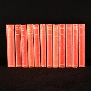
A uniformly bound set of 'Little Guides', a series published by Methuen about British topography. The 'Little Guides' series was published by Methuen & Co. and comprised of pocket-sized guides books to various places of interest. Most of these guidebooks concern English locations of interest and counties, offering a local look at British topography, but the 'Little Guides' also included guidebooks to Wales, Ireland, and Italy.This set is comprised of twelve volumes:Cumberland and Westmorlandby Daniel Scott. The first edition published in 1920. Including twenty-four illustrations from photographs and two folding maps, collated and complete.The English Lakes by F.G. Brabant and illustrated by Edmund H. New. The second edition published in 1920. Including twenty illustrations, and twelve folding maps and plans, collated and complete.Gloucestershireby J. Charles Cox. The third edition published in 1920. Containing thirty-four illustrations, maps, and plans, three of which are folding. Collated and complete.Wiltshire by Frank R. Heath. The fourth edition published in 1919. Containing thirty-two illustrations, two folding maps, and two plans. Collated and complete.Norfolk by William A. Dutt and illustrated by B.C. Boulter. The fifth edition published in 1921. Including thirty illustrations and three folding maps, collated and complete.Somerset by G.W. Wade and J.H. Wade. The eighth edition published in 1929. Including thirty-two illustrations, two folding maps, and two plans, collated and complete.Derbyshire by J. Charles Cox and illustrated by J. Charles Wall. The third edition published in 1921. Including thirty-three illustrations and two folding maps, collated and complete.Herefordshire by G.W. Wade and J.H. Wade. The first edition published in 1917. Containing twenty-eight illustrations and two folding maps, collated and complete.Staffordshire by Charles Masefield. The third edition published in 1923. Containing thirty-two illustrations, two plans, and two folding maps. Collated and complete. Monmouthshire by G.W. Wade and J.H. Wade. The first edition published in 1909. Including thirty-two illustrations, four plans, and four folding maps. Collated and complete.Cornwall by Arthur L. Salmon and illustrated by B.C. Boulter. The seventh edition published in 1930. With twenty-six illustrations and two maps, collated and complete.Northamptonshire by Wakeling Dry. The third edition published in 1920. Including forty illustrations and two folding maps, collated and complete.The volumes in this set contain the odd small pencil notation and ink inscription to the front free-endpapers. Also containing a postcard from H&W Taylor in Bristol and a postcard from Kettlewell From East. Also containing a postcard from the Zoological Gardens in London Uniformly bound in the publisher's original red cloth binding. Externally, generally smart, with some shelf wear. Some slight bumping to the heads and tails of the spines as well as to the extremities, most notable to 'Cornwall'. Spine label is fading slightly to 'Cornwall'. The odd small mark to the boards of some volumes. Slight cockling to the spine of 'Wiltshire'. Internally, front hinges slightly strained to 'The English Lakes', 'Gloucestershire', and 'Wiltshire'. A very small hole has been punctured from the title page to page 166 of 'The English Lakes', though it does not affect readability. Internally, page 103 to 'Staffordshire' is detached but present, otherwise volumes are generally firmly bound. Pages contain the odd pencil notation, and there are a few light handling marks and spots to 'Monmouthshire', 'Wiltshire', and 'Gloucestershire', but otherwise pages are generally clean. Very Good. N° de réf. du vendeur 792J13
Détails bibliographiques
Titre : The Little Guides: Great Britain Counties ...
Éditeur : Methuen and Co. 1909-1930, London
Date d'édition : 1909
Reliure : Cloth
Illustrateur : Various
Etat : Very Good
Type de livre : book
AbeBooks vous offre des millions de livres anciens, neufs, d'occasion et épuisés proposés par des milliers de vendeurs du monde entier. Acheter sur AbeBooks est simple, sűr et 100% sécurisé - effectuez votre recherche, passez commande sur notre site sécurisé et recevez votre ouvrage directement expédié par le vendeur.
Cherchez parmi des millions de livres proposés par des milliers de vendeurs
Livres anciens et de collection
Livres rares, manuscrits, incunables ou livres signés, découvrez notre page consacrée aux livres anciens et de collection.
Editions originales
Tirages limités, éditions spéciales ou numérotées, retrouvez notre sélection d'éditions originales.
Livres d'occasion

Meilleures ventes, idées lecture et lauréats ŕ prix réduits, faites des économies grâce ŕ nos bonnes affaires et ŕ la livraison gratuite.