
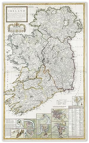
A New Map of Ireland Divided into its Provinces, Counties, and Baronies, wherein are Distinguished the Bishopricks, Borroughs, Barracks, Bogs, Passes, Bridges, &c., with the Principal Roads, and Common Reputed Miles
Moll, Herman
Date d'édition : 1710
Ancien(s) ou d'occasion
No Binding
Vendeur
Antique Print & Map Room, Ultimo, NSW, Australie
Évaluation du vendeur 5 sur 5 étoiles
![]()
Vendeur AbeBooks depuis 1 aoűt 2017
Nous sommes désolés, cet exemplaire spécifique n'est plus disponible. Voici nos correspondances les plus proches pour A New Map of Ireland Divided into its Provinces, Counties, and Baronies, wherein are Distinguished the Bishopricks, Borroughs, Barracks, Bogs, Passes, Bridges, &c., with the Principal Roads, and Common Reputed Miles de Moll, Herman.
A propos de cet article
Description :
Molls spectacular two sheet map of Ireland from, The World Described. This large scale map of Ireland is divided into four provinces and counties. There are six inset town plans across the lower sheet of; Dublin, Cork, Limerick, Waterford, Kinsales and Galway. There is also two views, ' description of St Patrick's Purgatory' and the Giant's Causeway. A table at lower right lists the number of British soldiers garrisoned in each Irish town to keep the population under control and above that a plan of western Europe. From Moll, The World Described, or a New and Correct Sett of Maps Collections: Bibliotheque Nationale de France: Identifier : ark:/12148/btv1b53057272q New York Public Library: 1630444 Image Size: 620mm x 1020mm (24.4" x 40.1"). Condition: Minor wear to centre fold/join as usual, otherwise in good condition. Technique: Hand coloured copper engraving. N° de réf. du vendeur TWDE 027 BI IRE 016
Détails bibliographiques
Titre : A New Map of Ireland Divided into its ...
Date d'édition : 1710
Reliure : No Binding
Etat : Very Good
Meilleurs résultats de recherche sur AbeBooks

A New Map of Ireland Divided into its Provinces, Counties and Baronies, wherein are distinguished the Bishopricks, Borroughs, Barracks, Bogs, Passes, Bridges & c. with the Principal Roads, and the common Reputed Miles.
Edité par
J. & T. Bowles, London, 1714
Ancien ou d'occasion
Vendeur : Alexandre Antique Prints, Maps & Books, Toronto, ON, Canada
Évaluation du vendeur 5 sur 5 étoiles
![]()
Etat : Very Good, two sheets joined. Large and detailed map of Ireland with inset plans of: Dublin, Corke, Limrick, Waterford and Gallway, Kinsale Harbour, the Giant's Causeway.With a dedication to Charles Talbot, Duke of Shrewsbury, with an elaborate cartouche surmounted by his arms. Shrewsbury served as Lord Lieutenant of Ireland between 1710 and 1714, was recalled that year to court and appointed Lord High Treasurer by Queen Anne on her deathbed., Size : 1013x612 (mm), 39.88x24.09 (Inches), Hand Colored. N° de réf. du vendeur M10813
Acheter D'occasion
EUR 2 171,24
Expédition ŕ EUR 5,06
Expédition depuis Canada vers Etats-Unis
Expédition depuis Canada vers Etats-Unis
Quantité disponible : 1 disponible(s)

Image fournie par le vendeur
A New Map of Ireland Divided into its Provinces, Counties, and Baronies, wherein are Distinguished the Bishopricks, Borroughs, Barracks, Bogs, Passes, Bridges, &c., with the Principal Roads, and Common Reputed Miles.
Ancien ou d'occasion
Vendeur : Daniel Crouch Rare Books Ltd, London, Royaume-Uni
Évaluation du vendeur 4 sur 5 étoiles
![]()
Moll's large map of Ireland Engraved map with original outline colour. An elegant and detailed map of Ireland, showing its division into four provinces and thereafter into countries. It is supplemented by five plans of important cities: Dublin, Cork, Limerick, Waterford and Galway. Moll also includes views of notable places in Ireland: Kinsale Harbour, where Charles II was declared king after his father's execution, and where James II fled England after the Glorious Revolution; the Giant's Causeway, basalt columns supposedly built by warring giants; and the Isle of Saint Patrick's Purgatory, a pilgrimage site in County Donegal where Jesus supposedly showed Patrick an entrance to Purgatory. Finally, there is a table at the lower right listing the number of British soldiers garrisoned in each Irish town to keep the population under control, surmounted by a small plan of western Europe. Relations between Britain and Ireland were strained at the time. Ireland had been subdued by the English over the sixteenth and seventeenth century, culminating in the harsh Penal Laws enacted against Catholics during the Interregnum, disenfranchising them and dissolving the Irish parliament. Although the parliament was restored with the restoration of the monarchy, Catholics were still not allowed to vote. As they comprised the vast majority of the population, Irish politics was dominated by Anglo-Irish outsiders, causing deep resentment. The map is dedicated to Charles Talbot, Duke of Shrewsbury, with an elaborate cartouche surmounted by his arms. Shrewsbury served as Lord Lieutenant of Ireland between 1710 and 1714, was recalled that year to court and appointed Lord High Treasurer by Queen Anne on her deathbed. N° de réf. du vendeur 10890
Acheter D'occasion
EUR 2 373,43
Expédition ŕ EUR 23,04
Expédition depuis Royaume-Uni vers Etats-Unis
Expédition depuis Royaume-Uni vers Etats-Unis
Quantité disponible : 1 disponible(s)