


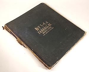
An Illustrated Atlas of Carroll County, Maryland. Compiled, Drawn, and Published from Actual Surveys
Lake, Griffing & Stevenson
Edité par Lake, Griffing & Stevenson, Philadelphia, 1877
Ancien(s) ou d'occasion
Hardcover
Vendeur
The Kelmscott Bookshop, ABAA, Savage, MD, Etats-Unis
Évaluation du vendeur 5 sur 5 étoiles

Honoris Librarius
Membre AbeBooks depuis 1996
Nous sommes désolés, ce livre n'est plus disponible. AbeBooks référence des millions de livres. Veuillez saisir des termes de recherche ci-dessous pour identifier des exemplaires similaires.
A propos de cet article
Description :
Hardcover. A good copy of this uncommon atlas, which is partially disbound with both boards detached, but present. This atlas may be of particular interest to researchers and historians as it lists the landowners as well as many of the local businesses and business owners. Includes a table of distances in the county, population charts for Carroll County, Maryland, and the USA (based on census data), a patron's directory, and several pages of "views" around the County such as the Western Maryland College Campus. Most of the textblock remains in one piece; however, the title page and four rear maps including the map of U.S.A., Maryland, Baltimore, and hemispheres have come loose from the text block and and are laid in. Heavy chipping to the edges of the title page and loose maps. Several of the loose maps have split along the fold. The bulk of the maps though - all pertaining to Carroll County, Maryland - remain bound and intact with only minor chipping to page edges. A few bound in maps have closed tears along the spine fold. Occasional spots of soiling, occasional red pencil markings, and occasional spots from drips of water, but clean overall. All maps are present. The boards are covered in the original dark blue cloth with gilt title to front board and embossed border. Remnants of the original black leather spine are attached to the edges of the boards. Heavy wear to corners and edges of boards. Ex-library with a bookplate to front pastedown. A folio measuring 16.75 x 14 inches. 48 pages plus 4 maps. MD/122723. N° de réf. du vendeur 36973
Détails bibliographiques
Titre : An Illustrated Atlas of Carroll County, ...
Éditeur : Lake, Griffing & Stevenson, Philadelphia
Date d'édition : 1877
Reliure : Hardcover
Etat : Good
Edition : First Edition.
AbeBooks vous offre des millions de livres anciens, neufs, d'occasion et épuisés proposés par des milliers de vendeurs du monde entier. Acheter sur AbeBooks est simple, sûr et 100% sécurisé - effectuez votre recherche, passez commande sur notre site sécurisé et recevez votre ouvrage directement expédié par le vendeur.
Cherchez parmi des millions de livres proposés par des milliers de vendeurs
Livres anciens et de collection
Livres rares, manuscrits, incunables ou livres signés, découvrez notre page consacrée aux livres anciens et de collection.
Editions originales
Tirages limités, éditions spéciales ou numérotées, retrouvez notre sélection d'éditions originales.
Livres d'occasion
Meilleures ventes, idées lecture et lauréats à prix réduits, faites des économies grâce à nos bonnes affaires et à la livraison gratuite.