
Montant total (1 article articles) :
Destination de la commande :

CLASON MAP COMPANY (7 résultats)
Passer aux résultats principaux de la recherche
Filtres de recherche
Type d'article
- Tous les types de produits
- Livres (3)
- Magazines & Périodiques (Aucun autre résultat ne correspond ŕ ces critčres)
- Bandes dessinées (Aucun autre résultat ne correspond ŕ ces critčres)
- Partitions de musique (Aucun autre résultat ne correspond ŕ ces critčres)
- Art, Affiches et Gravures (Aucun autre résultat ne correspond ŕ ces critčres)
- Photographies (Aucun autre résultat ne correspond ŕ ces critčres)
- Cartes (4)
- Manuscrits & Papiers anciens (Aucun autre résultat ne correspond ŕ ces critčres)
Etat En savoir plus
- Neuf (Aucun autre résultat ne correspond ŕ ces critčres)
- Comme neuf, Trčs bon ou Bon (Aucun autre résultat ne correspond ŕ ces critčres)
- Assez bon ou satisfaisant (2)
- Moyen ou mauvais (Aucun autre résultat ne correspond ŕ ces critčres)
- Conformément ŕ la description (5)
Reliure
- Toutes
- Couverture rigide (Aucun autre résultat ne correspond ŕ ces critčres)
- Couverture souple (3)
Particularités
- Ed. originale (Aucun autre résultat ne correspond ŕ ces critčres)
- Signé (Aucun autre résultat ne correspond ŕ ces critčres)
- Jaquette (Aucun autre résultat ne correspond ŕ ces critčres)
- Avec images (7)
- Sans impressions ŕ la demande (7)
Langue (1)
Prix
- Tous les prix
- Moins de EUR 20 (Aucun autre résultat ne correspond ŕ ces critčres)
- EUR 20 ŕ EUR 45 (Aucun autre résultat ne correspond ŕ ces critčres)
- Plus de EUR 45
Livraison gratuite
- Livraison gratuite ŕ destination de Etats-Unis (Aucun autre résultat ne correspond ŕ ces critčres)
Pays
Evaluation du vendeur
-
Clason's Midget Map of Kansas [1918]
Edité par Clason Map Company, 1918
Vendeur : Live Oak Booksellers, Langley, WA, Etats-Unis
Évaluation du vendeur 5 sur 5 étoiles

Carte
EUR 67,32
Expédition ŕ EUR 3,49
Expédition nationale : Etats-UnisQuantité disponible : 1 disponible(s)
Ajouter au panierNo Binding. Etat : Very Good. 13 x 7" map printed in color on one side that folds to about 2 x 3" and fits into a stiff card folder printed in blue. Front panel of card folder has the following information: "Compliments of F.M. Luther & Sons Brokers, Cimarron, Kansas." Map is in near fine condition with one short separation closed with archival repair and no markings. Card stock folder slightly worn and slightly soiled. The Clason Map Company operated in Denver from the early 1900s until the Depression. It published numerous maps in different forms, including a "midget map" series. The distributor of this map, F. M. Luther & Sons, was a real estate brokerage headed by Francis [Frank] Luther, one of the founders of Cimarron, Kansas. I dated this map using a couple of named Kansas highways. The Carrie Nation Highway was established in 1917 and is shown on this map; but this map lacks a "Victory Highway" which was designated ca. 1921. A relatively rare map of Kansas.
-
CLASON'S NEVADA GREEN GUIDE
Edité par The Clason Map Company, n. d. (ca 1920)., Chicago, Denver, 1920
Vendeur : BUCKINGHAM BOOKS, ABAA, ILAB, IOBA, GREENCASTLE, PA, Etats-Unis
Membre d'association : ABAA ILAB IOBA RMABA TXBA
Évaluation du vendeur 5 sur 5 étoiles
EUR 157,08
Expédition ŕ EUR 13,51
Expédition nationale : Etats-UnisQuantité disponible : 1 disponible(s)
Ajouter au panier[NEVADA]. 6 1/4" x 4" green pictorial stiff wrappers printed in black,16 pp., index to Nevada towns, state and city maps, automobile road logs, railroads, hotels, industries, altitudes, population, etc. A fold-out map at the front presents a mileage map of the transcontinental trails of the United States on one side and on the other side a mileage map of the best roads of California and Nevada. Affixed to the rear cover is a color map of Nevada. Both maps are in fine condition. Covers lightly used and rubbed , else a very good copy with light wear to the spine ends and corners.
-
INDEX TO MAP OF UTAH
Edité par The Clason Map Company, 1911., Denver, 1911
Vendeur : BUCKINGHAM BOOKS, ABAA, ILAB, IOBA, GREENCASTLE, PA, Etats-Unis
Membre d'association : ABAA ILAB IOBA RMABA TXBA
Évaluation du vendeur 5 sur 5 étoiles
EUR 175,03
Expédition ŕ EUR 13,51
Expédition nationale : Etats-UnisQuantité disponible : 1 disponible(s)
Ajouter au panier[UTAH]. 6 1/4" x 4" green pictorial stiff wrappers printed in black, 32 pp., index to Utah towns, rivers and creeks, mountains and peaks, valleys and deserts, lakes, plus railroad distances and railroad distances between Utah towns. The color fold-out map of Utah is bight and and colorful. 3" closed split to lower edge of map at fold as well as 1/2" closed split to top edge of map at fold. Folder is clean and tight.
-
[ California Road Atlas ] Easy Fold Maps of California Highways
Edité par The Clason Map Company, 1920
Vendeur : Barry Lawrence Ruderman, La Jolla, CA, Etats-Unis
Membre d'association : ABAA ILAB
Évaluation du vendeur 5 sur 5 étoiles
Carte
EUR 354,54
Expédition ŕ EUR 12,64
Expédition nationale : Etats-UnisQuantité disponible : 1 disponible(s)
Ajouter au panierNo Binding. Etat : VG. Early California road atlas, published by Edward Doheny's California Petroleum Corporation. Includes 4 larger road maps of sections of California and smaller city maps of major cities, including Los Angeles, San Die. Folding map. Covers somewhat toned and worn. Early California road atlas, published by Edward Doheny's California Petroleum Corporation. Includes 4 larger road maps of sections of California and smaller city maps of major cities, including Los Angeles, San Diego, Long Beach, San Francisco, Oakland, San Jose, Santa Barbara, Sacramento, Fresno, and the East Bay. Map.
-
Clason's Double Index Map Chicago wall map
Edité par Clason Map Co, Chicago, 1925
Vendeur : mediumraremaps.com, Franklin, TN, Etats-Unis
Évaluation du vendeur 4 sur 5 étoiles

Carte
EUR 291,71
Expédition ŕ EUR 5,23
Expédition nationale : Etats-UnisQuantité disponible : 1 disponible(s)
Ajouter au panier32 1/2 x 22 3/4 inches. Beautifully composed black and White map of the city of Chicago in very good condition. From Evanston on the north to Riverdale on the south, the map captures the grid system of streeting. From Lake Michigan on the east to Berwyn on the west side, the immensity of order set by the street makes the thought of travel a simple task. This map tells you where your at and all the right angle turns you will make to reach your destination. This is a highly colorable map. Very good but having several separations at the folds. The map is still attached to the cover.
-
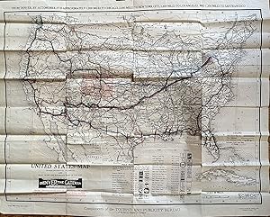
United States Map Transcontinental Highways and Main Trunk Line Railroads West of Chicago
Edité par Clason Map Company: Compliments of the Tourist and Publicity Bureau of the Denver Chamber of Commerce, Denver, 1920
Vendeur : mediumraremaps.com, Franklin, TN, Etats-Unis
Évaluation du vendeur 4 sur 5 étoiles
Carte
EUR 1 346,36
Expédition ŕ EUR 5,23
Expédition nationale : Etats-UnisQuantité disponible : 1 disponible(s)
Ajouter au panierThis is a superb cartographic artifact from the early years of automobile travel. The map is unusual in its large scale. Clason maps are generally a much smaller scale and usually state-centric. This map is rare with WorldCat locating two editions with a total of four copies. This map was used by a well travelled person. The user followed the trail system and marked the routes with blue and red markings. The pre-Federal highway numbering system of Trails dominates the map. The user travelled some trails more than once. Most prominent is the use of the National Old Trails road which was the predecessor to Route 66. Route 66 was introduced in 1926. The National Old Trails road was also known as the Coast-to-Coast highway. The road ran from Baltimore MD to Santa Monica, CA. This map's user travelled the most parts of the road. The Old Spanish Trail was traversed from St Augustine to San Diego. Red markings indicate the portions traveled each day. Multiple other trails were used as listed in the Trails index on the map, including the Oregon Trail.This map is a critical document in the history of transportation. It freezes a time where the consciousness of the traveling public had expanded and opened to the concept of transcontinental travel by car. The map's user chronicled that travel and the journeys are here recorded. The map is undated but WorldCat shows 1920 for the other non-Denver edition. This would be the same or only slightly thereafter. The period precedes heavy Federal involvement with the consciousness of long distance travel by car in its infancy. This is a rarity and an exception period documentation of the road well travelled. Good condition having been used as a travel document. Some tears at the fold intersection and overall mild soiling. The tears have been repaired with archival mending tape. Single sheet Wall Map measuring 32 x 26 inches WorldCat lists two editions with only four total locations found.
-

Kit Carson, Lincoln and Cheyenne Counties, Colorado
Date d'édition : 1907
Vendeur : Art Source International Inc., Boulder, CO, Etats-Unis
Évaluation du vendeur 5 sur 5 étoiles
EUR 444,30
Expédition ŕ EUR 13,94
Expédition nationale : Etats-UnisQuantité disponible : 1 disponible(s)
Ajouter au panierAt the turn of the century, the Clason Map Company was an up and coming publisher that was growing and doing some of their best work. This map is a fine example of their quality. With their trademark simplicity and clarity, the Clason Map Company provided well-detailed work, which remained legible and aesthetically appealing. This map shows detail for the hydrography, railways, and towns. This map of Kit Carson, Lincoln and Cheyenne Counties, Colorado shows Limon with distances to Colorado Springs and Denver. This map measures 32.5 inches by 27 inches.
![Image du vendeur pour Clason's Midget Map of Kansas [1918] mis en vente par Live Oak Booksellers](https://pictures.abebooks.com/inventory/md/md30455518925.jpg)


![Image du vendeur pour [ California Road Atlas ] Easy Fold Maps of California Highways mis en vente par Barry Lawrence Ruderman](https://pictures.abebooks.com/inventory/md/md31306544201.jpg)
