
Montant total (1 article articles) :
Destination de la commande :

SPEEDE, JOHN (35 rťsultats)
Commentaires
Passer aux rťsultats principaux de la recherche
Filtres de recherche
Type d'article
- Tous les types de produits
- Livres (25)
- Magazines & Pťriodiques (Aucun autre rťsultat ne correspond ŗ ces critŤres)
- Bandes dessinťes (Aucun autre rťsultat ne correspond ŗ ces critŤres)
- Partitions de musique (Aucun autre rťsultat ne correspond ŗ ces critŤres)
- Art, Affiches et Gravures (Aucun autre rťsultat ne correspond ŗ ces critŤres)
- Photographies (Aucun autre rťsultat ne correspond ŗ ces critŤres)
- Cartes (10)
- Manuscrits & Papiers anciens (Aucun autre rťsultat ne correspond ŗ ces critŤres)
Etat En savoir plus
- Neuf (3)
- Comme neuf, TrŤs bon ou Bon (2)
- Assez bon ou satisfaisant (20)
- Moyen ou mauvais (Aucun autre rťsultat ne correspond ŗ ces critŤres)
- Conformťment ŗ la description (10)
Particularitťs
- Ed. originale (1)
- Signť (Aucun autre rťsultat ne correspond ŗ ces critŤres)
- Jaquette (Aucun autre rťsultat ne correspond ŗ ces critŤres)
- Avec images (20)
- Sans impressions ŗ la demande (35)
Langue (1)
Livraison gratuite
Pays
Evaluation du vendeur
-

CANTERBURY TOWN PLAN 1610
Editť par Olde Map Company, Penzance, Cornwall, 1991
Vendeur : Stephen Dadd, Ashford, Royaume-Uni
…valuation du vendeur 4 sur 5 ťtoiles

EUR 5,34
Autre deviseEUR 14,89 expťdition depuis Royaume-Uni vers Etats-UnisQuantitť disponible : 1 disponible(s)
Ajouter au panierMap. Etat : Very Good. Antiqued parchment replica of John Speede's map of 1610. In original cardboard slipcase. Size: 8vo - over 7ĺ - 9ĺ" tall. Book.
-
OLD MAP OF YORKSHIRE (GENERAL MAP) 1610
Editť par Olde Map Company, Penzance, Cornwall, 1991
Vendeur : Stephen Dadd, Ashford, Royaume-Uni
…valuation du vendeur 4 sur 5 ťtoiles
EUR 5,34
Autre deviseEUR 14,89 expťdition depuis Royaume-Uni vers Etats-UnisQuantitť disponible : 1 disponible(s)
Ajouter au panierMap. Etat : Very Good. Antiqued parchment replica of John Speede's map of 1610. In original cardboard slipcase. Book.
-
Old Map of Shropshire of 1610, Parchment Replica
Editť par The Olde Map Co, Penzance, 1111
Vendeur : Castle Hill Books, Llandrindod Wells, Royaume-Uni
…valuation du vendeur 4 sur 5 ťtoiles
EUR 2,31
Autre deviseEUR 21,68 expťdition depuis Royaume-Uni vers Etats-UnisQuantitť disponible : 1 disponible(s)
Ajouter au panierHardcover. Etat : New. Antiqued parchment replica of Speeds' 1610 map Wales, in a card slipcase; 8vo 8" - 9" tall.
-
Old Map Wales of 1610, Parchment Replica
Editť par The Olde Map Co, Penzance, 1111
Vendeur : Castle Hill Books, Llandrindod Wells, Royaume-Uni
…valuation du vendeur 4 sur 5 ťtoiles
EUR 2,31
Autre deviseEUR 21,68 expťdition depuis Royaume-Uni vers Etats-UnisQuantitť disponible : 1 disponible(s)
Ajouter au panierHardcover. Etat : New. Antiqued parchment replica of Speeds' 1610 map Wales, in a card slipcase; 8vo 8" - 9" tall.
-
Old Map of Gloucestershire of 1610, Parchment Replica
Editť par The Olde Map Co, Penzance, 1111
Vendeur : Castle Hill Books, Llandrindod Wells, Royaume-Uni
…valuation du vendeur 4 sur 5 ťtoiles
EUR 2,31
Autre deviseEUR 21,68 expťdition depuis Royaume-Uni vers Etats-UnisQuantitť disponible : 1 disponible(s)
Ajouter au panierHardcover. Etat : New. Antiqued parchment replica of Speeds' 1610 map Wales, in a card slipcase; 8vo 8" - 9" tall.
-
Old Map of Durham 1610
Editť par The Old Map Company, Penzance, 1991
Vendeur : WEST WESSEX BOOKS, Taunton, SOMER, Royaume-Uni
…valuation du vendeur 4 sur 5 ťtoiles
EUR 5,92
Autre deviseEUR 19,09 expťdition depuis Royaume-Uni vers Etats-UnisQuantitť disponible : 1 disponible(s)
Ajouter au panierSoft cover. Etat : Very Good. authentic replica on antique parchment, it looks old and acually feels old! As well as showing towns, villages, boundaries as they were during the reign of elizabeth I, there are areal views of many cities, heraldic details,decorations,illustration of battles. Book.
-
Old Map of Lincolnshire1610
Editť par The Old Map Company, Penzance, 1991
Vendeur : WEST WESSEX BOOKS, Taunton, SOMER, Royaume-Uni
…valuation du vendeur 4 sur 5 ťtoiles
EUR 5,92
Autre deviseEUR 19,09 expťdition depuis Royaume-Uni vers Etats-UnisQuantitť disponible : 1 disponible(s)
Ajouter au panierSoft cover. Etat : Very Good. authentic replica on antique parchment, it looks old and acually feels old!,as well as showing towns, villages, boundaries as they were during the reign of elizabeth I, there are areal views of many cities, heraldic details,decorations,illustration of battles. Book.
-
Old Map of Middlesex 1610
Editť par The Old Map Company, Penzance, 1991
Vendeur : WEST WESSEX BOOKS, Taunton, SOMER, Royaume-Uni
…valuation du vendeur 4 sur 5 ťtoiles
EUR 5,92
Autre deviseEUR 19,09 expťdition depuis Royaume-Uni vers Etats-UnisQuantitť disponible : 1 disponible(s)
Ajouter au panierSoft cover. Etat : Very Good. authentic replica on antique parchment, il look old and acually feels old!,as well as showing towns, villages, boundaries as they were during the reign of elizabeth I, there are areal views of many cities, heraldic details,decorations,illustration of battles. Book.
-
Olde Map of Cornwall: An Antiqued Parchment Replica (The Olde Map Company)
Editť par The Olde Map Company
Vendeur : Wonder Book, Frederick, MD, Etats-Unis
Membre d'association : ABAA ILAB
…valuation du vendeur 5 sur 5 ťtoiles

EUR 21,67
Autre deviseGratuit expťdition vers Etats-UnisQuantitť disponible : 1 disponible(s)
Ajouter au panierEtat : As New. Like New condition. Slipcase Very Good. (Cornwall, Great Britain, maps ) A near perfect copy that may have very minor cosmetic defects.
-
Old Map of Derbyshire 1610 (No. 334 ) - Authentic Replica on Antiqued Parchment
Editť par The Olde Map Company, UK, 1991
Vendeur : Jaycey Books, Ruislip, Royaume-Uni
…valuation du vendeur 5 sur 5 ťtoiles
EUR 11,85
Autre deviseEUR 18,40 expťdition depuis Royaume-Uni vers Etats-UnisQuantitť disponible : 1 disponible(s)
Ajouter au panierSoft cover. Etat : Good. Folded replica map in original envelope. Publisher and date taken from Amazon listing of slightly later map in the same series. Good condition map, with rectangular area, and 2 smaller areas, sunned due to window in envelope. Small tear and several small marks to envelope. - - - General information: please email for any more information or condition photos. If you request condition photos, these will be added to the AbeBooks listing within 2 business days. There may be other minor faults not included here, but this description should include all important points and convey accurately the overall condition of the book(s) or other item. We are happy to give a more detailed description (by volume where applicable) on request. Please note that if there is a photo next to the listing which is titled 'Stock Photo', this is a generic photo provided by abebooks and not a photo of the actual book listed. The design of the covers and binding may be the same or may differ substantially. Posted next day (Mon-Fri) from the UK. We normally post by Royal Mail 1st class within the UK, but may use a slower service for books over 1kg or multiple orders or a tracked service for higher value orders. We normally post by tracked mail for overseas deliveries, and may request additional postage (at cost) for heavier books (buyers always have the option to cancel the order if we do so).
-
Old Map of Devon 1610
Editť par The Old Map Company, Penzance, 1991
Vendeur : WEST WESSEX BOOKS, Taunton, SOMER, Royaume-Uni
…valuation du vendeur 4 sur 5 ťtoiles
EUR 11,85
Autre deviseEUR 19,09 expťdition depuis Royaume-Uni vers Etats-UnisQuantitť disponible : 1 disponible(s)
Ajouter au panierSoft cover. Etat : Very Good. No Jacket. Authentic replica on antique parchment, it looks old and acually feels old!,as well as showing towns, villages, boundaries as they were during the reign of elizabeth I, there are areal views of many cities, heraldic details,decorations,illustration of battles. Book.
-

Old Map of Nottinghamshire 1610
Editť par The Olde Map Co, Penzance, 1991
Vendeur : Lazy Letters Books, Market Rasen, Royaume-Uni
…valuation du vendeur 5 sur 5 ťtoiles
EUR 4,74
Autre deviseEUR 20,47 expťdition depuis Royaume-Uni vers Etats-UnisQuantitť disponible : 1 disponible(s)
Ajouter au panierMap. Etat : Very Good. Antiqued parchment replica folded in card pocket.
-

Map of the countie of Nottingham
Editť par Unknown, 1985
Vendeur : Aucott & Thomas, Ibstock, Royaume-Uni
…valuation du vendeur 5 sur 5 ťtoiles
Carte
EUR 11,37
Autre deviseEUR 17,25 expťdition depuis Royaume-Uni vers Etats-UnisQuantitť disponible : 1 disponible(s)
Ajouter au panierMap. Etat : Very Good. Reprint. Coloured reprint of John Speede's 1610 map. Map is 58.3 x 45.5cm, border is 3.5cm. No marks, chips or inscriptions. Undated but assume mid 1980s. Printed on very good quality cartridge paper, and will be sent in a cardboard tube to avoid postal damage.
-

Map of Suffolk(e)
Editť par Unknown, 1985
Vendeur : Aucott & Thomas, Ibstock, Royaume-Uni
…valuation du vendeur 5 sur 5 ťtoiles
Carte
EUR 11,37
Autre deviseEUR 17,25 expťdition depuis Royaume-Uni vers Etats-UnisQuantitť disponible : 1 disponible(s)
Ajouter au panierMap. Etat : Very Good. Reprint. Coloured reprint of John Speede's 1610 map. Map is 58.3 x 45.5cm, border is 3.5cm. Edge creased at bottom left corner, 2 small closed tears at bottom edge, no inscriptions. Undated but assume mid 1980s.
-

Map of Oxfordshire
Editť par Unknown, 1985
Vendeur : Aucott & Thomas, Ibstock, Royaume-Uni
…valuation du vendeur 5 sur 5 ťtoiles
Carte
EUR 11,37
Autre deviseEUR 17,25 expťdition depuis Royaume-Uni vers Etats-UnisQuantitť disponible : 1 disponible(s)
Ajouter au panierMap. Etat : Very Good. Reprint. Coloured reprint of John Speede's 1610 map. Map is 58.3 x 45.5cm, border is 3.5cm. Edge creased at bottom corners, 2 small closed tears on left edge & on bottom edge, no inscriptions. Undated but assume mid 1980s.
-

Map of Herefordshire
Editť par Unknown, 1985
Vendeur : Aucott & Thomas, Ibstock, Royaume-Uni
…valuation du vendeur 5 sur 5 ťtoiles
Carte
EUR 11,37
Autre deviseEUR 17,25 expťdition depuis Royaume-Uni vers Etats-UnisQuantitť disponible : 1 disponible(s)
Ajouter au panierMap. Etat : Very Good. Reprint. Coloured reprint of John Speede's 1610 map. Map is 58.3 x 45.5cm, border is 3.5cm. Lightly creased with short closed tear at top edge, no inscriptions. Undated but assume mid 1980s.
-

Map of Wilshire (Wiltshire)
Editť par Unknown, 1985
Vendeur : Aucott & Thomas, Ibstock, Royaume-Uni
…valuation du vendeur 5 sur 5 ťtoiles
Carte
EUR 11,37
Autre deviseEUR 17,25 expťdition depuis Royaume-Uni vers Etats-UnisQuantitť disponible : 1 disponible(s)
Ajouter au panierMap. Etat : Very Good. Reprint. Coloured reprint of John Speede's 1610 map. Map is 58.3 x 45.5cm, border is 3.5cm. No creases, chips or inscriptions. Undated but assume mid 1980s.
-

Map of Somerset-shire
Editť par Unknown, 1985
Vendeur : Aucott & Thomas, Ibstock, Royaume-Uni
…valuation du vendeur 5 sur 5 ťtoiles
Carte
EUR 11,37
Autre deviseEUR 17,25 expťdition depuis Royaume-Uni vers Etats-UnisQuantitť disponible : 1 disponible(s)
Ajouter au panierMap. Etat : Very Good. Reprint. Coloured reprint of John Speede's 1610 map. Map is 58.3 x 45.5cm, border is 3.5cm. Edges lightly creased and 2 small closed tears, one at each edge (will not show once framed), no inscriptions. Undated but assume mid 1980s. Printed on very good quality cartridge paper, and will be sent in a cardboard tube to avoid postal damage.
-

Map of Derbyshire (Darbieshire)
Editť par Unknown, 1985
Vendeur : Aucott & Thomas, Ibstock, Royaume-Uni
…valuation du vendeur 5 sur 5 ťtoiles
Carte
EUR 11,37
Autre deviseEUR 17,25 expťdition depuis Royaume-Uni vers Etats-UnisQuantitť disponible : 1 disponible(s)
Ajouter au panierMap. Etat : Very Good. Reprint. Coloured reprint of John Speede's 1610 map. Map is 58.3 x 45.5cm, border is 3.5cm. No marks, chips or inscriptions. Undated but assume mid 1980s. Printed on very good quality cartridge paper, and will be sent in a cardboard tube to avoid postal damage.
-
Old Map of Warwickshire 1610
Editť par Porter Prints, York
Vendeur : Anvil Books, Prestatyn, FLINT, Royaume-Uni
…valuation du vendeur 5 sur 5 ťtoiles
EUR 5,92
Autre deviseEUR 27,60 expťdition depuis Royaume-Uni vers Etats-UnisQuantitť disponible : 1 disponible(s)
Ajouter au panierMap. Etat : Fine. No Jacket. Rep. 20 x 15 inches, folded as issued in sl worn envelope. Authentic replica on antiqued parchment.
-
OLD MAP OF LANCASHIRE 1610 - Antiqued Parchment Replica.
Editť par The Old Map Company, 1991
Vendeur : Virginia Bank Books., ACLE, Norfolk, NOR, Royaume-Uni
…valuation du vendeur 5 sur 5 ťtoiles
EUR 3,50
Autre deviseEUR 33,81 expťdition depuis Royaume-Uni vers Etats-UnisQuantitť disponible : 1 disponible(s)
Ajouter au panier(10300) Antiqued Parchment Map of Speede's 1610 map of Lancashire in red card slipcase. Ex shop stock. As new.
-
Old Map of Shropshire 1610.
Editť par Cornwall: The Olde Map Co, 1991., 1991
Vendeur : Salopian Books, Shrewsbury, SAL, Royaume-Uni
Membre d'association : IOBA
…valuation du vendeur 5 sur 5 ťtoiles
Carte
EUR 2,37
Autre deviseEUR 36,80 expťdition depuis Royaume-Uni vers Etats-UnisQuantitť disponible : 1 disponible(s)
Ajouter au panierNo Binding. Etat : Good. Replica 'antiqued parchment' fold-out map in good condition in card sleeve. Some general wear and marks to sleeve. 8vo.
-

Olde Map of Durham 1610
Editť par The Olde Map Company, 1991
Vendeur : Peter Pan books, Durham, Royaume-Uni
…valuation du vendeur 5 sur 5 ťtoiles
EUR 5,92
Autre deviseEUR 34,50 expťdition depuis Royaume-Uni vers Etats-UnisQuantitť disponible : 1 disponible(s)
Ajouter au panierNo Binding. Etat : Very Good. Good condition 'antiqued parchment replica' [abeb].
-

The Kingdome of Irland - Divided into several Provinces, and the againe devided into Counties
Vendeur : Kennys Bookshop and Art Galleries Ltd., Galway, GY, Irlande
…valuation du vendeur 5 sur 5 ťtoiles
EUR 39,95
Autre deviseEUR 10,50 expťdition depuis Irlande vers Etats-UnisQuantitť disponible : 5 disponible(s)
Ajouter au panierEtat : Very Good. . Hardback. "Extremely rare print. Few available. Reproduction of the famous John Speede map of Ireland from 1610. This was the earliest proper map of Ireland, and original copies are now scarce and very highly valued." Keywords: Posters - Ireland - Maps & Prints - Antique Maps. Not a first edition copy. . . .
-

The Kingdome of Irland - Divided into several Provinces, and the againe devided into Counties
Vendeur : Kennys Bookstore, Olney, MD, Etats-Unis
…valuation du vendeur 5 sur 5 ťtoiles
EUR 41,18
Autre deviseEUR 8,84 expťdition vers Etats-UnisQuantitť disponible : 5 disponible(s)
Ajouter au panierEtat : Very Good. . Hardback. "Extremely rare print. Few available. Reproduction of the famous John Speede map of Ireland from 1610. This was the earliest proper map of Ireland, and original copies are now scarce and very highly valued." Keywords: Posters - Ireland - Maps & Prints - Antique Maps. Not a first edition copy. . . . Books ship from the US and Ireland.
-
?Miniature? Herefordshire. Original Antique Engraved Hand Coloured Miniature Map of Herefordshire.
Editť par London, Sudbury & Humble, 1627, 1627
Vendeur : PROCTOR / THE ANTIQUE MAP & BOOKSHOP, DORCHESTER, Royaume-Uni
Membre d'association : PBFA
…valuation du vendeur 5 sur 5 ťtoiles
EUR 85,29
Autre deviseEUR 23 expťdition depuis Royaume-Uni vers Etats-UnisQuantitť disponible : 1 disponible(s)
Ajouter au panierSo-called ?Miniature Speed.? Engraved surface approx 12 x 8 cm. Overall 15 x 9 cm. (approx 6 x 4 inches.) In very good condition. Nice bright colouring. Some minor darkening around edges. Bottom corner/edge of map is slightly clipped by page edge. Else an excellent clean and bright example. Original double-sided engraved map with later hand colouring, and part description of county on rear.
-
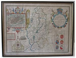
John Speede County Map SPEEDE'S NOTTINGHAM The Countie of Nottingham described The Shire Townes Situation and the Earls thereof observed
Editť par London Performed by John Speede and to be sold by Thomas Bassett in Fleet Street & Richard Chiswell in St Pauls Church Yard, 1610
Vendeur : John L. Capes (Books) Established 1969, STAITHES, Royaume-Uni
Membre d'association : PBFA
…valuation du vendeur 5 sur 5 ťtoiles
EUR 325,76
Autre deviseEUR 31,05 expťdition depuis Royaume-Uni vers Etats-UnisQuantitť disponible : 1 disponible(s)
Ajouter au panierThe Nottinghamshire county map, [ with inset plan of the town ] from Speed's "Theatre of the Empire" the first Atlas of the British Isles.The 1676 Bassett & Chiswell issue with nice early colouring and good margins double glazed with English text to the back.
-
Somerset shire Described
Editť par London, 1610
Vendeur : Graver & Pen Rare Books, Midland, MI, Etats-Unis
…valuation du vendeur 5 sur 5 ťtoiles
EUR 390,42
Autre deviseEUR 3,36 expťdition vers Etats-UnisQuantitť disponible : 1 disponible(s)
Ajouter au panierNo Binding. Etat : Good. No Jacket. Attractive hand coloring. Good. Creasing to middle, Japanese paper repair to various tears, yellowing to paper. Includes inset view of Bath (Bathe) and coats-of-arms in lower corners and sea colored blue with ships. From John SpeedŅs Theatre of the Empire of Great Britaine. Anno 1610 in lower corner, but a scarce reprint circa 1690 - 1695 by "Christopher Browne, at the Globe near the West End of St. Paul's Church London".
-
RUTLANDSHIRE With OUKHAM and STANFORD. Original Antique Engraved Hand Coloured Map of RUTLANDSHIRE. With, Arms of Nobles and County Crest. Plan of County Towns OUKHAM and STANFORD. Illustrations of Scribes to bottom corners.
Editť par London, Sudbury & Humbell, 1620, 1620
Vendeur : PROCTOR / THE ANTIQUE MAP & BOOKSHOP, DORCHESTER, Royaume-Uni
Membre d'association : PBFA
…valuation du vendeur 5 sur 5 ťtoiles
EUR 390,91
Autre deviseEUR 23 expťdition depuis Royaume-Uni vers Etats-UnisQuantitť disponible : 1 disponible(s)
Ajouter au panierPrinted area is approximately 50.6cms by 38.1cms. In very good condition. A minor crease on right hand margin, vertical center hold crease. Nice colouring. Some minor tanning, else A beautiful clean example. Ready to be Framed Original engraved map with hand colouring. A highly decorative 17th century map of Rutland, based on the survey by John Harrington, which was published in John Speed's Theatre of the Empire of Great Britaine (London: Sudbury & Humble, 1620s [No text]). The inset town plans of Stamford and Oakham, probably surveyed by Speed himself, are the earliest known of these places. This particular example comes from an unusual and undated atlas (probably 1620s).
-
Wight Island. First Edition of Speed's map of the Isle of Wight. Original Antique Engraved Hand Coloured Map of Wight Island. The Isle of Wight, with inset town plans of Southampton and Newport.
Editť par London, Sudbury & Humbell, 1611-12, 1611
Vendeur : PROCTOR / THE ANTIQUE MAP & BOOKSHOP, DORCHESTER, Royaume-Uni
Membre d'association : PBFA
…valuation du vendeur 5 sur 5 ťtoiles
EUR 503,45
Autre deviseEUR 23 expťdition depuis Royaume-Uni vers Etats-UnisQuantitť disponible : 1 disponible(s)
Ajouter au panierPrinted area is approximately 52cms by 39cms. Held in Ivory mount, with one gilt line border. In good condition. Two old tape strips lower left corner, slightly creased & small nick lower right corner. A few very faint small brown spots. Ready to be Framed Original engraved map with Uncoloured. This map was engraved by Jodocus Hondius and published in the first edition of John Speed's important atlas, 'The Theatre of the Empire of Great Britain'.


