
Montant total (1 article articles) :
Destination de la commande :

bellin jacques nicolas paris (89 résultats)
Commentaires
Passer aux résultats principaux de la recherche
Filtres de recherche
Type d'article
- Tous les types de produits
- Livres (77)
- Magazines & Périodiques (Aucun autre résultat ne correspond ŕ ces critčres)
- Bandes dessinées (Aucun autre résultat ne correspond ŕ ces critčres)
- Partitions de musique (Aucun autre résultat ne correspond ŕ ces critčres)
- Art, Affiches et Gravures (2)
- Photographies (Aucun autre résultat ne correspond ŕ ces critčres)
- Cartes (10)
- Manuscrits & Papiers anciens (Aucun autre résultat ne correspond ŕ ces critčres)
Etat En savoir plus
- Neuf (Aucun autre résultat ne correspond ŕ ces critčres)
- Comme neuf, Trčs bon ou Bon (Aucun autre résultat ne correspond ŕ ces critčres)
- Assez bon ou satisfaisant (Aucun autre résultat ne correspond ŕ ces critčres)
- Moyen ou mauvais (Aucun autre résultat ne correspond ŕ ces critčres)
- Conformément ŕ la description (89)
Reliure
- Toutes
- Couverture rigide (Aucun autre résultat ne correspond ŕ ces critčres)
- Couverture souple (Aucun autre résultat ne correspond ŕ ces critčres)
Particularités
- Ed. originale (Aucun autre résultat ne correspond ŕ ces critčres)
- Signé (Aucun autre résultat ne correspond ŕ ces critčres)
- Jaquette (Aucun autre résultat ne correspond ŕ ces critčres)
- Avec images (89)
- Sans impressions ŕ la demande (89)
Langue (1)
Livraison gratuite
- Livraison gratuite ŕ destination de Etats-Unis (Aucun autre résultat ne correspond ŕ ces critčres)
Pays
Evaluation du vendeur
-

Carte du Détroit de Waeigats, ou de Nassau.
Edité par Artist: Bellin Jacques Nicolas ( - 1772 ) Paris; issued in: Paris; - Jacques-Nicolas Bellin (1703 Paris -1772 Versailles) was a French cartographer engineer-geographer marine hydrographer As a contributor to the Encyclopédie he wrote more than a thousand articles on maritime topics As a cartographer Bellin distinguished himself primarily in the field of sea cartography From 1721 he worked for the Dépot des Cartes et Plans de la Marine from 1741 until his death as an engineer-hydrograph of the Navy In 1753 his atlas Neptune français which covered all the coasts of France was published and in 1756 the hydrography françoise covering all seas of the earth In 1764 the five-volume Petit Atlas maritime was published which Bellin prepared on the or, 1703
Vendeur : Antique Sommer& Sapunaru KG, München, Allemagne
Membre d'association : ILAB VDA
Évaluation du vendeur 5 sur 5 étoiles

EUR 80
Autre deviseEUR 45 expédition depuis Allemagne vers Etats-UnisQuantité disponible : 1 disponible(s)
Ajouter au panierTechnic: Copper print, colorit: coloredcondition: Perfect condition, size (in cm): 19,5 x 30,5 cm; - Map shows the south part of Vaygach Island in the Arctic Sea, the Yugorsky Strait and partly Russia. Sailing in the Arctic ocean, In June 1594, Linschoten sailed from Texel in the expedition headed by Dutch cartographer Willem Barentsz. Three ships intended to enter the Kara Sea, hoping to find the Northeast Passage above Siberia. Nearing Williams Island the crew for the first time encountered a polar bear. After enticing it on board the bear then rampaged and had to be killed. Barentsz approached the west coast of Nova Zembla and heading north, before being forced to turn back in due to danger from large icebergs. The following year they sailed again in a new expedition of six ships, loaded with merchant wares that they hoped to trade with China. The party came across Samoyed ;wild men; but eventually had to turn back when discovering the Kara Sea to be frozen. Linschoten was one of the two crew members to publish journals of the Barentsz expedition. From : Maps for Prevost's L'Histoire Générale des Voyages - 1747-61.
-

Plan de la Ville de Paita Dans le Royaume de Santa fe
Edité par Artist: Bellin Jacques Nicolas ( - 1772 ) Paris; issued in: Paris; - Jacques-Nicolas Bellin (1703 Paris -1772 Versailles) was a French cartographer engineer-geographer marine hydrographer As a contributor to the Encyclopédie he wrote more than a thousand articles on maritime topics As a cartographer Bellin distinguished himself primarily in the field of sea cartography From 1721 he worked for the Dépot des Cartes et Plans de la Marine from 1741 until his death as an engineer-hydrograph of the Navy In 1753 his atlas Neptune français which covered all the coasts of France was published and in 1756 the hydrography françoise covering all seas of the earth In 1764 the five-volume Petit Atlas maritime was published which Bellin prepared on the or, 1703
Vendeur : Antique Sommer& Sapunaru KG, München, Allemagne
Membre d'association : ILAB VDA
Évaluation du vendeur 5 sur 5 étoiles
EUR 80
Autre deviseEUR 45 expédition depuis Allemagne vers Etats-UnisQuantité disponible : 1 disponible(s)
Ajouter au panierTechnic: Copper print, colorit: coloredcondition: Perfect condition, size (in cm): 20,5 x 37 cm cm; - Plan of the peruvian town of Paita on the coast of Stanta Fe.
-

Karte von der westlichen Tartarey
Edité par Artist: Bellin Jacques Nicolas ( - 1772 ) Paris; issued in: Paris; - Jacques-Nicolas Bellin (1703 Paris -1772 Versailles) was a French cartographer engineer-geographer marine hydrographer As a contributor to the Encyclopédie he wrote more than a thousand articles on maritime topics As a cartographer Bellin distinguished himself primarily in the field of sea cartography From 1721 he worked for the Dépot des Cartes et Plans de la Marine from 1741 until his death as an engineer-hydrograph of the Navy In 1753 his atlas Neptune français which covered all the coasts of France was published and in 1756 the hydrography françoise covering all seas of the earth In 1764 the five-volume Petit Atlas maritime was published which Bellin prepared on the or, 1703
Vendeur : Antique Sommer& Sapunaru KG, München, Allemagne
Membre d'association : ILAB VDA
Évaluation du vendeur 5 sur 5 étoiles
EUR 100
Autre deviseEUR 45 expédition depuis Allemagne vers Etats-UnisQuantité disponible : 1 disponible(s)
Ajouter au panierTechnic: Copper print, colorit: coloredcondition: Very good, size (in cm): 22 x 30,5 cm cm; - Map shows Mongolia and the eastern Mongolia in China. Its area is roughly equivalent with the historical territory of Outer Mongolia, and that term is sometimes used to refer to the current state. It is sandwiched between Russia to the north and China to the south, where it neighbours the Inner Mongolia Autonomous Region. The area of what is now Mongolia has been ruled by various nomadic empires, including the Xiongnu, the Xianbei, the Rouran, the Turkic Khaganate, and others.
-

Karte von der kleinen Bukharey und benachbarten Laendern
Edité par Artist: Bellin Jacques Nicolas ( - 1772 ) Paris; issued in: Paris; - Jacques-Nicolas Bellin (1703 Paris -1772 Versailles) was a French cartographer engineer-geographer marine hydrographer As a contributor to the Encyclopédie he wrote more than a thousand articles on maritime topics As a cartographer Bellin distinguished himself primarily in the field of sea cartography From 1721 he worked for the Dépot des Cartes et Plans de la Marine from 1741 until his death as an engineer-hydrograph of the Navy In 1753 his atlas Neptune français which covered all the coasts of France was published and in 1756 the hydrography françoise covering all seas of the earth In 1764 the five-volume Petit Atlas maritime was published which Bellin prepared on the or, 1703
Vendeur : Antique Sommer& Sapunaru KG, München, Allemagne
Membre d'association : ILAB VDA
Évaluation du vendeur 5 sur 5 étoiles
EUR 100
Autre deviseEUR 45 expédition depuis Allemagne vers Etats-UnisQuantité disponible : 1 disponible(s)
Ajouter au panierTechnic: Copper print, colorit: coloredcondition: Very good, size (in cm): 21,5,x 30,5 cm; - Map shows the city of Turfan in Hsinkiang-Uigur ,north west China. Xinjiang consists of two main geographically, historically, and ethnically distinct regions with different historical names. The Qing dynasty was well aware of the differences between the former Buddhist Mongol area to the north of the Tian Shan and the Turkic Muslim area south of the Tian Shan, and ruled them in separate administrative units at first. However, Qing people began to think of both areas as part of one distinct region called Xinjiang. The Xinjiang conflict is a conflict in China's far-west province of Xinjiang centred around the Uyghurs, a Turkic minority ethnic group who make up the largest group in the region.
-

Isola di Madagascar
Edité par Artist: Bellin Jacques Nicolas ( - 1772 ) Paris; issued in: Paris; - Jacques-Nicolas Bellin (1703 Paris -1772 Versailles) was a French cartographer engineer-geographer marine hydrographer As a contributor to the Encyclopédie he wrote more than a thousand articles on maritime topics As a cartographer Bellin distinguished himself primarily in the field of sea cartography From 1721 he worked for the Dépot des Cartes et Plans de la Marine from 1741 until his death as an engineer-hydrograph of the Navy In 1753 his atlas Neptune français which covered all the coasts of France was published and in 1756 the hydrography françoise covering all seas of the earth In 1764 the five-volume Petit Atlas maritime was published which Bellin prepared on the or, 1703
Vendeur : Antique Sommer& Sapunaru KG, München, Allemagne
Membre d'association : ILAB VDA
Évaluation du vendeur 5 sur 5 étoiles
EUR 100
Autre deviseEUR 45 expédition depuis Allemagne vers Etats-UnisQuantité disponible : 1 disponible(s)
Ajouter au panierTechnic: Copper print, colorit: coloredcondition: Right margin replaced, size (in cm): 17 x 23 cm; - Map shows the island Madagascar.
-

Carte exacte de la Cote du Cap Verde
Edité par Artist: Bellin Jacques Nicolas ( - 1772 ) Paris; issued in: Paris; - Jacques-Nicolas Bellin (1703 Paris -1772 Versailles) was a French cartographer engineer-geographer marine hydrographer As a contributor to the Encyclopédie he wrote more than a thousand articles on maritime topics As a cartographer Bellin distinguished himself primarily in the field of sea cartography From 1721 he worked for the Dépot des Cartes et Plans de la Marine from 1741 until his death as an engineer-hydrograph of the Navy In 1753 his atlas Neptune français which covered all the coasts of France was published and in 1756 the hydrography françoise covering all seas of the earth In 1764 the five-volume Petit Atlas maritime was published which Bellin prepared on the or, 1703
Vendeur : Antique Sommer& Sapunaru KG, München, Allemagne
Membre d'association : ILAB VDA
Évaluation du vendeur 5 sur 5 étoiles
EUR 100
Autre deviseEUR 45 expédition depuis Allemagne vers Etats-UnisQuantité disponible : 1 disponible(s)
Ajouter au panierTechnic: Copper print, colorit: original coloredcondition: Perfect condition, size (in cm): 22 x 14 cm cm; - Map shows the coast of Senegal with Cap Verde, on seperate map a view of the Island Goree and Cap Emanuel.
-
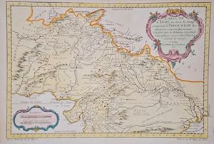
Carte de l'Inde en decŕ du Gange comprenant l'Indoustan & c.
Edité par Artist: Bellin Jacques Nicolas ( - 1772 ) Paris; issued in: Paris; - Jacques-Nicolas Bellin (1703 Paris -1772 Versailles) was a French cartographer engineer-geographer marine hydrographer As a contributor to the Encyclopédie he wrote more than a thousand articles on maritime topics As a cartographer Bellin distinguished himself primarily in the field of sea cartography From 1721 he worked for the Dépot des Cartes et Plans de la Marine from 1741 until his death as an engineer-hydrograph of the Navy In 1753 his atlas Neptune français which covered all the coasts of France was published and in 1756 the hydrography françoise covering all seas of the earth In 1764 the five-volume Petit Atlas maritime was published which Bellin prepared on the or, 1703
Vendeur : Antique Sommer& Sapunaru KG, München, Allemagne
Membre d'association : ILAB VDA
Évaluation du vendeur 5 sur 5 étoiles
EUR 120
Autre deviseEUR 45 expédition depuis Allemagne vers Etats-UnisQuantité disponible : 1 disponible(s)
Ajouter au panierTechnic: Copper print, colorit: coloredcondition: Perfect condition, size (in cm): 22,5 x 33,5 cm; - Map shows partly India with the river Ganges and the cities Benares (Varanasi oder Kashi), Dehli, Agra, Surat, Khambhat, Diu,and tow decorative cartouches. From : Maps for Prevost's L'Histoire Générale des Voyages - 1747-61.
-

Carte de la Riviere de la Plata,.
Edité par Artist: Bellin Jacques Nicolas ( - 1772 ) Paris; issued in: Paris; - Jacques-Nicolas Bellin (1703 Paris -1772 Versailles) was a French cartographer engineer-geographer marine hydrographer As a contributor to the Encyclopédie he wrote more than a thousand articles on maritime topics As a cartographer Bellin distinguished himself primarily in the field of sea cartography From 1721 he worked for the Dépot des Cartes et Plans de la Marine from 1741 until his death as an engineer-hydrograph of the Navy In 1753 his atlas Neptune français which covered all the coasts of France was published and in 1756 the hydrography françoise covering all seas of the earth In 1764 the five-volume Petit Atlas maritime was published which Bellin prepared on the or, 1703
Vendeur : Antique Sommer& Sapunaru KG, München, Allemagne
Membre d'association : ILAB VDA
Évaluation du vendeur 5 sur 5 étoiles
EUR 120
Autre deviseEUR 45 expédition depuis Allemagne vers Etats-UnisQuantité disponible : 1 disponible(s)
Ajouter au panierTechnic: Copper print, colorit: original coloredcondition: Perfect condition, size (in cm): 18,5 x 28,5 cm cm; - Map shows the Rio Plata in Uruguay with the cities of Colonia del Sacramento, Montevideo to the bay of Maldonado and Argentinia with the cities Buenos Aires and Punta Piedras.
-

Carte des Entrées de la Riviere de Scherbro ou Cerbera
Edité par Artist: Bellin Jacques Nicolas ( - 1772 ) Paris; issued in: Paris; - Jacques-Nicolas Bellin (1703 Paris -1772 Versailles) was a French cartographer engineer-geographer marine hydrographer As a contributor to the Encyclopédie he wrote more than a thousand articles on maritime topics As a cartographer Bellin distinguished himself primarily in the field of sea cartography From 1721 he worked for the Dépot des Cartes et Plans de la Marine from 1741 until his death as an engineer-hydrograph of the Navy In 1753 his atlas Neptune français which covered all the coasts of France was published and in 1756 the hydrography françoise covering all seas of the earth In 1764 the five-volume Petit Atlas maritime was published which Bellin prepared on the or, 1703
Vendeur : Antique Sommer& Sapunaru KG, München, Allemagne
Membre d'association : ILAB VDA
Évaluation du vendeur 5 sur 5 étoiles
EUR 120
Autre deviseEUR 45 expédition depuis Allemagne vers Etats-UnisQuantité disponible : 1 disponible(s)
Ajouter au panierTechnic: Copper print, colorit: original coloredcondition: Perfect condition, size (in cm): 18 x 25 cm cm; - Map partly showing Sierra Leone with the offshore island "Isle de Scherbro ou de Cerbera" in Africa and a title cartouche.
-

Carte Particuliere des Isles Moluques
Edité par Artist: Bellin Jacques Nicolas ( - 1772 ) Paris; issued in: Paris; - Jacques-Nicolas Bellin (1703 Paris -1772 Versailles) was a French cartographer engineer-geographer marine hydrographer As a contributor to the Encyclopédie he wrote more than a thousand articles on maritime topics As a cartographer Bellin distinguished himself primarily in the field of sea cartography From 1721 he worked for the Dépot des Cartes et Plans de la Marine from 1741 until his death as an engineer-hydrograph of the Navy In 1753 his atlas Neptune français which covered all the coasts of France was published and in 1756 the hydrography françoise covering all seas of the earth In 1764 the five-volume Petit Atlas maritime was published which Bellin prepared on the or, 1703
Vendeur : Antique Sommer& Sapunaru KG, München, Allemagne
Membre d'association : ILAB VDA
Évaluation du vendeur 5 sur 5 étoiles
EUR 140
Autre deviseEUR 45 expédition depuis Allemagne vers Etats-UnisQuantité disponible : 1 disponible(s)
Ajouter au panierTechnic: Copper print, colorit: coloredcondition: Perfect condition, size (in cm): 20,5 x 15,5 cm; - Map depicts the Mollucces in South East Asia.
-

Suite de la Coste de Guinée
Edité par Artist: Bellin Jacques Nicolas ( - 1772 ) Paris; issued in: Paris; - Jacques-Nicolas Bellin (1703 Paris -1772 Versailles) was a French cartographer engineer-geographer marine hydrographer As a contributor to the Encyclopédie he wrote more than a thousand articles on maritime topics As a cartographer Bellin distinguished himself primarily in the field of sea cartography From 1721 he worked for the Dépot des Cartes et Plans de la Marine from 1741 until his death as an engineer-hydrograph of the Navy In 1753 his atlas Neptune français which covered all the coasts of France was published and in 1756 the hydrography françoise covering all seas of the earth In 1764 the five-volume Petit Atlas maritime was published which Bellin prepared on the or, 1703
Vendeur : Antique Sommer& Sapunaru KG, München, Allemagne
Membre d'association : ILAB VDA
Évaluation du vendeur 5 sur 5 étoiles
EUR 140
Autre deviseEUR 45 expédition depuis Allemagne vers Etats-UnisQuantité disponible : 1 disponible(s)
Ajouter au panierTechnic: Copper print, colorit: original coloredcondition: Perfect condition, size (in cm): 21 x 29 cm cm; - Map showing part of the coast of Ghana with the town of Axim and a title cartouche.
-

Carte du Spits-Berg
Edité par Artist: Bellin Jacques Nicolas ( - 1772 ) Paris; issued in: Paris; - Jacques-Nicolas Bellin (1703 Paris -1772 Versailles) was a French cartographer engineer-geographer marine hydrographer As a contributor to the Encyclopédie he wrote more than a thousand articles on maritime topics As a cartographer Bellin distinguished himself primarily in the field of sea cartography From 1721 he worked for the Dépot des Cartes et Plans de la Marine from 1741 until his death as an engineer-hydrograph of the Navy In 1753 his atlas Neptune français which covered all the coasts of France was published and in 1756 the hydrography françoise covering all seas of the earth In 1764 the five-volume Petit Atlas maritime was published which Bellin prepared on the or, 1703
Vendeur : Antique Sommer& Sapunaru KG, München, Allemagne
Membre d'association : ILAB VDA
Évaluation du vendeur 5 sur 5 étoiles
EUR 150
Autre deviseEUR 45 expédition depuis Allemagne vers Etats-UnisQuantité disponible : 1 disponible(s)
Ajouter au panierTechnic: Copper print, colorit: coloredcondition: Perfect condition, size (in cm): 21,5 x 30,5 cm; - Map shows the island group Spitzbergen (Svalbard) in the North Atlantic ( Arctic ocean), belonging to Norway. With title cartouche and wind rose.
-

Plan de la Ville de Genes et de ses Environs
Edité par Artist: Bellin Jacques Nicolas ( - 1772 ) Paris; issued in: Paris; - Jacques-Nicolas Bellin (1703 Paris -1772 Versailles) was a French cartographer engineer-geographer marine hydrographer As a contributor to the Encyclopédie he wrote more than a thousand articles on maritime topics As a cartographer Bellin distinguished himself primarily in the field of sea cartography From 1721 he worked for the Dépot des Cartes et Plans de la Marine from 1741 until his death as an engineer-hydrograph of the Navy In 1753 his atlas Neptune français which covered all the coasts of France was published and in 1756 the hydrography françoise covering all seas of the earth In 1764 the five-volume Petit Atlas maritime was published which Bellin prepared on the or, 1703
Vendeur : Antique Sommer& Sapunaru KG, München, Allemagne
Membre d'association : ILAB VDA
Évaluation du vendeur 5 sur 5 étoiles
EUR 150
Autre deviseEUR 45 expédition depuis Allemagne vers Etats-UnisQuantité disponible : 1 disponible(s)
Ajouter au panierTechnic: Copper print, colorit: original coloredcondition: Perfect condition, size (in cm): 22 x 17,5 cm cm; - Map shows the city map and the surroundings of Genoa with title cartouche.
-

Carte des Isles du Cap Verd
Edité par Artist: Bellin Jacques Nicolas ( - 1772 ) Paris; issued in: Paris; - Jacques-Nicolas Bellin (1703 Paris -1772 Versailles) was a French cartographer engineer-geographer marine hydrographer As a contributor to the Encyclopédie he wrote more than a thousand articles on maritime topics As a cartographer Bellin distinguished himself primarily in the field of sea cartography From 1721 he worked for the Dépot des Cartes et Plans de la Marine from 1741 until his death as an engineer-hydrograph of the Navy In 1753 his atlas Neptune français which covered all the coasts of France was published and in 1756 the hydrography françoise covering all seas of the earth In 1764 the five-volume Petit Atlas maritime was published which Bellin prepared on the or, 1703
Vendeur : Antique Sommer& Sapunaru KG, München, Allemagne
Membre d'association : ILAB VDA
Évaluation du vendeur 5 sur 5 étoiles
EUR 150
Autre deviseEUR 45 expédition depuis Allemagne vers Etats-UnisQuantité disponible : 1 disponible(s)
Ajouter au panierTechnic: Copper print, colorit: coloredcondition: Perfect condition, size (in cm): 21,5 x 28,5 cm; - Map shows the Cape Verde Islands with title cartouche. From: Maps for Prevost's L'Histoire Générale des Voyages - 1747-61.
-

Carte de L'Isle Célčbes ou Macassar.
Edité par Artist: Bellin Jacques Nicolas ( - 1772 ) Paris; issued in: Paris; - Jacques-Nicolas Bellin (1703 Paris -1772 Versailles) was a French cartographer engineer-geographer marine hydrographer As a contributor to the Encyclopédie he wrote more than a thousand articles on maritime topics As a cartographer Bellin distinguished himself primarily in the field of sea cartography From 1721 he worked for the Dépot des Cartes et Plans de la Marine from 1741 until his death as an engineer-hydrograph of the Navy In 1753 his atlas Neptune français which covered all the coasts of France was published and in 1756 the hydrography françoise covering all seas of the earth In 1764 the five-volume Petit Atlas maritime was published which Bellin prepared on the or, 1703
Vendeur : Antique Sommer& Sapunaru KG, München, Allemagne
Membre d'association : ILAB VDA
Évaluation du vendeur 5 sur 5 étoiles
EUR 150
Autre deviseEUR 45 expédition depuis Allemagne vers Etats-UnisQuantité disponible : 1 disponible(s)
Ajouter au panierTechnic: Copper print, colorit: coloredcondition: Perfect condition, size (in cm): 20,5 x 14,5 cm; - Map shows the islands of Sulawesi.
-

Suite de la Carte de l'Indoustan.
Edité par Artist: Bellin Jacques Nicolas ( - 1772 ) Paris; issued in: Paris; - Jacques-Nicolas Bellin (1703 Paris -1772 Versailles) was a French cartographer engineer-geographer marine hydrographer As a contributor to the Encyclopédie he wrote more than a thousand articles on maritime topics As a cartographer Bellin distinguished himself primarily in the field of sea cartography From 1721 he worked for the Dépot des Cartes et Plans de la Marine from 1741 until his death as an engineer-hydrograph of the Navy In 1753 his atlas Neptune français which covered all the coasts of France was published and in 1756 the hydrography françoise covering all seas of the earth In 1764 the five-volume Petit Atlas maritime was published which Bellin prepared on the or, 1703
Vendeur : Antique Sommer& Sapunaru KG, München, Allemagne
Membre d'association : ILAB VDA
Évaluation du vendeur 5 sur 5 étoiles
EUR 150
Autre deviseEUR 45 expédition depuis Allemagne vers Etats-UnisQuantité disponible : 1 disponible(s)
Ajouter au panierTechnic: Copper print, colorit: original coloredcondition: Perfect condition, size (in cm): 22 x 24,5 cm cm; - Map shows the southern part of India with the island of Sri Lanka, formerly Ceylon, with a title cartouche and a mileage scale. From "Histoire Générale des Voyages".
-

Carte de la Tartarie Orientale
Edité par Artist: Bellin Jacques Nicolas ( - 1772 ) Paris; issued in: Paris; - Jacques-Nicolas Bellin (1703 Paris -1772 Versailles) was a French cartographer engineer-geographer marine hydrographer As a contributor to the Encyclopédie he wrote more than a thousand articles on maritime topics As a cartographer Bellin distinguished himself primarily in the field of sea cartography From 1721 he worked for the Dépot des Cartes et Plans de la Marine from 1741 until his death as an engineer-hydrograph of the Navy In 1753 his atlas Neptune français which covered all the coasts of France was published and in 1756 the hydrography françoise covering all seas of the earth In 1764 the five-volume Petit Atlas maritime was published which Bellin prepared on the or, 1703
Vendeur : Antique Sommer& Sapunaru KG, München, Allemagne
Membre d'association : ILAB VDA
Évaluation du vendeur 5 sur 5 étoiles
EUR 150
Autre deviseEUR 45 expédition depuis Allemagne vers Etats-UnisQuantité disponible : 1 disponible(s)
Ajouter au panierTechnic: Copper print, colorit: coloredcondition: Perfect condition, size (in cm): 21 x 31 cm; - Map shows the norteast part of China with the city of Shenyang and the river Amur ( Hailong Jiang ) going through Russia and China, the russina island Sachalin and a decorative title cartouche. From : Maps for Prevost's L'Histoire Générale des Voyages - 1747-61.
-

Carte Réduite du Détroit de Magellan
Edité par Artist: Bellin Jacques Nicolas ( - 1772 ) Paris; issued in: Paris; - Jacques-Nicolas Bellin (1703 Paris -1772 Versailles) was a French cartographer engineer-geographer marine hydrographer As a contributor to the Encyclopédie he wrote more than a thousand articles on maritime topics As a cartographer Bellin distinguished himself primarily in the field of sea cartography From 1721 he worked for the Dépot des Cartes et Plans de la Marine from 1741 until his death as an engineer-hydrograph of the Navy In 1753 his atlas Neptune français which covered all the coasts of France was published and in 1756 the hydrography françoise covering all seas of the earth In 1764 the five-volume Petit Atlas maritime was published which Bellin prepared on the or, 1703
Vendeur : Antique Sommer& Sapunaru KG, München, Allemagne
Membre d'association : ILAB VDA
Évaluation du vendeur 5 sur 5 étoiles
EUR 150
Autre deviseEUR 45 expédition depuis Allemagne vers Etats-UnisQuantité disponible : 1 disponible(s)
Ajouter au panierTechnic: Copper print, colorit: coloredcondition: Perfect condition, size (in cm): 19 x 34,5 cm; - The striking map shows the Straits of Magellan with Argentinia and Fireland.
-

Carte du Golphe de St. Laurent et Pays voisins
Edité par Artist: Bellin Jacques Nicolas ( - 1772 ) Paris; issued in: Paris; - Jacques-Nicolas Bellin (1703 Paris -1772 Versailles) was a French cartographer engineer-geographer marine hydrographer As a contributor to the Encyclopédie he wrote more than a thousand articles on maritime topics As a cartographer Bellin distinguished himself primarily in the field of sea cartography From 1721 he worked for the Dépot des Cartes et Plans de la Marine from 1741 until his death as an engineer-hydrograph of the Navy In 1753 his atlas Neptune français which covered all the coasts of France was published and in 1756 the hydrography françoise covering all seas of the earth In 1764 the five-volume Petit Atlas maritime was published which Bellin prepared on the or, 1703
Vendeur : Antique Sommer& Sapunaru KG, München, Allemagne
Membre d'association : ILAB VDA
Évaluation du vendeur 5 sur 5 étoiles
EUR 150
Autre deviseEUR 45 expédition depuis Allemagne vers Etats-UnisQuantité disponible : 1 disponible(s)
Ajouter au panierTechnic: Copper print, colorit: coloredcondition: Perfect condition, size (in cm): 22 x 36 cm cm; - Map shows the Golf of St. Laurence and New Fundland, Canada.
-

Plan de l'Isle et Ville de Quiloa
Edité par Artist: Bellin Jacques Nicolas ( - 1772 ) Paris; issued in: Paris; - Jacques-Nicolas Bellin (1703 Paris -1772 Versailles) was a French cartographer engineer-geographer marine hydrographer As a contributor to the Encyclopédie he wrote more than a thousand articles on maritime topics As a cartographer Bellin distinguished himself primarily in the field of sea cartography From 1721 he worked for the Dépot des Cartes et Plans de la Marine from 1741 until his death as an engineer-hydrograph of the Navy In 1753 his atlas Neptune français which covered all the coasts of France was published and in 1756 the hydrography françoise covering all seas of the earth In 1764 the five-volume Petit Atlas maritime was published which Bellin prepared on the or, 1703
Vendeur : Antique Sommer& Sapunaru KG, München, Allemagne
Membre d'association : ILAB VDA
Évaluation du vendeur 5 sur 5 étoiles
EUR 150
Autre deviseEUR 45 expédition depuis Allemagne vers Etats-UnisQuantité disponible : 1 disponible(s)
Ajouter au panierTechnic: Copper print, colorit: coloredcondition: Perfect condition, size (in cm): 22 x 14,5 cm; - Map shows the Fort and harbour city of Kilwa ( Quiloa,;historicaly wtitten) on an island of Tansania, Africa.
-

Karte von der Tafelbay und der Rheede des Vorgebirges der Guten Hoffnung
Edité par Artist: Bellin Jacques Nicolas ( - 1772 ) Paris; issued in: Paris; - Jacques-Nicolas Bellin (1703 Paris -1772 Versailles) was a French cartographer engineer-geographer marine hydrographer As a contributor to the Encyclopédie he wrote more than a thousand articles on maritime topics As a cartographer Bellin distinguished himself primarily in the field of sea cartography From 1721 he worked for the Dépot des Cartes et Plans de la Marine from 1741 until his death as an engineer-hydrograph of the Navy In 1753 his atlas Neptune français which covered all the coasts of France was published and in 1756 the hydrography françoise covering all seas of the earth In 1764 the five-volume Petit Atlas maritime was published which Bellin prepared on the or, 1703
Vendeur : Antique Sommer& Sapunaru KG, München, Allemagne
Membre d'association : ILAB VDA
Évaluation du vendeur 5 sur 5 étoiles
EUR 150
Autre deviseEUR 45 expédition depuis Allemagne vers Etats-UnisQuantité disponible : 1 disponible(s)
Ajouter au panierTechnic: Copper print, colorit: original coloredcondition: Perfect condition, size (in cm): 21 x 17 cm; - Map shows the Table Bay with Robben Island and the city of Capetown at the Cape of Good Hope with the towns landmark, the Table Mountain in South Africa.
-

Empire du Monomotapa et etats Voisins
Edité par Artist: Bellin Jacques Nicolas ( - 1772 ) Paris; issued in: Paris; - Jacques-Nicolas Bellin (1703 Paris -1772 Versailles) was a French cartographer engineer-geographer marine hydrographer As a contributor to the Encyclopédie he wrote more than a thousand articles on maritime topics As a cartographer Bellin distinguished himself primarily in the field of sea cartography From 1721 he worked for the Dépot des Cartes et Plans de la Marine from 1741 until his death as an engineer-hydrograph of the Navy In 1753 his atlas Neptune français which covered all the coasts of France was published and in 1756 the hydrography françoise covering all seas of the earth In 1764 the five-volume Petit Atlas maritime was published which Bellin prepared on the or, 1703
Vendeur : Antique Sommer& Sapunaru KG, München, Allemagne
Membre d'association : ILAB VDA
Évaluation du vendeur 5 sur 5 étoiles
EUR 150
Autre deviseEUR 45 expédition depuis Allemagne vers Etats-UnisQuantité disponible : 1 disponible(s)
Ajouter au panierTechnic: Copper print, colorit: coloredcondition: Perfect condition, size (in cm): 20 x 26,5 cm; - Map shows Mosambique with the cities Sofala, Maputo etc. From : Maps for Prevost's L'Histoire Générale des Voyages - 1747-61.
-

Carta dell isole di Comora
Edité par Artist: Bellin Jacques Nicolas ( - 1772 ) Paris; issued in: Paris; - Jacques-Nicolas Bellin (1703 Paris -1772 Versailles) was a French cartographer engineer-geographer marine hydrographer As a contributor to the Encyclopédie he wrote more than a thousand articles on maritime topics As a cartographer Bellin distinguished himself primarily in the field of sea cartography From 1721 he worked for the Dépot des Cartes et Plans de la Marine from 1741 until his death as an engineer-hydrograph of the Navy In 1753 his atlas Neptune français which covered all the coasts of France was published and in 1756 the hydrography françoise covering all seas of the earth In 1764 the five-volume Petit Atlas maritime was published which Bellin prepared on the or, 1703
Vendeur : Antique Sommer& Sapunaru KG, München, Allemagne
Membre d'association : ILAB VDA
Évaluation du vendeur 5 sur 5 étoiles
EUR 150
Autre deviseEUR 45 expédition depuis Allemagne vers Etats-UnisQuantité disponible : 1 disponible(s)
Ajouter au panierTechnic: Copper print, colorit: coloredcondition: Very good, size (in cm): 17 x 23 cm; - Map shows the islands of Comoro in the indian ocean.
-

A map of the countries bordering on the Rivers Sanaga Gambia
Edité par Artist: Bellin Jacques Nicolas ( - 1772 ) Paris; issued in: London; - Jacques-Nicolas Bellin (1703 Paris -1772 Versailles) was a French cartographer engineer-geographer marine hydrographer As a contributor to the Encyclopédie he wrote more than a thousand articles on maritime topics As a cartographer Bellin distinguished himself primarily in the field of sea cartography From 1721 he worked for the Dépot des Cartes et Plans de la Marine from 1741 until his death as an engineer-hydrograph of the Navy In 1753 his atlas Neptune français which covered all the coasts of France was published and in 1756 the hydrography françoise covering all seas of the earth In 1764 the five-volume Petit Atlas maritime was published which Bellin prepared on the o, 1703
Vendeur : Antique Sommer& Sapunaru KG, München, Allemagne
Membre d'association : ILAB VDA
Évaluation du vendeur 5 sur 5 étoiles
EUR 150
Autre deviseEUR 45 expédition depuis Allemagne vers Etats-UnisQuantité disponible : 1 disponible(s)
Ajouter au panierTechnic: Copper print, colorit: coloredcondition: Very good, size (in cm): 18 x 11 cm cm; - Map shows Senegal and Gambia with a view of the island of Gorée near Cap Verde. After Jacob van der Schley.
-

Partie de la Mer Glaciale, Contenant la Nouvelle Zemble et le Pais des Samoides
Edité par Artist: Bellin Jacques Nicolas ( - 1772 ) Paris; issued in: Paris; - Jacques-Nicolas Bellin (1703 Paris -1772 Versailles) was a French cartographer engineer-geographer marine hydrographer As a contributor to the Encyclopédie he wrote more than a thousand articles on maritime topics As a cartographer Bellin distinguished himself primarily in the field of sea cartography From 1721 he worked for the Dépot des Cartes et Plans de la Marine from 1741 until his death as an engineer-hydrograph of the Navy In 1753 his atlas Neptune français which covered all the coasts of France was published and in 1756 the hydrography françoise covering all seas of the earth In 1764 the five-volume Petit Atlas maritime was published which Bellin prepared on the or, 1703
Vendeur : Antique Sommer& Sapunaru KG, München, Allemagne
Membre d'association : ILAB VDA
Évaluation du vendeur 5 sur 5 étoiles
EUR 180
Autre deviseEUR 45 expédition depuis Allemagne vers Etats-UnisQuantité disponible : 1 disponible(s)
Ajouter au panierTechnic: Copper print, colorit: coloredcondition: Perfect condition, size (in cm): 21 x 34,5 cm; - Map shows the russian Nowaja Semlja (Nova Zembla) in the Arctic ocean, the peninsula Jamal and the Obbussen, with a decorative title cartouche.
-

Plan de Barcelone Capitale de Catalogne.
Edité par Artist: Bellin Jacques Nicolas ( - 1772 ) Paris; - Jacques-Nicolas Bellin (1703 Paris -1772 Versailles) was a French cartographer engineer-geographer marine hydrographer As a contributor to the Encyclopédie he wrote more than a thousand articles on maritime topics As a cartographer Bellin distinguished himself primarily in the field of sea cartography From 1721 he worked for the Dépot des Cartes et Plans de la Marine from 1741 until his death as an engineer-hydrograph of the Navy In 1753 his atlas Neptune français which covered all the coasts of France was published and in 1756 the hydrography françoise covering all seas of the earth In 1764 the five-volume Petit Atlas maritime was published which Bellin prepared on the orders of the Minist, 1703
Vendeur : Antique Sommer& Sapunaru KG, München, Allemagne
Membre d'association : ILAB VDA
Évaluation du vendeur 5 sur 5 étoiles
EUR 180
Autre deviseEUR 45 expédition depuis Allemagne vers Etats-UnisQuantité disponible : 1 disponible(s)
Ajouter au panierTechnic: Copper print, colorit: original coloredcondition: Very good, size (in cm): 23 x 17,5 cm cm; - Plan of the city of Barcelona with compass rose and title cartouche. The (Mont Joui) Montjuich or Montjuďc is also shown, where various fortifications were located, including Montjuďc Castle from the 17th century. Engraved by Croisey.
-

Fu cheu fu ou Hoksyeu Capitale de fo Kyen, tiree de Montanus
Edité par Artist: Bellin Jacques Nicolas ( - 1772 ) Paris; issued in: Paris; - Jacques-Nicolas Bellin (1703 Paris -1772 Versailles) was a French cartographer engineer-geographer marine hydrographer As a contributor to the Encyclopédie he wrote more than a thousand articles on maritime topics As a cartographer Bellin distinguished himself primarily in the field of sea cartography From 1721 he worked for the Dépot des Cartes et Plans de la Marine from 1741 until his death as an engineer-hydrograph of the Navy In 1753 his atlas Neptune français which covered all the coasts of France was published and in 1756 the hydrography françoise covering all seas of the earth In 1764 the five-volume Petit Atlas maritime was published which Bellin prepared on the or, 1703
Vendeur : Antique Sommer& Sapunaru KG, München, Allemagne
Membre d'association : ILAB VDA
Évaluation du vendeur 5 sur 5 étoiles
EUR 180
Autre deviseEUR 45 expédition depuis Allemagne vers Etats-UnisQuantité disponible : 1 disponible(s)
Ajouter au panierTechnic: Copper print, colorit: coloredcondition: Very good, size (in cm): 17,5 x 26 cm cm; - Detailed total view of the city Fuzhou in China, after Jacob van der Schley.
-

Carte du Bresil, prem Partie.
Edité par Artist: Bellin Jacques Nicolas ( - 1772 ) Paris; issued in: Paris; - Jacques-Nicolas Bellin (1703 Paris -1772 Versailles) was a French cartographer engineer-geographer marine hydrographer As a contributor to the Encyclopédie he wrote more than a thousand articles on maritime topics As a cartographer Bellin distinguished himself primarily in the field of sea cartography From 1721 he worked for the Dépot des Cartes et Plans de la Marine from 1741 until his death as an engineer-hydrograph of the Navy In 1753 his atlas Neptune français which covered all the coasts of France was published and in 1756 the hydrography françoise covering all seas of the earth In 1764 the five-volume Petit Atlas maritime was published which Bellin prepared on the or, 1703
Vendeur : Antique Sommer& Sapunaru KG, München, Allemagne
Membre d'association : ILAB VDA
Évaluation du vendeur 5 sur 5 étoiles
EUR 180
Autre deviseEUR 45 expédition depuis Allemagne vers Etats-UnisQuantité disponible : 1 disponible(s)
Ajouter au panierTechnic: Copper print, colorit: coloredcondition: Perfect condition, size (in cm): 24 x 32,5 cm; - Map showsthe coasts of Brasil with a decoartive title cartouche.
-

Suite de la Coste de Guinee. Depuis la Riviere de Volta Jusqu'a Jakin ou sont Les Royaumes de Koto, de Popo, de Whidah ou Juida, et d'Ardra.
Edité par Artist: Bellin Jacques Nicolas ( - 1772 ) Paris; issued in: Paris; - Jacques-Nicolas Bellin (1703 Paris -1772 Versailles) was a French cartographer engineer-geographer marine hydrographer As a contributor to the Encyclopédie he wrote more than a thousand articles on maritime topics As a cartographer Bellin distinguished himself primarily in the field of sea cartography From 1721 he worked for the Dépot des Cartes et Plans de la Marine from 1741 until his death as an engineer-hydrograph of the Navy In 1753 his atlas Neptune français which covered all the coasts of France was published and in 1756 the hydrography françoise covering all seas of the earth In 1764 the five-volume Petit Atlas maritime was published which Bellin prepared on the or, 1703
Vendeur : Antique Sommer& Sapunaru KG, München, Allemagne
Membre d'association : ILAB VDA
Évaluation du vendeur 5 sur 5 étoiles
EUR 180
Autre deviseEUR 45 expédition depuis Allemagne vers Etats-UnisQuantité disponible : 1 disponible(s)
Ajouter au panierTechnic: Copper print, colorit: coloredcondition: Perfect condition, size (in cm): 20,5 x 27 cm cm; - Map shows the coast of Benin with the cities, Grand-Popo, Ouidah, and many more. Top left a title cartouche and in the Bay of Benin a compass rose.
-

De Landvoogdy Van Amboina, met de elf onderhoorige Eylanden.
Edité par Artist: Bellin Jacques Nicolas ( - 1772 ) Paris; issued in: Paris; - Jacques-Nicolas Bellin (1703 Paris -1772 Versailles) was a French cartographer engineer-geographer marine hydrographer As a contributor to the Encyclopédie he wrote more than a thousand articles on maritime topics As a cartographer Bellin distinguished himself primarily in the field of sea cartography From 1721 he worked for the Dépot des Cartes et Plans de la Marine from 1741 until his death as an engineer-hydrograph of the Navy In 1753 his atlas Neptune français which covered all the coasts of France was published and in 1756 the hydrography françoise covering all seas of the earth In 1764 the five-volume Petit Atlas maritime was published which Bellin prepared on the or, 1703
Vendeur : Antique Sommer& Sapunaru KG, München, Allemagne
Membre d'association : ILAB VDA
Évaluation du vendeur 5 sur 5 étoiles
EUR 200
Autre deviseEUR 45 expédition depuis Allemagne vers Etats-UnisQuantité disponible : 1 disponible(s)
Ajouter au panierTechnic: Copper print, colorit: coloredcondition: Perfect condition, size (in cm): 29,5 x 37,5 cm; - Detailed map of the eastern part of Seram in Indonesia, part of the Molucces islands. Map of the southern part of Seram with the city of Lonthoir. Map shows the eastern part of Seram on the Molucces islands.