
Montant total (1 article articles) :
Destination de la commande :

blaeu joan goss john (17 résultats)
Commentaires
Passer aux résultats principaux de la recherche
Filtres de recherche
Type d'article
- Tous les types de produits
- Livres (17)
- Magazines & Périodiques (Aucun autre résultat ne correspond ŕ ces critčres)
- Bandes dessinées (Aucun autre résultat ne correspond ŕ ces critčres)
- Partitions de musique (Aucun autre résultat ne correspond ŕ ces critčres)
- Art, Affiches et Gravures (Aucun autre résultat ne correspond ŕ ces critčres)
- Photographies (Aucun autre résultat ne correspond ŕ ces critčres)
- Cartes (Aucun autre résultat ne correspond ŕ ces critčres)
- Manuscrits & Papiers anciens (Aucun autre résultat ne correspond ŕ ces critčres)
Etat En savoir plus
- Neuf (Aucun autre résultat ne correspond ŕ ces critčres)
- Comme neuf, Trčs bon ou Bon (5)
- Assez bon ou satisfaisant (8)
- Moyen ou mauvais (Aucun autre résultat ne correspond ŕ ces critčres)
- Conformément ŕ la description (4)
Particularités
- Ed. originale (4)
- Signé (Aucun autre résultat ne correspond ŕ ces critčres)
- Jaquette (9)
- Avec images (7)
- Sans impressions ŕ la demande (17)
Langue (5)
Livraison gratuite
- Livraison gratuite ŕ destination de France (Aucun autre résultat ne correspond ŕ ces critčres)
Pays
Evaluation du vendeur
-

De grote atlas van de wereld in de 17de eeuw
Edité par Lisse : Rebo Productions, 1991
ISBN 10 : 903660589X ISBN 13 : 9789036605892
Langue: néerlandais
EUR 13,75
Autre deviseEUR 11,95 expédition depuis Pays-Bas vers FranceQuantité disponible : 1 disponible(s)
Ajouter au panierEtat : Good. Originele blauwe hardcover met goudopdruk, grote kaarten in kleur, folio (circa 38x29cm). Uit de collectie van Peter van der Krogt (naamstempeltje op verso schutblad).; Klein scheurtje stofomslag geplakt.
-

De grote atlas van de wereld in de 17de eeuw
Edité par Lisse : Rebo Productions, 1991
ISBN 10 : 903660589X ISBN 13 : 9789036605892
Langue: néerlandais
EUR 13,75
Autre deviseEUR 11,95 expédition depuis Pays-Bas vers FranceQuantité disponible : 1 disponible(s)
Ajouter au panierEtat : Good. Originele blauwe hardcover met goudopdruk, grote kaarten in kleur, folio (circa 38x29cm). Uit de collectie van Peter van der Krogt (naam op Franse titelpagina).; Randen stofomslag wat sleets.
-

De grote atlas van de wereld in de 17de eeuw
Edité par Lisse : Rebo Productions, 1991
ISBN 10 : 903660589X ISBN 13 : 9789036605892
Langue: néerlandais
EUR 16,50
Autre deviseEUR 11,95 expédition depuis Pays-Bas vers FranceQuantité disponible : 1 disponible(s)
Ajouter au panierEtat : Good. Originele blauwe hardcover met goudopdruk, grote kaarten in kleur, folio.
-

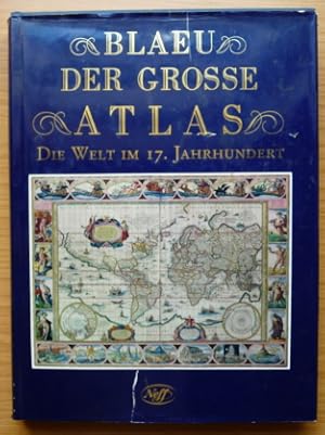
BLAEU- Der grosse Atlas: Die Welt im 17. Jahrhundert. Einführung, Texte und Auswahl der Karten von John Goss, ehemaliger Berater für Kartographie bei Sothebys ; Vorwort von Peter Clark, Konservator der Royal Geographical Society, London ; herausgegeben in Zusammenarbeit mit der Royal Geographical Society, London
Vendeur : Versandantiquariat Gebraucht und Selten, Mülheim a.d. Ruhr, NRW, Allemagne
Évaluation du vendeur 5 sur 5 étoiles

Edition originale
EUR 20
Autre deviseEUR 12,50 expédition depuis Allemagne vers FranceQuantité disponible : 1 disponible(s)
Ajouter au panierEtat : Sehr gut. 1. Aufl., Deutsche Erstausgabe,. 224 S.; überwiegend farbige Abbildungen auf Tafeln, "Der 'Atlas Major'. der 'Große Atlas', 1662 von dem Landkartenverleger Joan Blaeu herausgegeben, ist bis heute der umfangreichste Atlas, der jemals publiziert wurde. Seine mehr als 600 Landkarten geben ein anschauliches und umfassendes Bild der Welt, wie sie um die Mitte des 17. Jh. bekannt war. Die außerordentlich sorgfältig gearbeiteten Karten mit ihren zahlreichen Schmuckelementen, deren Schönheit und liebevolle Detailgenauigkeit ihresgleichen sucht, bilden das Prunkstück der Amsterdamer Landkartenherstellung.Die vorliegende Auswahl enthält 100 der wichtigsten und schönsten Landkarten aus dem 'Atlas Major', die mit Hilfe modernster Technik reproduziert wurden. Als Vorlage diente eine ausgabe des Atlas, die sich im Besitz der Royal Geographical Society in London befindet." (Klappentext) Sehr gutes Exemplar. Versand als versichertes Paket mit angepassten Versandkosten Sprache: Deutsch Gewicht in Gramm: 2635 Fol., 39/30/3cm, gebundene Ausgabe, blauer, farbig illustrierter OU, blaue OPp mit goldgeprägtem Deckel und Rücken.
-
Blaeu - Der grosse Atlas: die Welt im 17. Jahrhundert. Einführung, Texte und Auswahl der Karten von John Goss, ehemaliger Berater für Kartographie bei Sotheby's ; Vorwort von Peter Clark, Konservator der Royal Geographical Society, London ; herausgegeben in Zusammenarbeit mit der Royal Geographical Society, London
Vendeur : Elops e.V. Offene Hände, Bad Windsheim, Allemagne
Évaluation du vendeur 5 sur 5 étoiles
EUR 15
Autre deviseEUR 20 expédition depuis Allemagne vers FranceQuantité disponible : 1 disponible(s)
Ajouter au panierFesteinband, 39 cm. 224 S.; farbige Karten Schutzumschlag mit Läsuren und Einrissen; Einband bestoßen und gering lichtrandig Sprache: Deutsch Gewicht in Gramm: 2561.
-
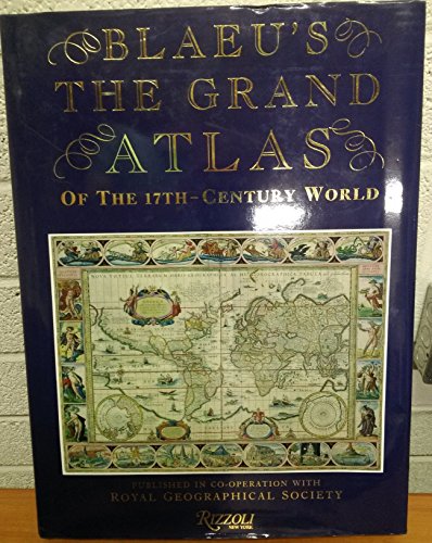
Blaeu's The Grand Atlas of the 17th-Century World
Vendeur : Sequitur Books, Boonsboro, MD, Etats-Unis
Membre d'association : IOBA
Évaluation du vendeur 5 sur 5 étoiles
EUR 26,39
Autre deviseEUR 28,19 expédition depuis Etats-Unis vers FranceQuantité disponible : 1 disponible(s)
Ajouter au panierhardcover. Etat : Very Good. 224 pages : color maps ; 39 cm. Hardcover and dust jacket. Good binding and cover. Clean, unmarked pages. This is an oversized or heavy book, which requires additional postage for international delivery outside the US.
-

Blaeu's The grand atlas of the 17th century world / introduction, captions, and selection of maps by John Goss ; foreword by Peter Clark
Edition originale
EUR 48
Autre deviseEUR 9,95 expédition depuis Irlande vers FranceQuantité disponible : 2 disponible(s)
Ajouter au panierFirst Edition. Fine cloth copy in a near fine, very slightly edge-nicked and dust-dulled dust wrapper, now mylar-sleeved. Remains particularly and surprisingly well-preserved; tight, bright, clean and sharp-cornered. Physical description; 1 atlas (224 pages) : color maps ; 37 cm. Notes; "The original maps . first appeared in Dr. Joan Blaeu's 'Atlas major, ' published in Amsterdam in 1662"--Title page verso. "Published in cooperation with the Royal Geographical Society, London." Includes bibliographical references (page 224). Introduction and commentary in English, maps in Latin. Subjects; Blaeu, Joan (1596-1673). Atlas maior. Atlases Early works to 1800 ; Facsimiles. Civilization, Modern 17th century ; Maps. Early maps ; Facsimiles. Cartography History. History of cartography ; [Literature]. Atlases. Cartography. Civilization, Modern. Early maps. Atlases Netherlands ; Early works to 1800 ; Facsimiles. Classical geography ; Maps. Geography, Ancient ; Maps. Historical geography ; Maps. Geography, Medieval ; Maps. Atlases, Dutch. History of cartography. ; [Literature] 1990. Atlases Netherlands. Atlases Netherlands ; Early works to 1800. World maps To 1800. Atlases ; Early works to 1800. World - ; Atlases 1662 (1997). Maps. Atlases. World. Atlases 17th century. Maps 17th century. World Facsimiles 1662 Atlases. Scales differ. Genres; cartographic image. Early works. Facsimiles. History. Maps. 2 Kg.
-
Blaeu's the Grand Atlas of the 17th Century World
Edité par Rizzoli Intl Pubns, New York, New York, U.S.A., 1991
ISBN 10 : 0847813002 ISBN 13 : 9780847813001
Langue: anglais
Vendeur : Jay W. Nelson, Bookseller, IOBA, Austin, MN, Etats-Unis
Membre d'association : IOBA
Évaluation du vendeur 4 sur 5 étoiles

EUR 33,44
Autre deviseEUR 29,90 expédition depuis Etats-Unis vers FranceQuantité disponible : 1 disponible(s)
Ajouter au panierHardcover. Etat : Near Fine. Etat de la jaquette : Near Fine.
-
Blaeu's the Grand Atlas of the 17th Century World
Edité par Rizzoli International Publications, New York, 1991
ISBN 10 : 0847813002 ISBN 13 : 9780847813001
Langue: anglais
Vendeur : Book Stall of Rockford, Inc., Rockford, IL, Etats-Unis
Membre d'association : MWABA
Évaluation du vendeur 5 sur 5 étoiles
EUR 33
Autre deviseEUR 40,15 expédition depuis Etats-Unis vers FranceQuantité disponible : 1 disponible(s)
Ajouter au panierHardcover. Etat : As New. Etat de la jaquette : Near Fine. Over-sized hardbound (folio). No wear to the binding. No distortion from reading or improper shelving. Pages tight and clean with no marks. Remainder mark bottom edge of the text block. No name of previous owner. No odor. No water damage. No soiling. The dust jacket shows no edge wear, two half inch tears bottom of rear panel, no sun fading. DJ in an archival protector.
-

Blaeu. De grote Atlas van de wereld in de 17e eeuw. Inleiding, aanvullende teksten en selectie van de kaarten: John Goss. [.]. Voorwoord: Peter Clark. [.].
Vendeur : Antiquariaat A. Kok & Zn. B.V., Amsterdam, Pays-Bas
Membre d'association : ILAB NVVA
Évaluation du vendeur 4 sur 5 étoiles
EUR 19,25
Autre deviseEUR 15,95 expédition depuis Pays-Bas vers FranceQuantité disponible : 1 disponible(s)
Ajouter au panier[Lisse] Zuid Boekproducties, [1997]. 224 pp. Col. maps. orig. hardcover (blue cloth, gilt lettered on spine), d./j. Small folio.
-

Blaeu: de grote atlas van de wereld in de 17e eeuw
Edité par Veltman Uitgevers B.V., 2000
ISBN 10 : 9062489311 ISBN 13 : 9789062489312
Langue: néerlandais
Vendeur : Mooney's bookstore, Den Helder, Pays-Bas
Évaluation du vendeur 4 sur 5 étoiles
EUR 45,70
Autre deviseEUR 7,95 expédition depuis Pays-Bas vers FranceQuantité disponible : 1 disponible(s)
Ajouter au panierEtat : Very good.
-
Grand Atlas of the Seventeenth Century World
Vendeur : WorldofBooks, Goring-By-Sea, WS, Royaume-Uni
Évaluation du vendeur 5 sur 5 étoiles
EUR 58,94
Autre deviseEUR 17,18 expédition depuis Royaume-Uni vers FranceQuantité disponible : 2 disponible(s)
Ajouter au panierPaperback. Etat : Very Good. The book has been read, but is in excellent condition. Pages are intact and not marred by notes or highlighting. The spine remains undamaged.
-
Blaeu's the Grand Atlas of the 17th Century World
Edité par Rizzoli Intl Pubns, New York, New York, U.S.A., 1991
ISBN 10 : 0847813002 ISBN 13 : 9780847813001
Langue: anglais
Vendeur : Michael J. Toth, Bookseller, ABAA, Springtown, PA, Etats-Unis
Membre d'association : ABAA ILAB
Évaluation du vendeur 5 sur 5 étoiles
Edition originale
EUR 57,20
Autre deviseEUR 25,59 expédition depuis Etats-Unis vers FranceQuantité disponible : 1 disponible(s)
Ajouter au panierHard Cover. Etat : Near Fine. Etat de la jaquette : Near Fine. First Edition. Tight, clean copy of this great colorful book of maps of the 17th Century. Another fine Rizzoli offering. 224 pp. Size: Folio - over 12" - 15" tall.
-
Blaeu's the Grand Atlas of the 17th Century World
Edité par Rizzoli International Publications February 1991, 1991
ISBN 10 : 0847813002 ISBN 13 : 9780847813001
Langue: anglais
Vendeur : Hennessey + Ingalls, Los Angeles, CA, Etats-Unis
Évaluation du vendeur 4 sur 5 étoiles
EUR 21,96
Autre deviseEUR 64,07 expédition depuis Etats-Unis vers FranceQuantité disponible : 1 disponible(s)
Ajouter au panierHardcover. Etat : Used - Very Good. Open copy with mild wear, clean pages with tight binding, dust jacket has noticeable wear (scuffing, creasing) on back cover and is wrapped in complimentary Brodart protector.
-
Blaeu's the Grand Atlas of the 17th Century World
Edité par Rizzoli New York 1990, 1990
Vendeur : Andrew Barnes Books / Military Melbourne, Melbourne, VIC, Australie
Évaluation du vendeur 4 sur 5 étoiles
Edition originale
EUR 40,83
Autre deviseEUR 18,80 expédition depuis Australie vers FranceQuantité disponible : 1 disponible(s)
Ajouter au panier1st edition hardback with dust jacket Nice copy folio 224pp., colour maps, bibliog., 100 double-page coloured maps. Published in co-operation with Royal Geographical Society. Minor rubbing to dust jacket at edges o/w nice copy.
-
![Image du vendeur pour Joan Blaeu. Wielki atlas XVII-wiecznego swiata [wydanie polskie] mis en vente par Antiquariat Weber](https://pictures.abebooks.com/inventory/md/md32124521985.jpg)
Joan Blaeu. Wielki atlas XVII-wiecznego swiata [wydanie polskie]
Edité par Panstwowe Przedsiebiorstwo Wydawnictw Kartograficznych im. E. Romera, Warszawa/Wroclaw, 1992
ISBN 10 : 8370000789 ISBN 13 : 9788370000783
Langue: polonais
Vendeur : Antiquariat Weber, Hamburg, HH, Allemagne
Membre d'association : GIAQ
Évaluation du vendeur 5 sur 5 étoiles
EUR 39
Autre deviseEUR 9 expédition depuis Allemagne vers FranceQuantité disponible : 1 disponible(s)
Ajouter au panier39 x 29 cm ; Pp. ; Etat : Gut. 224 S. ; Wstep i opisy map John Goss. Przedmowa Peter Clark. Großformatige polnischsprachige Hardcoverausgabe mit Schutzumschlag, 224 Seiten mit zahlreichen farbigen Karten. Schutzumschlag etwas angerändert. Gutes Exemplar. hw668 ISBN: 8370000789.
-
Blaeu's Atlas of the 17th Century World
Edité par Studio / Royal Geographical Society, 1997
ISBN 10 : 1858915880 ISBN 13 : 9781858915883
Vendeur : Tacoma Book Center, Tacoma, WA, Etats-Unis
Évaluation du vendeur 4 sur 5 étoiles
EUR 48,40
Autre deviseEUR 59,80 expédition depuis Etats-Unis vers FranceQuantité disponible : 1 disponible(s)
Ajouter au panierHardcover. Etat : Fine. Later Edition. ISBN 1858915880. Hardback. Reprint edition. Very Good to Near Fine condition book, with slight dustsoiling to top edge of book, in a Very Good to Near Fine condition dustjacket. Tight, bright, attractive copy with no markings to the book. Circular sticker over price on front jacket flap. Oversized.
