Montant total (1 article articles) :
Destination de la commande :

blaskowitz charles (2 rÈsultats)
Commentaires
Passer aux rÈsultats principaux de la recherche
Filtres de recherche
Type d'article
- Tous les types de produits
- Livres (1)
- Magazines & PÈriodiques (Aucun autre rÈsultat ne correspond ‡ ces critËres)
- Bandes dessinÈes (Aucun autre rÈsultat ne correspond ‡ ces critËres)
- Partitions de musique (Aucun autre rÈsultat ne correspond ‡ ces critËres)
- Art, Affiches et Gravures (Aucun autre rÈsultat ne correspond ‡ ces critËres)
- Photographies (Aucun autre rÈsultat ne correspond ‡ ces critËres)
- Cartes (1)
- Manuscrits & Papiers anciens (Aucun autre rÈsultat ne correspond ‡ ces critËres)
Etat En savoir plus
- Neuf (Aucun autre rÈsultat ne correspond ‡ ces critËres)
- Comme neuf, TrËs bon ou Bon (Aucun autre rÈsultat ne correspond ‡ ces critËres)
- Assez bon ou satisfaisant (2)
- Moyen ou mauvais (Aucun autre rÈsultat ne correspond ‡ ces critËres)
- ConformÈment ‡ la description (Aucun autre rÈsultat ne correspond ‡ ces critËres)
Reliure
- Toutes
- Couverture rigide (Aucun autre rÈsultat ne correspond ‡ ces critËres)
- Couverture souple (Aucun autre rÈsultat ne correspond ‡ ces critËres)
ParticularitÈs
- Ed. originale (1)
- SignÈ (1)
- Jaquette (Aucun autre rÈsultat ne correspond ‡ ces critËres)
- Avec images (2)
- Sans impressions ‡ la demande (2)
Langue (1)
Prix
- Tous les prix
- Moins de EUR 20 (Aucun autre rÈsultat ne correspond ‡ ces critËres)
- EUR 20 ‡ EUR 45 (Aucun autre rÈsultat ne correspond ‡ ces critËres)
- Plus de EUR 45
Livraison gratuite
Pays
Evaluation du vendeur
-
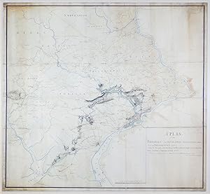
A Plan of the Progres of the Royal Army from their Landing at Elk Ferry to Philadelphia 1777 Under the Command of His Excellency, Sir William Howe Knight of the most Honorable Order of the Bath, Commander in Chief &ca &ca &ca Surveyd and Drawn by Order of Major General Sir William Erskine &c &c &c By Charles Blaskowitz, Capt of the Corps Guides
EditÈ par [Philadelphia], 1778
Vendeur : Arader Books, New York, NY, Etats-Unis
…valuation du vendeur 5 sur 5 Ètoiles

Carte Edition originale SignÈ
EUR 1†474†353,52
Autre deviseGratuit expÈdition vers Etats-UnisQuantitÈ disponible : 1 disponible(s)
Ajouter au panierNo binding. Etat : Very good. First. ONE OF THREE SURVIVING HEADQUARTERS MAPS FOR THE PHILADELPHIA CAMPAIGN, AND THE ONLY ONE MADE DURING THE CAMPAIGN. Manuscript map at a scale of 2 miles to 1 inch. [Philadelphia, ca. 1778]. Twelve sheets joined (outer borders: 51 3/8" x 53 1/8", 1305mm x 1350mm). Black and sanguine ink, hand-colored. Mounted on linen. Framed to full museum specifications. Some peripheral soiling. Repairs to the joins and some edge-tears, including a small marginal loss. Early in the Revolutionary War, the Commander-in-Chief of the British land forces, General William Howe, believed that the capture of the young nation's capital, Philadelphia, would demoralize the rebels to the point of laying down their arms. It was with high hopes for victory in the war, then, that British forces under Howe landed at Elk Ferry (now Elkton, Maryland), south of Philadelphia, on August 25, 1777, with the goal of taking the capital and crushing the Continental Army commanded by George Washington. This manuscript map by Charles Blaskowitz (c.1743-1823), the preeminent surveyor of the British campaign, shows the movements of the British forces as they marched and fought their way from Elk Ferry towards Philadelphia, indicating with red lines the routes of the British troops under Howe, the British and Hessian troops under Charles Cornwallis, and the Hessian auxiliaries under Wilhelm von Knyphausen. Our map illustrates how vital cartography was to the waging of war. Blaskowitz, for example, marks the location of the cheveaux de frise that the American forces had set up in the Delaware River to prevent British ships from approaching Philadelphia; Washington used the same tactics in the Hudson, adding two huge chain booms. Other maps show some of these same things -- William Faden made a manuscript map in 1777 "exhibiting the several works erected by the rebels" in the river -- but our map is of signal historical importance for being one of just three surviving large-format "Headquarters Maps" from the Philadelphia Campaign, and the only one made during the campaign. Blaskowitz's map shows more detail, particularly of the road network, taverns, and meeting houses, than the two maps that he probably used as sources: Nicholas Scull and George Heap's map of Philadelphia and its surroundings, first published in 1752, and Scull's map of southeastern Pennsylvania of 1759. Blaskowitz's map includes a much larger area than that of the campaign proper. Compare, for instance, the map of the same campaign made by John AndrÈ (Progress of the British Army from the landing in Elk River to the taking possession of Philadelphia, anno 1777: Huntington Library HM 3086r): it includes no more territory than necessary to show the route of the army to Philadelphia. Blaskowitz made his map for General Sir William Erskine (1728-1795), who participated in the Philadelphia Campaign, and for whom Blaskowitz has previously made a map of the New York Campaign in 1776 (Richard H. Brown Revolutionary War Map Collection at Mount Vernon). Usually in the eighteenth century the taking of an enemy's capital entailed the end of the war, but this was not the case after the British took Philadelphia. The Continental Congress had left the city for Lancaster before the British arrived, and in any case, the British capture of Philadelphia did not bring any important strategic advantages. In fact, Washington used the winter of 1777-78 to train the Continental Army into a much more expert fighting force. The high hopes that the British had for the Philadelphia Campaign when Blaskowitz began depicting it on his map were not achieved, and the war continued for another six years. Purchased at Christie's New York (7 December 2012, "Property of Mrs. M. Sharpe Erskine's Trust," lot 64). Catalogued by Mr. Chet van Duzer, revised by JL Rosenberg (D.Phil, Oxon.).
-
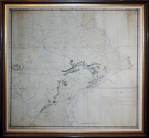
A Plan of the Progress of the Royal Army from their Landing at Elk Ferry to Philadelphia 1777 Under the Command Of His Excellency, Sir William Howe Knight of the most Honorable Order of the Bath, Commander and Chief
EditÈ par Surveyed and Drawn by Order of Major General Sir William Erskine by Charles Blaskowitz Capt. of the Corps Guide, 1778
Vendeur : Arader Galleries of Philadelphia, PA, Philadelphia, PA, Etats-Unis
…valuation du vendeur 4 sur 5 Ètoiles

EUR 1†404†146,21
Autre deviseEUR 3,83 expÈdition vers Etats-UnisQuantitÈ disponible : 1 disponible(s)
Ajouter au panierNo Binding. Etat : Very Good. Charles Blaskowitz (c.1743- 1823) A Plan of the Progress of the Royal Army from their Landing at Elk Ferry to Philadelphia 1777 Under the Command Of His Excellency, Sir William Howe Knight of the most Honorable Order of the Bath, Commander and Chief Surveyed and Drawn by Order of Major General Sir William Erskine by Charles Blaskowitz Capt. of the Corps Guide Published Philadelphia, 1778 On laid paper, mounted on linen Size: 51 3/8 x 53 1/8ø Blaskowitzøs map presents a highly accurate and detailed description of southeastern Pennsylvania and the adjacent parts of Maryland, Delaware and New Jersey. All rods and villages are illustrated with ink and watercolor. A detailed topographic projection crosses the lower half of the map moving northwards from the head of the Chesapeake Bay to Philadelphia. This marks the route of the British army as it progressed against determined Continental resistance to seize the American capital in September 1777. The site of the two large field battles, Brandywine and Germantown, are illustrated, as is the siege of Fort Mifflin in the Delaware River. Daily progress is tracked, and its locations of country taverns and meetinghouses are labeled, while crossed swords indicate the locations of skirmishes and red bars show the placement of brigades. It is a complete rendering of the dramatic sequence of events as they occurred from August to December 1777. The areas in the vicinity of the route of the British armies are rendered in full topographical detail, while the remainder of the map takes on the form of a road and administrative map. As indicated on the title, Blaskowitz drafted the map under the orders of Major General Sir William Erskine (1728-1795), one of the most highly regarded commanders in the British Army. At the time it was created, it was likely the most detailed and precise map of southeastern Pennsylvania. The map is a detailed record of the British campaign to take Philadelphia, the capital of the United States, during the late summer and autumn of 1777.