Clason map (32 résultats)
 Autres images
Edité par Clason Map Company 1918
- Carte
Vendeur : Live Oak Booksellers, Langley, WA, Etats-UnisLive Oak Booksellers
Contacter le vendeurVendeur avec une évaluation de 5 étoilesEtat: Occasion - Assez bon
EUR 67,42
EUR 3,49 expéditionExpédition nationale : Etats-UnisQuantité disponible : 1 disponible(s)
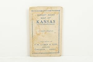
No Binding. Etat : Very Good. 13 x 7" map printed in color on one side that folds to about 2 x 3" and fits into a stiff card folder printed in blue. Front panel of card folder has the following information: "Compliments of F.M. Luther & Sons Brokers, Cimarron, Kansas." Map is in near fine condition with one short separation clos…ed with archival repair and no markings. Card stock folder slightly worn and slightly soiled. The Clason Map Company operated in Denver from the early 1900s until the Depression. It published numerous maps in different forms, including a "midget map" series. The distributor of this map, F. M. Luther & Sons, was a real estate brokerage headed by Francis [Frank] Luther, one of the founders of Cimarron, Kansas. I dated this map using a couple of named Kansas highways. The Carrie Nation Highway was established in 1917 and is shown on this map; but this map lacks a "Victory Highway" which was designated ca. 1921. A relatively rare map of Kansas.

Edité par The Clason Map Co.,, Denver, Colorado 1885
- Édition originale
- Carte
Vendeur : T. W. Palmer Books, Eugene, OR, Etats-UnisT. W. Palmer Books
Contacter le vendeurVendeur avec une évaluation de 5 étoilesEtat: Occasion - Assez bon
EUR 67,42
EUR 4,36 expéditionExpédition nationale : Etats-UnisQuantité disponible : 1 disponible(s)
No Binding. Etat : Very Good. No Jacket. 1st Edition. 46 x 61 cm, thin paper was folded small, colored in outline , roads, railroads in red, inset of St. Louis and Vicinity, [ on right side of map] INDEX MISSOURI, Cities and Towns with Population of 700 or More Date is roughly estimated from map contents. Many original folds, a…few separations on horizontal folds and some stains on back which leak through lightly.
 Autres images
Edité par The Clason Map Co 1914
- Couverture souple
- Édition originale
Vendeur : Arundel Books, Seattle, WA, Etats-UnisArundel Books
Contacter le vendeurVendeur avec une évaluation de 5 étoilesEtat: Occasion - Bon
EUR 107,87
EUR 5,02 expéditionExpédition nationale : Etats-UnisQuantité disponible : 1 disponible(s)
Saddle-stapled wraps. Etat : Near Fine. First Edition. 16mo - over 5¾" - 6¾" An exceptional copy of this scarce early California motoring guide with the large folding color map, in the original green wraps printed in black and yellow. A nice, crisp copy with the map cross-folded with one minor tear; in Near Fine condition.
 Autres images
Edité par Denver & Chicago c.1925, Denver & Chicago 1925
- Couverture souple
Vendeur : High Ridge Books, Inc. - ABAA, South Deerfield, MA, Etats-UnisHigh Ridge Books, Inc. - ABAA
Contacter le vendeurVendeur avec une évaluation de 5 étoilesEtat: Occasion
EUR 134,84
EUR 7,94 expéditionExpédition nationale : Etats-UnisQuantité disponible : 1 disponible(s)
31x21.5 cm. Illustrated colored wrappers. Good to very good condition with wear and rubbing at sides. 48 pp. Uncolored maps of each of the United States plus southern Ontario and Quebec. Clason was a significant map publisher of the early 20th century, generally focused on the western United States. Their atlases, mostly from th…e 1920's, are quite scarce. See Rumsey 13359 for what appears to be the same atlas with a different name and wrappers.
Edité par Chicago & Denver c. 1925, Chicago & Denver 1925
- Couverture souple
Vendeur : High Ridge Books, Inc. - ABAA, South Deerfield, MA, Etats-UnisHigh Ridge Books, Inc. - ABAA
Contacter le vendeurVendeur avec une évaluation de 5 étoilesEtat: Occasion
EUR 134,84
EUR 7,94 expéditionExpédition nationale : Etats-UnisQuantité disponible : 1 disponible(s)
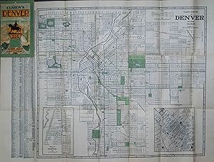
Folding map in Clason's Denver Map Guide. Stiff illustrated wrappers in very good condition, with light wear at edges. Includes 40 pp. text with street name index, extensive descriptions of notable sites, buildings and parks in the city, with a double-page plan of the tramway routes and a single-page map of the business district….
 Autres images
Edité par Denver c.1912, Denver 1912
- Couverture souple
Vendeur : High Ridge Books, Inc. - ABAA, South Deerfield, MA, Etats-UnisHigh Ridge Books, Inc. - ABAA
Contacter le vendeurVendeur avec une évaluation de 5 étoilesEtat: Occasion
EUR 157,31
EUR 7,94 expéditionExpédition nationale : Etats-UnisQuantité disponible : 1 disponible(s)
43x55 cm. Folding map in original stiff illustrated wrappers, near mint condition. 56 pp. text. Rail lines are highlighted in red. The text (16x10 cm.) contains single-page uncolored maps of the business districts of Denver, Colorado Springs and Pueblo.
Edité par Chicago, Chicago 1924
- Couverture souple
Vendeur : High Ridge Books, Inc. - ABAA, South Deerfield, MA, Etats-UnisHigh Ridge Books, Inc. - ABAA
Contacter le vendeurVendeur avec une évaluation de 5 étoilesEtat: Occasion
EUR 157,31
EUR 7,94 expéditionExpédition nationale : Etats-UnisQuantité disponible : 1 disponible(s)
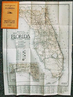
Small folding map in fine condition. Stiff orange printed wrappers, 1924-25 calendar inside front cover, ad for Merchant's Bank and Trust Co. of Daytona on the back cover. The map, lightly tinted, shows the road system of Florida, with "best roads" and "other thoroughfares" identified. Distances between towns is noted. The panha…ndle is shown on an inset map. The map also keys the nine different signs which designate the major roads through the state. These signs were posted periodically on poles along these routes. Index of towns, with populations, at the bottom. While Clason was a major maker of maps during this period, most of their maps dealt with areas west of the Mississippi River.
 Autres images
Edité par The Clason Map Company, n. d. (ca 1920)., Chicago, Denver 1920
- Couverture souple
Vendeur : BUCKINGHAM BOOKS, ABAA, ILAB, IOBA, GREENCASTLE, PA, Etats-UnisBUCKINGHAM BOOKS, ABAA, ILAB, IOBA
Contacter le vendeurVendeur avec une évaluation de 5 étoilesEtat: Occasion
EUR 157,31
EUR 13,53 expéditionExpédition nationale : Etats-UnisQuantité disponible : 1 disponible(s)
[NEVADA]. 6 1/4" x 4" green pictorial stiff wrappers printed in black,16 pp., index to Nevada towns, state and city maps, automobile road logs, railroads, hotels, industries, altitudes, population, etc. A fold-out map at the front presents a mileage map of the transcontinental trails of the United States on one side and on the o…ther side a mileage map of the best roads of California and Nevada. Affixed to the rear cover is a color map of Nevada. Both maps are in fine condition. Covers lightly used and rubbed , else a very good copy with light wear to the spine ends and corners.
 Autres images
Edité par Denver c.1910, Denver 1910
- Couverture rigide
Vendeur : High Ridge Books, Inc. - ABAA, South Deerfield, MA, Etats-UnisHigh Ridge Books, Inc. - ABAA
Contacter le vendeurVendeur avec une évaluation de 5 étoilesEtat: Occasion
EUR 179,79
EUR 7,94 expéditionExpédition nationale : Etats-UnisQuantité disponible : 1 disponible(s)
Very small uncolored map of New Mexico. Folds into 8.5x5 cm. printed boards. Two short tears mended. Small stains on boards. Issued as a promotional item for the Alamo Real Estate Loan and Insurance Co. of Alamogordo, New Mexico. This small map is considerably rarer than the larger Clason series of maps of western states.
 Autres images
Edité par The Clason Map Company, 1911., Denver 1911
- Couverture souple
Vendeur : BUCKINGHAM BOOKS, ABAA, ILAB, IOBA, GREENCASTLE, PA, Etats-UnisBUCKINGHAM BOOKS, ABAA, ILAB, IOBA
Contacter le vendeurVendeur avec une évaluation de 5 étoilesEtat: Occasion
EUR 175,29
EUR 13,53 expéditionExpédition nationale : Etats-UnisQuantité disponible : 1 disponible(s)
[UTAH]. 6 1/4" x 4" green pictorial stiff wrappers printed in black, 32 pp., index to Utah towns, rivers and creeks, mountains and peaks, valleys and deserts, lakes, plus railroad distances and railroad distances between Utah towns. The color fold-out map of Utah is bight and and colorful. 3" closed split to lower edge of map at… fold as well as 1/2" closed split to top edge of map at fold. Folder is clean and tight.
 Autres images
Edité par Los Angeles: Security Trust & Savings Bank, 1921 1921
- Couverture souple
- Carte
Vendeur : James Arsenault & Company, ABAA, Arrowsic, ME, Etats-UnisJames Arsenault & Company, ABAA
Contacter le vendeurVendeur avec une évaluation de 5 étoilesEtat: Occasion
EUR 247,21
EUR 8,07 expéditionExpédition nationale : Etats-UnisQuantité disponible : 1 disponible(s)
Brochure incorporating three maps, 7" x 3.75" folded; sheet size 28" x 21", single map printed on one side (24" x 20.5"), text and two maps on verso, one map 18" x 13" and other 20.5" x 6.5". CONDITION: Very good, a few small holes at folds, toning and two inch separation along one fold. A map brochure issued by the Security Tru…st and Savings Bank of Los Angeles, intended to promote the city, to advertise the bank, and to closely identify the growth of the city with the growth of the bank. Appearing on the recto is "The Map of the City of Los Angeles" extending from Griffith Park in the north to the beginning of the "Shoestring" strip in the south, and west from Huntington Avenue to the (former) intersection of Sunset Boulevard and Holloway Drive. Four capitalized letters indicate "The Four Security Corners," ie., where the four branches of the Security Trust and Savings Bank can be found. One is located "in the heart of the Downtown Section," another serves "the Ninth End of the Business District," another is available near the "West End of the Shopping District," and the fourth, the "Cahuenga Building," is the "largest Banking Institution in Hollywood." Numbers along the border mark the thoroughfares from Los Angeles to nearby towns and neighborhoods including Los Angeles' Harbor, San Francisco, San Diego, Culver City, and Redondo Beach. All of these are identified in a key below the map. There is an additional inset map on the right edge ("Insert A"), an enlarged view of the neighborhoods around Huntington Avenue. On the verso is a map of the "Complete City of Los Angeles" showing the entirety of Los Angeles including the Shoestring addition of 1909, as well as un-annexed towns and additions in the greater L.A. region. Also included is a map of"the Shoestring" and Los Angeles Harbor accompanied by a note on its history. Other notes cover such matters as "Growth of the City and the Growth of the Bank," the square mileage covered by the city, and its internal improvements, especially the construction of its aqueduct. The Security Trust and Savings Bank was a prominent financial institution in late nineteenth and early twentieth century Los Angeles and served as "one of the principal banks used by Hollywood for financing films (including those of Cecil B. DeMille), and for maintaining personal fortunes (Howard Hughes, Charlie Chaplin, and W. C. Fields are said to have had accounts at this bank)" ("Security Trust"). Their Cahuenga building in Hollywood was the tallest building in Hollywood in 1921, serving as a popular filming location of the silent film era. In fact, Raymond Chandler gave his iconic private eye, Philip Marlowe, an office there "on the sixth floor, two small rooms at the back. One I left open for a patient client to sit in, if I had a patient client" ("Cahuenga Building"). REFERENCES: "Cahuenga Building" at Atlas Obscura online; "Security Trust and Savings Bank, California," at Center for Land Use and Interpretation online.
 Autres images
Edité par The Clason Map Company 1920
- Couverture souple
- Carte
Vendeur : Barry Lawrence Ruderman, La Jolla, CA, Etats-UnisBarry Lawrence Ruderman
Contacter le vendeurVendeur avec une évaluation de 5 étoilesEtat: Occasion - Assez bon
EUR 355,08
EUR 12,65 expéditionExpédition nationale : Etats-UnisQuantité disponible : 1 disponible(s)
No Binding. Etat : VG. Early California road atlas, published by Edward Doheny's California Petroleum Corporation. Includes 4 larger road maps of sections of California and smaller city maps of major cities, including Los Angeles, San Die. Folding map. Covers somewhat toned and worn. Early California road atlas, published b…y Edward Doheny's California Petroleum Corporation. Includes 4 larger road maps of sections of California and smaller city maps of major cities, including Los Angeles, San Diego, Long Beach, San Francisco, Oakland, San Jose, Santa Barbara, Sacramento, Fresno, and the East Bay. Map.
 Autres images
Edité par Denver, Denver 1912
- Couverture souple
Vendeur : High Ridge Books, Inc. - ABAA, South Deerfield, MA, Etats-UnisHigh Ridge Books, Inc. - ABAA
Contacter le vendeurVendeur avec une évaluation de 5 étoilesEtat: Occasion
EUR 674,20
EUR 7,94 expéditionExpédition nationale : Etats-UnisQuantité disponible : 1 disponible(s)
A road atlas of Colorado designed for automobile drivers. Original illustrated stiff wrappers. Top and bottom of backstrip torn, otherwise excellent condition. 192 pp. with 84 uncolored maps and many photographic illustrations in the text. This was the first auto travel guide issued by a state governmental authority. Motor Age m…agazine for May 30, 1912: "Nearly half of the 192 pages of the book are devoted to maps, and the text pages are generaously illustrated with many of Colorado's most famous and wonderful scenes. The different routes are idnetified by the preservation of the names applied to them when they were old, historic trails." A rare and important piece of Colorado history from the earliest days of automobile travel in the American West. OCLC 18713787 (8 loc.).

- Couverture rigide
- impression à la demande
Vendeur : True World of Books, Delhi, , IndeTrue World of Books
Contacter le vendeurVendeur avec une évaluation de 5 étoilesEtat: Neuf
EUR 21,57
Frais de port gratuitsExpédition depuis Inde vers Etats-UnisQuantité disponible : 18 disponible(s)
LeatherBound. Etat : New. BOOKS ARE EXEMPT FROM IMPORT DUTIES AND TARIFFS; NO EXTRA CHARGES APPLY. LeatherBound edition. Condition: New. Reprinted from 1920 edition. Leather Binding on Spine and Corners with Golden leaf printing on spine. Bound in genuine leather with Satin ribbon page markers and Spine with raised gilt bands. A… perfect gift for your loved ones. Pages: 46 NO changes have been made to the original text. This is NOT a retyped or an ocr'd reprint. Illustrations, Index, if any, are included in black and white. Each page is checked manually before printing. As this print on demand book is reprinted from a very old book, there could be some missing or flawed pages, but we always try to make the book as complete as possible. Fold-outs, if any, are not part of the book. If the original book was published in multiple volumes then this reprint is of only one volume, not the whole set. Sewing binding for longer life, where the book block is actually sewn (smythe sewn/section sewn) with thread before binding which results in a more durable type of binding. Pages: 46.

- Couverture rigide
- impression à la demande
Vendeur : True World of Books, Delhi, , IndeTrue World of Books
Contacter le vendeurVendeur avec une évaluation de 5 étoilesEtat: Neuf
EUR 21,57
Frais de port gratuitsExpédition depuis Inde vers Etats-UnisQuantité disponible : 18 disponible(s)
LeatherBound. Etat : New. BOOKS ARE EXEMPT FROM IMPORT DUTIES AND TARIFFS; NO EXTRA CHARGES APPLY. LeatherBound edition. Condition: New. Reprinted from 1921 edition. Leather Binding on Spine and Corners with Golden leaf printing on spine. Bound in genuine leather with Satin ribbon page markers and Spine with raised gilt bands. A… perfect gift for your loved ones. Pages: 50 NO changes have been made to the original text. This is NOT a retyped or an ocr'd reprint. Illustrations, Index, if any, are included in black and white. Each page is checked manually before printing. As this print on demand book is reprinted from a very old book, there could be some missing or flawed pages, but we always try to make the book as complete as possible. Fold-outs, if any, are not part of the book. If the original book was published in multiple volumes then this reprint is of only one volume, not the whole set. Sewing binding for longer life, where the book block is actually sewn (smythe sewn/section sewn) with thread before binding which results in a more durable type of binding. Pages: 50.
Edité par Chicago & Denver c. 1919, Chicago & Denver 1919
Vendeur : High Ridge Books, Inc. - ABAA, South Deerfield, MA, Etats-UnisHigh Ridge Books, Inc. - ABAA
Contacter le vendeurVendeur avec une évaluation de 5 étoilesEtat: Occasion
EUR 134,84
EUR 7,94 expéditionExpédition nationale : Etats-UnisQuantité disponible : 1 disponible(s)
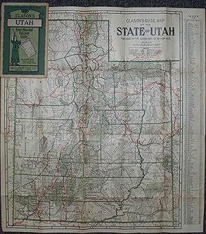
Folding map in Clason's Utah Green Guide. Very good condition, with light wear at edges and one short mended tear to the map. Includes 32 pp. text with place name index, lists of roads and railroads, descriptive information about the state, small uncolored maps of Salt Lake City and the roads into and out of the city. Map is bri…ghtly colored, with roads, railroads, and national forests highlighted. Dated from population figure in text.
 Autres images
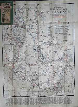
Edité par Chicago & Denver c. 1930, Chicago & Denver 1930
Vendeur : High Ridge Books, Inc. - ABAA, South Deerfield, MA, Etats-UnisHigh Ridge Books, Inc. - ABAA
Contacter le vendeurVendeur avec une évaluation de 5 étoilesEtat: Occasion
EUR 134,84
EUR 7,94 expéditionExpédition nationale : Etats-UnisQuantité disponible : 1 disponible(s)
Folding map in Clason's Idaho Green Guide. Very good condition, with light wear at edges and one short mended tear to the map. Includes 32 pp. text with place name index, lists of roads and railroads, descriptive information about the state, small uncolored map of Boise. The map is printed on both sides, with the general map on…one side and a Mileage Map of the Best Roads of Idaho on the other.
 Autres images
Edité par Chicago & Denver c.1927, Chicago & Denver 1927
Vendeur : High Ridge Books, Inc. - ABAA, South Deerfield, MA, Etats-UnisHigh Ridge Books, Inc. - ABAA
Contacter le vendeurVendeur avec une évaluation de 5 étoilesEtat: Occasion
EUR 157,31
EUR 7,94 expéditionExpédition nationale : Etats-UnisQuantité disponible : 1 disponible(s)
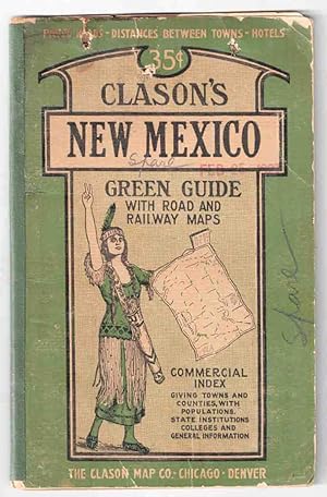
Folding map in Clason's New Mexico Green Guide. Good condition only, covers worn, old stains in top margin of text and along some folds of map. Three small punctures through the front cover, one through the text. Splits along maps folds mended. Includes 32 pp. text with place name index, lists of roads and railroads, descriptive… information about the state, small uncolored maps of Albuquerque and Santa Fe business districts. Map is brightly colored, with roads, railroads, reservations and national forests highlighted. Dated from population figure in text. The date of the map is not stated, but it is clearly after 1921 due to the presence of Harding and Catron Counties.

Edité par Chicago & Denver c. 1920, Chicago & Denver 1920
Vendeur : High Ridge Books, Inc. - ABAA, South Deerfield, MA, Etats-UnisHigh Ridge Books, Inc. - ABAA
Contacter le vendeurVendeur avec une évaluation de 5 étoilesEtat: Occasion
EUR 202,26
EUR 7,94 expéditionExpédition nationale : Etats-UnisQuantité disponible : 1 disponible(s)
Folding map in Clason's New Mexico Green Guide. fine condition, with light wear at edges and short tear at top of spine. Includes 28 pp. text with place name index, lists of roads and railroads, descriptive information about the state, small uncolored maps of Albuquerque and Santa Fe business districts. Map is brightly colored,…with roads, railroads, reservations and national forests highlighted. Dated from population figure in text. Also dated from the absence of Harding and Catron Counties, both of which were established in early 1921.
Edité par Denver Colorado The Company, 1918 1918
Vendeur : Franklin Gilliam :: Rare Books, A.B.A.A., Charlottesville, VA, Etats-UnisFranklin Gilliam :: Rare Books, A.B.A.A.
Contacter le vendeurVendeur avec une évaluation de 1 étoilesEtat: Occasion
EUR 247,21
EUR 3,93 expéditionExpédition nationale : Etats-UnisQuantité disponible : 1 disponible(s)
Single sheet, printed on one side only, 29 x 22 1/2 inches, folded to 5 3/4 x 3 1/2 inches. Printed gray stiff wrappers, front pictorial. The various advances by he allies on the Western Front are superimposed in red on the map, the latest being that of September 4, 1918.
 Autres images
Edité par Clason Map Co, Chicago 1925
- Carte
Vendeur : mediumraremaps.com, Franklin, TN, Etats-Unismediumraremaps.com
Contacter le vendeurVendeur avec une évaluation de 4 étoilesEtat: Occasion
EUR 292,15
EUR 5,24 expéditionExpédition nationale : Etats-UnisQuantité disponible : 1 disponible(s)
32 1/2 x 22 3/4 inches. Beautifully composed black and White map of the city of Chicago in very good condition. From Evanston on the north to Riverdale on the south, the map captures the grid system of streeting. From Lake Michigan on the east to Berwyn on the west side, the immensity of order set by the street makes the thought… of travel a simple task. This map tells you where your at and all the right angle turns you will make to reach your destination. This is a highly colorable map. Very good but having several separations at the folds. The map is still attached to the cover.
Edité par Clason Map Company: Compliments of the Tourist and Publicity Bureau of the Denver Chamber of Commerce, Denver 1920
- Carte
Vendeur : mediumraremaps.com, Franklin, TN, Etats-Unismediumraremaps.com
Contacter le vendeurVendeur avec une évaluation de 4 étoilesEtat: Occasion
EUR 1 348,40
EUR 5,24 expéditionExpédition nationale : Etats-UnisQuantité disponible : 1 disponible(s)
This is a superb cartographic artifact from the early years of automobile travel. The map is unusual in its large scale. Clason maps are generally a much smaller scale and usually state-centric. This map is rare with WorldCat locating two editions with a total of four copies. This map was used by a well travelled person. The use…r followed the trail system and marked the routes with blue and red markings. The pre-Federal highway numbering system of Trails dominates the map. The user travelled some trails more than once. Most prominent is the use of the National Old Trails road which was the predecessor to Route 66. Route 66 was introduced in 1926. The National Old Trails road was also known as the Coast-to-Coast highway. The road ran from Baltimore MD to Santa Monica, CA. This map's user travelled the most parts of the road. The Old Spanish Trail was traversed from St Augustine to San Diego. Red markings indicate the portions traveled each day. Multiple other trails were used as listed in the Trails index on the map, including the Oregon Trail.This map is a critical document in the history of transportation. It freezes a time where the consciousness of the traveling public had expanded and opened to the concept of transcontinental travel by car. The map's user chronicled that travel and the journeys are here recorded. The map is undated but WorldCat shows 1920 for the other non-Denver edition. This would be the same or only slightly thereafter. The period precedes heavy Federal involvement with the consciousness of long distance travel by car in its infancy. This is a rarity and an exception period documentation of the road well travelled. Good condition having been used as a travel document. Some tears at the fold intersection and overall mild soiling. The tears have been repaired with archival mending tape. Single sheet Wall Map measuring 32 x 26 inches WorldCat lists two editions with only four total locations found.
 Autres images
- Couverture rigide
- impression à la demande
Vendeur : Gyan Books Pvt. Ltd., Delhi, , IndeGyan Books Pvt. Ltd.
Contacter le vendeurVendeur avec une évaluation de 5 étoilesEtat: Neuf
EUR 29,37
Frais de port gratuitsExpédition depuis Inde vers Etats-UnisQuantité disponible : Plus de 20 disponibles
Leather Bound. Etat : New. Language: English. Language: English. Presenting an Exquisite Leather-Bound Edition, expertly crafted with Original Natural Leather that gracefully adorns the spine and corners. The allure continues with Golden Leaf Printing that adds a touch of elegance, while Hand Embossing on the rounded spine lends… an artistic flair. This masterpiece has been meticulously reprinted in 2025, utilizing the invaluable guidance of the original edition published many years ago in 1921. The contents of this book are presented in classic black and white. Its durability is ensured through a meticulous sewing binding technique, enhancing its longevity. Imprinted on top-tier quality paper. A team of professionals has expertly processed each page, delicately preserving its content without alteration. Due to the vintage nature of these books, every page has been manually restored for legibility. However, in certain instances, occasional blurriness, missing segments, or faint black spots might persist. We sincerely hope for your understanding of the challenges we faced with these books. Recognizing their significance for readers seeking insight into our historical treasure, we've diligently restored and reissued them. Our intention is to offer this valuable resource once again. We eagerly await your feedback, hoping that you'll find it appealing and will generously share your thoughts and recommendations. Lang: - English, Pages:- 50, Print on Demand. If it is a multi-volume set, then it is only a single volume. We are specialised in Customisation of books, if you wish to opt different color leather binding, you may contact us. This service is chargeable. Product Disclaimer: Kindly be informed that, owing to the inherent nature of leather as a natural material, minor discolorations or textural variations may be perceptible. Explore the FOLIO EDITION (12x19 Inches): Available Upon Request. 50 50.

- Carte
Vendeur : Geographicus Rare Antique Maps, Brooklyn, NY, Etats-UnisGeographicus Rare Antique Maps
Contacter le vendeurVendeur avec une évaluation de 4 étoilesEtat: Occasion
EUR 226,53
EUR 14,84 expéditionExpédition nationale : Etats-UnisQuantité disponible : 1 disponible(s)
Good. Wear along original fold lines. Edge wear. Closed margin tears professionally repaired on verso. Small areas of loss at a few fold intersections. Size 27.5 x 21 Inches. This is a 1924 Clason Map Company city plan or map of Los Angeles, California, issued for the Bank of Italy. Depicting from Griffith Park to Iowa Avenue an…d from Holt Street to the Flood Control Channel, streets throughout are labeled. Red overprinting highlights the four Bank of Italy branches in Los Angeles and red text provides the cross streets where each branch is located. A street index occupies both upper corners and the entire section below the border. Verso Content Two maps appear on the verso. One marks the location of every Bank of Italy branch by city. The larger of the two maps focuses on the greater Los Angeles area with red overprinting highlighting downtown Los Angeles where the Southern California Headquarters of the Bank of Italy was located. Publication History and Census This map was created and published by the Clason Map Company in 1924 and distributed by the Bank of Italy. We note one other cataloged example in private hands.

- Carte
Vendeur : Geographicus Rare Antique Maps, Brooklyn, NY, Etats-UnisGeographicus Rare Antique Maps
Contacter le vendeurVendeur avec une évaluation de 4 étoilesEtat: Occasion
EUR 352,38
EUR 14,84 expéditionExpédition nationale : Etats-UnisQuantité disponible : 1 disponible(s)
Good. Some wear along original fold lines. Professionally flattened and backed with archival tissue. Close left margin. Blank on verso. Size 28 x 32 Inches. This is a large and highly detailed c. 1920 Clason Map Company pocket format map of California. This map depicts the entire state of California with green highlighting to di…stinguish county borders and national forest lands. Inset submaps in the upper right and lower left quadrants focus on the San Francisco Bay area and the vicinity of Los Angeles, respectively. An index set along the map's left-hand border offers population statistics and a key to various cities throughout the state. Publication History and Census Issued by the Clason Map Company of Denver, Colorado and Chicago, Illinois. This map underwent many changes and revisions between 1920 and 1930, all editions of which are undated. The census data on the map correlates to the 1920 Federal Census, which is how the map was dated. While there are some bridges and such on the map that were not constructed as of 1920, it was common to included planed and anticipated bridges on maps to increase their longevity. Nonetheless, with a c. 1920 date, we are confidante that the map was issued sometime between 1920 and the next Federal Census in 1930. References: OCLC 176916412.

- Carte
Vendeur : Geographicus Rare Antique Maps, Brooklyn, NY, Etats-UnisGeographicus Rare Antique Maps
Contacter le vendeurVendeur avec une évaluation de 4 étoilesEtat: Occasion
EUR 402,72
EUR 14,84 expéditionExpédition nationale : Etats-UnisQuantité disponible : 1 disponible(s)
Very good. Slight wear along some fold lines. Some creases on the sleeve. Size 16 x 22 Inches. This is a very nice example of Clason's c. 1920 Washington State road and railway map. It highlights the state's infrastructure, while also showing information on national parks, Indian reservations, and administrative divisions. A Clo…ser Look The map includes a grid coordinate system in the margins corresponding to the index of settlements at right to allow for easy location of towns and cities. Dotted and dashed lines represent government surveying measurements, as shown in the legend. Government land (parks, forests) and Indian reservations constitute roughly half of the state's territory. Prominent near center is Mt. Rainier National Park, while other well-known mountains such as Baker (Kulshan), Adams (Klickitat), and Glacier Peak (Takobia) are easily identifiable. Road, rail, and steamship lines are clearly indicated, including connections to neighboring states and Canada, along with maritime connections to Alaska and East Asia. Publication History and Census This map very closely resembles Clason's 'Green Guide' for Washington but is an atypical example where the slip-sleeve advertises an automobile parts shop in Everett. The index is dated to 1920, a reference to the population figures in the census of that year, so the map may date from several years afterwards but in any event before 1930. The presentation, title, index, and legend resemble Clason maps of other western states dated to the late 1910s. This map may correspond to OCLC catalog listing 58875729, in which case it is held by five institutions in the United States and is very scarce to the market, with no catalog listings or history on the market matching this example with the aforementioned sleeve. References: OCLC 58875729.

- Carte
Vendeur : Geographicus Rare Antique Maps, Brooklyn, NY, Etats-UnisGeographicus Rare Antique Maps
Contacter le vendeurVendeur avec une évaluation de 4 étoilesEtat: Occasion
EUR 402,72
EUR 14,84 expéditionExpédition nationale : Etats-UnisQuantité disponible : 1 disponible(s)
Good. Wear along original fold lines. Verso repairs to fold separations and at fold intersections. Slight loss at some fold intersections. Size 18 x 22 Inches. This is a 1909 Clason Map Company city plan or map of Salt Lake City, Utah. The Temple Block, situated in the upper left, is labeled and the Temple, Tabernacle, and Assem…bly Hall are illustrated and labeled as well. Streets and city blocks are identified, along with the post office, Liberty Park, the State University of Utah (today's University of Utah), and the State Capital Grounds. Fort Douglas Military Reservation dominates the upper right quadrant with Newhouse Park just outside its boundaries. The City Cemetery, Hebrew Cemetery, Catholic Cemetery, and Mt. Olivet Cemetery are all labeled as well. Publication History and Census This map was created and published by the Clason Map Company in 1909. We have located no other cataloged examples of the 1909 edition of this map.

Vendeur : Art Source International Inc., Boulder, CO, Etats-UnisArt Source International Inc.
Contacter le vendeurVendeur avec une évaluation de 5 étoilesEtat: Occasion
EUR 444,97
EUR 13,96 expéditionExpédition nationale : Etats-UnisQuantité disponible : 1 disponible(s)
At the turn of the century, the Clason Map Company was an up and coming publisher that was growing and doing some of their best work. This map is a fine example of their quality. With their trademark simplicity and clarity, the Clason Map Company provided well-detailed work, which remained legible and aesthetically appealing. Th…is map shows detail for the hydrography, railways, and towns. This map of Kit Carson, Lincoln and Cheyenne Counties, Colorado shows Limon with distances to Colorado Springs and Denver. This map measures 32.5 inches by 27 inches.

- Édition originale
- Carte
Vendeur : Geographicus Rare Antique Maps, Brooklyn, NY, Etats-UnisGeographicus Rare Antique Maps
Contacter le vendeurVendeur avec une évaluation de 4 étoilesEtat: Occasion
EUR 453,06
EUR 14,84 expéditionExpédition nationale : Etats-UnisQuantité disponible : 1 disponible(s)
1st Edition. Very good. Light wear along original fold lines. Verso repairs to fold separations and at fold intersections. Closed edge tears professionally repaired on verso. Accompanied by original booklet. Size 16 x 23.75 Inches. This is a 1911 pocket map of Washington state prepared by the Clason Map Company, the earliest suc…h map of Washington prepared by the company. A Closer Look The state of Washington is displayed along with portions of Oregon, Idaho, and British Columbia. Red lines trace county boundaries, while black lines form a grid of latitude and longitude lines. Green shading denotes national forests. Cities and towns, mountains, waterways, and other features are labeled throughout. Railroads to the Pacific Rail lines, traced in black, stand out prominently, with the distances between stations recorded. Significantly, automobile roads are not noted, though they did exist. The state had established a Highway Board in 1905 and was working to improve existing dirt and gravel roads, but, as the map reflects, the vast majority of travelers continued to use railways, which had been built in profusion in the Pacific Northwest in the late 19th and early 20th century (note the density around Spokane in particular); in fact, the map displays several lines still under construction. Most of these lines belonged to two competing systems, the Great Northern Railway and the Northern Pacific Railroad. The Chicago, Milwaukee, and Puget Sound Railway, part of the larger 'Milwaukee Road' system, which had only reached Puget Sound a couple of years prior, is also indicated. The Oregon Railroad and Navigation Company that operated along the Columbia River had just become a subsidiary of the Union Pacific in 1910. The Canadian Pacific Railway appears near the top. Other lines, mostly local operations used for logging, are also traced. Many of these companies overbuilt their networks, spending millions to gain a slight advantage, and went deep into debt, leading to a raft of consolidation and closure of unprofitable lines in the early 20th century. American Indian Reservations The map also notes the location of several American Indian reservations, the largest of which are the Colville and Yakima (Yakama) Reservations. The former was and remains home to a mix of a dozen 'confederated tribes,' including the Chief Joseph band of Nez Piece. (The great chief died on the reservation in 1904.) Smaller reservations, such as the Hoh Indian Reservation along the Pacific coast of the Olympic Peninsula and the Lummi Reservation near Bellingham, are also indicated. At the end of the 19th century, following the 1887 Dawes Act (also known as the General Allotment Act), federal Indian policy shifted significantly towards cultural assimilation, including the allotment of land in private plots to encourage the adoption of a lifestyle similar to that of white settlers in the region. The implementation of these policies was often haphazard and inconsistent but generally disadvantaged Indians. It justified reducing the size of reservations (as happened to the Colville Reservation) to create opportunities for white settlers to acquire reservation land. Publication History and Census This map and guide were prepared by the Clason Map Company of Denver in 1911. It represents an early example of the iconic Clason 'Green Guides' that were produced into the 1930s. These pocket guides and maps are so called because of their distinctive green cover adorned with the image of a woman (Lady Liberty or a Native American woman, depending on the year). The present map was both the earliest Clason pocket map of Washington and the earliest 'Green Guide' for Washington. Later editions of the Clason 'Green Guide' for Washington were published every several years, and the lack of automobile roads here is especially notable since later 'Green Guides' prided themselves on providing up-to-date information on the developing road network in the American West. The present, first edition of t.

- Carte
Vendeur : Geographicus Rare Antique Maps, Brooklyn, NY, Etats-UnisGeographicus Rare Antique Maps
Contacter le vendeurVendeur avec une évaluation de 4 étoilesEtat: Occasion
EUR 503,40
EUR 14,84 expéditionExpédition nationale : Etats-UnisQuantité disponible : 1 disponible(s)
Very good. Archival verso repairs along some fold intersections and margins. Slight loss reinstatement on verso near the 'on' in 'Exposition'. Old discoloration lower right corner. Size 33.25 x 27.5 Inches. A scarce 1915 map of Los Angeles produced by the Clason Map Company. While focusing on L.A., it also promotes two concurren…t, competing international expositions held that year in San Francisco and San Diego. A Closer Look This large map of the City of Los Angeles is notable for its layout and insets, as well as its reflection of the city borders at the time, prior to major expansions to the west. Griffith Park, still in its formative stages (due in part to its namesake's legal troubles), stands out prominently at top. Insets at top and bottom include Hollywood, the 'shoe string strip' leading to Los Angeles Harbor, and the harbor itself at San Pedro (in subsequent decades, the city would expand in several directions, especially to the west, all the way to the Pacific Ocean). A grid surrounds the map, corresponding to an index of street names on the verso. Lines belonging to the Los Angeles Railway (also known as the 'yellow cars'), which was at its apex around this time, are marked with solid black lines. The lines of the Pacific Electric Railway ('red cars'), typically longer-distance routes, as well as the Southern Pacific Railway and other railways are also indicated with dashed black lines. Thick orange lines display the roads considered best for automobile travel, a sign of the shifting preferred means of transportation. Parks are also marked out in orange (Exposition Park was so christened because of the state agricultural expositions held there, not the 1915 expositions). The verso includes a map of the 'Los Angeles District' highlighting the wider region and demonstrating the scope of the Pacific Electric Railway network (in black) and the region's road network (in orange), such as it was at the time. At right is a road map of California displaying railroads, 'wagon roads', county lines and internal subdivisions, national parks, and more. Both the recto and verso include advertising from the publisher and sponsor, the Los Angeles Trust and Savings Bank. A Tale of Two Expositions Towards the end of the first decade of the 20th century, both San Francisco and San Diego proposed plans to host an international exposition to celebrate the coming completion of the Panama Canal. The two cities were hardly comparable. San Francisco was much larger and better known internationally and had the added incentive of a desire to celebrate the city's recovery from the destructive earthquake and fire of 1906. But planners in San Diego pressed ahead, even while lacking the backing and funding from both the state and federal government that San Francisco's exposition enjoyed. In the end, however, funding from bond measures and determination by the San Diego planners resulted in an impressive event (lasting throughout 1915 and 1916), even if it has been far less remembered than its San Francisco rival (February - December 1915). Balboa Park was completely remade and several of the exposition's structures were retained permanently (more than in San Francisco), while the exposition's exotic animal displays laid the foundation for the world-renowned San Diego Zoo. This map demonstrates creative marketing on the part of its makers by promoting an 'Exposition Trail' linking the two competing expositions. Conveniently located between San Diego and San Francisco, Los Angeles would be a convenient stop (obligatory for any train traveler) between the two cities and could thus benefit despite not hosting either exposition. Publication History and Census This map was produced by the Clason Map Company, modifying an earlier map copyrighted 1910 on the recto and two copyrighted 1910 and 1911, respectively, on the verso. It was published by the Los Angeles Trust and Savings Bank. This is a rare map, scarce to the market with only one known institut.


