Montant total (1 article articles) :
Destination de la commande :

collins captain greenvile (9 résultats)
Passer aux résultats principaux de la recherche
Filtres de recherche
Type d'article
- Tous les types de produits
- Livres (4)
- Magazines & Périodiques (Aucun autre résultat ne correspond ŕ ces critčres)
- Bandes dessinées (Aucun autre résultat ne correspond ŕ ces critčres)
- Partitions de musique (Aucun autre résultat ne correspond ŕ ces critčres)
- Art, Affiches et Gravures (Aucun autre résultat ne correspond ŕ ces critčres)
- Photographies (Aucun autre résultat ne correspond ŕ ces critčres)
- Cartes (5)
- Manuscrits & Papiers anciens (Aucun autre résultat ne correspond ŕ ces critčres)
Etat En savoir plus
- Neuf (Aucun autre résultat ne correspond ŕ ces critčres)
- Comme neuf, Trčs bon ou Bon (Aucun autre résultat ne correspond ŕ ces critčres)
- Assez bon ou satisfaisant (7)
- Moyen ou mauvais (1)
- Conformément ŕ la description (1)
Particularités
- Ed. originale (Aucun autre résultat ne correspond ŕ ces critčres)
- Signé (Aucun autre résultat ne correspond ŕ ces critčres)
- Jaquette (1)
- Avec images (9)
- Sans impressions ŕ la demande (9)
Langue (2)
Prix
- Tous les prix
- Moins de EUR 20 (Aucun autre résultat ne correspond ŕ ces critčres)
- EUR 20 ŕ EUR 40 (Aucun autre résultat ne correspond ŕ ces critčres)
- Plus de EUR 40
Livraison gratuite
- Livraison gratuite ŕ destination de Etats-Unis (Aucun autre résultat ne correspond ŕ ces critčres)
Pays
Evaluation du vendeur
-
Great Britain's coasting pilot. In two parts. Being a new and exact survey of the sea-coast of England and Scotland from the river of Thames to the westward and northward with the islands of Scilly and from thence to Carlyle. Likewise the islands of Orkney and Shetland
Langue: anglais
Edité par William Mount and Thomas Page, London: Tower-Hill, 1744
Vendeur : Madoc Books (ABA-ILAB), Llandudno, CONWY, Royaume-Uni
Membre d'association : ABA ILAB IOBA PBFA
Évaluation du vendeur 5 sur 5 étoiles

EUR 11 301,65
Expédition ŕ EUR 34,65
Expédition depuis Royaume-Uni vers Etats-UnisQuantité disponible : 1 disponible(s)
Ajouter au panierHardcover. Etat : Very Good. COLLINS Greenvile Captain (illustrateur). A Landmark in the Charting of Great Britain. Folio, 18th century mottled half calf over blue-green marbled paper boards, decorative gilt spine, red morocco lettering piece, pp. [iv] + 26. Fine allegorical copperplate title (incorporating a small map of the British Isles), letter press title printed in red & black, 47 copperplate charts & profiles (5 folding, 3 single page, the remainder double page) and one chart in the text (at p18). A couple of the folding maps just torn at fold, some browning and offsetting, text spotted in places, but still a handsome copy. First published in 1693 and reissued many times throughout the eighteenth century, this formidable and costly project, [was] the first systematic survey of British coastal waters (Moreland & Bannister, Antique Maps, 3rd ed p163). (511*322 mm). (Phillips 5199. Moreland & Bannister). In 1667 the Dutch sailed up the Thames and destroyed a great part of the British Navy in the Medway and bombarded Chatham. [an] the Government was shaken. by the realisation that the Dutch new more about the coastline of England than the English themselves, and their confidence was not increased when it was found that John Seller, in producing the first volume of his marine atlas, the English Pilot, in 1671, was still using Dutch plates and often very old ones at that. As now, government was tardy in action and it was not until 1681 that Samuel Pepys, as Secretary of the Navy, instructed Captain Greenville Collins to carry out a survey of British coasts and harbours. In due course, after a seven year survey, Captain Collins issued in 1693 the Great Britain's Coasting Pilot, an outstanding work consisting of 48 charts, the first complete Pilot Book in English of all the coasts of Great Britain and the surrounding islands with special attention, of course, to the ports (Moreland & Bannister). In 1693, he finally published his results in a folio volume of two parts, Great Britain's Coasting Pilot, containing sailing directions, tide tables, coastal views and about forty-nine charts. The charts were not completely accurate, but with all their shortcomings they were an enormous advance on anything before them, and entitle Collins to rank not only with the earliest, but with the best of English hydrographers. The work covered England and Scotland, and though Collins proposed a further study to cover Ireland, the plan came to nothing. Collins recorded that he had spent Ł40 on instruments, and charged Ł80 for the 120 manuscript maps he delivered. With his claim for expenses set at Ł200 per annum, and his wages of Ł394 10s., he claimed a total of Ł1914 10s. for his work, which was eventually paid in arrears. The cost was more than three times the original estimate. His cousin, Freeman Collins, printed the Coasting Pilot, which Richard Mount sold. Mount's subsequent firm then went on to publish twenty-one further editions of the pilot throughout the nineteenth century.
-
Plymouth
Langue: anglais
Vendeur : Roger Collicott Books, Widecombe in the Moor, DEVON, Royaume-Uni
Évaluation du vendeur 4 sur 5 étoiles

Carte
EUR 297,41
Expédition ŕ EUR 36,56
Expédition depuis Royaume-Uni vers Etats-UnisQuantité disponible : 1 disponible(s)
Ajouter au panierMap. Etat : Very Good. 1693 - (or later). Hand coloured copper engraved sea chart depicting Plymouth Sound. I extends from the Mewstone to Saltash, and Ramhead in the west to Newton Ferrers in the east.Salcombe is shown in an inset. Large decorative title with dedication to Lord Torrington, and elaborate mileage scale. Compass rose with rhumb lines decorate the sea area.
-
Great-Britain's Coasting Pilot, In Two Parts: Being a New and Exact Survey of the Sea-Coast of England and Scotland from the River of Thames to the Westward and Northward, with the Islands of Scilly, and from Thence to Carlisle, Orkney and Sheltand
Edité par Printed and Published by The Sudbrook Press in association with George G Harrap undated
Vendeur : Chapter House Books (Member of the PBFA), Sherborne, Royaume-Uni
Membre d'association : PBFA
Évaluation du vendeur 5 sur 5 étoiles
EUR 160,60
Expédition ŕ EUR 30,03
Expédition depuis Royaume-Uni vers Etats-UnisQuantité disponible : 1 disponible(s)
Ajouter au panierFacsimile of the 1753 Edition. Hardback. Near very good in near good, worn, torn, repaired, faded on spine, marked, price clipped and plastic protected, d/w. Spine and edges bumped, edge of pages marked. Heavy book, wmay require extra postage - please email for exact postage quote and information on any available discounts.
-
Cartes et Plans de Plusieurs Parties des Cotes d'Angleterre, d'Ecosse et d'Irlande, Copiees sur celles du Pilote Cotier de la Grande-Bretagne de Greenville-Collins
Edité par Jacques Nicolas Bellin, Paris, 1757
Vendeur : Clive A. Burden Ltd., Chalfont St. Giles, BUCKS, Royaume-Uni
Membre d'association : ABA ILAB
Évaluation du vendeur 5 sur 5 étoiles
EUR 4 163,77
Expédition ŕ EUR 25,58
Expédition depuis Royaume-Uni vers Etats-UnisQuantité disponible : 1 disponible(s)
Ajouter au panierNo binding. Etat : Good. RARE MARITIME WORK. Folio (505 x 340 mm.), full contemporary marbled calf, with French fillet triple gilt ruled boards with floral corner piece, gilt armorials to both boards with fleur de lys enclosed by two ornate 'chains', surmounted by a coronet, gilt decorated ribbed spine with ornate gilt floral compartments, marbled endpapers. With typographic title page containing index and 19 engraved charts (all but one double page), without text as issued, some upper corner of title and lower left corner of the chart of the Orkney's with some restoration, light marginal water staining, otherwise in good condition. This VERY RARE WORK by Jacques Nicolas Bellin is a French edition of Captain Greenvile Collins' landmark atlas entitled'Great Britain's Coasting Pilot' first published in 1693. The 'Coasting Pilot' was "The first systematic survey of British coastal waters and the first marine atlas of British waters engraved and printed in London from original surveys" (Verner). Since the late sixteenth century navigators in the waters of the British Isles had utilised the printed charts of the Dutch. During the mid-seventeenth century England fought three wars with the Dutch and her reliance on the work of the enemy was a clear source of embarrassment. The Dutch had private charts which were clearly superior to English sources.On 23 June 1681 Charles II commissioned Captain Greenvile Collins (d.1694) to make a survey of the coasts of Great Britain, a task undertaken between 1681 and 1688. Collins was an officer in the Royal Navy who from 1669 to 1671 had sailed with Sir John Narborough on his expedition to the Straits of Magellan and the Chilean coast. He was master of the frigate 'Charles' from 1676 to 1679 and served extensively in the Algerian war. He was promoted to Commander in 1679 and retained that rank until his death in 1694. In carrying out his survey Collins used two vessels, first the 'Merlin' and then the 'Monmouth'. Hampered as so many English cartographers of his era were by lack of funds the finished work first published in 1693 is not quite as accurate as it could have been. However the 'Coasting Pilot' is a remarkable surveying achievement, and a landmark in the charting of British coastal waters. It remained in print for a hundred years, long after it had been superseded. At the beginning of the Seven Years War (1756-63) with Great Britain, the French government commissioned its official hydrographer Jacques Nicolas Bellin (1703-72) to translate a large section of the 'Coasting Pilot'. A note at the foot of the title states that it is a "work esteemed and sought after by Navigators: this is what has engaged the Ministry to have the greater part of this work copied, to make it more common and to provide it to the Officers of the Navy". Bellin chose to illustrate nineteen charts omitting the three major rivers on the North Sea coast; the Thames, Humber and Tyne. That for Edinburgh however was included, quite possibly because the French still retained close ties with Scotland. The note continues to state that the text was issued as a supplement in Bellin's 'Essai Geographique sur les Isles Britanniques' issued in 1757. Bellin was one of the most important and prolific French cartographers of the mid-eighteenth century. The DĂ pĂ t des Cartes et Plans was founded in 1720 and the following year Bellin began working for them as the first Ingenieur Hydrographe de la Marine and became Royal Hydrographer. He produced a great many maps and charts of excellent quality compiling atlases of sailing charts for military and official use as well as for commercial publication. There are charts of Rye Harbour, Sandwich Bay, Portland and Weymouth, the Devon coast from Exmouth to Salcombe (and more detailed charts of Dartmouth and Plymouth harbours), Fowey, Falmouth, the Scilly Isles, the Irish Channel, the Bristol Channel, Milford Haven, various Irish ports, the Firth of Forth, and the Orkneys. Considering its proximity and importance,
-

Part of Northumberland
Edité par London, 1730
Vendeur : Clive A. Burden Ltd., Chalfont St. Giles, BUCKS, Royaume-Uni
Membre d'association : ABA ILAB
Évaluation du vendeur 5 sur 5 étoiles
Carte
EUR 59,48
Expédition ŕ EUR 25,58
Expédition depuis Royaume-Uni vers Etats-UnisQuantité disponible : 1 disponible(s)
Ajouter au panierNo binding. Etat : Good. 190 x 240 mm., printed on a sheet of text, in good condition. This chart is from "The first systematic survey of British coastal waters and the first marine atlas of British waters engraved and printed in London from original surveys" (Verner). Since the late sixteenth century navigators in the waters of the British Isles had utilised the printed charts of the Dutch. During the mid-seventeenth century England fought three wars with the Dutch and her reliance on the work of the enemy was a clear source of embarrassment. The Dutch had private charts which were clearly superior to English sources.On 23 June 1681 Charles II commissioned Captain Greenvile Collins to make a survey of the coasts of Great Britain, a task undertaken between 1681 and 1688. Collins was an officer in the Royal Navy who from 1669 to 1671 had sailed with Sir John Narborough on his expedition to the Straits of Magellan and the Chilean coast. He was master of the frigate 'Charles' from 1676 to 1679 and served extensively in the Algerian war. He was promoted to Commander in 1679 and retained that rank until his death in 1694.Engraved by John Harris this map features the coast of Northumberland centred around Warpworth Castle and Cocket Island. The 'Coasting Pilot' is a remarkable surveying achievement, and a landmark in the charting of British coastal waters. NMM 335; Shirley 'Atlases in the British Library' M.Coll 1f; Verner 'Captain Collins' 'Coasting Pilot'', in Map Collectors' Circle no. 58.
-
Great Britain's Coasting Pilot (Welsh Coast only - 8 sheets)
Langue: anglais
Vendeur : Madoc Books (ABA-ILAB), Llandudno, CONWY, Royaume-Uni
Membre d'association : ABA ILAB IOBA PBFA
Évaluation du vendeur 5 sur 5 étoiles
EUR 1 487,06
Expédition ŕ EUR 34,65
Expédition depuis Royaume-Uni vers Etats-UnisQuantité disponible : 1 disponible(s)
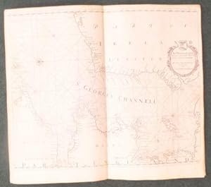
Ajouter au panierNo Binding. Etat : Very Good. MOXON J COLLINS J (illustrateur). WELSH Coast only. The First edition of the maps was in 1693, the first Sea Atlas produced by an Englishman and was reissued numerous times over the next hundred years. The maps in this offer make up 8 loose center fold charts of the Welsh Coast, not dated but c1750s, on thick heavy paper, 50*59 cms, no water marks, copper engravings, most showing a compass rose, rhumb lines, sailing boats, un-coloured, all with large decorative cartouches. They are: Not numbered - St Georges Channel, No 24 Milford-Haven, No 25 Milford Haven and the Islands Adjacent, 26 Cardigan Bay, 27 Holy-Head Part of the Island of Anglesey in North Wales, 28 P. of Carnarvan Shire, 29 The Isle of Man, 30 The River Dee or Chester-Water. All have a couple of tiny pin pricks to top left & right corners and a couple have a tiny pin prick to the maps -plotting?-. No date or edition stated. Housed in a large protective up and over box covered in brown book-cloth with printed title to front on white paper label. An interesting feature of Collins's maps are the series of straight lines originating in small black circles and ending at prominent landmarks on shore. The circles represent the position of the survey vessel, the locations of which were fixed by compass bearings represented by the straight lines. Soundings were taken by lead line and depths are indicated in fathoms. The survey took seven years and was undertaken from the Merlin, Monmouth, Martin, and the Younge Spragge. Collins probably used existing charts and seamen's sketches and notes, as well as his own observations in this remarkably ambitious undertaking. See ODNB for a full Bio. 0.
-

(P. of Carnarvan Shire/ P. of the Isle of Anglesey)
Edité par London, 1720
Vendeur : Clive A. Burden Ltd., Chalfont St. Giles, BUCKS, Royaume-Uni
Membre d'association : ABA ILAB
Évaluation du vendeur 5 sur 5 étoiles
Carte
EUR 178,45
Expédition ŕ EUR 25,58
Expédition depuis Royaume-Uni vers Etats-UnisQuantité disponible : 1 disponible(s)
Ajouter au panierNo binding. Etat : Good. 565 x 445 mm, on double backed paper as issued, in good condition. From the magnificent and important 'Great Britain's Coasting Pilot'. This was the first accurate sea survey domestically published. This fine chart displays the Menai Straits between the island of Anglesey and mainland Wales. Evans, Olwen Caradoc. (1969). 'Marine Plans and Charts of Wales', in Map Collectors' Circle no. 54; Verner 'Captain Collins' 'Coasting Pilot'', in Map Collectors' Circle no. 58; Shirley BL M.Coll 1a no. 19.
-

(Cardigan Bay)
Edité par London, 1693
Vendeur : Clive A. Burden Ltd., Chalfont St. Giles, BUCKS, Royaume-Uni
Membre d'association : ABA ILAB
Évaluation du vendeur 5 sur 5 étoiles
Carte
EUR 208,19
Expédition ŕ EUR 25,58
Expédition depuis Royaume-Uni vers Etats-UnisQuantité disponible : 1 disponible(s)
Ajouter au panierNo binding. Etat : Fair. 445 x 560 mm., with some support to the very edge of the margin on the right side, light water stain to the upper corners, a nice dark impression, otherwise in good condition. This chart of the west coast of Wales is from "The first systematic survey of British coastal waters and the first marine atlas of British waters engraved and printed in London from original surveys" (Verner). Since the late sixteenth century navigators in the waters of the British Isles had utilised the printed charts of the Dutch. During the mid-seventeenth century England fought three wars with the Dutch and her reliance on the work of the enemy was a clear source of embarrassment. The Dutch had private charts which were clearly superior to English sources.On 23 June 1681 Charles II commissioned Captain Greenvile Collins to make a survey of the coasts of Great Britain, a task undertaken between 1681 and 1688. Collins was an officer in the Royal Navy who from 1669 to 1671 had sailed with Sir John Narborough on his expedition to the Straits of Magellan and the Chilean coast. He was master of the frigate 'Charles' from 1676 to 1679 and served extensively in the Algerian war. He was promoted to Commander in 1679 and retained that rank until his death in 1694. The 'Coasting Pilot' is a remarkable surveying achievement, and a landmark in the charting of British coastal waters. NMM 335; Shirley 'Atlases in the British Library' M.Coll 1f; Verner 'Captain Collins' 'Coasting Pilot'', in Map Collectors' Circle no. 58 no. 15 state 3, all three states appear by 1693.
-

The Severn or Channell of Bristoll
Edité par London, 1693
Vendeur : Clive A. Burden Ltd., Chalfont St. Giles, BUCKS, Royaume-Uni
Membre d'association : ABA ILAB
Évaluation du vendeur 5 sur 5 étoiles
Carte
EUR 416,38
Expédition ŕ EUR 25,58
Expédition depuis Royaume-Uni vers Etats-UnisQuantité disponible : 1 disponible(s)
Ajouter au panierNo binding. Etat : Very Good. 435 x 505 mm., in recent wash colour, on thick paper and in good condition. This chart of the Bristol Channel is from "The first systematic survey of British coastal waters and the first marine atlas of British waters engraved and printed in London from original surveys" (Verner). The inset lower right illustrates the arrival of William III at Shirehampton on 6 September 1690 following the Battle of the Boyne. Since the late sixteenth century navigators in the waters of the British Isles had utilised the printed charts of the Dutch. During the mid-seventeenth century England fought three wars with the Dutch and her reliance on the work of the enemy was a clear source of embarrassment. The Dutch had private charts which were clearly superior to English sources.On 23 June 1681 Charles II commissioned Captain Greenvile Collins to make a survey of the coasts of Great Britain, a task undertaken between 1681 and 1688. Collins was an officer in the Royal Navy who from 1669 to 1671 had sailed with Sir John Narborough on his expedition to the Straits of Magellan and the Chilean coast. He was master of the frigate 'Charles' from 1676 to 1679 and served extensively in the Algerian war. He was promoted to Commander in 1679 and retained that rank until his death in 1694. The 'Coasting Pilot' is a remarkable surveying achievement, and a landmark in the charting of British coastal waters. This is an example of the first state. NMM 335; Shirley (2004) M.Coll 1a 14; Verner 'Captain Collins' 'Coasting Pilot'', in Map Collectors' Circle no. 58 no. 47.