
Montant total (1 article articles) :
Destination de la commande :

colton g w c b (240 résultats)
Commentaires
Passer aux résultats principaux de la recherche
Filtres de recherche
Type d'article
- Tous les types de produits
- Livres (232)
- Magazines & Périodiques (Aucun autre résultat ne correspond ŕ ces critčres)
- Bandes dessinées (Aucun autre résultat ne correspond ŕ ces critčres)
- Partitions de musique (Aucun autre résultat ne correspond ŕ ces critčres)
- Art, Affiches et Gravures (Aucun autre résultat ne correspond ŕ ces critčres)
- Photographies (Aucun autre résultat ne correspond ŕ ces critčres)
- Cartes (8)
- Manuscrits & Papiers anciens (Aucun autre résultat ne correspond ŕ ces critčres)
Etat En savoir plus
- Neuf (7)
- Comme neuf, Trčs bon ou Bon (12)
- Assez bon ou satisfaisant (15)
- Moyen ou mauvais (Aucun autre résultat ne correspond ŕ ces critčres)
- Conformément ŕ la description (206)
Particularités
- Ed. originale (13)
- Signé (Aucun autre résultat ne correspond ŕ ces critčres)
- Jaquette (1)
- Avec images (172)
- Sans impressions ŕ la demande (237)
Langue (3)
Livraison gratuite
- Livraison gratuite ŕ destination de France (Aucun autre résultat ne correspond ŕ ces critčres)
Pays
Evaluation du vendeur
-

A Manual to Accompany Colton's Missionary Map of the World Classic Reprint
Vendeur : PBShop.store US, Wood Dale, IL, Etats-Unis
Évaluation du vendeur 5 sur 5 étoiles

EUR 20,30
Autre deviseEUR 1,06 expédition depuis Etats-Unis vers FranceQuantité disponible : 15 disponible(s)
Ajouter au panierPAP. Etat : New. New Book. Shipped from UK. Established seller since 2000.
-
A Manual to Accompany Colton's Missionary Map of the World Classic Reprint
Vendeur : PBShop.store UK, Fairford, GLOS, Royaume-Uni
Évaluation du vendeur 5 sur 5 étoiles
EUR 18,48
Autre deviseEUR 4,88 expédition depuis Royaume-Uni vers FranceQuantité disponible : 15 disponible(s)
Ajouter au panierPAP. Etat : New. New Book. Shipped from UK. Established seller since 2000.
-

A Manual to Accompany Colton''s Missionary Map of the World (Classic Reprint)
Vendeur : PBShop.store US, Wood Dale, IL, Etats-Unis
Évaluation du vendeur 5 sur 5 étoiles
EUR 26,01
Autre deviseEUR 1,06 expédition depuis Etats-Unis vers FranceQuantité disponible : 15 disponible(s)
Ajouter au panierHRD. Etat : New. New Book. Shipped from UK. Established seller since 2000.
-
A Manual to Accompany Colton''s Missionary Map of the World (Classic Reprint)
Vendeur : PBShop.store UK, Fairford, GLOS, Royaume-Uni
Évaluation du vendeur 5 sur 5 étoiles
EUR 23,11
Autre deviseEUR 4,88 expédition depuis Royaume-Uni vers FranceQuantité disponible : 15 disponible(s)
Ajouter au panierHRD. Etat : New. New Book. Shipped from UK. Established seller since 2000.
-

Colton's New Sectional Map of the State of Missorui
Edité par VKM, Fort Worth, 1979
Vendeur : Young & Sons Enterprises, Apache, OK, Etats-Unis
Évaluation du vendeur 5 sur 5 étoiles
EUR 8,73
Autre deviseEUR 29,80 expédition depuis Etats-Unis vers FranceQuantité disponible : 1 disponible(s)
Ajouter au panierStapled Booklet. Etat : Very Good +. No Jacket. Facsimile. Reprint of the 1869 map. This is a very nice copy with minimal evidence of have been used. No names or writing within. NOT holepunched. Size: 4to - over 9ľ" - 12" tall.
-
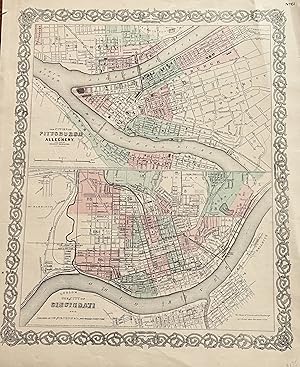
The Cities of Pittsburgh and Allegheny The City of CINCINNATI, OHIO with parts of adjacent boroughs, Pennsylvania:
Edité par Colton, J. H., New York, 1855
Vendeur : mediumraremaps.com, Franklin, TN, Etats-Unis
Évaluation du vendeur 4 sur 5 étoiles

Carte
EUR 35,08
Autre deviseEUR 7,66 expédition depuis Etats-Unis vers FranceQuantité disponible : 1 disponible(s)
Ajouter au panier12 1/2 X 15 3/4 INCHES. This map page has two maps. The upper map is of Pitts burgh and Allegheny. It is accopnyied by the lower half map of Cincinnati. Most important is the connection between the two cities; both were mated physically and economically by the Ohio River. These are very nice maps suitable for framing. it was hand colored in 1855 when the map was produced. Very good with a couple of repaired tears using archival mending tape.
-

A Manual to Accompany Colton's Missionary Map of the World (Classic Reprint)
Vendeur : Forgotten Books, London, Royaume-Uni
Évaluation du vendeur 5 sur 5 étoiles
EUR 16,16
Autre deviseEUR 11,45 expédition depuis Royaume-Uni vers FranceQuantité disponible : Plus de 20 disponibles
Ajouter au panierPaperback. Etat : New. Print on Demand. This book provides an overview of Christian missionary stations that were founded in various parts of the world during the 19th century. The stations were established by a range of different Christian denominations with the aim of spreading Christianity and providing social services such as education and healthcare to local communities. The author has carefully compiled a comprehensive list of these stations, including their locations, the denominations that founded them, and the dates they were established. This information is presented on a series of detailed maps that illustrate the global reach of Christian missionary activity during this period. The book also explores the complex history of Christian missions, discussing the motivations of the missionaries, the challenges they faced, and the impact their work had on both the local communities and the development of Christianity worldwide. Overall, this book serves as a valuable resource for anyone interested in the history of Christian missions and its global impact. This book is a reproduction of an important historical work, digitally reconstructed using state-of-the-art technology to preserve the original format. In rare cases, an imperfection in the original, such as a blemish or missing page, may be replicated in the book. print-on-demand item.
-

Colton's Vermont
Edité par New York, New York, 1870
Vendeur : High Ridge Books, Inc. - ABAA, South Deerfield, MA, Etats-Unis
Membre d'association : ABAA ESA ILAB SNEAB
Évaluation du vendeur 5 sur 5 étoiles
EUR 65,78
Autre deviseEUR 29,80 expédition depuis Etats-Unis vers FranceQuantité disponible : 1 disponible(s)
Ajouter au panier35x28.2 cm. Original cloth folder, front board detached. Fair condition overall. Repairs along several folds, small loss at two fold junctions in New York State. Full color by town. Inside front cover has a small contemporary bookseller's paste-down from Greenfield, Massachusetts. This is a folding version of the map of Vermont which appeared in Colton's General Atlas.
-
Colton's Map Of New Hampshire, Colored Pocket Map In Boards 1855 & 1864
Date d'édition : 1855
Langue: anglais
Vendeur : White Mountains, NH Books and Maps, Lincoln, NH, Etats-Unis
Évaluation du vendeur 4 sur 5 étoiles
EUR 123,75
Autre deviseEUR 34,06 expédition depuis Etats-Unis vers FranceQuantité disponible : 1 disponible(s)
Ajouter au panierHardcover. Etat : Near Fine. Measuring 13-1/2" X 15-3/4" Originally Folding Down To A 'Pocket-Size' 3-1/2" X 5". Ornate Edge Decorations, Borders And Counties Are Colored. A Nice Hand-Colored Map In Original Brown Cloth Boards (Near Fine With Light Nearly Imperceptible Wear) Gilt Titles. Note: Map Publication Date Is 1855 But Title Stamped 1864. Map Is Beautiful With Light Tanning In A Few Areas/Edges And 1 Corner Junction Split. Stamp In Upper Right Corner Of 'Ohio Historical And Philosophical Society' Small In Light Purple Ink. An Excellent Candidate For Framing And Display, Currently In Housed On 1/4" Archival Board And Clear Plastic Protective Bag.
-
Colton's New Hampshire, Colored Map 1874 Atlas
Langue: anglais
Vendeur : White Mountains, NH Books and Maps, Lincoln, NH, Etats-Unis
Évaluation du vendeur 4 sur 5 étoiles
EUR 55,48
Autre deviseEUR 34,06 expédition depuis Etats-Unis vers FranceQuantité disponible : 1 disponible(s)
Ajouter au panierNo Binding. Etat : Near Fine. Measuring 14-1/2"/W margins. Borders and counties are colored. No damage, very clean with a bit of tanning around edges, normal for this age paper.
-

Colton's Map of Africa; North Western Sheet.
Edité par G.W. & C.B. Colton & Co.,, New York:, 1866
Vendeur : Nicholas D. Riccio Rare Books, ABAA, Florham Park, NJ, Etats-Unis
Membre d'association : ABAA ILAB
Évaluation du vendeur 4 sur 5 étoiles
EUR 43,85
Autre deviseEUR 34,06 expédition depuis Etats-Unis vers FranceQuantité disponible : 1 disponible(s)
Ajouter au panierUnbound, colored engraved map, decorative boarder, 16"x 13". Slight toning and aging, some creasing and chipping at the edge of the left margin; overall bright and clean and in very good condition. Maps are wrapped with acid free board, or in rigid sleeves. Beginning with J. H. Colton (1800-1893), the Colton family published atlases for over 30 years. Colton's Atlas of the World was first published in 1855 in a large two volume set. In 1857 it became Colton's General Atlas, and Colton's sons, George Woolworth and Charles B. would take over the business. This map of the North Western portion of Africa is from the 1866 edition of Colton's General Atlas, even though the copyright date on the map is 1855. The map is fairly colorful with a fair amount of detail on Tropoli, Sudan and Guinea. Ristow 313-326.
-

Colton's Map of Africa; North Eastern Sheet.
Edité par G.W. & C.B. Colton & Co.,, New York:, 1866
Vendeur : Nicholas D. Riccio Rare Books, ABAA, Florham Park, NJ, Etats-Unis
Membre d'association : ABAA ILAB
Évaluation du vendeur 4 sur 5 étoiles
EUR 43,85
Autre deviseEUR 34,06 expédition depuis Etats-Unis vers FranceQuantité disponible : 1 disponible(s)
Ajouter au panierUnbound, colored engraved map, decorative boarder, 16"x 13". Slight toning and aging, a little light foxing in margin, some creasing and chipping at the edge of the left margin; overall bright and clean and in very good condition. Maps are wrapped with acid free board, or in rigid sleeves. Beginning with J. H. Colton (1800-1893), the Colton family published atlases for over 30 years. Colton's Atlas of the World was first published in 1855 in a large two volume set. In 1857 it became Colton's General Atlas, and Colton's sons, George Woolworth and Charles B. would take over the business. This map of the North Western portion of Africa is from the 1866 edition of Colton's General Atlas, even though the copyright date on the map is 1855. The map is fairly colorful with a decorative border and shows part of Arabia, Nubia and an inset shows the Nile Delta. Ristow 313-326.
-
Colton's Map of Connecticut (Folding Pocket map) 1869.
Langue: anglais
Vendeur : White Mountains, NH Books and Maps, Lincoln, NH, Etats-Unis
Évaluation du vendeur 4 sur 5 étoiles
EUR 64,01
Autre deviseEUR 34,06 expédition depuis Etats-Unis vers FranceQuantité disponible : 1 disponible(s)
Ajouter au panierNo Binding. Etat : Near Fine. A nice example with hand-colored map folded into dark brown blind-stamped stiff bds. VG+ condition, bds are quite rough with wear, poor.
-
Map of the State of New York Accompanying the legislative Manual 1878. [Being] Colton's Railroad & Township Map of the State of New YorkWith Parts of the Adjoining States and Canada
Edité par Weed, parsons & Co. [map: Published by G. W. & C. B. Colton & Co], New York, 1878
Vendeur : The Old Mill Bookshop, HACKETTSTOWN, NJ, Etats-Unis
Évaluation du vendeur 2 sur 5 étoiles

EUR 131,56
Autre deviseEUR 38,32 expédition depuis Etats-Unis vers FranceQuantité disponible : 1 disponible(s)
Ajouter au panierLarge folding handcolored map (28 x 25 inches), engraved by J. M. Atwood after George W. Colton. Elaborate uncolored ornamental border, counties outlined and handcolored, statistics printed in upper corner, tear from stub about 2 inches into map. 1 vols. 8vo case. Red morocco patterned boards, printed in gilt. Insect damage to spine penetrating to pastedowns, rubbed, some discoloration or soiling of boards, else very good Large folding handcolored map (28 x 25 inches), engraved by J. M. Atwood after George W. Colton. Elaborate uncolored ornamental border, counties outlined and handcolored, statistics printed in upper corner, tear from stub about 2 inches into map. 1 vols. 8vo case.
-

Colton's Massachusetts, Connecticut and Rhode Island
Edité par Colton, G. W. & C. B., New York, 1866
Vendeur : mediumraremaps.com, Franklin, TN, Etats-Unis
Évaluation du vendeur 4 sur 5 étoiles
Carte
EUR 74,55
Autre deviseEUR 7,66 expédition depuis Etats-Unis vers FranceQuantité disponible : 1 disponible(s)
Ajouter au panier26 x 17 inches. Large two page map of MA, CT and RI. Finely colored throughout with three color county differential coloring scheme. Good with multiple tears expertly repaired with archival mending tape.
-
Map of the Richmond and Louisville Railroad, Connecting the Railroads of Virginia with the Railroads of Kentucky on the Shortest Route East and West from the Mississippi Valley to the Atlantic Ocean
Edité par Colton & Co, N.Y., 1882
Vendeur : Recycled, Corte Madera, CA, Etats-Unis
Évaluation du vendeur 5 sur 5 étoiles
Carte Edition originale
EUR 153,49
Autre deviseEUR 25,55 expédition depuis Etats-Unis vers FranceQuantité disponible : 1 disponible(s)
Ajouter au panierSoft cover. Etat : Very Good. Illustrated (illustrateur). 1st Edition. Lithographed map, folded into stiff tan card wrappers with the title on the cover, which is tanned and chipped. The map itself is 48 x 25.5 inches, but the wrappers only 5 by 10 inches, so there are fold lines, a few tears at those lines, and minor edge chipping to the map.
-
MAP SHOWING THE BURLINGTON, CEDAR RAPIDS AND MINNESOTA RAILWAY And Its Connections
Edité par G.W. & C.B. Colton: NY, 1868
Vendeur : John K King Used & Rare Books, Detroit, MI, Etats-Unis
Évaluation du vendeur 5 sur 5 étoiles
EUR 151,30
Autre deviseEUR 29,80 expédition depuis Etats-Unis vers FranceQuantité disponible : 1 disponible(s)
Ajouter au panierPaperback. Etat : Good. 34 x 25", colored map, folds, edges chipped, creased and unevenly cut, toning at folds, horizontal center fold torn halfway through from left edge, but still an interesting map showing the Mississippi Valley from Minnesota down to southern Missouri. SWAF. Not a reprint!
-
Colton's Map of Kentucky
Edité par G.W. & C.B. Colton & Co.
Vendeur : Wonder Book, Frederick, MD, Etats-Unis
Membre d'association : ABAA ILAB
Évaluation du vendeur 5 sur 5 étoiles
EUR 173,65
Autre deviseEUR 21,29 expédition depuis Etats-Unis vers FranceQuantité disponible : 1 disponible(s)
Ajouter au panierEtat : Good. New York: G.W. & C.B. Colton, 1865. 24mo decoratively embossed cloth hardcover with gilt lettering to the front. Pubisher information on front pastedown. 29 x 56 cm Fold-out map of Kentucky with portions of adjoining states represented. State borders outlined in pink, counties shaded differing colors, with relief shown by hachures. Good condition. Near Fine cover is in remarkable condition. Front endpaper shows a small brown fleck. Brown ink "x"s marked though the center of the map, else Very Good to Near Fine. (Kentucky, Map) Inquire if you need further information.
-

Colton's Township Map of the State of New Jersey
Edité par G.W. & C.B. Colton & Co., 1880
Vendeur : Crooked House Books & Paper, CBA, ABAA, Portland, OR, Etats-Unis
Membre d'association : ABAA CBA ESA ILAB
Évaluation du vendeur 4 sur 5 étoiles
EUR 175,42
Autre deviseEUR 30,66 expédition depuis Etats-Unis vers FranceQuantité disponible : 1 disponible(s)
Ajouter au panierHardcover. Etat : Very Good. Hardcover boards with blindstamped decorative frames, and gilt lettering to front board, color map folded within. Some splitting to endpapers at internal hinge, map itself is bright & clean with no tears. A lovely example, priced low because we're on the wrong coast!
-

Colton's Dominion of Canada, No. 3. The Provinces of New Brunswick, Nova Scotia and Prince Edward Island
Edité par New York. Published by G.W. & C.B. Colton. 1880, 1880
Vendeur : J. Patrick McGahern Books Inc. (ABAC), Ottawa, ON, Canada
Membre d'association : ABAC ILAB IOBA
Évaluation du vendeur 3 sur 5 étoiles

EUR 220,91
Autre deviseEUR 16,18 expédition depuis Canada vers FranceQuantité disponible : 1 disponible(s)
Ajouter au panierHardcover. folding map on thin rice paper, 46x 67cm, (18"x 26.5"), hand coloured in outline, in the original blind decorated grey cloth, gilt titles on the upper cover, in mint condition, scarce. (n12) Newfoundland replaces Prince Edward Island on the upper cover title.
-

Colton's New Township Map of the Eastern Counties of Pennsylvania
Edité par New York, New York, 1890
Vendeur : High Ridge Books, Inc. - ABAA, South Deerfield, MA, Etats-Unis
Membre d'association : ABAA ESA ILAB SNEAB
Évaluation du vendeur 5 sur 5 étoiles
EUR 263,13
Autre deviseEUR 29,80 expédition depuis Etats-Unis vers FranceQuantité disponible : 1 disponible(s)
Ajouter au panierOriginal cloth folder. Linen-backed but not dissected. fine condition. A late Colton issue of a map first published in 1865. Full color by town. Pastedown slip for J. L. Smith, map publisher in Philadelphia. Shows the eastern part of the state, to just past the Susquehanna River.
-

Colton's Railroad & Township Map of the State of New York, with Parts of the Adjoining States and Canada
Edité par New York, New York, 1892
Vendeur : High Ridge Books, Inc. - ABAA, South Deerfield, MA, Etats-Unis
Membre d'association : ABAA ESA ILAB SNEAB
Évaluation du vendeur 5 sur 5 étoiles
EUR 285,05
Autre deviseEUR 29,80 expédition depuis Etats-Unis vers FranceQuantité disponible : 1 disponible(s)
Ajouter au panierOriginal cloth, lightly stained, map is fine. This is among the latest publications of the once-great Colton mapmaking company. By the 1890's, the firm was primarily producing maps of interest in the New York City area, including maps of the city, state,
-
Colton's Map of Connecticut.
Edité par G.W. & C. B. Colton,, New York:, 1870
Vendeur : Nicholas D. Riccio Rare Books, ABAA, Florham Park, NJ, Etats-Unis
Membre d'association : ABAA ILAB
Évaluation du vendeur 4 sur 5 étoiles
EUR 285,05
Autre deviseEUR 34,06 expédition depuis Etats-Unis vers FranceQuantité disponible : 1 disponible(s)
Ajouter au panierFolding map, original gilt lettered cloth, colored 13 1/2x11 1/2. Top cover almost detached, a little additional wear and staining to binding, several small brown spots on the map; however, the map is fairly clean and sturdy otherwise. The Colton family has been producing high quality folding maps since 1833. Following in the footsteps of their father, J.H. Colton, this is the work of his sons. The map is a very nice state map, and has the Colton trademark decorative boarder.
-

Colton's Railroad & Township Map of the State of New York with Parts of the Adjoining States & Canada
Edité par New York, New York, 1884
Vendeur : High Ridge Books, Inc. - ABAA, South Deerfield, MA, Etats-Unis
Membre d'association : ABAA ESA ILAB SNEAB
Évaluation du vendeur 5 sur 5 étoiles
EUR 306,98
Autre deviseEUR 29,80 expédition depuis Etats-Unis vers FranceQuantité disponible : 1 disponible(s)
Ajouter au panierOriginal cloth, fine condition with manuscript circles drawn around some city names. Full color by town. Includes most of Pennsylvania, extending to Pittsburgh which is in the border at the lower left. This is a late reissue of the basic Colton New York State map which had first been issued in 1852. There are a huge number of changes from that first map, though the basic land features and town boundaries have been retained intact.
-
Colton's Kentucky. Cover title: Colton's Map of Kentucky.
Edité par G. W. & C. B. Colton, New York, 1869
Vendeur : Jeffrey H. Marks, Rare Books, ABAA, Rochester, NY, Etats-Unis
Membre d'association : ABAA ILAB
Évaluation du vendeur 5 sur 5 étoiles
EUR 306,98
Autre deviseEUR 30,66 expédition depuis Etats-Unis vers FranceQuantité disponible : 1 disponible(s)
Ajouter au panierColored map; publisher's printed ads on pastedown. Image approx. 14 x 22 inches, folded to 12mo, publisher's gilt-lettered brown embossed cloth portfolio as issued. A few light brown stains to a small area; otherwise a fine, crisp example.
-
COLTON'S NEW TOWNSHIP MAP OF THE STATE OF CONNECTICUT.
Edité par New York, 1883
Vendeur : Steve Finer - Rare Books, Greenfield, MA, Etats-Unis
Membre d'association : SNEAB
Évaluation du vendeur 5 sur 5 étoiles
Carte Edition originale
EUR 306,98
Autre deviseEUR 35,81 expédition depuis Etats-Unis vers FranceQuantité disponible : 1 disponible(s)
Ajouter au panierHardcover. Etat : Very Good. No Jacket. 1st Edition. 16mo, original gilt stamped cloth folder, containing fully colored map in pinks and greens, approx. 25" x 18.25," a few inevitable breaks at folds, with publisher's promotional text leaf mounted to inside front cover. A Very Good copy.
-

Colton's Map of Europe
Edité par New York, New York, 1881
Vendeur : High Ridge Books, Inc. - ABAA, South Deerfield, MA, Etats-Unis
Membre d'association : ABAA ESA ILAB SNEAB
Évaluation du vendeur 5 sur 5 étoiles
EUR 328,91
Autre deviseEUR 29,80 expédition depuis Etats-Unis vers FranceQuantité disponible : 1 disponible(s)
Ajouter au panierLarge map with decorative border in original cloth folder. fine condition, with only small tears along one fold and at some fold junctions. Shows the whole continent as far as the Caspian Sea. Bright full color by country. This map was only issued separately, never having been issued in any of Colton's atlases.
-

Colton's New Township Map of the Eastern Counties of Pennsylvania
Edité par New York, New York, 1866
Vendeur : High Ridge Books, Inc. - ABAA, South Deerfield, MA, Etats-Unis
Membre d'association : ABAA ESA ILAB SNEAB
Évaluation du vendeur 5 sur 5 étoiles
EUR 350,84
Autre deviseEUR 29,80 expédition depuis Etats-Unis vers FranceQuantité disponible : 1 disponible(s)
Ajouter au panierOriginal cloth folder. Very good condition, minor separations at fold junctions. Shows the eastern part of the state, to just past the Susquehanna River.
-
sold - Colton's west imdies
Edité par Colton & Co., New York, 1886
Vendeur : Bibliophilia Books, Tampa, FL, Etats-Unis
Évaluation du vendeur 5 sur 5 étoiles
EUR 328,91
Autre deviseEUR 55,35 expédition depuis Etats-Unis vers FranceQuantité disponible : 1 disponible(s)
Ajouter au panierHardcover. Etat : Near Fine. (12x8.5 cm) 12mo. - Color map, 310x440 mm, folded to150x110 mm. - Scale:150 miles to the inch. -- Embossed cloth; title embossed in gilt. - With 2 color inset maps [Bermuda and Havana]. - Fine; interior very fine.
-

Township Map of the State of Maine with Adjoining Portions of Canada & New Brunswick
Edité par New York, New York, 1884
Vendeur : High Ridge Books, Inc. - ABAA, South Deerfield, MA, Etats-Unis
Membre d'association : ABAA ESA ILAB SNEAB
Évaluation du vendeur 5 sur 5 étoiles
EUR 394,69
Autre deviseEUR 29,80 expédition depuis Etats-Unis vers FranceQuantité disponible : 1 disponible(s)
Ajouter au panier91x72 cm. Folding map in original gilt-stamped folder. Good to very good condition, with several mends along one horizontal fold, separations at some fold junctions with minor chipping loss along one fold. Full color by town. This is a large separately published map of the state, not a pocket map version of an atlas map. This map was only published as a pocket (or possibly wall) map, not included in any atlas. Unusual for Colton maps, there is no copyright date. A rare, large map of Maine, among the later maps published by the Colton company.


