
Montant total (1 article articles) :
Destination de la commande :

geographia map company (Plus de 1 000 résultats)
Commentaires
Passer aux résultats principaux de la recherche
Filtres de recherche
Type d'article
- Tous les types de produits
- Livres (192)
- Magazines & Périodiques (Aucun autre résultat ne correspond ŕ ces critčres)
- Bandes dessinées (Aucun autre résultat ne correspond ŕ ces critčres)
- Partitions de musique (Aucun autre résultat ne correspond ŕ ces critčres)
- Art, Affiches et Gravures (Aucun autre résultat ne correspond ŕ ces critčres)
- Photographies (Aucun autre résultat ne correspond ŕ ces critčres)
- Cartes (817)
- Manuscrits & Papiers anciens (Aucun autre résultat ne correspond ŕ ces critčres)
Etat En savoir plus
Particularités
- Ed. originale (Aucun autre résultat ne correspond ŕ ces critčres)
- Signé (Aucun autre résultat ne correspond ŕ ces critčres)
- Jaquette (Aucun autre résultat ne correspond ŕ ces critčres)
- Avec images (993)
- Sans impressions ŕ la demande (1 007)
Langue (2)
Livraison gratuite
Pays
Evaluation du vendeur
-

Geographia QuikFinder Manhattan New York Map
Vendeur : HPB-Emerald, Dallas, TX, Etats-Unis
Évaluation du vendeur 5 sur 5 étoiles

EUR 3,49
Autre deviseEUR 3,19 expédition vers Etats-UnisQuantité disponible : 1 disponible(s)
Ajouter au panierpamphlet. Etat : Very Good. Connecting readers with great books since 1972! Used books may not include companion materials, and may have some shelf wear or limited writing. We ship orders daily and Customer Service is our top priority!
-

Geographia Ireland road atlas
Vendeur : Better World Books: West, Reno, NV, Etats-Unis
Évaluation du vendeur 5 sur 5 étoiles
EUR 13,12
Autre deviseGratuit expédition vers Etats-UnisQuantité disponible : 1 disponible(s)
Ajouter au panierEtat : Good. Former library book; may include library markings. Used book that is in clean, average condition without any missing pages.
Plus de choix d'achat de la part d'autres vendeurs sur AbeBooks
Offres d'occasion ŕ partir de EUR 13,12
Trouvez également Couverture souple
-

Geographia's five borough pocket atlas of New York City
Vendeur : HPB-Diamond, Dallas, TX, Etats-Unis
Évaluation du vendeur 5 sur 5 étoiles
EUR 11,34
Autre deviseEUR 3,19 expédition vers Etats-UnisQuantité disponible : 1 disponible(s)
Ajouter au panierhardcover. Etat : Very Good. Connecting readers with great books since 1972! Used books may not include companion materials, and may have some shelf wear or limited writing. We ship orders daily and Customer Service is our top priority!
Plus de choix d'achat de la part d'autres vendeurs sur AbeBooks
Offres d'occasion ŕ partir de EUR 14,53
Trouvez également Couverture rigide Couverture souple
-

Geographia QuikFinder: New York City - Manhattan
Vendeur : Wonder Book, Frederick, MD, Etats-Unis
Membre d'association : ABAA ILAB
Évaluation du vendeur 5 sur 5 étoiles
EUR 10,92
Autre deviseGratuit expédition vers Etats-UnisQuantité disponible : 1 disponible(s)
Ajouter au panierEtat : Very Good. Very Good condition. (map, new york, manhattan) A copy that may have a few cosmetic defects. May also contain a few markings such as an owner's name, short gifter's inscription or light stamp.
-

Geographia Westchester/Putnam Counties Streetatlas
Vendeur : Rob the Book Man, Vancouver, WA, Etats-Unis
Évaluation du vendeur 4 sur 5 étoiles

EUR 17,29
Autre deviseEUR 5,94 expédition vers Etats-UnisQuantité disponible : 1 disponible(s)
Ajouter au panierSoft cover. Etat : Good. Large spiral paperback in good condition.
-

Westchester; Putnam counties street atlas
Edité par Geographia Map Co., Weehawken, N.J., 1995
Vendeur : CorgiPack, Fulton, NY, Etats-Unis
Évaluation du vendeur 4 sur 5 étoiles
EUR 17,47
Autre deviseGratuit expédition vers Etats-UnisQuantité disponible : 1 disponible(s)
Ajouter au panierWire spiral bound. Etat : Good. Special Laminated edition. Wear to covers. Text free of highlighting and writing. Revised edition of: Geographia's street atlas of Westchester and Putnam counties, New York. 4th ed. 1987 Includes zip code and highway maps, handy community listing and indexes.
-

Geographia New York City 5 Borough Streetatlas Pathfinder Edition
Edité par Geographia Map Company
Vendeur : Wonder Book, Frederick, MD, Etats-Unis
Membre d'association : ABAA ILAB
Évaluation du vendeur 5 sur 5 étoiles
EUR 19,23
Autre deviseGratuit expédition vers Etats-UnisQuantité disponible : 1 disponible(s)
Ajouter au panierEtat : Good. Good condition. Pathfinder Edition. Large Print edition. ISBN 0884332594. (new york, street map, city map) A copy that has been read but remains intact. May contain markings such as bookplates, stamps, limited notes and highlighting, or a few light stains.
-

Barnet, Bentley Heath, Dancers Hill, Ganwick Corner, Kitt's End, Monken Hadley
Date d'édition : 1937
Vendeur : Antiqua Print Gallery, London, Royaume-Uni
Évaluation du vendeur 3 sur 5 étoiles

Carte
EUR 4,76
Autre deviseEUR 11,56 expédition depuis Royaume-Uni vers Etats-UnisQuantité disponible : 14 disponible(s)
Ajouter au panierEtat : Good. BARNET. Monken Hadley Wrotham Park Kitts End Dancer's Hill Ganwick Cnr 1937 map. Colour vintage street atlas map; The Geographia map company (1937). 30.5 x 18.5cm, 12 x 7.25 inches. Condition: Good. There is another map printed on the reverse side of this map. The paper is thick, and the map on the reverse side does not show through the paper. Map section #3 This map is one section from a 1937 Street Atlas of Greater London. This section of the map depicts the following suburbs in 1937: Barnet,Bentley Heath,Dancers Hill,Ganwick Corner,Kitt's End,Monken Hadley The maps in this series show London during the rapid interwar suburban expansion. Many areas shown in the outer suburbs as undeveloped land on these maps are now built up. Less frequently, some maps indicate housing developments proposed in 1937 but which were never built on land which is still undeveloped, or which has been built up according to a different street layout from that shown. The inner London maps in this series show London before the damage inflicted by the Blitz during World War 2 and the subsequent redevelopment of the 1950's and 1960's. These maps predate the construction of any motorways (the M1 sections into London having opened between 1966-1977), many major roads, and other post-war urban traffic schemes. The elevated sections of many major roads were constructed after the second world war; for example, the maps predate the construction of the Westway and elevated sections of the A4; the Western Avenue is shown on map sections #142 & #143 as proposed or under construction to the west of Northolt Aerodrome. The London docklands are shown at the height of their scale and glory, a network of large docks and railway lines. The last dock to be built had been completed in 1921. The prosperity of the docklands continued until the advent of containerisation 1960's, whereafter they remained derelict until redevelopment commenced in the early 1980's, centred around the area now known as Canary Wharf These maps show a number of now disappeared features, such as aerodromes which have since disappeared or changed their use, the Brooklands motor racing circuit (shown on map section #157, 2 years before it hosted its last race in 1939), and railways which are now disused. LHR is shown on map section #150 as the modest "Great West Aerodrome"; the original Heathrow Hall is also depicted on this map. The airport at that time was used for aircraft assembly and testing, with Croydon Airport (shown on map sections #163 and #164) being the main airport used for commercial flights.
-
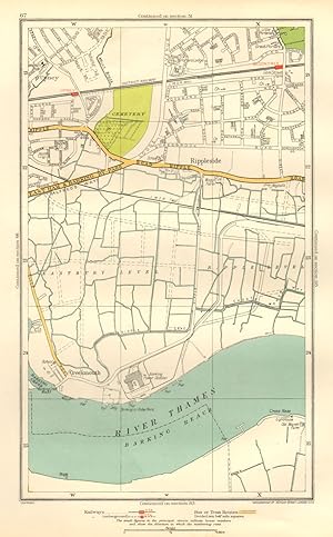
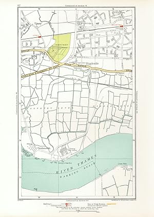
Creekmouth, Rippleside, Upney
Date d'édition : 1937
Vendeur : Antiqua Print Gallery, London, Royaume-Uni
Évaluation du vendeur 3 sur 5 étoiles
Carte
EUR 4,76
Autre deviseEUR 11,56 expédition depuis Royaume-Uni vers Etats-UnisQuantité disponible : 7 disponible(s)
Ajouter au panierEtat : Good. LONDON. Creekmouth Rippleside Upney Becontree Thamesmead 1937 old vintage map. Colour vintage street atlas map; The Geographia map company (1937). 30.5 x 18.5cm, 12 x 7.25 inches. Condition: Good. There is another map printed on the reverse side of this map. The paper is thick, and the map on the reverse side does not show through the paper. Map section #67 This map is one section from a 1937 Street Atlas of Greater London. This section of the map depicts the following suburbs in 1937: Creekmouth,Rippleside,Upney The maps in this series show London during the rapid interwar suburban expansion. Many areas shown in the outer suburbs as undeveloped land on these maps are now built up. Less frequently, some maps indicate housing developments proposed in 1937 but which were never built on land which is still undeveloped, or which has been built up according to a different street layout from that shown. The inner London maps in this series show London before the damage inflicted by the Blitz during World War 2 and the subsequent redevelopment of the 1950's and 1960's. These maps predate the construction of any motorways (the M1 sections into London having opened between 1966-1977), many major roads, and other post-war urban traffic schemes. The elevated sections of many major roads were constructed after the second world war; for example, the maps predate the construction of the Westway and elevated sections of the A4; the Western Avenue is shown on map sections #142 & #143 as proposed or under construction to the west of Northolt Aerodrome. The London docklands are shown at the height of their scale and glory, a network of large docks and railway lines. The last dock to be built had been completed in 1921. The prosperity of the docklands continued until the advent of containerisation 1960's, whereafter they remained derelict until redevelopment commenced in the early 1980's, centred around the area now known as Canary Wharf These maps show a number of now disappeared features, such as aerodromes which have since disappeared or changed their use, the Brooklands motor racing circuit (shown on map section #157, 2 years before it hosted its last race in 1939), and railways which are now disused. LHR is shown on map section #150 as the modest "Great West Aerodrome"; the original Heathrow Hall is also depicted on this map. The airport at that time was used for aircraft assembly and testing, with Croydon Airport (shown on map sections #163 and #164) being the main airport used for commercial flights.
-
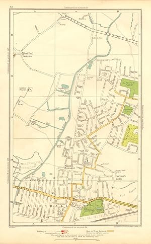
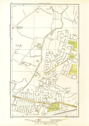
Dormer's Wells, Mount Pleasant , Southall, West End, Middlesex
Date d'édition : 1937
Vendeur : Antiqua Print Gallery, London, Royaume-Uni
Évaluation du vendeur 3 sur 5 étoiles
Carte
EUR 4,76
Autre deviseEUR 11,56 expédition depuis Royaume-Uni vers Etats-UnisQuantité disponible : 7 disponible(s)
Ajouter au panierEtat : Good. MIDDLESEX. Dormer's Wells Mount Pleasant Southall West End 1937 old map. Colour vintage street atlas map; The Geographia map company (1937). 30.5 x 18.5cm, 12 x 7.25 inches. Condition: Good. There is another map printed on the reverse side of this map. The paper is thick, and the map on the reverse side does not show through the paper. Map section #53 This map is one section from a 1937 Street Atlas of Greater London. This section of the map depicts the following suburbs in 1937: Dormer's Wells,Mount Pleasant ,Southall,West End, Middlesex The maps in this series show London during the rapid interwar suburban expansion. Many areas shown in the outer suburbs as undeveloped land on these maps are now built up. Less frequently, some maps indicate housing developments proposed in 1937 but which were never built on land which is still undeveloped, or which has been built up according to a different street layout from that shown. The inner London maps in this series show London before the damage inflicted by the Blitz during World War 2 and the subsequent redevelopment of the 1950's and 1960's. These maps predate the construction of any motorways (the M1 sections into London having opened between 1966-1977), many major roads, and other post-war urban traffic schemes. The elevated sections of many major roads were constructed after the second world war; for example, the maps predate the construction of the Westway and elevated sections of the A4; the Western Avenue is shown on map sections #142 & #143 as proposed or under construction to the west of Northolt Aerodrome. The London docklands are shown at the height of their scale and glory, a network of large docks and railway lines. The last dock to be built had been completed in 1921. The prosperity of the docklands continued until the advent of containerisation 1960's, whereafter they remained derelict until redevelopment commenced in the early 1980's, centred around the area now known as Canary Wharf These maps show a number of now disappeared features, such as aerodromes which have since disappeared or changed their use, the Brooklands motor racing circuit (shown on map section #157, 2 years before it hosted its last race in 1939), and railways which are now disused. LHR is shown on map section #150 as the modest "Great West Aerodrome"; the original Heathrow Hall is also depicted on this map. The airport at that time was used for aircraft assembly and testing, with Croydon Airport (shown on map sections #163 and #164) being the main airport used for commercial flights.
-
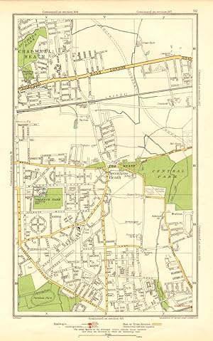
Chadwell Heath
Date d'édition : 1937
Vendeur : Antiqua Print Gallery, London, Royaume-Uni
Évaluation du vendeur 3 sur 5 étoiles
Carte
EUR 4,76
Autre deviseEUR 11,56 expédition depuis Royaume-Uni vers Etats-UnisQuantité disponible : 7 disponible(s)
Ajouter au panierEtat : Good. ROMFORD. Chadwell Heath Becontree Dagenham Valence Park 1937 old vintage map. Colour vintage street atlas map; The Geographia map company (1937). 30.5 x 18.5cm, 12 x 7.25 inches. Condition: Good. There is another map printed on the reverse side of this map. The paper is thick, and the map on the reverse side does not show through the paper. Map section #52 This map is one section from a 1937 Street Atlas of Greater London. This section of the map depicts the following suburbs in 1937: Chadwell Heath The maps in this series show London during the rapid interwar suburban expansion. Many areas shown in the outer suburbs as undeveloped land on these maps are now built up. Less frequently, some maps indicate housing developments proposed in 1937 but which were never built on land which is still undeveloped, or which has been built up according to a different street layout from that shown. The inner London maps in this series show London before the damage inflicted by the Blitz during World War 2 and the subsequent redevelopment of the 1950's and 1960's. These maps predate the construction of any motorways (the M1 sections into London having opened between 1966-1977), many major roads, and other post-war urban traffic schemes. The elevated sections of many major roads were constructed after the second world war; for example, the maps predate the construction of the Westway and elevated sections of the A4; the Western Avenue is shown on map sections #142 & #143 as proposed or under construction to the west of Northolt Aerodrome. The London docklands are shown at the height of their scale and glory, a network of large docks and railway lines. The last dock to be built had been completed in 1921. The prosperity of the docklands continued until the advent of containerisation 1960's, whereafter they remained derelict until redevelopment commenced in the early 1980's, centred around the area now known as Canary Wharf These maps show a number of now disappeared features, such as aerodromes which have since disappeared or changed their use, the Brooklands motor racing circuit (shown on map section #157, 2 years before it hosted its last race in 1939), and railways which are now disused. LHR is shown on map section #150 as the modest "Great West Aerodrome"; the original Heathrow Hall is also depicted on this map. The airport at that time was used for aircraft assembly and testing, with Croydon Airport (shown on map sections #163 and #164) being the main airport used for commercial flights.
-
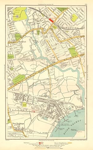
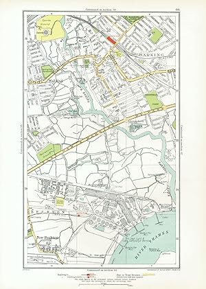
Barking, Beckton, Cyprus, New Beckton , Wall End
Date d'édition : 1937
Vendeur : Antiqua Print Gallery, London, Royaume-Uni
Évaluation du vendeur 3 sur 5 étoiles
Carte
EUR 4,76
Autre deviseEUR 11,56 expédition depuis Royaume-Uni vers Etats-UnisQuantité disponible : 6 disponible(s)
Ajouter au panierEtat : Good. LONDON. Barking Beckton Cyprus New Beckton Wall End 1937 old vintage map chart. Colour vintage street atlas map; The Geographia map company (1937). 30.5 x 18.5cm, 12 x 7.25 inches. Condition: Good. There is another map printed on the reverse side of this map. The paper is thick, and the map on the reverse side does not show through the paper. Map section #66 This map is one section from a 1937 Street Atlas of Greater London. This section of the map depicts the following suburbs in 1937: Barking,Beckton,Cyprus,New Beckton ,Wall End The maps in this series show London during the rapid interwar suburban expansion. Many areas shown in the outer suburbs as undeveloped land on these maps are now built up. Less frequently, some maps indicate housing developments proposed in 1937 but which were never built on land which is still undeveloped, or which has been built up according to a different street layout from that shown. The inner London maps in this series show London before the damage inflicted by the Blitz during World War 2 and the subsequent redevelopment of the 1950's and 1960's. These maps predate the construction of any motorways (the M1 sections into London having opened between 1966-1977), many major roads, and other post-war urban traffic schemes. The elevated sections of many major roads were constructed after the second world war; for example, the maps predate the construction of the Westway and elevated sections of the A4; the Western Avenue is shown on map sections #142 & #143 as proposed or under construction to the west of Northolt Aerodrome. The London docklands are shown at the height of their scale and glory, a network of large docks and railway lines. The last dock to be built had been completed in 1921. The prosperity of the docklands continued until the advent of containerisation 1960's, whereafter they remained derelict until redevelopment commenced in the early 1980's, centred around the area now known as Canary Wharf These maps show a number of now disappeared features, such as aerodromes which have since disappeared or changed their use, the Brooklands motor racing circuit (shown on map section #157, 2 years before it hosted its last race in 1939), and railways which are now disused. LHR is shown on map section #150 as the modest "Great West Aerodrome"; the original Heathrow Hall is also depicted on this map. The airport at that time was used for aircraft assembly and testing, with Croydon Airport (shown on map sections #163 and #164) being the main airport used for commercial flights.
-
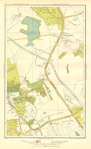
Elstree, Stanmore
Date d'édition : 1937
Vendeur : Antiqua Print Gallery, London, Royaume-Uni
Évaluation du vendeur 3 sur 5 étoiles
Carte
EUR 4,76
Autre deviseEUR 11,56 expédition depuis Royaume-Uni vers Etats-UnisQuantité disponible : 8 disponible(s)
Ajouter au panierEtat : Good. HERTS. Elstree Stanmore Edgware Aldenham Park Canons Park 1937 old vintage map. Colour vintage street atlas map; The Geographia map company (1937). 30.5 x 18.5cm, 12 x 7.25 inches. Condition: Good. There is another map printed on the reverse side of this map. The paper is thick, and the map on the reverse side does not show through the paper. Map section #11 This map is one section from a 1937 Street Atlas of Greater London. This section of the map depicts the following suburbs in 1937: Elstree,Stanmore The maps in this series show London during the rapid interwar suburban expansion. Many areas shown in the outer suburbs as undeveloped land on these maps are now built up. Less frequently, some maps indicate housing developments proposed in 1937 but which were never built on land which is still undeveloped, or which has been built up according to a different street layout from that shown. The inner London maps in this series show London before the damage inflicted by the Blitz during World War 2 and the subsequent redevelopment of the 1950's and 1960's. These maps predate the construction of any motorways (the M1 sections into London having opened between 1966-1977), many major roads, and other post-war urban traffic schemes. The elevated sections of many major roads were constructed after the second world war; for example, the maps predate the construction of the Westway and elevated sections of the A4; the Western Avenue is shown on map sections #142 & #143 as proposed or under construction to the west of Northolt Aerodrome. The London docklands are shown at the height of their scale and glory, a network of large docks and railway lines. The last dock to be built had been completed in 1921. The prosperity of the docklands continued until the advent of containerisation 1960's, whereafter they remained derelict until redevelopment commenced in the early 1980's, centred around the area now known as Canary Wharf These maps show a number of now disappeared features, such as aerodromes which have since disappeared or changed their use, the Brooklands motor racing circuit (shown on map section #157, 2 years before it hosted its last race in 1939), and railways which are now disused. LHR is shown on map section #150 as the modest "Great West Aerodrome"; the original Heathrow Hall is also depicted on this map. The airport at that time was used for aircraft assembly and testing, with Croydon Airport (shown on map sections #163 and #164) being the main airport used for commercial flights.
-
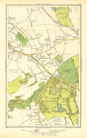
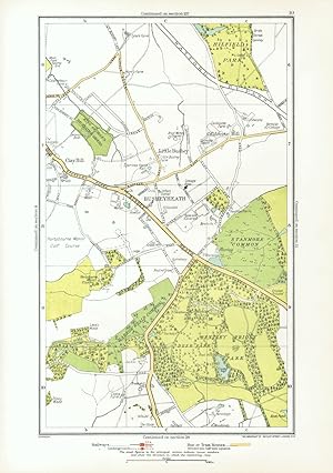
Busheyheath, Caldecote Hill, Clay Hill, Little Bushey
Date d'édition : 1937
Vendeur : Antiqua Print Gallery, London, Royaume-Uni
Évaluation du vendeur 3 sur 5 étoiles
Carte
EUR 4,76
Autre deviseEUR 11,56 expédition depuis Royaume-Uni vers Etats-UnisQuantité disponible : 8 disponible(s)
Ajouter au panierEtat : Good. HERTS. Busheyheath Caldecote Hill Clay Hill Little Bushey Stanmore Cmn 1937 map. Colour vintage street atlas map; The Geographia map company (1937). 30.5 x 18.5cm, 12 x 7.25 inches. Condition: Good. There is another map printed on the reverse side of this map. The paper is thick, and the map on the reverse side does not show through the paper. Map section #10 This map is one section from a 1937 Street Atlas of Greater London. This section of the map depicts the following suburbs in 1937: Busheyheath,Caldecote Hill,Clay Hill,Little Bushey The maps in this series show London during the rapid interwar suburban expansion. Many areas shown in the outer suburbs as undeveloped land on these maps are now built up. Less frequently, some maps indicate housing developments proposed in 1937 but which were never built on land which is still undeveloped, or which has been built up according to a different street layout from that shown. The inner London maps in this series show London before the damage inflicted by the Blitz during World War 2 and the subsequent redevelopment of the 1950's and 1960's. These maps predate the construction of any motorways (the M1 sections into London having opened between 1966-1977), many major roads, and other post-war urban traffic schemes. The elevated sections of many major roads were constructed after the second world war; for example, the maps predate the construction of the Westway and elevated sections of the A4; the Western Avenue is shown on map sections #142 & #143 as proposed or under construction to the west of Northolt Aerodrome. The London docklands are shown at the height of their scale and glory, a network of large docks and railway lines. The last dock to be built had been completed in 1921. The prosperity of the docklands continued until the advent of containerisation 1960's, whereafter they remained derelict until redevelopment commenced in the early 1980's, centred around the area now known as Canary Wharf These maps show a number of now disappeared features, such as aerodromes which have since disappeared or changed their use, the Brooklands motor racing circuit (shown on map section #157, 2 years before it hosted its last race in 1939), and railways which are now disused. LHR is shown on map section #150 as the modest "Great West Aerodrome"; the original Heathrow Hall is also depicted on this map. The airport at that time was used for aircraft assembly and testing, with Croydon Airport (shown on map sections #163 and #164) being the main airport used for commercial flights.
-
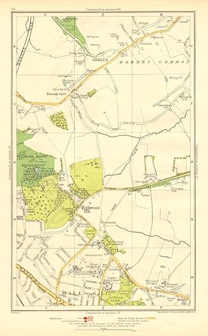
Arkley, Barnet Gate, Highwood Hill, Mill Hill
Date d'édition : 1937
Vendeur : Antiqua Print Gallery, London, Royaume-Uni
Évaluation du vendeur 3 sur 5 étoiles
Carte
EUR 4,76
Autre deviseEUR 11,56 expédition depuis Royaume-Uni vers Etats-UnisQuantité disponible : 9 disponible(s)
Ajouter au panierEtat : Good. LONDON. Arkley Barnet Gate Highwood Hill Mill Hill 1937 old vintage map chart. Colour vintage street atlas map; The Geographia map company (1937). 30.5 x 18.5cm, 12 x 7.25 inches. Condition: Good. There is another map printed on the reverse side of this map. The paper is thick, and the map on the reverse side does not show through the paper. Map section #13 This map is one section from a 1937 Street Atlas of Greater London. This section of the map depicts the following suburbs in 1937: Arkley,Barnet Gate,Highwood Hill,Mill Hill The maps in this series show London during the rapid interwar suburban expansion. Many areas shown in the outer suburbs as undeveloped land on these maps are now built up. Less frequently, some maps indicate housing developments proposed in 1937 but which were never built on land which is still undeveloped, or which has been built up according to a different street layout from that shown. The inner London maps in this series show London before the damage inflicted by the Blitz during World War 2 and the subsequent redevelopment of the 1950's and 1960's. These maps predate the construction of any motorways (the M1 sections into London having opened between 1966-1977), many major roads, and other post-war urban traffic schemes. The elevated sections of many major roads were constructed after the second world war; for example, the maps predate the construction of the Westway and elevated sections of the A4; the Western Avenue is shown on map sections #142 & #143 as proposed or under construction to the west of Northolt Aerodrome. The London docklands are shown at the height of their scale and glory, a network of large docks and railway lines. The last dock to be built had been completed in 1921. The prosperity of the docklands continued until the advent of containerisation 1960's, whereafter they remained derelict until redevelopment commenced in the early 1980's, centred around the area now known as Canary Wharf These maps show a number of now disappeared features, such as aerodromes which have since disappeared or changed their use, the Brooklands motor racing circuit (shown on map section #157, 2 years before it hosted its last race in 1939), and railways which are now disused. LHR is shown on map section #150 as the modest "Great West Aerodrome"; the original Heathrow Hall is also depicted on this map. The airport at that time was used for aircraft assembly and testing, with Croydon Airport (shown on map sections #163 and #164) being the main airport used for commercial flights.
-
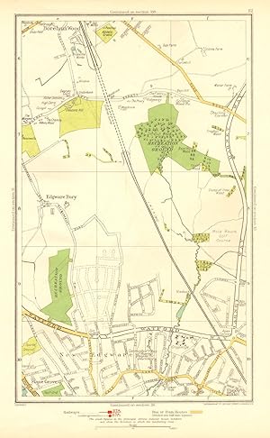
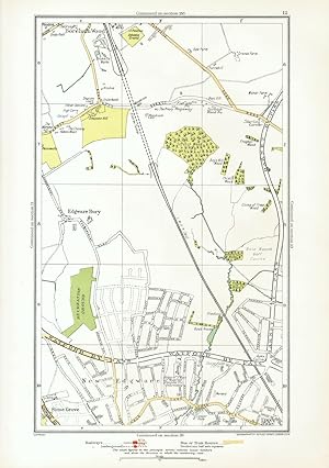
Edgware Bury, New Edgware, Stone Grove, Upper Hale
Date d'édition : 1937
Vendeur : Antiqua Print Gallery, London, Royaume-Uni
Évaluation du vendeur 3 sur 5 étoiles
Carte
EUR 4,76
Autre deviseEUR 11,56 expédition depuis Royaume-Uni vers Etats-UnisQuantité disponible : 10 disponible(s)
Ajouter au panierEtat : Good. LONDON. Edgware Bury New Edgware Stone Grove Upper Hale 1937 old vintage map. Colour vintage street atlas map; The Geographia map company (1937). 30.5 x 18.5cm, 12 x 7.25 inches. Condition: Good. There is another map printed on the reverse side of this map. The paper is thick, and the map on the reverse side does not show through the paper. Map section #12 This map is one section from a 1937 Street Atlas of Greater London. This section of the map depicts the following suburbs in 1937: Edgware Bury,New Edgware,Stone Grove,Upper Hale The maps in this series show London during the rapid interwar suburban expansion. Many areas shown in the outer suburbs as undeveloped land on these maps are now built up. Less frequently, some maps indicate housing developments proposed in 1937 but which were never built on land which is still undeveloped, or which has been built up according to a different street layout from that shown. The inner London maps in this series show London before the damage inflicted by the Blitz during World War 2 and the subsequent redevelopment of the 1950's and 1960's. These maps predate the construction of any motorways (the M1 sections into London having opened between 1966-1977), many major roads, and other post-war urban traffic schemes. The elevated sections of many major roads were constructed after the second world war; for example, the maps predate the construction of the Westway and elevated sections of the A4; the Western Avenue is shown on map sections #142 & #143 as proposed or under construction to the west of Northolt Aerodrome. The London docklands are shown at the height of their scale and glory, a network of large docks and railway lines. The last dock to be built had been completed in 1921. The prosperity of the docklands continued until the advent of containerisation 1960's, whereafter they remained derelict until redevelopment commenced in the early 1980's, centred around the area now known as Canary Wharf These maps show a number of now disappeared features, such as aerodromes which have since disappeared or changed their use, the Brooklands motor racing circuit (shown on map section #157, 2 years before it hosted its last race in 1939), and railways which are now disused. LHR is shown on map section #150 as the modest "Great West Aerodrome"; the original Heathrow Hall is also depicted on this map. The airport at that time was used for aircraft assembly and testing, with Croydon Airport (shown on map sections #163 and #164) being the main airport used for commercial flights.
-
Large Print Map of the Far East. Size 54 by 39 Inches. Produced under the Direction of Alexander Gross, F.R.G.S.
Edité par Geographia Map Company. 0
Vendeur : Eryops Books, Stephenville, TX, Etats-Unis
Évaluation du vendeur 5 sur 5 étoiles
EUR 17,47
Autre deviseEUR 5,10 expédition vers Etats-UnisQuantité disponible : 1 disponible(s)
Ajouter au panierNo Binding. Etat : Good. Large folded map; no date given but circa 1940(?); a couple of small tears where folded; nicks/small chips on edges; o/w in good condition. Map.
-
Hemel Hempstead Chipperfield Flaunden
Vendeur : Antiqua Print Gallery, London, Royaume-Uni
Évaluation du vendeur 3 sur 5 étoiles
EUR 5,37
Autre deviseEUR 11,56 expédition depuis Royaume-Uni vers Etats-UnisQuantité disponible : 5 disponible(s)
Ajouter au panier -

Heston, Lampton, North Hyde, Norwood Green, Southall Green, Sutton
Date d'édition : 1933
Vendeur : Antiqua Print Gallery, London, Royaume-Uni
Évaluation du vendeur 3 sur 5 étoiles
Carte
EUR 5,95
Autre deviseEUR 11,56 expédition depuis Royaume-Uni vers Etats-UnisQuantité disponible : 2 disponible(s)
Ajouter au panierEtat : Good. HESTON. Hounslow Lampton Norwood Green Southall North Hyde Sutton 1933 old map. Colour vintage street atlas map; The Geographia map company (1933). 30.5 x 18.5cm, 12 x 7.25 inches. Condition: Good. There is another map printed on the reverse side of this map. The paper is thick, and the map on the reverse side does not show through the paper.
-
Edgware Bury, New Edgware, Stone Grove, Upper Hale
Date d'édition : 1933
Vendeur : Antiqua Print Gallery, London, Royaume-Uni
Évaluation du vendeur 3 sur 5 étoiles
Carte
EUR 5,95
Autre deviseEUR 11,56 expédition depuis Royaume-Uni vers Etats-UnisQuantité disponible : 4 disponible(s)
Ajouter au panierEtat : Good. LONDON. Edgware Bury New Edgware Stone Grove Upper Hale 1933 old vintage map. Colour vintage street atlas map; The Geographia map company (1933). 30.5 x 18.5cm, 12 x 7.25 inches. Condition: Good. There is another map printed on the reverse side of this map. The paper is thick, and the map on the reverse side does not show through the paper.
-

Chislehurst, Chislehurst West, Longlands
Date d'édition : 1933
Vendeur : Antiqua Print Gallery, London, Royaume-Uni
Évaluation du vendeur 3 sur 5 étoiles
Carte
EUR 5,95
Autre deviseEUR 11,56 expédition depuis Royaume-Uni vers Etats-UnisQuantité disponible : 3 disponible(s)
Ajouter au panierEtat : Good. CHISLEHURST. Chislehurst West Longlands Pett's Wood Sidcup Park Wood 1933 map. Colour vintage street atlas map; The Geographia map company (1933). 30.5 x 18.5cm, 12 x 7.25 inches. Condition: Good. There is another map printed on the reverse side of this map. The paper is thick, and the map on the reverse side does not show through the paper.
-
Creekmouth, Rippleside, Upney
Date d'édition : 1933
Vendeur : Antiqua Print Gallery, London, Royaume-Uni
Évaluation du vendeur 3 sur 5 étoiles
Carte
EUR 5,95
Autre deviseEUR 11,56 expédition depuis Royaume-Uni vers Etats-UnisQuantité disponible : 3 disponible(s)
Ajouter au panierEtat : Good. LONDON. Creekmouth Rippleside Upney Becontree Thamesmead 1933 old vintage map. Colour vintage street atlas map; The Geographia map company (1933). 30.5 x 18.5cm, 12 x 7.25 inches. Condition: Good. There is another map printed on the reverse side of this map. The paper is thick, and the map on the reverse side does not show through the paper.
-

Chadwell Heath
Date d'édition : 1933
Vendeur : Antiqua Print Gallery, London, Royaume-Uni
Évaluation du vendeur 3 sur 5 étoiles
Carte
EUR 5,95
Autre deviseEUR 11,56 expédition depuis Royaume-Uni vers Etats-UnisQuantité disponible : 4 disponible(s)
Ajouter au panierEtat : Good. ROMFORD. Chadwell Heath Becontree Dagenham Valence Park 1933 old vintage map. Colour vintage street atlas map; The Geographia map company (1933). 30.5 x 18.5cm, 12 x 7.25 inches. Condition: Good. There is another map printed on the reverse side of this map. The paper is thick, and the map on the reverse side does not show through the paper.
-
Busheyheath, Caldecote Hill, Clay Hill, Little Bushey
Date d'édition : 1933
Vendeur : Antiqua Print Gallery, London, Royaume-Uni
Évaluation du vendeur 3 sur 5 étoiles
Carte
EUR 5,95
Autre deviseEUR 11,56 expédition depuis Royaume-Uni vers Etats-UnisQuantité disponible : 4 disponible(s)
Ajouter au panierEtat : Good. HERTS. Busheyheath Caldecote Hill Clay Hill Little Bushey Stanmore Cmn 1933 map. Colour vintage street atlas map; The Geographia map company (1933). 30.5 x 18.5cm, 12 x 7.25 inches. Condition: Good. There is another map printed on the reverse side of this map. The paper is thick, and the map on the reverse side does not show through the paper.
-

Kenton, Belmont, Stanmore, Canon's Park Edgware
Date d'édition : 1933
Vendeur : Antiqua Print Gallery, London, Royaume-Uni
Évaluation du vendeur 3 sur 5 étoiles
Carte
EUR 5,95
Autre deviseEUR 11,56 expédition depuis Royaume-Uni vers Etats-UnisQuantité disponible : 2 disponible(s)
Ajouter au panierEtat : Good. KENTON. Belmont Stanmore Canons Park Edgware 1933 old vintage map plan chart. Colour vintage street atlas map; The Geographia map company (1933). 30.5 x 18.5cm, 12 x 7.25 inches. Condition: Good. There is another map printed on the reverse side of this map. The paper is thick, and the map on the reverse side does not show through the paper.
-
Barking, Beckton, Cyprus, New Beckton, Wall End
Date d'édition : 1933
Vendeur : Antiqua Print Gallery, London, Royaume-Uni
Évaluation du vendeur 3 sur 5 étoiles
Carte
EUR 5,95
Autre deviseEUR 11,56 expédition depuis Royaume-Uni vers Etats-UnisQuantité disponible : 4 disponible(s)
Ajouter au panierEtat : Good. LONDON. Barking Beckton Cyprus New Beckton Wall End 1933 old vintage map chart. Colour vintage street atlas map; The Geographia map company (1933). 30.5 x 18.5cm, 12 x 7.25 inches. Condition: Good. There is another map printed on the reverse side of this map. The paper is thick, and the map on the reverse side does not show through the paper.
-
Dormer's Wells, Mount Pleasant, Southall, West End
Date d'édition : 1933
Vendeur : Antiqua Print Gallery, London, Royaume-Uni
Évaluation du vendeur 3 sur 5 étoiles
Carte
EUR 5,95
Autre deviseEUR 11,56 expédition depuis Royaume-Uni vers Etats-UnisQuantité disponible : 4 disponible(s)
Ajouter au panierEtat : Good. MIDDLESEX. Dormer's Wells Mount Pleasant Southall West End 1933 old map. Colour vintage street atlas map; The Geographia map company (1933). 30.5 x 18.5cm, 12 x 7.25 inches. Condition: Good. There is another map printed on the reverse side of this map. The paper is thick, and the map on the reverse side does not show through the paper.
-

Arkley, Barnet Gate, Highwood Hill, Mill Hill
Date d'édition : 1933
Vendeur : Antiqua Print Gallery, London, Royaume-Uni
Évaluation du vendeur 3 sur 5 étoiles
Carte
EUR 5,95
Autre deviseEUR 11,56 expédition depuis Royaume-Uni vers Etats-UnisQuantité disponible : 3 disponible(s)
Ajouter au panierEtat : Good. LONDON. Arkley Barnet Gate Highwood Hill Mill Hill 1933 old vintage map chart. Colour vintage street atlas map; The Geographia map company (1933). 30.5 x 18.5cm, 12 x 7.25 inches. Condition: Good. There is another map printed on the reverse side of this map. The paper is thick, and the map on the reverse side does not show through the paper.
-

Barnet, Bentley Heath, Dancers Hill, Ganwick Corner, Kitt's End, Monken Hadley
Date d'édition : 1933
Vendeur : Antiqua Print Gallery, London, Royaume-Uni
Évaluation du vendeur 3 sur 5 étoiles
Carte
EUR 5,95
Autre deviseEUR 11,56 expédition depuis Royaume-Uni vers Etats-UnisQuantité disponible : 5 disponible(s)
Ajouter au panierEtat : Good. BARNET. Monken Hadley Wrotham Park Kitts End Dancer's Hill Ganwick Cnr 1933 map. Colour vintage street atlas map; The Geographia map company (1933). 30.5 x 18.5cm, 12 x 7.25 inches. Condition: Good. There is another map printed on the reverse side of this map. The paper is thick, and the map on the reverse side does not show through the paper.
-

Dagenham
Date d'édition : 1933
Vendeur : Antiqua Print Gallery, London, Royaume-Uni
Évaluation du vendeur 3 sur 5 étoiles
Carte
EUR 5,95
Autre deviseEUR 11,56 expédition depuis Royaume-Uni vers Etats-UnisQuantité disponible : 2 disponible(s)
Ajouter au panierEtat : Good. LONDON. Dagenham Hornchurch Thamesmead Dagenham Dock 1933 old vintage map. Colour vintage street atlas map; The Geographia map company (1933). 30.5 x 18.5cm, 12 x 7.25 inches. Condition: Good. There is another map printed on the reverse side of this map. The paper is thick, and the map on the reverse side does not show through the paper.

