Montant total (1 article articles) :
Destination de la commande :

harpe jean baptiste bénard dépôt cartes (1 résultats)
Commentaires
Passer aux résultats principaux de la recherche
Filtres de recherche
Type d'article
- Tous les types de produits
- Livres (Aucun autre résultat ne correspond ŕ ces critčres)
- Magazines & Périodiques (Aucun autre résultat ne correspond ŕ ces critčres)
- Bandes dessinées (Aucun autre résultat ne correspond ŕ ces critčres)
- Partitions de musique (Aucun autre résultat ne correspond ŕ ces critčres)
- Art, Affiches et Gravures (Aucun autre résultat ne correspond ŕ ces critčres)
- Photographies (Aucun autre résultat ne correspond ŕ ces critčres)
- Cartes (Aucun autre résultat ne correspond ŕ ces critčres)
- Manuscrits & Papiers anciens (1)
Etat En savoir plus
- Neuf (Aucun autre résultat ne correspond ŕ ces critčres)
- Comme neuf, Trčs bon ou Bon (1)
- Assez bon ou satisfaisant (Aucun autre résultat ne correspond ŕ ces critčres)
- Moyen ou mauvais (Aucun autre résultat ne correspond ŕ ces critčres)
- Conformément ŕ la description (Aucun autre résultat ne correspond ŕ ces critčres)
Reliure
- Toutes
- Couverture rigide (Aucun autre résultat ne correspond ŕ ces critčres)
- Couverture souple (Aucun autre résultat ne correspond ŕ ces critčres)
Particularités
- Ed. originale (1)
- Signé (Aucun autre résultat ne correspond ŕ ces critčres)
- Jaquette (Aucun autre résultat ne correspond ŕ ces critčres)
- Avec images (1)
- Sans impressions ŕ la demande (1)
Langue (1)
Prix
- Tous les prix
- Moins de EUR 20 (Aucun autre résultat ne correspond ŕ ces critčres)
- EUR 20 ŕ EUR 40 (Aucun autre résultat ne correspond ŕ ces critčres)
- Plus de EUR 40
Livraison gratuite
Pays
Evaluation du vendeur
-
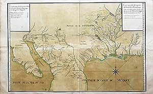
Carte nouvelle de la partie de l'Ouest de la Loüisianne faitte sur les observations, recherches, et decouvertes de Mr Benard de la Harpe l'vn des Commandants au d(it) Pa˙s faitte sur les observations, recherches, et decouvertes de Mr Benard de la Harpe l'vn des Commandants au d(it) Pa˙s
Edité par Dépôt des cartes et plans de la Marine, [Paris], 1722
Vendeur : Arader Books, New York, NY, Etats-Unis
Évaluation du vendeur 5 sur 5 étoiles

Manuscrit / Papier ancien Edition originale
EUR 1 100 857,96
Autre deviseGratuit expédition vers Etats-UnisQuantité disponible : 1 disponible(s)
Ajouter au panierNo binding. Etat : Near fine. First. THE MOST IMPORTANT 18TH-CENTURY MAP OF THE AMERICAN SOUTHWEST. Manuscript map in ink and watercolor of the southern United States and northern Mexico. [Paris: ca. 1722-1725.] Two joined sheets (22 5/8" x 36 3/4", 575mm x 933mm; 31 3/4" x 45 3/4" framed). Some creases throughout, with marginal tanning and soiling. A couple of spots of foxing. Jean-Baptiste Bénard de La Harpe (1683-1765) came from France in 1718 to map and to set up trading posts in present-day Texas, Oklahoma and Arkansas. Whereas the Northeast was the site of contention between the French and the British, the contest in the Southwest was between France and Spain. Using New Orleans as his base, La Harpe forged connections with native Americans between the Arkansas River, which cuts through Kansas, Oklahoma and Arkansas before joining the Mississippi; and the Red River, which describes the border between eastern Oklahoma and Texas. The map is particularly detailed in its chronicling of native American settlements west of Texas: the Mexican states of Chihuahua and Sonora, New Mexico, Arizona and California into Baja California. La Harpe is particularly careful in his indications of the nature of these settlements: "Indiens Gentils" and "Chretiens," sites of silver mines, capitals/presidios and of ruined or abandoned villages. After several years of exploration as well as gathering materials from other explorers, La Harpe returned to France in 1723, and it is in the years immediately following that this map is presumed to have been made. Copied by the Dépôt des cartes et plans de la Marine (there are two further copies: one in the Bibliothčque nationale de France, attributed to Jean-Baptiste Bourguignon d'Anville; and one in the Library of Congress -- sadly buried in its Louisiana Miscellaney Collection -- illustrated in Cumming et al. The Exploration of North America 1630-1776 p. 170 with n. 276), the relationship between La Harpe's original and the present item is unclear. Certain points appear on our map that are not on the BnF or LoC examples (and vice-versa), so all appear to be independent copies. Ours extends further east than the BnF copy, which stops before Florida; the LoC copy has far less detail relating to cities or other landmarks along rivers. Both BnF and LoC examples extend in all directions further than ours (including the Yucatan peninsula to the south) and so are less focused on Louisiana and Texas than is the present map. By comparison to printed maps of the period and even well beyond, these manuscript maps are far more accurate and detailed. Perhaps the Dépot des cartes held this information close for proprietary or military reasons. Nonetheless, the Spanish would go on to dominate the American South (La Harpe conducted the surrender of Pensacola, not shown on the BnF map, to the Spanish) freeing the French to focus on their territorial struggles with the British in the North and East. From the collection of the late great cartographic historian Dr. Seymour I. Schwartz (his sale, Sotheby's New York, 28 June 2018, lot 145). Cf. William P. Cumming et al. The Exploration of North America 1630-1776. New York: G.P. Putnam's Sons, 1974. C. 5, no. 9, pp. 170-171, illust. p. 170, with n. 267 (the Library of Congress copy).