Montant total (1 article articles) :
Destination de la commande :

homann heirs (151 rťsultats)
Commentaires
Passer aux rťsultats principaux de la recherche
Filtres de recherche
Type d'article
- Tous les types de produits
- Livres (60)
- Magazines & Pťriodiques (Aucun autre rťsultat ne correspond ŗ ces critŤres)
- Bandes dessinťes (Aucun autre rťsultat ne correspond ŗ ces critŤres)
- Partitions de musique (Aucun autre rťsultat ne correspond ŗ ces critŤres)
- Art, Affiches et Gravures (4)
- Photographies (Aucun autre rťsultat ne correspond ŗ ces critŤres)
- Cartes (87)
- Manuscrits & Papiers anciens (Aucun autre rťsultat ne correspond ŗ ces critŤres)
Etat En savoir plus
- Neuf (Aucun autre rťsultat ne correspond ŗ ces critŤres)
- Comme neuf, TrŤs bon ou Bon (17)
- Assez bon ou satisfaisant (36)
- Moyen ou mauvais (Aucun autre rťsultat ne correspond ŗ ces critŤres)
- Conformťment ŗ la description (98)
Particularitťs
- Ed. originale (2)
- Signť (Aucun autre rťsultat ne correspond ŗ ces critŤres)
- Jaquette (2)
- Avec images (128)
- Sans impressions ŗ la demande (151)
Langue (2)
Livraison gratuite
Pays
Evaluation du vendeur
-

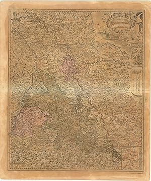
Carte du Cercle de Budissin dans la Margaffin de la Haute Lusace.
Editť par Heirs of Homann, 1746., 1746
Vendeur : Sam Gatteno Books, Grosse Pointe, MI, Etats-Unis
…valuation du vendeur 5 sur 5 ťtoiles

EUR 174,74
Autre deviseEUR 42,41 expťdition depuis Etats-Unis vers FranceQuantitť disponible : 1 disponible(s)
Ajouter au panierSoft cover. Etat : Good. Nineteenth-century brown morocco slipcase.
-
Carte du Cercle de Goerlitz dans la Margaffin de la Haute Lusace.
Editť par Heirs of Homann, 1746., 1746
Vendeur : Sam Gatteno Books, Grosse Pointe, MI, Etats-Unis
…valuation du vendeur 5 sur 5 ťtoiles
EUR 174,74
Autre deviseEUR 42,41 expťdition depuis Etats-Unis vers FranceQuantitť disponible : 1 disponible(s)
Ajouter au panierSoft cover. Etat : Good. Nineteenth-century brown morocco slipcase.
-
Regni Serviae pars, una cum finitimis Valachiae & Bulgariae partibus, addita praecipuorum in his regionibus munimenturum & castellorum Ichnographia. Curantibus Homannianis Heredibus, Norib.
Editť par Homann Heirs, Nurenberg, 1740
Vendeur : Kurt Gippert Bookseller (ABAA), Chicago, IL, Etats-Unis
Membre d'association : ABAA ILAB MWABA
…valuation du vendeur 5 sur 5 ťtoiles
Edition originale
EUR 393,16
Autre deviseEUR 42,41 expťdition depuis Etats-Unis vers FranceQuantitť disponible : 1 disponible(s)
Ajouter au panierUnbound. Etat : Very good condition. First Edition. Large map with original hand-coloring. Measures 22.5 (width) x 20.25 (height) inches. One part only of a set of 2 maps. This one shows the eastern part of Serbia, Walachia, and part of Bulgaria. It contains 7 inset maps of Widden, Nicopol, Nissa, Chatchek, Seraglio, Krakoievaz, and Valiova. Published by Homann Heirs, Nuremberg, ca. 1740. Minor staining and creasing to the margins, and a tiny perforation in the map. A very attractive map, suitable for framing. Book.
-

Li Regni di Sicilia e Sardegna colle Adiacenti Isole di Corsica, Elba, Malta e Liparee, o di Vulcano,
Editť par non men che parte delle spiagge settentrionali dell'Africa e delle Meridionali d'Italia…. Norimbergo, A spese degl'Eredi d'Homann MDCCLXII., Norimberga, 1762
Vendeur : Libreria Antiquaria Pregliasco, Torino, TO, Italie
Membre d'association : ALAI ILAB
…valuation du vendeur 5 sur 5 ťtoiles
EUR 800
Autre deviseEUR 25 expťdition depuis Italie vers FranceQuantitť disponible : 1 disponible(s)
Ajouter au panierEtat : molto buono. Incisione originale in rame(mm 380x580 e margini) arricchita da bella colorazione coeva. Bellissima carta ††che comprende territori dell'Italia meridionale, Sicilia, Sardegna, Corsica, Malta, Nord Africa. Titolo su quattro righe lungo il margine superiore del rame. Nel quadrante inferiore sinistro Ť presente un elaborato cartiglio con titolo, †un veliero gli stemmi araldici di Sicilia, Sardegna e Malta, un guerriero, forse Persus, con lo scudo di Medusa. In basso al centro la scala miliare. Disegnata da G. A. b. Rizzi Zannoni N. Padovano, tratta dall'atlante edito dagli eredi di Homann† †"Maior Atlas Scholasticus ex Triginta Sex Generalibus et Specialibu"s. del 1752. Bell'esemplare con qualche piccola macchietta nel margine bianco.Gli Eredi Homann (1730 - 1848) casa editrice di carte geografiche con sede a Norimberga, attivi dalla metŗ alla fine del XVIII secolo. Dopo la morte del grande cartografo Johann Baptist Homann (1664 - 1724), la direzione dell'azienda passÚ al figlio Johann Christoph Homann (1703 - 1730).† J. C. Homann, forse rendendosi conto che non sarebbe sopravvissuto a lungo al padre, stabilž nel suo testamento che l'azienda sarebbe stata ereditata dai suoi due direttori, Johann Georg Ebersberger (1695 - 1760) e Johann Michael Franz (1700 - 1761), e che sarebbe stata pubblicata solo con il nome di "Eredi Homann".† Questa denominazione, ††compare sulle mappe a partire dal 1731 circa.† L'azienda continuÚ a pubblicare mappe in quantitŗ sempre minore fino alla morte dell'ultimo proprietario, Christoph Franz Fembo (1781 - 1848).† La Gumina n. 428. Book.
-
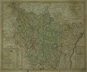
Charte von Lothringen und Barr Nebst den drey BisthŁmern Metz, Toul und Verdun. Nach den besten franzŲsischen Charten entmorsen und verbessert von F.L. GŁssefeld.
Editť par Nuremberg:, 1793
Vendeur : Robert Frew Ltd. ABA ILAB, London, Royaume-Uni
Membre d'association : ABA ILAB PBFA
…valuation du vendeur 4 sur 5 ťtoiles

Carte
EUR 88,82
Autre deviseEUR 7,47 expťdition depuis Royaume-Uni vers FranceQuantitť disponible : 1 disponible(s)
Ajouter au panier46.5 x 57.4 cm. Double page copper engraved map of Lorraine. Original colour in block and outline. Old brief title inscriptions in ink to verso of map. Staining and offsetting across sheet.
-
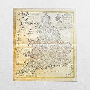
(United Kingdom) Regni Angliae Et Principatus Cambriae Tabula Nova Ad Prototypon Kitchinianum
Date d'ťdition : 1793
Langue: anglais
Vendeur : Hornseys, Ripon, Royaume-Uni
Membre d'association : PBFA
…valuation du vendeur 5 sur 5 ťtoiles
EUR 112,51
Autre deviseEUR 28,75 expťdition depuis Royaume-Uni vers FranceQuantitť disponible : 1 disponible(s)
Ajouter au panierNo Binding. Etat : Good. Original copper engraving. Date: 1793. Sheet size: 54.8cm x 63.2cm. Contemporary outline hand-colouring. Age toning, staining and marks to the margins with a mark to the west of Wales. In good condition overall. Scarce. SR: Sleeve 1111. Map Drawer D.
-
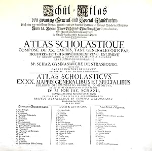
Schul-Atlas von zwantzig General- und Special-Landkarten, nach einer verbesserten Methode illuminirt, und zum bequemen Gebrauch der Anfangs-GrŁnde der Geographie . der Jugend zum Besten also eingerichtet / Atlas scholastique, composť de XX. cartes . / Atlas scholasticus ex XX. mappis .
Editť par NŁrnberg: Homšnnische Officin dat. ,, 1745
Vendeur : Antiquariat Ruthild Jšger, Lueneburg, Allemagne
Membre d'association : ILAB VDA
…valuation du vendeur 4 sur 5 ťtoiles
EUR 80
Autre deviseEUR 20 expťdition depuis Allemagne vers FranceQuantitť disponible : 1 disponible(s)
Ajouter au panier(Gr.-Folio). 1 Blatt (mittig gefaltet), 56 x 51 cm. (minimale Randeinrisse sorgfšltig unterlegt, sonst sehr gut erhalten; small tears in the margins repaired, otherwise in good condition). * Auf dem deutsch/franzŲsisch/lateinischen Titelblatt werden die zwanzig im Atlas enthaltenen Landkarten aufgefŁhrt. Der Homann'sche Schul-Atlas war konzipiert als Ergšnzung des Geographie-Lehrbuches fŁr Schulen aus der Feder des Gymnasialdirektors Johann Jacob Schatz (1720 Rektor in Trarbach, 1728 Direktor und Bibliothekar Gymnasium Eisenach, 1737 Direktor Gymnasium StraŖburg). (#9677AB).
-
Ducatus Iuliaci & Bergensis Tabula Geographia, simul Ducatum Cliviae & Meursiae .
Editť par Nurembergc., 1750
Vendeur : Robert Frew Ltd. ABA ILAB, London, Royaume-Uni
Membre d'association : ABA ILAB PBFA
…valuation du vendeur 4 sur 5 ťtoiles
Carte
EUR 118,43
Autre deviseEUR 7,47 expťdition depuis Royaume-Uni vers FranceQuantitť disponible : 1 disponible(s)
Ajouter au panier57 x 48.2 cm. Original colour in block and outline. Double page map showing the duchies of Julich, Berg and Cleves. Paper browned unevenly.
-
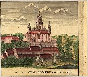
Das SchloŖ FŁrstenstein von Morgen Scenographia Urbium Silesiae, tab. VI, 1738, Homann Heirs. Das ist VORSTELLUNG der Prospecte von den Staedten SCHLESIENS. sechste Tabell. in welcher die FŁrnehmsten Staedte des FŁrst. SCHWEIDNITZ accurat vorgestellet werden, entworfen von F.B.Werner Siles. und angefertigt von den Homaennischen Erben. NŁrnberg 1738. Cum pr. S.C.M.
Editť par Fr. B. Werner, NŁrnberg, 1738
Vendeur : Antiquariat Reinhold Berg eK Inh. R.Berg, Regensburg, Allemagne
Membre d'association : ILAB VDA
…valuation du vendeur 5 sur 5 ťtoiles
Carte
EUR 125
Autre deviseEUR 18 expťdition depuis Allemagne vers FranceQuantitť disponible : 1 disponible(s)
Ajouter au panierOther. Original antique copper engraving, hand colored in outline and wash, when published. Depict one view (from nine) of the,Scenographia Urbium Silesiae, tab. VI' published 1738 by Homann Heirs, engraved from F.B. Werner. Cut close to engraved borderline of the map. Upper left side with a small mended tear in the margin, else in good condition. 150 by 150mm (6 by 6 inches). 150 by 150mm (6 by 6 inches).
-
Carte D' Artois et des Environs Vel Mappa Specalis Comitatus Artesiae in qua simul Terrae Iurisdictionales.de l'Isle designata. Recudentibus Homannianis Heredib.
Editť par Homann Heirs 1740-50, NŁrnberg, 1740
Vendeur : Antiquariat Reinhold Berg eK Inh. R.Berg, Regensburg, Allemagne
Membre d'association : ILAB VDA
…valuation du vendeur 5 sur 5 ťtoiles
Carte
EUR 145
Autre deviseEUR 18 expťdition depuis Allemagne vers FranceQuantitť disponible : 1 disponible(s)
Ajouter au panierOther. Original antique copper engraving, hand colored and wash when published. Ornated in the upper right corner with a large allegoric title cartouche, as well a small mileage scale in the upper left corner. Fine detailed engraved map showing the duchy of Artois with its surroundings. With many place names and details like streets, woods, mountains, rivers, lakes etc. Still in very good condition, a minor gluestaining at the centre-fold. 482 by 570mm (19 by 22 inches).
-
Territorium Republicae liberae Helveticae Scaphusiensis ex mensuratione olim Pejeriana ad hanc formam reducta mappa.
Editť par Nuremberg: Homann Erben, 1753., 1753
Vendeur : William Matthews/The Haunted Bookshop, Sidney, BC, Canada
Membre d'association : ABAC ILAB
…valuation du vendeur 5 sur 5 ťtoiles
EUR 158,37
Autre deviseEUR 12,72 expťdition depuis Canada vers FranceQuantitť disponible : 1 disponible(s)
Ajouter au panierA copper engraved map on laid paper, uncoloured cartouche in upper left. Margins and parts of map are hand-coloured. Plate size is 56cm x 45cm, on a sheet measuring 62.5cm x 51cm. Verso blank. Text at top of plate: Le Canton ou Territoire de la Republique de Schafhouse en Suisse, Leve cy devant par Mr. Pejer, Capitaine, et publie par les Heritiers de Homann l'an 1753. The imprint within the cartouche is: Excuda Studio Homannianorum Heredum, 1753. Numeral in pen at upper right blank margin, "140". Modest edge wear, a clean and attractive copy. A regional map of Switzerland.
-
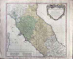
Status Ecclesiastici nec non Magni Ducatus Toscanae Nova Tabula Geographica.
Editť par Nuremberg: Homann Erben, 1748., 1748
Vendeur : William Matthews/The Haunted Bookshop, Sidney, BC, Canada
Membre d'association : ABAC ILAB
…valuation du vendeur 5 sur 5 ťtoiles
EUR 158,37
Autre deviseEUR 12,72 expťdition depuis Canada vers FranceQuantitť disponible : 1 disponible(s)
Ajouter au panierA copper engraved map on laid paper, large colour cartouche in upper right, including two coats-of-arms. Entire map is hand-coloured. Plate size is 57cm x 49cm, on a sheet measuring 63cm x 52cm. Verso blank. Text at top of plate: Les Etats de L'EGLISE & du Grand Duche de TOSCANE dresses par Mr. Tob. Mayer, de la Soc. Geogr. chez les Herit de Homann. / L'An. MDCCXLVIII Avec Privilege Imperial. The imprint within the cartouche is: Homannianis Heredibus Norimbergae . 1748. Numeral in pen at upper right blank margin, small letter "V" within lower right corner of plate. A clean and attractive copy. A map of central Italy by Tobias Mayer, including Tuscany, and the cities Livorno, Bologna, Florenz, Ferrara, Ravenna, Urbino, Siena, Orvieto, Spoleto, and Rome.
-
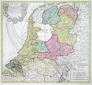
Septem Provinciae seu Belgium Foederatum quod generaliter Hollandia audit
Editť par Homann Heirs, Nuremberg, 1748
Vendeur : Antikvariat Krenek, Prag, Rťbublique tchŤque
Membre d'association : ILAB
…valuation du vendeur 5 sur 5 ťtoiles
Carte
EUR 159
Autre deviseEUR 12,50 expťdition depuis Rťbublique tchŤque vers FranceQuantitť disponible : 1 disponible(s)
Ajouter au panierKein Einband. Etat : Gut bis sehr gut. The Netherlands. "Septem Provinciae seu Belgium Foederatum quod generaliter Hollandia audit". Orig. copperplate engraving published by Homann's Heirs, 1748 after T. Maier's map. Original old colouring. With great heraldic title cartouche (with 7 coats-of-arms). 47:51,5 cm (18 1/2 x 20 1/4 inch.). Detailed map of the Low Countries, with 7 coats of arms of Geldern, Holland, Zeeland, Utrecht, Friesland, Ober Issel and Groningen.
-
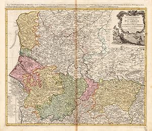
Carte du Govvernement General de Picardie qui comprend La Generalite D' Amiens avec L' Artois & les Frontieres des Pays Bas.
Editť par Homann Heirs, NŁrnberg, 1746
Vendeur : Antiquariat Reinhold Berg eK Inh. R.Berg, Regensburg, Allemagne
Membre d'association : ILAB VDA
…valuation du vendeur 5 sur 5 ťtoiles
Carte
EUR 155
Autre deviseEUR 18 expťdition depuis Allemagne vers FranceQuantitť disponible : 1 disponible(s)
Ajouter au panierOther. Original antique copper engraving, hand colored and wash when published. Ornated in the upper right corner with a large allegoric title cartouche, as well a small table of explanations in the lower left corner. Fine detailed engraved map showing the government of the Picardie, including Amiens, Artois and the borders to Belgium. With many place names and details like streets, woods, mountains, rivers, lakes etc. In very good condition, slightly visable gluestaining at the centre-fold. 480 by 552mm (19 by 21 inches). 480 by 552mm (19 by 21 inches).
-

Tabula Poliometrica Germaniae ac Praecipuorum Quorundam Locorum Europae / Neu Vermehrter Curioser Meilen-Zeiger der Vurnehmsten Stadte in Europa Besonders in Teutschland, wie Vielgememe Teutche Meilen Solche Voneinander Entlegen.
Editť par Nuremberg [N√ľrnberg], 1731
Vendeur : William Chrisant & Sons, ABAA, ILAB. IOBA, ABA, Ephemera Society, Fort Lauderdale, FL, Etats-Unis
Membre d'association : ABAA ESA ILAB
…valuation du vendeur 5 sur 5 ťtoiles
EUR 131,05
Autre deviseEUR 50,89 expťdition depuis Etats-Unis vers FranceQuantitť disponible : 1 disponible(s)
Ajouter au panierEtat : Very Good. Original hand colored engraving of a chart depicting the distance between numerous German cities to others across Europe and western Asia. The chart measures approximately 21.5 x 18.25 in (54.5 x 46.5 cm); page size is 25.25 x 21.25 in (64 x 54 cm). Some minor thumbing and tearing to edges not affecting the image (see image).
-

Regni Angliae et Principatus Cambriae Tabula nova ad prototypon Kitchinianum
Editť par Nuremberg, 1805
Vendeur : Clive A. Burden Ltd., Chalfont St. Giles, BUCKS, Royaume-Uni
Membre d'association : ABA ILAB
…valuation du vendeur 2 sur 5 ťtoiles

Carte
EUR 177,64
Autre deviseEUR 19,72 expťdition depuis Royaume-Uni vers FranceQuantitť disponible : 1 disponible(s)
Ajouter au panierNo binding. 590 x 520 mm., early outline colour, in good condition. A rare map published by the famous German firm of cartographic publishers Homann Heirs which was founded by Johann Baptist Homann (1664-1724) in 1702 in Nuremberg. His successor was his son Johann Christoph Homann (1703-30) who died young. The business was continued as Homann Heirs by several heirs and through several generations until it closed c.1852. This map of England and Wales is dated 1805 above. At this time the firm was in the hands of Georg Christoph Franz and Friedrich Albrecht Monath. Provenance: Doreen Green 2003; private English collection. Heinz (1997); Tooley's Dictionary.
-
Tabula Comitatus Hollandiae cum ipsius confinijs Dominii nimirum Ultraiectini nec no Geldriae et Frisiae Geographice tradita curis Homannianorum Heredum.
Editť par NŁrnberg, Homannianorum Heredum., 1733
Vendeur : Inanna Rare Books Ltd., Skibbereen, CORK, Irlande
…valuation du vendeur 5 sur 5 ťtoiles
Art / Affiche / Gravure
EUR 180
Autre deviseEUR 18 expťdition depuis Irlande vers FranceQuantitť disponible : 1 disponible(s)
Ajouter au panierOriginal hand-coloured copper-engraving. Plate Size: 49.1 cm x 57.8 cm. Sheet Size: 54.5 cm x 77 cm. Original map. In good- condition. Some browning and damp-staining evident to outer margins. Some minor imperfections to outer margins also. Sign of damge to map detail near center fold at right border. Discreet duplicate library stamps in Polish and inked annotation on reverse. Interesting and detailed map of The Netherlands from Zierikzee in the south to Den Helden in the north. The map is crowded with topographical detail, showing the location of rivers, hills, cities -such as Amsterdam and Rotterdam - towns and the network of roads canals criss-crossing Holland. The political sub-division of Holland are also shown. The precariousness of Dutch security is evident through the myriad of fortified towns and cities across the map. The sandbanks of the shallow Zuiderzee (De Zuyder Zee) can be seen. Haarlemmer Meer and Leydsche Meer are also identified on the map - much of this was drained and reclaimed in the 19th and 20th centuries. Large decorative title cartouche illustrating the Dutch maritime, trading and agricultural richness and traditions lies off the coast in the North Sea ('Mare Germanicum vulgo De Noord Zee'). Bar scales and map reference keys can be seen beneath cartouche. Homann Erben/Heirs was a prominent German publishing firm in the European map market throughout the eighteenth century. Founded in 1702 by Johann Baptist Homann, the business passed to his son, Christoph, upon Johann's death in 1724. Christoph died in 1730, aged only 27, and the firm was inherited by subsequent Homann heirs. This changed the name of the company, which was known as Homann Erben, or Homann heirs. The firm continued in business until 1848.
-
Charte von Holland.
Editť par NŁrnberg, Homann Erben., 1791
Vendeur : Inanna Rare Books Ltd., Skibbereen, CORK, Irlande
…valuation du vendeur 5 sur 5 ťtoiles
Art / Affiche / Gravure
EUR 180
Autre deviseEUR 18 expťdition depuis Irlande vers FranceQuantitť disponible : 1 disponible(s)
Ajouter au panierOriginal hand-coloured copper-engraving. Plate Size: 45 cm x 56.5 cm. Sheet Size: 47.3 cm x 58.3 cm. Original map. In good condition. Some browning evident. Some minor imperfections to outer margins. Interesting and detailed map of The Netherlands from Brouwershaven in the south to Den Helden in the north. The map is crowded with topographical detail, showing the location of rivers, hills, towns and cities and the network of canals criss-crossing Holland. The sandbanks of the shallow Zuiderzee (De Zuyder Zee) can be seen. Haarlemmer Meer and Leydsche Meer are also identified on the map - much of this was drained and reclaimed in the 19th and 20th centuries. Just four years after this map was published, the old Dutch Republic was ended with the creation of a Revolutionary-France-backed Batavian Republic/Commonwealth, which eventually became a client state within the Napoleonic Empire. Inset box, located in top left corner, shows the West Frisian Islands of Texel, Elieland and Der Schelling. Decorative cartouche, bar scales and map reference keys lie off the coast. This map of the Dutch coast was the work of Prussian cartographer Franz Ludwig GŁssefeld (1744-1807). It was drawn based on the calculations of the renowned Dutch mathematician Willebrord Snellius (1580-1626), a professor of mathematics at the University of Leiden, who conceived the idea of measuring the earth using triangulation. Snellius's discoveries helped to determine the radius of the earth as well as led to more accurate ways of measuring the distance between two cities. (World Digital Library) Homann Erben/Heirs was a prominent German publishing firm in the European map market throughout the eighteenth century. Founded in 1702 by Johann Baptist Homann, the business passed to his son, Christoph, upon Johann's death in 1724. Christoph died in 1730, aged only 27, and the firm was inherited by subsequent Homann heirs. This changed the name of the company, which was known as Homann Erben, or Homann heirs. The firm continued in business until 1848.
-
Status Mutinensis in Suas Ditiones utpote Ducatum Mutinensem, Reginensem, Mirandulanum, Princiratum Carpiensem et Corregiensem exacte divisi, nec non finitimarum Regionum novissima Tabula.
Editť par Nuremberg: Homann Erben, [c.1740]., 1740
Vendeur : William Matthews/The Haunted Bookshop, Sidney, BC, Canada
Membre d'association : ABAC ILAB
…valuation du vendeur 5 sur 5 ťtoiles
EUR 190,04
Autre deviseEUR 12,72 expťdition depuis Canada vers FranceQuantitť disponible : 1 disponible(s)
Ajouter au panierA copper engraved map on laid paper, cartouche in upper left. Entire map is hand-coloured. Plate size is 50cm x 47cm, on a sheet measuring 62cm x 51.5cm. Verso blank. Text at top of plate: Tavola Dello STATO Di MODENA, accuratamente diviso ne suoi Ristretti, cioe nel Ducato di Modena Reggio, Mirandola, nel Principato di Carpi e Correggio, come pure de Paesi vicini. A studio, e Spese degli Eredi Homann Norimberga. The imprint within the cartouche is: studio et Sumptibus Homanianorum Heredum Noribergae. Numeral in pen at upper right blank margin, "112". A clean and attractive copy. A regional map of Italy, the Dukedom of Modena.
-
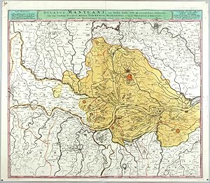
Ducatus Mantuani, ceu Sedis belli 1733-35 recentissima Delineatio
Editť par Homann Heirs, Nuremberg, 1735
Vendeur : Antikvariat Krenek, Prag, Rťbublique tchŤque
Membre d'association : ILAB
…valuation du vendeur 5 sur 5 ťtoiles
Carte
EUR 187,52
Autre deviseEUR 12,50 expťdition depuis Rťbublique tchŤque vers FranceQuantitť disponible : 1 disponible(s)
Ajouter au panierKein Einband. Etat : Sehr gut. Mantua. "Ducatus Mantuani, ceu Sedis belli 1733-35 recentissima Delineatio, una cum Ducatus Mediol. Parmensis, Modenensis, et Territ. Veronensis et Bresciani". Orig. copperplate engraving, Homann's Heirs, 1735. With title bar above the map. 49,5:57,5 cm (19 1/2 x 22 3/4 inch.). Map of the province of Mantova in Lombardy. With red coloured fortified towns of Mantova, Mirandola, Guidizollo and others. - Beautiful impression with rich colours.
-
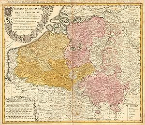
Belgium Catholicum seu Decem Provinciae Germaniae Inferioris cum consiniis Germaniae Sup. et Franciae Legitime omnia delineata et ad duetum observationum astronomicarum, nen non Geometriacarum operationum a Cassinio Snellio Muschenbrokio aliisquerite habitarum examinata studiosissime et representata a Tob. Maiero. Math. Cult. Edentibus Homannianis Heredib. A. 1747 Carte des Pais Bas Catholiques ou des X Provinces de l'Allemagne Inserieure etc dessinťe au juste selon les exactes observations Astronomiques et Operations Geometriques des Messur. Cassini. Snellius. Muschenbrok etc. dressee par Sr. Tobias Maier Mathematicien. Aux depens des Heritiers de Homann. 1 An 1747. Avec Privil Imperial
Editť par NŁrnberg, 1747
Vendeur : Antiquariat Reinhold Berg eK Inh. R.Berg, Regensburg, Allemagne
Membre d'association : ILAB VDA
…valuation du vendeur 5 sur 5 ťtoiles
Carte
EUR 190
Autre deviseEUR 18 expťdition depuis Allemagne vers FranceQuantitť disponible : 1 disponible(s)
Ajouter au panierOther. Original antique copper engraving, hand colored in outline and wash when published. This antique map shows Belgium with its neighboring counties Luxembourg and Holland. The map is equipped with many place names, rivers, woods, lakes, etc. Around the title, which is in the upper left corner, are many coat of arms. In the lower left corner we see an allegoric cartouche, which has the mileage scale inside. The explanation from the map is in the lower right corner. In good condition. Cut close to the descriptive text at the top of the map. A small mending at the bottom of the centre fold, a few minor spots, mostly only visible verso. 474 by 556mm (18 by 22 inches). 474 by 556mm (18 by 22 inches).
-

Dominia Anglorum in Praecipuis Insulis Americae - British colonies in the Caribbean during the mid-18th century.
Editť par c. 1749, 1749
Vendeur : Curtis Wright Maps, Berwyn, IL, Etats-Unis
Membre d'association : ESA MWABA
…valuation du vendeur 5 sur 5 ťtoiles
EUR 218,42
Autre deviseEUR 21,21 expťdition depuis Etats-Unis vers FranceQuantitť disponible : 1 disponible(s)
Ajouter au panierEtat : Very Good. This attractive composite image was published in Nuremberg around 1749 by the Homann Heirs. It shows a detailed overview of five Caribbean islands within the British sphere of colonial influence - St. Kitts, Antigua, Bermuda, Barbados, and Jamaica. Each map was originally designed by Hermann Moll in 1729 and offers a decidedly British perspective on the economically important islands, though toponyms are presented in a mix of English, Latin, and German. Plantations, mills, and other local industries are labeled, in addition to geographic features, settlements, and military installations. Political divisions are outlined with hand color and topography is depicted pictorially. During the mid-18th century, Britain's Caribbean colonies, notably Jamaica, Barbados, and Antigua, played a crucial role in the Atlantic slave trade and sugar production. These colonies were characterized by large plantations worked by enslaved Africans, who endured unspeakably brutal conditions and average lifespans of as low as seven years (on sugar plantations). The economic prosperity of the Caribbean colonies was closely tied to the triangular trade, where raw materials like sugar and molasses were exported to Britain and contributed significantly to the growth and financial security of the British Empire. Sheet Width (in) 22.6 Sheet Height (in) 19.6 Condition Description The lower right corner has been lost and professionally replaced with modern paper and fill. Trimmed margins with scattered wear and soiling along the outer edges of the sheet. A dark ink spot in the lower center, in a key for the Jamaica map. Good condition overall.
-

Insula Iamaica in suas Parochias divisa, et secundum Exemplar primitivum Londinense excusa.
Editť par Nuremberg, 1740
Vendeur : Alexandre Antique Prints, Maps & Books, Toronto, ON, Canada
Membre d'association : ABAC ILAB
…valuation du vendeur 5 sur 5 ťtoiles
Carte
EUR 262,11
Autre deviseEUR 7,21 expťdition depuis Canada vers FranceQuantitť disponible : 1 disponible(s)
Ajouter au panierEtat : Very Good, margins extended. Size : 144x267 (mm), 5.625x10.5 (Inches), Original Outline Coloring.
-

Imperii Turcici Europaei Terra, in primis Graecia cum confiniis
Editť par Homann Heirs, Nuremberg, 1741
Vendeur : Antikvariat Krenek, Prag, Rťbublique tchŤque
Membre d'association : ILAB
…valuation du vendeur 5 sur 5 ťtoiles
Carte
EUR 259
Autre deviseEUR 12,50 expťdition depuis Rťbublique tchŤque vers FranceQuantitť disponible : 1 disponible(s)
Ajouter au panierKein Einband. Etat : Gut bis sehr gut. Greece, Mediterranean. "Imperii Turcici Europaei Terra, in primis Graecia cum confiniis". Orig. copperplate engraving after J. Ch. Harenberg map of the region. Published by Homann Heirs, 1767. Orig. old colouring. With ornamental and heraldic title-cartouche and explanatory notes above the picture. 51:57 cm (20 x 22 1/2 inch.). A map of Greece and the eastern Mediterranean with Corsica, Italy, Cyprus, and Crete, and the borders of Libya and Egypt.
-

Il Lazio, con Strade Antiche e Moderne
Editť par NŁrnberg, 1745
Vendeur : Antikvariat Krenek, Prag, Rťbublique tchŤque
Membre d'association : ILAB
…valuation du vendeur 5 sur 5 ťtoiles
EUR 270,86
Autre deviseEUR 12,50 expťdition depuis Rťbublique tchŤque vers FranceQuantitť disponible : 1 disponible(s)
Ajouter au panier"Il Lazio, con . Strade Antiche e Moderne . Latium cum . viis . Antiqvum & novum Statum". Orig. copperplate engraving. Published in Nuremberg by Homann Heirs, 1745. Orig. old colouring. With It.-Lat. title-cartouche and a cartouche with the scale of map and explanatory notes. 50,5:59 cm (19 3/4 x 23 1/4 inch.). A map of Lazio with the city of Rome on the left. Oriented to the east.
-

Canton Freiburg
Editť par Homann Heirs, Nuremberg, 1767
Vendeur : Antikvariat Krenek, Prag, Rťbublique tchŤque
Membre d'association : ILAB
…valuation du vendeur 5 sur 5 ťtoiles
Carte
EUR 271
Autre deviseEUR 12,50 expťdition depuis Rťbublique tchŤque vers FranceQuantitť disponible : 1 disponible(s)
Ajouter au panierKein Einband. Etat : Sehr gut. Canton of Fribourg. "Canton Freiburg sive pagus Helvetiae Friburgensis". Orig. copperplate engraving after G. Walser's map of the region. Published by Homann Heirs in Nuremberg, 1767. Original old colouring. With ornamental title-cartouche and another ornamental cartouche in lower right corner. 47:57 cm (18 1/2 x 22 1/2 inch.). A map of the Canton Freiburg (aslo Freiburg) in western Switzerland.
-

Oran
Editť par Nuremberg. 1732, 1732
Vendeur : Peter Harrington. ABA/ ILAB., London, Royaume-Uni
Membre d'association : ABA ILAB PBFA
…valuation du vendeur 5 sur 5 ťtoiles
EUR 284,23
Autre deviseEUR 11,50 expťdition depuis Royaume-Uni vers FranceQuantitť disponible : 1 disponible(s)
Ajouter au panierOran is in present day Algeria. The upper half is a map of the Oran, the lower half is a 'View of the Coast of Oran'. Text at the top in Latin and German, with a legend at the bottom. Seutter issued a very similar plan of Oran, as shown in Potter's Collecting Antique maps, p69 Potter: Collecting Antique maps Copper engraving. Very good condition, good margins, closed tear at lower edge near centrefold, expertly repaired, some darkening along centrefold Original colour. Size: 53 x 46 cm. (21 x 18 inches).
-
![Image du vendeur pour [Title Page] ATLAS mapparum geographicarum generalium & specialium CENTVM FOLIIS compositum et quotidianis usibus accommodatum accedit Introductio in Geographiam mathematicam, naturalem & historicam mis en vente par Argosy Book Store, ABAA, ILAB](https://pictures.abebooks.com/inventory/md/md13037438464.jpg)
[Title Page] ATLAS mapparum geographicarum generalium & specialium CENTVM FOLIIS compositum et quotidianis usibus accommodatum accedit Introductio in Geographiam mathematicam, naturalem & historicam
Editť par Homann, Johann Baptist, Nuremburg, 1730
Vendeur : Argosy Book Store, ABAA, ILAB, New York, NY, Etats-Unis
Membre d'association : ABAA ILAB
…valuation du vendeur 5 sur 5 ťtoiles
EUR 262,11
Autre deviseEUR 35,63 expťdition depuis Etats-Unis vers FranceQuantitť disponible : 1 disponible(s)
Ajouter au panierunbound. Atlas title page. Engraving with hand coloring. Image measures 16.25 x 10.25". Sheet measures 19.5 x 12.25". This lovely title page comes from Johann Baptist Homann's "Atlas mapparum geographicarum generalium & specialium," or "Atlas of specific and general maps," as published in the 18th century by his heirs. The title is printed in a combination of Latin block letters and script. Below it is a map of the northern hemisphere shown on a polar projection, notably displaying California as an island. A border visualizing the outer ring of an astrolabe surrounds the globe, and the sun and moon create pleasing shading on its surface. Above, a banner above reads "Nulla dies abeat, quin linea ducta supersit," which translates to "Let not a day pass without a drawn line remaining," possibly referring to the division between light and dark created by the movement of the Earth around the sun. Johann Baptist Homann (1664-1724) was a renowned German mapmaker of the late-17th and early-18th century who served as geographer to the Holy Roman Emperor. His business was carried on through the 18th century by the Homann Heirs, also prolific and popular mapmakers. Their continued success with maps such as this one proves the enduring value of Homann's work.
-

Oberpfalz Nordgau Delineatio Nordgoviae Veteris prout ejus facies Seculo XI. & XII. suit, Geographice designata per Iohannem Henricum de Falckenstein C.A.B.O. ac in lucem emisa sumtibus Homannianorum Heredum Norib. 1733
Editť par Homann Heirs, NŁrnberg, 1733
Vendeur : Antiquariat Reinhold Berg eK Inh. R.Berg, Regensburg, Allemagne
Membre d'association : ILAB VDA
…valuation du vendeur 5 sur 5 ťtoiles
Carte
EUR 275
Autre deviseEUR 18 expťdition depuis Allemagne vers FranceQuantitť disponible : 1 disponible(s)
Ajouter au panierOther. Original antique copper engraving in full contemporary hand color in wash and outline when published. Im rechten Bildrand mittig floral eingefasste Titelkartusche, sowie rechts oben Insetkarte mit der Fossa Carolina bei Dietfurt a.d. AltmŁhl. Historische Karte des Nordgaus nach der Zeichnung von Johann Heinrich v. Falckenstein. Published plano without a centre fold. In excellent condition. 455 by 554mm (18 by 21 inches). 455 by 554mm (18 by 21 inches).
-

Chorographia Territorii Naumburgocitiensis Episcopatuus olim nomine celebris una cum magna Consiniorum parte exactissime designata a Ioh: Georg: Schreibero Edita curis et impensis Homannianorum Heredum Norib: A. MDCCXXXII Cum Privilegio Sac. Caes. Maj.
Editť par Homann 1732-40, NŁrnberg, 1732
Vendeur : Antiquariat Reinhold Berg eK Inh. R.Berg, Regensburg, Allemagne
Membre d'association : ILAB VDA
…valuation du vendeur 5 sur 5 ťtoiles
Carte
EUR 275
Autre deviseEUR 18 expťdition depuis Allemagne vers FranceQuantitť disponible : 1 disponible(s)
Ajouter au panierOther. Original antique copper engraving, hand colored in outline and wash. Engraved after a sketch by J. G. Schreiber published at Homanns Heirs in NŁrnberg. Das Kartenbild zeigt den Bereich von Borna im Osten bis Camburg im Westen, im Norden von Freiburg bis Gerau im SŁden. In der linken unteren Ecke ist eine groŖe allegorische Titelkartusche graviert. Eine Erklšrung der Zeichen Łber die GrŲŖe der Stšdte und DŲrfer, StraŖen und BrŁcken ist in der oberen rechten Ecke angebracht.The map shows the area from Borna in the east to Camburg in the west, in the north from Freiburg to Gerau in the south. A large allegorical title cartouche is engraved in the lower left corner. An explanation of the signs about the size of towns and villages, streets and bridges is in the upper right corner. In excellent condition. Published plano without a centre fold. 456 by 550mm (18 by 21 inches). 456 by 550mm (18 by 21 inches).