
Montant total (1 article articles) :
Destination de la commande :

johannes blaeu (181 résultats)
Commentaires
Passer aux résultats principaux de la recherche
Filtres de recherche
Type d'article
- Tous les types de produits
- Livres (102)
- Magazines & Périodiques (Aucun autre résultat ne correspond ŕ ces critčres)
- Bandes dessinées (Aucun autre résultat ne correspond ŕ ces critčres)
- Partitions de musique (Aucun autre résultat ne correspond ŕ ces critčres)
- Art, Affiches et Gravures (8)
- Photographies (Aucun autre résultat ne correspond ŕ ces critčres)
- Cartes (71)
- Manuscrits & Papiers anciens (Aucun autre résultat ne correspond ŕ ces critčres)
Etat En savoir plus
Particularités
- Ed. originale (10)
- Signé (Aucun autre résultat ne correspond ŕ ces critčres)
- Jaquette (9)
- Avec images (165)
- Sans impressions ŕ la demande (173)
Langue (7)
Livraison gratuite
Pays
Evaluation du vendeur
-
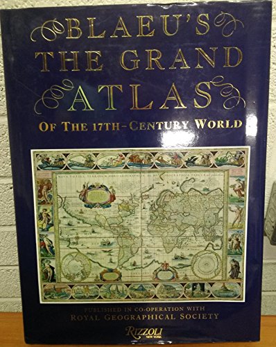
Blaeu's The Grand Atlas Of The 17th Century World
Vendeur : Magers and Quinn Booksellers, Minneapolis, MN, Etats-Unis
Évaluation du vendeur 5 sur 5 étoiles

EUR 10,52
Autre deviseEUR 3,40 expédition vers Etats-UnisQuantité disponible : 1 disponible(s)
Ajouter au panierhardcover. Etat : Very Good. May have light to moderate shelf wear and/or a remainder mark. Complete. Clean pages.
-
Blaeu's The Grand Atlas of the 17th-Century World
Edité par Rizzoli / Royal Geographic Society, 1991
ISBN 10 : 0847813002 ISBN 13 : 9780847813001
Langue: anglais
Vendeur : Brazos Bend Books, Houston, TX, Etats-Unis
Membre d'association : IOBA
Évaluation du vendeur 5 sur 5 étoiles
EUR 28,09
Autre deviseEUR 4,26 expédition vers Etats-UnisQuantité disponible : 1 disponible(s)
Ajouter au panierHardcover. Etat : Near Fine. Etat de la jaquette : Very Good. Near Fine in a Very Good dust jacket. Jacket a bit rubbed and with a three and a half inch crease on rear panel.
-
Blaeu's The Grand Atlas of the 17th-Century World
Vendeur : Abacus Bookshop, Pittsford, NY, Etats-Unis
Évaluation du vendeur 5 sur 5 étoiles
Edition originale
EUR 30,72
Autre deviseEUR 3,41 expédition vers Etats-UnisQuantité disponible : 1 disponible(s)
Ajouter au panierhardcover. Profusely illustrated (illustrateur). 1st. Folio, 224 pp., Introduction, selection and caption notes by John Goss; foreword by Peter Clark. Fine copy in nearly fine dust jacket.
-
Le Royaume de France, Atlas du XVIIe de Johannes Blaeu
Edité par Malherbe, 1987
Vendeur : Le Temps Retrouvé, FIGEAC, France
Évaluation du vendeur 3 sur 5 étoiles

EUR 15
Autre deviseEUR 9 expédition depuis France vers Etats-UnisQuantité disponible : 1 disponible(s)
Ajouter au panierCouverture rigide. Etat : Bon. Réimpression contemporaine du plus célčbre des atlas du 17e sičcle réalisé par le cartographe néerlandais Johannes Blaeu (1596 ŕ 1673) avec les cartes des régions de France. Il fut publié pour la premičre fois entre 1662 et 1665. Publié par Malherbe en 1987 , broché avec une couverture rigide en trčs bon état, format 32,5x26,5x2 cm , 287 pages.
-

Blaeu's The Grand Atlas of the Seventeenth Century World
Edité par Studio Editons for The Royal Geographic Society, London, 1990
ISBN 10 : 1851704000 ISBN 13 : 9781851704002
Langue: anglais
Vendeur : Your Book Soon, Stroud, GLOS, Royaume-Uni
Évaluation du vendeur 5 sur 5 étoiles
Edition originale
EUR 21,12
Autre deviseEUR 19,42 expédition depuis Royaume-Uni vers Etats-UnisQuantité disponible : 1 disponible(s)
Ajouter au panierHardcover. Etat : Near Fine. Etat de la jaquette : Very Good. 1st Edition. 224 pp colour maps and illustrations throughout, blue cloth with gilt title to spine. Book clean and sound, a little shelf wear to dust wrapper. Over 2.6 Kg will need extra postage outside UK.
-

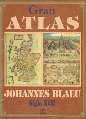
GRAN ATLAS
Vendeur : Urbano Librería Infinita, Granada, GR, Espagne
Évaluation du vendeur 5 sur 5 étoiles
EUR 14,40
Autre deviseEUR 50 expédition depuis Espagne vers Etats-UnisQuantité disponible : 1 disponible(s)
Ajouter au panierCartoné. Etat : Bueno. Etat de la jaquette : Bueno. Libros.
-
GRAN ATLAS. SIGLO XVII
Vendeur : Domiduca Libreros, Alcalá de Henares, M, Espagne
Évaluation du vendeur 5 sur 5 étoiles
Edition originale
EUR 60
Autre deviseEUR 24,50 expédition depuis Espagne vers Etats-UnisQuantité disponible : 1 disponible(s)
Ajouter au panierCartoné con sobrecubierta. Etat : Como Nuevo. Primera edición FACSÍMIL. Muy ilustrado. 223 páginas.
-

Gran atlas de Johannes Blaeu : el mundo en el siglo diecisiete
Vendeur : Almacen de los Libros Olvidados, Barakaldo, Espagne
Évaluation du vendeur 5 sur 5 étoiles
EUR 38,50
Autre deviseEUR 60 expédition depuis Espagne vers Etats-UnisQuantité disponible : 1 disponible(s)
Ajouter au panierTapa dura. Etat : 2Ş Mano. , . Ilustrado con mapas de la época. . . . Tapa dura, 224 p. ; 38x28 cm.
-
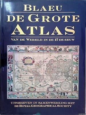
De grote atlas van de wereld in den 17de eeuw
Edité par Lisse, Zuid Boekproducties, 1992
ISBN 10 : 9062487386 ISBN 13 : 9789062487387
Langue: néerlandais
EUR 16,50
Autre deviseEUR 50 expédition depuis Pays-Bas vers Etats-UnisQuantité disponible : 1 disponible(s)
Ajouter au panierEtat : Good. Originele hardcover met goudopdruk op rug, stofomslag, veel grote afbeeldingen in kleur.
-
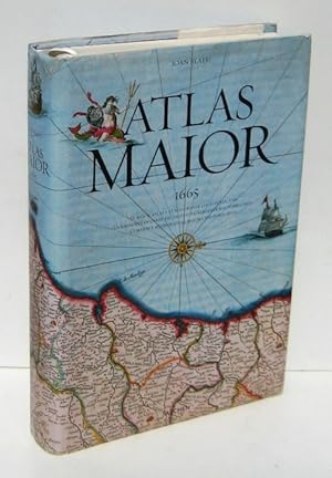
ATLAS MAIOR (1665) Geographia, qae est Cosmographiae blavianae pars prima, qua orbis terrae (.)
Vendeur : Ducable Libros, Mataró, B, Espagne
Évaluation du vendeur 5 sur 5 étoiles
EUR 107,80
Autre deviseEUR 80 expédition depuis Espagne vers Etats-UnisQuantité disponible : 1 disponible(s)
Ajouter au panier. 593 pp. 44,5x29,5 cm. Magnífica edición en papel cartulina de calidad; ilustrada con espectaculares imágenes en color, casi todas a toda y doble pág. 7 hojas desplegables, 4 cuádruples y 3 dobles; conteniendo mapas de todo el mundo, detalles y otras otras ilustraciones, y algunas fotos. (textos en espańol, italiano y portugués) (cosido un poco abierto en algún pliego, 1 lámina reparada) (hasta 8 kilos con carton) GEOGRAFIA ATLAS HISTORIA CARTOGRAFIA MAPAS FACSIMIL 86176 LL-B9 Buen estado general, sobrecubiertra con leves roces y rasgaduras reparadas en bordes Cartone ilustrado, con sobrecubierta Y cinta guía.
-
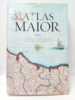
Atlas Maior (1665) / Introducción y textos de Peter van der Krogt; A partir de la copia conservada en la Österreichische Nationalbibliothek, Viena; Con una selección de textos originales de Joan Blaeu; Dirigido y producido por Benedikt Taschen
Vendeur : Librería Miguel Miranda, Lope de Vega n.ş XIX, Madrid, M, Espagne
Membre d'association : AILA ILAB
Évaluation du vendeur 4 sur 5 étoiles

Carte
EUR 200
Autre deviseEUR 14,95 expédition depuis Espagne vers Etats-UnisQuantité disponible : 1 disponible(s)
Ajouter au panierEtat : Good / Bien. Köln (pero imp. en Italia): Taschen, cop. 2005.- 593 p.: Profusión de ilustraciones, mapas y láminas a todo color, varios plegados; Folio Imperial (45 x 31 cm); Fina impresión sobre grueso papel couché; Edición trilingüe en espańol, italiano y portugués; Encuadernación en Cartoné Ed. con camisa.- CONTIENE: Prefacio de Joan Blaeu de 1665; Introducción a la Geografía de Joan Blaeu; Et Atlas Maior de Joan Blaeu, introducción de Peter van der Krogt; Catálogo de mapas, con una se textos originales de Joan Blaeu; Apéndice. Libro en espańol GEOGRAFÍA, GUÍAS Y ATLAS DEL EXTRANJERO.
-

GRAN ATLAS de Johannes Blaeu SIGLO XVII
Vendeur : Ducable Libros, Mataró, B, Espagne
Évaluation du vendeur 5 sur 5 étoiles
EUR 29,70
Autre deviseEUR 80 expédition depuis Espagne vers Etats-UnisQuantité disponible : 1 disponible(s)
Ajouter au panierEtat : Muy buen estado. . 223 pp. 39x29 cm. edición a todo color en papel de calidad. Contenido: 16 pp. de Introducción seguidas de la colección de mapas de todo el mundo a doble pág. y con comentario al magen. . . GEOGRAFIA ATLAS HISTORIA CARTOGRAFIA MAPAS 60062 VO-231 Cartone plastificado y con sobrecubierta.
-
![Image du vendeur pour Namur / Namür / Hennegau. - Historische Kupferstichkarte. Comitatuum Hannoniae et Namurci descriptio. [Grafschaft Hennegau, frz: Hainaut in Belgien nebst angrenzender Gebiete. Wahrscheinlich aus: van der Krogt, Koeman's Atlantes Neerlandici, Vol. I.] mis en vente par Antiquariat Carl Wegner](https://pictures.abebooks.com/inventory/md/md14339280276.jpg)
Namur / Namür / Hennegau. - Historische Kupferstichkarte. Comitatuum Hannoniae et Namurci descriptio. [Grafschaft Hennegau, frz: Hainaut in Belgien nebst angrenzender Gebiete. Wahrscheinlich aus: van der Krogt, Koeman's Atlantes Neerlandici, Vol. I.]
Edité par [Johannes Janssonius (Jansson). Amsterdam, 1636.], 1636
Langue: latin
Vendeur : Antiquariat Carl Wegner, Berlin, B, Allemagne
Membre d'association : GIAQ
Évaluation du vendeur 5 sur 5 étoiles
Edition originale
EUR 57
Autre deviseEUR 9 expédition depuis Allemagne vers Etats-UnisQuantité disponible : 1 disponible(s)
Ajouter au panierSoftcover. Kartengröße: 49 x 51,5 cm. Oben links einEngel die Meilenanzeige haltend, unten rechts die Titelkartusche von zwei Wappen flankiert: rechts vier Löwen unter einer Krone (das Wappen von Hennegau), rechts ein Löwe unter einer Krone (das Wappen Belgiens). Im unteren Randbereich ein 2 cm langer Einriss, der bis in die Karte hineinreicht, sonst im Randbereich kleinere Fehlstellen und Einrisse. Der Kartenbereich im unteren rechten Eck nur in der Randung mit Längen- und Breitengraden etwas abgerieben. Weiterhin auf der Karte: Wallonien, Mons, Teile von Brabant begrenzt durch Oudenaarde, Huy und Cambrai, oben links Flandern. - Versand als Rolle zu 5.-Euro. - -- Bitte Portokosten außerhalb EU erfragen! / Please ask for postage costs outside EU! / S ' il vous plait demander des frais de port en dehors de l ' UE! // Bitte beachten Sie auch unsere Fotos! / Please also note our photos! / Veuillez noter nos photos -- Ein gutes Buch geleitet Sie durch goldenen Herbstsonnenschein und stürmische Tage. -- Wir kaufen Ihre werthaltigen Bücher! Fe2Klavier.
-
Gran Atlas Johannes Blaeu Siglo XVII
Vendeur : El Pergamí Vell (Sant Celoni), Sant Celoni, B, Espagne
Évaluation du vendeur 5 sur 5 étoiles
Edition originale
EUR 45
Autre deviseEUR 30 expédition depuis Espagne vers Etats-UnisQuantité disponible : 1 disponible(s)
Ajouter au panierTapa dura con sobrecubierta /. Etat : Bien. Etat de la jaquette : Aceptable. 1Ş Edición. Roces y pequeńos desperfectos por el uso. Reproducción de la obra cartográfica más importante del S. XVII, presenta una selección de 100 mapas extraída de los más de 600 que contiene el original. La belleza de las láminas y la sensación de tiempo detenido ante la concepción que se tenía del mundo en el 1600, son un regalo para el aficionado a la historia, la geografía o el arte.
-
Gran atlas, siglo XVII
Date d'édition : 1999
Vendeur : Libreria Anticuaria Camino de Santiago, León - Madrid, LE, Espagne
Évaluation du vendeur 4 sur 5 étoiles
EUR 22
Autre deviseEUR 49,10 expédition depuis Espagne vers Etats-UnisQuantité disponible : 1 disponible(s)
Ajouter au panierEtat : Bueno. 21338 Blaeu, Johannes 1999 Libsa, Madrid, 1999. Cartoné edit. con sobrecub., multitud de mapas a color. 223 pp. Gran formato Cartografía,Atlas.
-
Corpus Juris Civilis
Edité par Amstelodami, : Sumptibus Societatis, ex typographia P. & I. Blaev, prostant apud Waesbergios, Boom, ŕ Someren & Goethals, 1700
Vendeur : Joseph Burridge Books, Dagenham, Royaume-Uni
Évaluation du vendeur 5 sur 5 étoiles
Edition originale
EUR 117,99
Autre deviseEUR 28,64 expédition depuis Royaume-Uni vers Etats-UnisQuantité disponible : 1 disponible(s)
Ajouter au panierHardcover. Etat : Fair. 1st Edition. 1st thus. 'Editio nova, prioribus correctior'. 2 volumes in 1 book, 1037 & 820 pages in Latin : 21 cm. worn leather covers & spine, occasional contemporary notes in pen, foxing to endpapers. internally Good. 17th century legal commentary which remained the basis for dealing with Roman law well into the 19th century.
-

De Grote Atlas van de Wereld in de 17de eeuw. uitgegeven in samenwerking met de Royal Geographical Society
Edité par Lisse, Rebo Productions, Robas, 1992
ISBN 10 : 9062487386 ISBN 13 : 9789062487387
Langue: néerlandais
Vendeur : Antiquariat Biebusch, Lilienthal, Allemagne
Membre d'association : GIAQ
Évaluation du vendeur 5 sur 5 étoiles
EUR 42
Autre deviseEUR 105 expédition depuis Allemagne vers Etats-UnisQuantité disponible : 1 disponible(s)
Ajouter au panierPappe. Etat : Gut. 224 S., 39 cm Zustand: Schutzumschlag berieben mit leichten Randläsionen, Leinen am unteren Kapital durchgerieben, Kopfschnit staubfleckig, Stehkante angestaubt, Namenseintrag --- Inhalt: Text in Holländisch. 100 farbige Karten aus dem 17. Jahrhundert ROS1-1 ISBN: 9062487386 Sprache: Niederländisch Gewicht in Gramm: 2600.
-

DER ATLAS DES PRINZEN EUGEN. - Originalgetreue Faksimile-Reproduktionen aus dem 'ATLAS BLAEU - Van der Hem'(Amsterdam 1662-1678) der Österreichischen Nationalbibliothek, Band 1: SCHWEIZER STÄDTE- UND LANDSCHAFTSBILDER IN ILLUMINIERTEN KUPFERSTICHEN DES 17. JAHRHUNDERTS. - 35 Ansichten und 8 Kartenblätter; mit einem wissenschaftlichen Kommentar von Robert Wagner. [Helvetia, quae est Europae Liber XV.]
Edité par Graz, Akademische Druck- und Verlagsanstalt / ADEVA, 1979., 1979
Vendeur : C O - L I B R I , Bremen - Berlin ; Deutschland / Germany ., Berlin, Allemagne
Évaluation du vendeur 5 sur 5 étoiles
EUR 235
Autre deviseEUR 26,13 expédition depuis Allemagne vers Etats-UnisQuantité disponible : 1 disponible(s)
Ajouter au panier67 (1) Seiten Text, 43 einseitig bedruckte tls. doppelblattgroße Farbtafeln mit zwischenliegenden Seidenschutzblättern; alles auf kräftigem hochwertig strukturiertem Papier. - Schwerer, reich vergoldeter weißer Original-Ledereinband - wohl - auf Holzdeckeln und über 8 erhabene Bünde mit goldgeprägtem Rückentitel; imperial-Folio (ca. 59,5 x 40 x 4 cm; ca. 6,2 kg.). *** [Letztmalig verlängerter, nochmals erweiterter SOMMER-SCHLUSS-VERKAUF (bis Montag, den 06.10.2025) / Ultimately extended SUMMER-END-SALE (until Monday, October 6th, 2025): um fast 50% REDUZIERTER PREIS / PRICE-REDUCTION of almost 50%; ursprünglicher Preis / originally EUR 465,-] --- 1. AUFLAGE, ÜBERGROSSFORMATIGE BIBLIOPHIL GEBUNDENE AUSGABE; Nr. CCXXXII (#232) von 1.000 Exemplaren der Gesamtauflage (noch mit beiliegendem signierten Qualitätsprüfzettel). - Vorderdeckel am Rand etwas stockfleckig-, Hinterdeckel nur am Rand der unteren Innenkante; Vorderdeckel auch mit kleiner Bereibung und kleinem oberflächlichen Lederabrieb (ca. 5x5 mm); innen tadellos und mit allen Seidenschutzblättern. --- DER TEXTTEIL ENTHÄLT DIE KAPITEL 'Der Atlas des Prinzen Eugen von Savoyen, oder >Atlas Blaeu - Van der Hem<.'; 'Der Initiator: Laurens Van der Hem.'; 'Spiritus Rector: Joan Blaeu.'; 'Der Illuminator: Dirck Jansz. van Santen.'; 'Der Bibliophile: Prinz Eugen von Savoyen.'; 'Die Städte- und Landschaftsbilder: Matthäus Merian und seine Grosse Topographie.'; 'Die Schweiz im Atlas des Prinzen Eugen von Savoyen.'; 'Übersicht aller Bände des Atlas . . .'; 'Literatur.'; 'Die Tafeln: Verzeichnis der Tafeln.'; 'Die illuminierten Kupferstiche aus Band 13 (Schweiz) im Atlas . . . / Illuminierte Schweizer Kupferstiche aus anderen Bänden des Atlas . . .'; DIE MONTIERTEN FARBTAFELN AUF HALBMATTEM KUNSTDRUCKPAPIER ZEIGEN die 'Schweiz.'(Johannes Janssonius); das 'Rheintal oberhalb Chur, Graubünden.'(Caspar Merian)*; den 'Rheinfall bei Schaffhausen.'(Matthäus Merian)**; 'Rhein bei Kadelburg, Aargau.'(**); 'Grüningen, Zürich.'(Hans Heinrich Thomann/**); 'Regensberg, Zürich.'(Johann Jacob Ziegler/**); 'Zürichgau und Basel'(Gerard Mercator/Willem Jansz. Blaeu)***; 'Zürich.'(Hans Caspar Nüscheler/**); 'Breitenlandenberg, Zürich.'(*); 'Einsiedeln, Schwyz.'(**); 'Leuk, Wallis.'(*); 'Sempach, Luzern.'(**); 'Baden, Aargau.'(**); 'Wiflisburgergau.'(***); 'Grindelwaldgletscher, Bern.'(Josef Plepp/**)****; 'Paß Pierre Pertuis.'(****); 'Lenzburg, Aargau.'(****); 'Neuenburg/Neuchâtel.'(**); 'Aargau.'(***); 'Vierwaldstätter See.'(Johann Leopold Cysat/*); 'Luzern.'(Martin Martini/**); 'Altdorf, Uri.'(**); 'Thun.'(**); 'Schwyz.'(*); 'Bad Pfäfers, St. Gallen.'(**); 'Unterwalden.'(**); 'Basel.'(**); 'Rheinbrücke und Münster in Basel.'(**); 'Münchenstein, Basel Land.'(**); 'Basel und Umgebung.'(Joan Blaeu); 'Graubünden.'(Fortunat Sprecher. . . und Philipp Clüver/W.J. Blaeu); 'Chur, Graubünden.'(**); 'Wallis.'(Pierre du Val d'Abbéville); 'Saint-Maurice/[St. Moritz], Wallis.'(*); 'Brig und Naters, Wallis.'(*); 'Lugano, Tessin.'(**); 'Bellinzona, Tessin.'(**); 'Engelberg, Unterwalden ob dem Wald.'(*); 'Landschaft um Bad Pfäfers, St. Gallen.'(*); 'Visp, Wallis.'(*); 'Genfer See.'(Jacques Goulart/W. J. Blaeu); 'Genf/Genčve.'(Jean Poinssart); 'Tarasp, Graubünden.'(*).
-
![Image du vendeur pour Paraguay, O Prov. De Rio de la Plata cum regionibus adiacentibus Tucuman et Sta. Cruz de la Sierra [Map, mapa de Paraguay] mis en vente par Bolivar Old Prints Anticuario](https://pictures.abebooks.com/inventory/md/md31793407533.jpg)
Paraguay, O Prov. De Rio de la Plata cum regionibus adiacentibus Tucuman et Sta. Cruz de la Sierra [Map, mapa de Paraguay]
Edité par Ámsterdam, 1630
Vendeur : Bolivar Old Prints Anticuario, Barcelona, B, Espagne
Membre d'association : AILA ILAB
Évaluation du vendeur 4 sur 5 étoiles
Carte
EUR 320
Autre deviseEUR 25 expédition depuis Espagne vers Etats-UnisQuantité disponible : 1 disponible(s)
Ajouter au panierSin Encuadernar. Etat : Bueno. c. 1630. Decorativo mapa original de Paraguay, el río de la Plata y la región circundante. Destacan al centro los cursos del río de la Plata, el río Paraguay y el río Paraná, mientras que a la izquierda dominan la cordillera de los Andes (representada de forma pictográfica) y el lago Titicaca. Identifica importantes ciudades como Rio de Janeiro, Sao Paolo, Buenos Aires, Córdoba, Santiago, Mendoza, Potosí y Cusco. El trópico de Capricornio divide el mapa longitudinalmente y contiene algunos de los elementos más característicos de la época dorada cartografía holandesa, como un navío, un monstruo marino y una ornamentada rosa de los vientos coronada por una flor de lis. Willem Janszoon Blaeu (1571-1638) fue un prominente editor y geógrafo holandés. Estudió con el famoso astrónomo danés Tycho Brahe y estableció una tienda de globos, mapas e instrumentos de astronomía en Ámsterdam. En 1635 publicó su famosísimo atlas Theatrum Orbis Terrarum, sive, Atlas novus. Tres ańos más tarde, Blaeu murió y heredó su firma editorial a sus hijos Cornelius y Johannes, con quienes siguió prosperando. Este último fue responsable del Atlas Major que fue publicado en dos volúmenes en 1662 y contuvo seiscientos mapas. Esta obra no fue tan exacta y actualizada como a su autor le hubiera gustado, pero esta deficiencia fue superada por el finísimo grabado y el color, al punto de ser considerada como una de las mejores en su tipo. En 1672 un incendio destruyó la imprenta de Blaeu y un ańo después él murió. Las placas y mapas que sobrevivieron al incendio se dispersaron, pasando a manos de F. de Wit, Schenk y Valck. 39 x 49 cm. FRA. Very Good, Muy bueno.
-
Seste Stuck der Aerdrycks-Beschryving, welck Vervat Vranckryck.
Edité par Amsterdam: Johannes Blaeu, [ca. 1662-1665]. 1662, 1665
Vendeur : JF LETENNEUR LIVRES RARES, Saint Briac sur mer, France
Membre d'association : ILAB
Évaluation du vendeur 5 sur 5 étoiles
EUR 5 500
Autre deviseEUR 9 expédition depuis France vers Etats-UnisQuantité disponible : 1 disponible(s)
Ajouter au panier1 vol. in-plano (555 x 355 mm) de : 1 titre gravé en coloris d'époque ; [5] pp ; XXXII ; 57 ff. ; [1] p. (table) ; 66 cartes gravées sur double page en coloris d'époque (dont une dépliante). (Carte de « Burgundiae » [22] avec déchirure le long de la pliure, carte dépliante « Imperii Caroli Magni » avec déchirures le long des plis, légčres mouillures marginales ŕ la fin, quelques tâches marginales, quelques coins restaurés). Plein veau d'époque, dos ŕ nerfs orné et titré, double filet doré et frises encadrant les plats, motifs dorés estampés ŕ froid aux coins et au centre des plats, roulette dorée sur les coupes. (dos réparé au niveau de la jointure supérieure et des extrémités du dos). Édition néerlandaise de cet atlas de France dű ŕ Johannes Blaeu (1596-1673), cartographe, imprimeur-libraire et éditeur néerlandais. L'ouvrage est principalement composé des cartes du sixičme volume sur la France du chef-d'uvre de Blaeu, l'Atlas Major. Il est bien complet de ses 66 gravures sur double-page en coloris d'époque accompagnées des descriptions en néerlandais. Né ŕ Alkmaar, Johannes Blaeu reprend les fonctions de son pčre Willem Blaeu en tant que cartographe officiel de la Compagnie néerlandaise des Indes orientales. Son fils, Joan Blaeu, lui succčde, dans les męmes fonctions, de 1672 ŕ 1705. La premičre carte représente le Royaume de France et les 62 suivantes sont consacrées ŕ ses régions. En fin d'atlas se trouvent une carte de l'Europe et deux cartes de la Gaule historique sous l'Empire Romain. L'ouvrage est introduit par un joli titre gravé en coloris d'époque, dans le style architectural classique de la Renaissance et rappelant la section sur la France du Theatrum Orbis Terrarum. Le titre est flanqué de deux piliers coiffés d'une structure en dôme supportant les armoiries royales du royaume de France aprčs la conclusion des guerres de religion françaises. La devise d'Henri IV, "Duo Protegit Unus" ("Un protčge deux" - en d'autres termes, le roi protčge ŕ la fois la France et la Navarre), figure en haut. Bel exemplaire. 1 vol. in-plano (555 x 355 mm) with : 1 engraved title in contemporary colors ; [5] pp ; XXXII ; 57 ff. ; [1] p. (table) ; 66 engraved double-page maps in contemporary colors (one folding). (Map of "Burgundiae" [22] with tear along fold, fold-out map "Imperii Caroli Magni" with tears along folds, slight marginal wetness at end, a few marginal stains, a few corners restored). Contemporary full calf, spine ribbed, decorated and titled, double gilt fillet and friezes framing the boards, cold-stamped gilt motifs at the corners and center of the boards, gilt roulette on the edges (spine repaired at upper joint and spine ends). Dutch edition of this atlas of France by Johannes Blaeu (1596-1673), Dutch cartographer, printer, bookseller and publisher. Born in Alkmaar, he took over from his father Willem Blaeu as official cartographer to the Dutch East India Company. His son, Joan Blaeu, succeeded him in the same role from 1672 to 1705. The work is mainly composed of maps from the sixth volume of Blaeu's masterpiece, the Atlas Major, covering France. It is complete with 66 double-page engravings in period colors, accompanied by descriptions in Dutch. The first map represents the Kingdom of France, and the following 62 are devoted to its regions. At the end of the atlas are a map of Europe and two maps of historic Gaul under the Roman Empire. The work is introduced by an attractive title engraved in period colors, in the classical Renaissance architectural style, reminiscent of the section on France in Theatrum Orbis Terrarum. The title is flanked by two pillars topped by a domed structure supporting the royal coat of arms of the kingdom of France after the conclusion of the French Wars of Religion. Henri IV's motto, "Duo Protegit Unus" ("One protects two" - in other words, the king protects both France and Navarre), appears at the top.
-
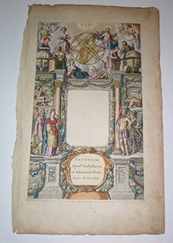
Title page for THEATRUM ORBIS TERRARUM, Sive ATLAS NOVUS; in quo TABULAE et Descriptiones omnium Regionum, Editae a Guiljel: et Joanne Blaeu. First edition.
Edité par Amsterdam: Willem Blaeu & Johannes Blaeu 1635, 1635
Vendeur : Wittenborn Art Books, San Francisco, CA, Etats-Unis
Évaluation du vendeur 4 sur 5 étoiles
Art / Affiche / Gravure
EUR 1 316,53
Autre deviseEUR 8,52 expédition vers Etats-UnisQuantité disponible : 1 disponible(s)
Ajouter au panierEtat : Good. Folio. 49.8 x 29.7 cm. Old laid paper with arrow above H watermark. Possibly contemporary coloring. Remainder of paper binding hinge. Willem Blaeu (1571-1638) et Johannes Blaeu (1596-1673)BELLE PAGE DE TITRE D'ATLAS sans texte, gravée en noir rehaussée d'aquarelle, avec partie de texte en latin dans le médaillon inférieur, Amsterdam, 1635.(restauration en bordure)50 x 30,5 cmExpertise by Jean-François BétisF-40360 Donzacq.
-
Novum ac magnum theatrum urbium Belgicae Regiae.
Edité par Amsterdam: Johannes Blaeu, 1649., 1649
Vendeur : Arader Galleries - AraderNYC, New York, NY, Etats-Unis
Évaluation du vendeur 5 sur 5 étoiles
Edition originale
EUR 24 575,23
Autre deviseGratuit expédition vers Etats-UnisQuantité disponible : 1 disponible(s)
Ajouter au panierVolume II only of 2 volumes. Folio (21 x 14 inches). Latin text, with both Dutch and French Privilege leaves, letterpress title pasted within engraved architectural border, 9 divisional half-titles and 93 (of 95, lacking plates 94 and 95: Gulich and Linga, both full-pages, not double-page, engravings, water-staining at upper inner margin of first leaves and affecting several map images, repaired worm-holes on lower margins of a few leaves, some leaves browned). Contemporary Dutch gilt panelled vellum (stained). Third edition of volume II, the towns belonging to Spain, of BLAEU'S GREAT WORK ON THE TOWN'S OF THE NETHERLANDS. "Of all the Blaeu atlases, the townbooks of the Netherlands are held in the highest esteem in the Netherlands. This is partly due to the fact that their composition is linked up with the struggle for independence from Spain of the Dutch Republic in the 17th-Century. Bound up, by sentiment, with the most dramatic and heroic period of the shaping of the Dutch State it shows the proud and industrious cities of the North in their full splendour. Towards the end of the battle with Spain, Joan Blaeu planned his town books which were to contain ca. 220 maps, evenly distributed over two volumes: the towns of the Republic in Volume I, the towns belonging to Spain in Volume II. In the planning stage of the atlas, some years before 1648, while the text had been printed and also most of the plates, Joan Blaeu could not know how the Peace treaty would turn out. In the last decades of the war, several towns and fortresses in the south had been or were besieged by the army of the Republic and Blaeu had to take a decision as to inclusion of these disputed towns into the two volumes of his atlas. The very first edition of his town atlas reflects the situation during the last years of the war: 26 maps of towns and fortresses are incorporated in the "Spanish" volume, but had to be transferred to the "Republic" volume in a second edition. Five maps of the "Republic" had to be transferred to the "Spanish" side. Consequently, apart from the very rare first edition, the volumes I and II are uneven in the number of maps, the first volume being the larger. At the end of the Index of the first edition, printed in 1649 after the Treaty of Westphalia, Joan Blaeu [gives a] notice to the reader" explaining the arrangement of the maps" (Koeman I, page 295). The Blaeu family firm was founded by Willem Janzoon Blaeu (1571-1638) in 1596. He was eventually joined by his sons, Cornelius (1616-1648) and Joan (1596-1673). The firm became the most productive cartographic establishment in the Netherlands until it was destroyed by fire in 1672. The elder Blaeu initiated the great series of atlases that culminated in the "Atlas Maior", in which Joannes Blaeu incorporated much of the geographical knowledge bequeathed him by his father. Koeman 1, BL 67. Catalogued by Kate Hunter.
-
EUR 22 000
Autre deviseEUR 24,75 expédition depuis Belgique vers Etats-UnisQuantité disponible : 1 disponible(s)
Ajouter au panier66 kaarten ( één scheur van ongeveer 10 cm en vouw in een kaart van Bourgondië. Lichte marginale watervlek op de titelbladzijde en op de eerste ff. Zesde deel van Blaeu's meesterwerk, de Atlas Maior. Nederlandstalige uitgave met 66 gravures op dubbele paginas . 66 pl. (1 tear +/- 10 cm and fold in 1 Burgundy map, light marginal waterstain on title and 1st ff.). Sixth part of Blaeu's superb "Atlas Maior", the finest and most comprehensive baroque atlas of that time. Dutch edition, complete with 66 double-paged engraved maps (b/w, 1 folding). Ref. Koeman 1, Bl. 57. 1 vol volumes. Lichte gebruiksporen, klein wormgat en stukje ontbrekend leder. Sl rubbed, small wormhole and piece of leather lacking. Very good copy. Professioneel gerestaureerde band in kalfsleder, vergulde rug met groene en zwarte titelvignetten. Finely restaured quarter calf , gilt spine with green and black title labels, blindstamped front cover with title and editor.
-
Theatrum Civitatum et Admirandorum Italiae. Amsterdam: Johannes Blaeu, 1663 - Novum Italiae Theatrum,. continens Regna Neapolis et Siciliae.
Edité par The Hague: Rutgeri Christophori Alberts, 1724., 1724
Vendeur : Arader Galleries - AraderNYC, New York, NY, Etats-Unis
Évaluation du vendeur 5 sur 5 étoiles
Edition originale
EUR 140 429,88
Autre deviseGratuit expédition vers Etats-UnisQuantité disponible : 1 disponible(s)
Ajouter au panierTogether 3 volumes. Folio (22 x 14 inches; 20 6/8 x 13 inches). First two volumes: Text in Latin, mounted on guards throughout. General title-pages in Van der Krogt's variants 1B and 2B, half-titles, privilege leaf as found in variant B only. Additional engraved title-page to volume II (only, without engraved title-page to volume I, lightly browned and edges a bit frayed), 119 engraved plates of views, plans and monuments, comprising: 8 folding double-page plates, 76 double-page plates, 2 plates on one double-page, 25 full-page plates and 8 illustrations in the text, mounted on guards throughout, including plate 11 Bononia complete with the folding extension (the folding plate of Frascati a little creased at fold and with long tear affecting the image and another marginal tear to crease fold, but without loss, occasional light spotting and browning, heavier to about 11 plates, light marginal dampstaining throughout volume II, heavier and affecting the images in a few central gatherings). Contemporary Dutch gilt panelled vellum, all edges gilt (extremities rubbed, spines worn with considerable loss, lacking ties). Third volume: Letterpress title-page printed in red and black. Additional engraved title-page frontispiece, additional double-page engraved map of Italy by Sanson, published by Covens and Mortier, 2 double-page and folding, 26 double-page, and 11 full-pages of views in and around Naples and Sicily (some browning). Contemporary speckled calf, gilt (some surface tears, hinges a bit weak). Provenance: evidence of stamps removed from front pastedown and engraved title-page in volume II; with the large engraved armorial bookplate of John Holland, Heraldry Artist, BY WILLIAM HOGARTH, on the front paste-down of volume III. FIRST EDITION OF THE FIRST TWO VOLUMES OF BLAEU'S CELEBRATED BOOKS OF TOWNS AND MONUMENTS OF ITALY, accompanied and completed by the later 1724 edition of the third volume containing spectacular views of Naples and Sicily. The first two volumes are the original Latin edition, with volume I as Van der Krogt's variant C (no priority assigned) containing 6 extra plates. The second volume is devoted to Ancient Rome, with splendid views of circuses, theatres and amphitheatres. A large portion of this latter volume dealing with Egyptian obelisks is based on the works of Athanasius Kircher (1602-1680). These volumes are VERY RARE, only 'About 75 copies (single volumes included) are known.' The Blaeu family firm was founded by Willem Janzoon Blaeu (1571-1638) in 1596. He was eventually joined by his sons, Cornelius (1616-1648) and Joan (1596-1673). The firm became the most productive cartographic establishment in the Netherlands until it was destroyed by fire in 1672. The elder Blaeu initiated the great series of atlases that culminated in the "Atlas Maior", in which Joannes Blaeu incorporated much of the geographical knowledge bequeathed him by his father. With the engraved armorial bookplate of John Holland, by William Hogarth (1697-1764) who as one of the great exponents of cartoon, caricature and moralizing painting, was the originator of the celebrated "A Rake's Progress" (1734). He is known to have engraved three ex-libris (bookplates) of which the one for John Holland, as here, heraldry artist, is the most important. This is the rare first state of the plate, of which the shield was re-engraved to reduce the lion rampant's size and that of the fleur-de-lys. The second state is illustrated in the catalogue Ex-libris o el arte de identificar sus libros, Bogotá, 1988. Though more formal than much of Hogarth's work, this print shows the sureness of line and perfection of composition characteristic of his art. Previously in the Summers collection. 2i/3. William Hogarth (GB, 1697-1764), JOHN HOLLAND, C3, 107 x 103, c.1735. F15102. Viz. ELJ Vol. iii p. 1, BNL #55; Van der Krogt 43:211.1L and 43:211.2L; Koeman Bl 97. Catalogued by Kate Hunter.
-
GRAN ATLAS JOHANNES BLAEU SIGLO XVII -CON REPRODUCCIONES A COLOR DE MAPAS HISTORICOS-ILUSTRAC. A TODO COLOR
Edité par LIBSA -ROYALL GEOGRAPHICAL SOCIETY, 1991
Vendeur : CALLE 59 Libros, Tarancón, CU, Espagne
Évaluation du vendeur 5 sur 5 étoiles
EUR 70
Autre deviseEUR 25 expédition depuis Espagne vers Etats-UnisQuantité disponible : 1 disponible(s)
Ajouter au panierEtat : ESTADO MUY BUENO. TAPA BLANDA RUSTICA EDITORIAL.
-
GRAN ATLAS DE JOHANNES BLAEU: EL MUNDO EN EL SIGLO DIECISIETE
Vendeur : LIBRERIA ANTICUARIO BELLVER MADRID, MADRID, Espagne
Évaluation du vendeur 5 sur 5 étoiles
EUR 45
Autre deviseEUR 20 expédition depuis Espagne vers Etats-UnisQuantité disponible : 1 disponible(s)
Ajouter au panier1991, Editorial Libsa. Gran formato, 38x28 cm. 224 pág. Ilustrado con los mapas de la edición de 1662. Muy buen estado de conservación, con sobrecubierta original. pas. ATLAS MAPAS 14406.
-
Theatrum Orbis Terrarum. sive Atlas Novus. Pars Quarta [England & Wales]
Edité par Johannem Blaeu, Amsterdami, 1646
Langue: latin
Vendeur : Madoc Books (ABA-ILAB), Llandudno, CONWY, Royaume-Uni
Membre d'association : ABA ILAB IOBA PBFA
Évaluation du vendeur 5 sur 5 étoiles
EUR 7 079,30
Autre deviseEUR 34,37 expédition depuis Royaume-Uni vers Etats-UnisQuantité disponible : 1 disponible(s)
Ajouter au panierHardcover. Etat : Very Good. BLAEU Johannes & Guillaume (illustrateur). 2nd Edition. In contemporary Dutch full boxed vellum, retaining evidence of green linen ties, yapp edges, a few minor scuffs & marks, near contemporary faint manuscript title to spine. Internally, title leaf, [8], 460, [1], ie: engraved allegorical title & fifty eight engraved maps (counted in paginations & register, all folding except for the Isle of Man; Bedfordshire & Buckinghamshire both on the one sheet), all with contemporary hand colouring, 4 engraved vignettes in the text (half page, also hand-coloured & depicting henges, burial chambers & mausolea), mounted on guards throughout (evidence of skillful removal & replacement), heavily water stained throughout causing some 'bleeding' of old watercolour, some maps heavily toned, (497*311 mm). (Koeman Bl 44 (volume 1 pp. 178-80). Skelton 42; cf. Chubb LIX-LX.) Second edition in Latin of this 'very fine atlas of the English counties compiled, mainly from the maps of John Speed' (Chubb). A total of six volumes were published. The present volume, depicting England and Wales, first appeared in 1645 and was reissued in 1646.
-
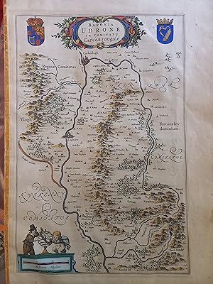
County Carlow, Ireland - "Baronia Udrone in Comitatu Cathersoughae Original Map 1645
Edité par Blaeu, Amsterdam, 1645
Vendeur : Temple Bar Bookshop, Dublin, DUB, Irlande
Évaluation du vendeur 4 sur 5 étoiles
Carte Edition originale
EUR 120
Autre deviseEUR 8 expédition depuis Irlande vers Etats-UnisQuantité disponible : 1 disponible(s)
Ajouter au panierNo Binding. Etat : Good. 1st Edition. Original Blaeu of map of County Carlow, image size approx 25 x 38cm. A good copy with some staining to the margins, the paper is a bit toned, hand coloured, possibly later.
-
GRAN ATLAS DEL SIGLO XVII
Vendeur : Librería Raimundo, CADIZ, CA, Espagne
Évaluation du vendeur 4 sur 5 étoiles
EUR 22,40
Autre deviseEUR 55 expédition depuis Espagne vers Etats-UnisQuantité disponible : 1 disponible(s)
Ajouter au panierMadrid, 2000. Editado por Libsa, Cartoné editorial. 39 x 28 cm. 223 pp. Contiene ilustraciones a color. Geografia.


![Image du vendeur pour Theatrum Orbis Terrarum. sive Atlas Novus. Pars Quarta [England & Wales] mis en vente par Madoc Books (ABA-ILAB)](https://pictures.abebooks.com/inventory/md/md31459419176.jpg)