Montant total (1 article articles) :
Destination de la commande :

monmonier mark second book skelton (1 résultats)
Commentaires
Passer aux résultats principaux de la recherche
Filtres de recherche
Type d'article
- Tous les types de produits
- Livres (1)
- Magazines & Périodiques (Aucun autre résultat ne correspond ŕ ces critčres)
- Bandes dessinées (Aucun autre résultat ne correspond ŕ ces critčres)
- Partitions de musique (Aucun autre résultat ne correspond ŕ ces critčres)
- Art, Affiches et Gravures (Aucun autre résultat ne correspond ŕ ces critčres)
- Photographies (Aucun autre résultat ne correspond ŕ ces critčres)
- Cartes (Aucun autre résultat ne correspond ŕ ces critčres)
- Manuscrits & Papiers anciens (Aucun autre résultat ne correspond ŕ ces critčres)
Etat En savoir plus
- Neuf (Aucun autre résultat ne correspond ŕ ces critčres)
- Comme neuf, Trčs bon ou Bon (1)
- Assez bon ou satisfaisant (Aucun autre résultat ne correspond ŕ ces critčres)
- Moyen ou mauvais (Aucun autre résultat ne correspond ŕ ces critčres)
- Conformément ŕ la description (Aucun autre résultat ne correspond ŕ ces critčres)
Reliure
- Toutes
- Couverture rigide (Aucun autre résultat ne correspond ŕ ces critčres)
- Couverture souple (1)
Particularités
- Ed. originale (1)
- Signé (Aucun autre résultat ne correspond ŕ ces critčres)
- Jaquette (Aucun autre résultat ne correspond ŕ ces critčres)
- Avec images (1)
- Sans impressions ŕ la demande (1)
Langue (1)
Prix
- Tous les prix
- Moins de EUR 20
- EUR 20 ŕ EUR 45 (Aucun autre résultat ne correspond ŕ ces critčres)
- Plus de EUR 45 (Aucun autre résultat ne correspond ŕ ces critčres)
Livraison gratuite
- Livraison gratuite ŕ destination de France (Aucun autre résultat ne correspond ŕ ces critčres)
Pays
Evaluation du vendeur
-
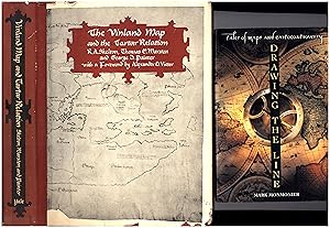
Drawing the Line / Tales of Maps and Cartocontroversy, AND A SECOND BOOK, The Vinland Map and the Tartar Relation
Edité par Henry Holt / Yale University Press, New York / New Haven and London, 1995
ISBN 10 : 0805025812 ISBN 13 : 9780805025811
Langue: anglais
Vendeur : Cat's Curiosities, Pahrump, NV, Etats-Unis
Évaluation du vendeur 5 sur 5 étoiles

Edition originale
EUR 7,90
Autre deviseEUR 36,64 expédition depuis Etats-Unis vers FranceQuantité disponible : 1 disponible(s)
Ajouter au panierSoft cover. Etat : As New. No Jacket. 1st Edition. Our first offering in this lot, "Drawing the Line," a trade paperback "First Edition -- 1995," deals with gerrymandering and continental drift, and offers a lengthy discussion of the controversy surrounding Yale's supposedly medieval "Vinland Map."' Symmetrical number line 3 5 7 9 10 8 6 4 2. The publishers contend they remove BOTH the numeral 1 and the "First Edition" statement from a second printing -- they're obviously wrong, and we conclude this is a first (trade paperback) printing. Geography. 368 pp. including Index. Reduced from $12. OUR SECOND OFFERING, here, is a "good" 1966 Yale University hardcover in a "good" dust jacket. "The Vinland Map and the Tartar Relation" states "Fourth printing April, 1966." (First was 1965.) A "good" quarto with a 5/8-inch rough spot to bottom corner of front board (possible kitten chew) in a "good" price-clipped dust jacket which is chipped to edges. Fold-out maps intact. Though they are later copies of much earlier originals, these maps (circa 1440) are cartographic evidence that distant lands -- including North America -- were known to at least some Europeans far earlier than imagined, the authors conclude. But controversy arose immediately upon publication of this effort -- issued essentially simultaneous with the announcement that alumnus Paul Mellon had purchased the map for a reported $300,000 for donation to the university -- and by 2019 specialists at Yale, where it is still held, declared that the latest scientific and historical research has established the "Vinland Map" to be a modern forgery. 291 pp. including index. The pair of books on related topics now reduced from $24.