
Montant total (1 article articles) :
Destination de la commande :

tirion isaak (262 rťsultats)
Commentaires
Passer aux rťsultats principaux de la recherche
Filtres de recherche
Type d'article
- Tous les types de produits
- Livres (96)
- Magazines & Pťriodiques (Aucun autre rťsultat ne correspond ŗ ces critŤres)
- Bandes dessinťes (Aucun autre rťsultat ne correspond ŗ ces critŤres)
- Partitions de musique (Aucun autre rťsultat ne correspond ŗ ces critŤres)
- Art, Affiches et Gravures (28)
- Photographies (Aucun autre rťsultat ne correspond ŗ ces critŤres)
- Cartes (138)
- Manuscrits & Papiers anciens (Aucun autre rťsultat ne correspond ŗ ces critŤres)
Etat En savoir plus
- Neuf (8)
- Comme neuf, TrŤs bon ou Bon (2)
- Assez bon ou satisfaisant (28)
- Moyen ou mauvais (Aucun autre rťsultat ne correspond ŗ ces critŤres)
- Conformťment ŗ la description (224)
Particularitťs
- Ed. originale (6)
- Signť (Aucun autre rťsultat ne correspond ŗ ces critŤres)
- Jaquette (1)
- Avec images (237)
- Sans impressions ŗ la demande (260)
Langue (4)
Livraison gratuite
Pays
Evaluation du vendeur
-
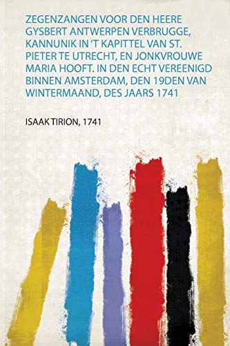
Zegenzangen Voor Den Heere Gysbert Antwerpen Verbrugge, Kannunik in 'T Kapittel Van St Pieter Te Utrecht, En Jonkvrouwe Maria Hooft in Den Echt Den 19Den Van Wintermaand, Des Jaars 1741 1
Editť par Hardpress Publishing, 2019
ISBN 10 : 037117466X ISBN 13 : 9780371174661
Langue: nťerlandais
Vendeur : PBShop.store US, Wood Dale, IL, Etats-Unis
…valuation du vendeur 5 sur 5 ťtoiles

EUR 17,71
Autre deviseGratuit expťdition vers Etats-UnisQuantitť disponible : 15 disponible(s)
Ajouter au panierPAP. Etat : New. New Book. Shipped from UK. Established seller since 2000.
-
Zegenzangen Voor Den Heere Gysbert Antwerpen Verbrugge, Kannunik in 'T Kapittel Van St Pieter Te Utrecht, En Jonkvrouwe Maria Hooft in Den Echt Den 19Den Van Wintermaand, Des Jaars 1741 1
Editť par Hardpress Publishing, 2019
ISBN 10 : 037117466X ISBN 13 : 9780371174661
Langue: nťerlandais
Vendeur : PBShop.store UK, Fairford, GLOS, Royaume-Uni
…valuation du vendeur 5 sur 5 ťtoiles
EUR 16,30
Autre deviseEUR 3,78 expťdition depuis Royaume-Uni vers Etats-UnisQuantitť disponible : 15 disponible(s)
Ajouter au panierPAP. Etat : New. New Book. Shipped from UK. Established seller since 2000.
-

Catalogus van het vermaarde cabinet bestaande in eene groote verzameling van uitmuntende konstige teekeningen, door de grootste Italiaansche en andere ... en groote naaukeurigheid, ... (Dutch Edition)
Vendeur : Best Price, Torrance, CA, Etats-Unis
…valuation du vendeur 5 sur 5 ťtoiles
EUR 16
Autre deviseEUR 7,56 expťdition vers Etats-UnisQuantitť disponible : 2 disponible(s)
Ajouter au panierEtat : New. SUPER FAST SHIPPING.
-

Catalogus van het vermaarde cabinet bestaande in eene groote verzameling van uitmuntende konstige teekeningen, door de grootste Italiaansche en andere ... en groote naaukeurigheid, ... (Dutch Edition)
Vendeur : Best Price, Torrance, CA, Etats-Unis
…valuation du vendeur 5 sur 5 ťtoiles
EUR 25,40
Autre deviseEUR 7,56 expťdition vers Etats-UnisQuantitť disponible : 2 disponible(s)
Ajouter au panierEtat : New. SUPER FAST SHIPPING.
-

Nederland in vroeger tijd - 18e eeuwse beschrijving van steden en dorpen in Nederland - Deel XVI Zeeland: GeÔllustreerde beschrijving van Zierikzee & Deel XVII Goes, Tholen, Vlissingen en Veere
Editť par Europese Bibliotheek, Zaltbommel, 1966
Vendeur : Bij tij en ontij ..., Kloosterburen, NL, Pays-Bas
…valuation du vendeur 4 sur 5 ťtoiles

EUR 14,50
Autre deviseEUR 28,50 expťdition depuis Pays-Bas vers Etats-UnisQuantitť disponible : 1 disponible(s)
Ajouter au panierPaperback, 2050 cm, ca. 400 pp. Ills.: zwart/wit illustraties. Cond.: goed / good.
-

Isaak Tirion over Texel, beschrijving van het eiland en zijn geschiedenis
Vendeur : Grimbergen Booksellers, Lisse, Pays-Bas
…valuation du vendeur 4 sur 5 ťtoiles
EUR 12
Autre deviseEUR 23 expťdition depuis Pays-Bas vers Etats-UnisQuantitť disponible : 1 disponible(s)
Ajouter au panierTexel, Lees- en Schrijfwarenwinkel Het Open Boek, 1974. Derde druk. Softcover. Oorspronkelijk omslag. pp. 585-606. Overdruk uit 'Tegenwoordige staat van alle volkeren'. Iets roestvlekkig op voorplat.
-
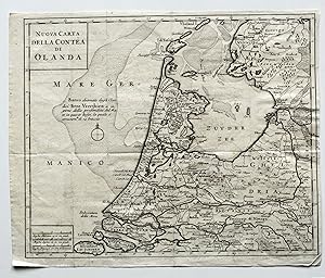
Nuova Carta Della Contea di Olanda.
Editť par o.J. um 1741, 1741
Vendeur : Versandantiquariat HŲsl, Neuried, Allemagne
…valuation du vendeur 5 sur 5 ťtoiles
Carte
EUR 30
Autre deviseEUR 9,50 expťdition depuis Allemagne vers Etats-UnisQuantitť disponible : 1 disponible(s)
Ajouter au panierEtat : Gut. Kupferstichkarte, mehrfach gefaltet, sauber geklebter EinriŖ am rechten Rand, ansonsten nur kleine Gebrauchsspuren, ordentlicher Zustand. Sprache / Language: it 1 Seiten. ca. 28,6 x 34,8 cm.
-
Brielle ingenomen, door de Watergeuzen, in 't jaar 1572.
Vendeur : Rob Kok Old Books & Prints, Loosdrecht, NH, Pays-Bas
…valuation du vendeur 5 sur 5 ťtoiles
EUR 15
Autre deviseEUR 26 expťdition depuis Pays-Bas vers Etats-UnisQuantitť disponible : 1 disponible(s)
Ajouter au panierZ.j.[=1752]. Kopergravure. 152 x 195 - Papier 210 x 240 mm. Uit: Wagenaar - Vaderlandsche Historie, Deel 6. [112208].
-
EUR 28,01
Autre deviseEUR 48,99 expťdition depuis Allemagne vers Etats-UnisQuantitť disponible : Plus de 20 disponibles
Ajouter au panierEtat : New.
-
EUR 38,60
Autre deviseEUR 48,99 expťdition depuis Allemagne vers Etats-UnisQuantitť disponible : Plus de 20 disponibles
Ajouter au panierEtat : New.
-
Catalogus van het vermaarde cabinet bestaande in eene groote verzameling van uitmuntende konstige 1732 [Full Leather Bound]
Vendeur : Gyan Books Pvt. Ltd., Delhi, Inde
…valuation du vendeur 5 sur 5 ťtoiles
EUR 51,02
Autre deviseGratuit expťdition depuis Inde vers Etats-UnisQuantitť disponible : Plus de 20 disponibles
Ajouter au panier -

"Nieuwe en beknopte hand-atlas" - Titel Titelblatt title page / carte map Karte
Editť par Amsterdam um 1760., 1760
Langue: nťerlandais
Vendeur : Antiquariat Steffen VŲlkel GmbH, Seubersdorf, Allemagne
Membre d'association : ILAB VDA
…valuation du vendeur 5 sur 5 ťtoiles
Carte
EUR 19,99
Autre deviseEUR 49 expťdition depuis Allemagne vers Etats-UnisQuantitť disponible : 1 disponible(s)
Ajouter au panierOriginal Kupferstich-Titel aus dem Atlas: "Nieuwe en beknopte hand-atlas : Bestaande in eene verzameling van eenige der algemeenste en nodigste landkaarten" aus dem 18. Jahrhundert. - Blattmasse: ca.26 x41 cm - gut erhalten. - Interesting book illustrating the English siege and attack on Quebec, which resulted in the city's capture and ultimately the end of the French and Indian War. Tirion closely copied the details from a similar plan by Thomas Jefferys. The naval and army positions are graphically depicted and keyed to a table at upper right. Wir kaufen und verkaufen alte BŁcher, Handschriften, Zeichnungen, Autographen, Grafiken und Fotografien. Wir sind stets am Ankauf von kompletten Bibliotheken, Sammlungen und Nachlšssen interessiert. Sprache: Niederlšndisch Gewicht in Gramm: 1550.
-
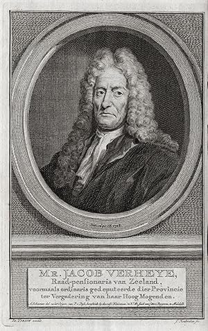
"Mr. Jacob Verheye" - Jacob Verheije (1640-1718) Zeeland Dutch Holland Verheye Portrait
Editť par 18. Jh.
Langue: nťerlandais
Vendeur : Antiquariat Steffen VŲlkel GmbH, Seubersdorf, Allemagne
Membre d'association : ILAB VDA
…valuation du vendeur 5 sur 5 ťtoiles
Art / Affiche / Gravure
EUR 19,99
Autre deviseEUR 49 expťdition depuis Allemagne vers Etats-UnisQuantitť disponible : 1 disponible(s)
Ajouter au panierOriginal Kupferstich-Portrait aus dem 18. Jh. -- Blattmasse: ca. 21 x 12,5 cm. Plattenmasse: ca. 18 x 11,5 cm. -- gut erhalten. || Original copper engraved portrait from the 18th century. -- in good condition. Wir kaufen und verkaufen alte BŁcher, Handschriften, Zeichnungen, Autographen, Grafiken und Fotografien. Wir sind stets am Ankauf von kompletten Bibliotheken, Sammlungen und Nachlšssen interessiert. Sprache: Niederlšndisch Gewicht in Gramm: 10.
-

"Mr. Anthony Vander Heim" - Anthonie van der Heim (1693-1746) Holland Dutch Den Haag Portrait
Editť par 18. Jh.
Langue: nťerlandais
Vendeur : Antiquariat Steffen VŲlkel GmbH, Seubersdorf, Allemagne
Membre d'association : ILAB VDA
…valuation du vendeur 5 sur 5 ťtoiles
Art / Affiche / Gravure
EUR 19,99
Autre deviseEUR 49 expťdition depuis Allemagne vers Etats-UnisQuantitť disponible : 1 disponible(s)
Ajouter au panierOriginal Kupferstich-Portrait aus dem 18. Jh. -- Blattmasse: ca. 18 x 11,5 cm. -- gut erhalten. || Original copper engraved portrait from the 18th century. -- in good condition. Wir kaufen und verkaufen alte BŁcher, Handschriften, Zeichnungen, Autographen, Grafiken und Fotografien. Wir sind stets am Ankauf von kompletten Bibliotheken, Sammlungen und Nachlšssen interessiert. Sprache: Niederlšndisch Gewicht in Gramm: 10.
-
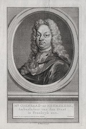
"Mr. Coenraad van Heemskerk" - Coenraad van Heemskerck (1646-1702) Dutch politician Den Haag Amsterdam Portrait
Editť par 18. Jh.
Langue: nťerlandais
Vendeur : Antiquariat Steffen VŲlkel GmbH, Seubersdorf, Allemagne
Membre d'association : ILAB VDA
…valuation du vendeur 5 sur 5 ťtoiles
Art / Affiche / Gravure
EUR 19,99
Autre deviseEUR 49 expťdition depuis Allemagne vers Etats-UnisQuantitť disponible : 1 disponible(s)
Ajouter au panierOriginal Kupferstich-Portrait aus dem 18. Jh. -- Blattmasse: ca. 18 x 11,5 cm. -- gut erhalten. || Original copper engraved portrait from the 18th century. -- in good condition. Wir kaufen und verkaufen alte BŁcher, Handschriften, Zeichnungen, Autographen, Grafiken und Fotografien. Wir sind stets am Ankauf von kompletten Bibliotheken, Sammlungen und Nachlšssen interessiert. Sprache: Niederlšndisch Gewicht in Gramm: 10.
-
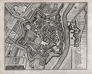
"Platte Grond der Stadt Tholen gemeten door D. W. C. Hattinga" - Tholen Noord-Brabant Nederland Niederlande Netherlands Holland
Editť par Amsterdam, 1753
Langue: franÁais
Vendeur : Antiquariat Steffen VŲlkel GmbH, Seubersdorf, Allemagne
Membre d'association : ILAB VDA
…valuation du vendeur 5 sur 5 ťtoiles
Carte
EUR 34,99
Autre deviseEUR 49 expťdition depuis Allemagne vers Etats-UnisQuantitť disponible : 1 disponible(s)
Ajouter au panierOriginal Kupferstich von 1753. -- Blatt-MaŖe: ca. 19 x 29 cm. -- gut erhalten. || Original copper engraving from 1753. -- in good condition. || Dies ist ein Original! - Kein Nachdruck! - Keine Kopie! -- This is an original! - No copy! - No reprint! Wir kaufen und verkaufen alte BŁcher, Handschriften, Zeichnungen, Autographen, Grafiken und Fotografien. Wir sind stets am Ankauf von kompletten Bibliotheken, Sammlungen und Nachlšssen interessiert. Sprache: FranzŲsisch Gewicht in Gramm: 10.
-
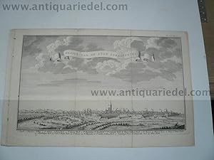
Gezigt van des Stad Straatsburg, anno 1780, Tition Isaak
Editť par Tirion Isaak, 1705-1765, 1765
Vendeur : Hammelburger Antiquariat, Hammelburg, Allemagne
…valuation du vendeur 5 sur 5 ťtoiles
EUR 80
Autre deviseEUR 30 expťdition depuis Allemagne vers Etats-UnisQuantitť disponible : 1 disponible(s)
Ajouter au panierHardcover. Etat : very good. Gezigt van des Stad Straatsburg, anno 1780, Tition Isaak, 16x27 cm.
-
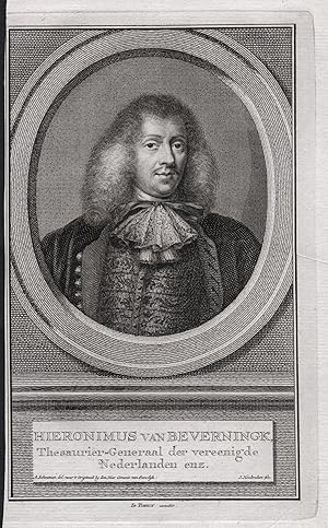
"Hieronimus van Beverningk" - Hieronymus van Beverninck (1614-1690) Dutch botanist Botaniker General Portrait
Editť par 18. Jh.
Langue: nťerlandais
Vendeur : Antiquariat Steffen VŲlkel GmbH, Seubersdorf, Allemagne
Membre d'association : ILAB VDA
…valuation du vendeur 5 sur 5 ťtoiles
Art / Affiche / Gravure
EUR 24,99
Autre deviseEUR 49 expťdition depuis Allemagne vers Etats-UnisQuantitť disponible : 1 disponible(s)
Ajouter au panierOriginal Kupferstich-Portrait aus dem 18. Jh. -- Blattmasse: ca. 21 x 12,5 cm. Plattenmasse: ca. 18 x 11,5 cm. -- links knapp beschnitten, sonst gut erhalten. || Original copper engraved portrait from the 18th century. -- closely trimmed on the left, otherwise in good condition. Wir kaufen und verkaufen alte BŁcher, Handschriften, Zeichnungen, Autographen, Grafiken und Fotografien. Wir sind stets am Ankauf von kompletten Bibliotheken, Sammlungen und Nachlšssen interessiert. Sprache: Niederlšndisch Gewicht in Gramm: 10.
-
Haarlem, anno 1750, Panorama, Tirion Isaac
Editť par Tirion Isaak, 1705-1765, 1765
Vendeur : Hammelburger Antiquariat, Hammelburg, Allemagne
…valuation du vendeur 5 sur 5 ťtoiles
EUR 99
Autre deviseEUR 30 expťdition depuis Allemagne vers Etats-UnisQuantitť disponible : 1 disponible(s)
Ajouter au panierHardcover. Etat : very good. Haarlem, anno 1750, Panorama, Tirion Isaac Haarlem, anno 1750, Panorama, Tirion Isaac, size of the leaf: 20x43 cm., little restoration on fold.
-

Antique Map-SLUYS-SLUIS-FORTIFICATION-ZEELAND-PLAN-NETHERLANDS-Tirion-c. 1750
Editť par c. 1750, 1750
Vendeur : Pictura Prints, Art & Books, Overasselt, Pays-Bas
Membre d'association : ILAB NVVA
…valuation du vendeur 4 sur 5 ťtoiles
EUR 55
Autre deviseEUR 20 expťdition depuis Pays-Bas vers Etats-UnisQuantitť disponible : 1 disponible(s)
Ajouter au panierIsaak Tirion (illustrateur). 'GROND-TEKENING VAN DE STAD SLUIS IN VLAANDEREN.'Original antique print showing a plan of the fortified city of Sluis in the province of Zeeland, The Netherlands. With compass rose, key and scale.Made by an anonymous engraver after Isaak Tirion.Medium: Engraving/etching on hand laid (verge) paper.Sheet size: 28.5 x 21 cm (11.22 x 8.27 inch). Image size: 24.3 x 17 cm. (9.57 x 6.69 inch).SLUYS-SLUIS-FORTIFICATION-ZEELAND-PLAN-NETHERLANDS | PCOA55-21BACKGROUND INFORMATIONPublished by Isaak Tirion, Amsterdam, c. 1750.Biography artist: Isaak Tirion (1705-1765) was a Dutch publisher and cartographer based in Amsterdam. He produced various atlases and topographical works, known for their high-quality engravings and geographical accuracy. His maps were often based on the work of leading French cartographer Guillaume de l'Isle. Condition: very good, given age. Original folds as issued. General age-related toning and/or occasional minor defects from handling. Please study scan carefully.
-
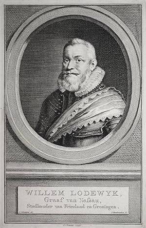
"Willem Lodewyk, Graf van Nassau." - Wilhelm Ludwig v. Nassau Dillenburg (1560-1620) Friesland Groningen Drenthe Portrait
Editť par 18. Jh.
Langue: allemand
Vendeur : Antiquariat Steffen VŲlkel GmbH, Seubersdorf, Allemagne
Membre d'association : ILAB VDA
…valuation du vendeur 5 sur 5 ťtoiles
Art / Affiche / Gravure
EUR 14,99
Autre deviseEUR 49 expťdition depuis Allemagne vers Etats-UnisQuantitť disponible : 1 disponible(s)
Ajouter au panierOriginal Kupferstich-Portrait aus dem 18. Jahrhundert. -- Blattmasse: ca. 18 x 11,5 cm. -- auf Tršgerkarton montiert. -- gut erhalten. || Original copper engraved portrait from the 18th century. -- mounted on cardboard. -- in good condition. Wir kaufen und verkaufen alte BŁcher, Handschriften, Zeichnungen, Autographen, Grafiken und Fotografien. Wir sind stets am Ankauf von kompletten Bibliotheken, Sammlungen und Nachlšssen interessiert. Sprache: Deutsch Gewicht in Gramm: 10.
-
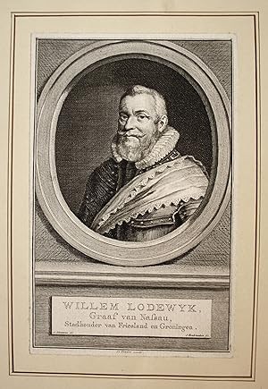
"Willem Lodewyk, Graf van Nassau." - Wilhelm Ludwig v. Nassau Dillenburg (1560-1620) Friesland Groningen Drenthe Portrait
Editť par 18. Jh.
Langue: allemand
Vendeur : Antiquariat Steffen VŲlkel GmbH, Seubersdorf, Allemagne
Membre d'association : ILAB VDA
…valuation du vendeur 5 sur 5 ťtoiles
Art / Affiche / Gravure
EUR 14,99
Autre deviseEUR 49 expťdition depuis Allemagne vers Etats-UnisQuantitť disponible : 1 disponible(s)
Ajouter au panierOriginal Kupferstich-Portrait aus dem 18. Jahrhundert. -- Blattmasse: ca. 18 x 11,5 cm. -- mit schmalen Rand, auf Tršgerkarton aufgezogen. -- gut erhalten. || Original copper engraved portrait from the 18th century. -- Fully mounted on cardboard. -- in good condition. Wir kaufen und verkaufen alte BŁcher, Handschriften, Zeichnungen, Autographen, Grafiken und Fotografien. Wir sind stets am Ankauf von kompletten Bibliotheken, Sammlungen und Nachlšssen interessiert. Sprache: Deutsch Gewicht in Gramm: 10.
-

Hedendaagsche historie, of tegenwoordige staat der Vereenigde Nederlanden
Editť par Amsterdam : Isaak Tirion, 1739
EUR 110
Autre deviseEUR 50 expťdition depuis Pays-Bas vers Etats-UnisQuantitť disponible : 1 disponible(s)
Ajouter au panierEtat : Good. 2nd Edition. Lederen band met goudopdruk op rug, (uitvouwbare z/w illustraties), (30),638,(42) pagina's, 8vo. Hedendaagsche Historie, of Tegenwoordige Staat van Alle Voilkeren; XIde deels, Eerste Stukje; vervattende eenen aanvang der Beschryving van den Tegenwoordigen Staat der Vereenigde Nederlanden.; Groot ex libris op binnenzijde kaft; daardoor verbruind op eerste bladzijden; restjes verwijderd zegeltje op rug.
-
Hedendaagsche Historie of Tegenwoordige staat van alle volkeren, XII-de deel: vervolgende de beschryving der vereenigde Nederlanden, te Amsterdam, by Isaak Tirion, boekverkooper op den Nieuwendyk by den Dam in Hugo Grotius, 1740, met privilegie van haar Ed. Groot Mog. de Heeren Staaten van Holland en Westvriesland.
Editť par Amsterdam, 1740
Vendeur : Antiquariaat Meuzelaar, Heusden, NB, Pays-Bas
…valuation du vendeur 5 sur 5 ťtoiles
EUR 325
Autre deviseEUR 24,30 expťdition depuis Pays-Bas vers Etats-UnisQuantitť disponible : 1 disponible(s)
Ajouter au panierContemporary Half Leather. It is part XII. This book is complete with 12 engraved plates: plans of 's-Hertogenbosch, Crevecoeur, Breda, Graave, Sluis in Vlaanderen; maps of de Meiery van 's Hertogenbosch, de Baronie van Breda, drie Landen van Overmaaze (Valkenburg, Daalhem, 's Hertogenrade); views of Bergen op Zoom, Sluis, 't Sas van Gend; engraving of Grafstede van Engelbert II. Place Printed: Amsterdam Frontispiece / Title Page / Half Title / 9 NNP / 608 Pages / 20 NNP / 8 Folding maps / 3 Folding Views / 1 Folding Plates (1-10) Spine cracked in the middle and on the sides. Height (cm): 20,8 Width (cm): 13,5 Thickness (cm): 4,7 Weight (kg): 0,784.
-
Het Verheerlykt Kleeschland of Kabinet van Kleefsche Oudheden en Gezigten van Steden Dorpen Sloten Adelyke Huizen Kerken Torens Poorten; en andere voornaame Stad-en Land-Gebouwen in Kleefschland. Behelzende Honderd Gezigten. Verheerlykt Nederland.
Editť par Amsterdam: P. Schouten, J. de Groot en Warnars. Leyden: S en J Luchtmans. Dordrecht: A en P Blusse. Harlinghen: Volkert van der Plaats. c. 1746. *, 1746
Vendeur : Travis & Emery Music Bookshop ABA, London, Royaume-Uni
Membre d'association : ABA ILAB
…valuation du vendeur 5 sur 5 ťtoiles
EUR 1†776,87
Autre deviseEUR 28,76 expťdition depuis Royaume-Uni vers Etats-UnisQuantitť disponible : 1 disponible(s)
Ajouter au panierSmall 4to. Engraved by Paul van Liemder, variously dated 1732-1746. 100 views numbered 1-100 in the list of views and printed on 48 plates. Some foxing. Contemporary full leather, tooled on front and back. Joints rubbed.
-
NIEUWE KAART VAN DE GROOTBRITTANNISCHE VOLKPLANTINGEN IN NOORD AMERICA.
Editť par Amsterdam, 1755
Vendeur : John K King Used & Rare Books, Detroit, MI, Etats-Unis
…valuation du vendeur 5 sur 5 ťtoiles
EUR 748,32
Autre deviseEUR 4,63 expťdition vers Etats-UnisQuantitť disponible : 1 disponible(s)
Ajouter au panierPaperback. Etat : Very Good. Partially colored, 14.5 x 17.5" plus margins, matted, minor stain at gutter else nice. Covers Atlantic Ocean to just north of Great Lakes, west to Miss. River and south touching northern Florida. In the Michigan/Great Lakes area, Lake Huron is on the upper northwest side of the future state, Lake Superior is to the north and Lake Michigan is pretty much where it should be. Shown in "Michigan" is Fort Pontchartrain near what is now Detroit up to St. Ignace and over to Ste. Marie from the Upper Peninsula. Can't tell that we're from Michigan can you?
-
Het Verheerlykt Kleeschland of Kabinet van Kleefsche Oudheden en Gezigten van Steden Dorpen Sloten Adelyke Huizen Kerken Torens Poorten; en andere voornaame Stad-en Land-Gebouwen
Editť par Isaak Tirion
Vendeur : R.E & G.B Way, NEWMARKET, SUFFO, Royaume-Uni
Membre d'association : PBFA
…valuation du vendeur 5 sur 5 ťtoiles
EUR 2†665,30
Autre deviseEUR 12,65 expťdition depuis Royaume-Uni vers Etats-UnisQuantitť disponible : 1 disponible(s)
Ajouter au panierHardcover. Etat : Good. 1745-1773, volumes 1-9 ( without the supplement), in 3 volumes, 757 views, Part 1 94 views, part 2 84 views, part 3 89 views, part 4 99 views, part 5 91 views, part 6 82 views, part7 96 views, part 8 58 views, part 9 64 views, small 4to, contemporary calf, spines worn, piece missing from the bottom of one spine, lacks labels, contents nice and clean,
-

Kaart van het Westelyk Gedeelte van Nieuw Mexico en van California.
Editť par Amsterdam: Isaak Tirion, 1765, 1765
Vendeur : Arader Galleries - AraderNYC, New York, NY, Etats-Unis
…valuation du vendeur 5 sur 5 ťtoiles
EUR 694,09
Autre deviseGratuit expťdition vers Etats-UnisQuantitť disponible : 1 disponible(s)
Ajouter au panierCopper-engraved map (13 3/4 x 14 1/2 in.; 35 x 36.8 cm, sight) of Baja California and Sonora, bounded on the north by the Colorado and Gila Rivers and approximately Mozatlan in the south; several folds as issued. Matted and enclosed in mylar. (6.5B.2C) A scarce and important eighteenth-century map detailing the Spanish-Mexican borderlands in the California region. It focuses on the Gulf of California, Baja California, parts of Southern California including Cape San Diego (site of the modern city) and present-day Arizona. The Peninsula and Sonora are dotted with towns, indigenous villages, Jesuit missions, Spanish garrisons, watering places ("plaats"), and some offshore detail, with mountain ranges rendered in profile. Cartographically this map falls between the seminal mapping of Father Kino at the end of the 17th century, which reattached insular California to the mainland, and the important discoveries of the Dominguez-Escalante expedition (1775). The various Jesuit settlements are identified with vignettes of churches, particularly on the Baja Peninsula and the Mexican mainland. Of note is the site identified by Father Kino as the Casa Grande on the Gila River. Although marked as a mission here, it is in fact a Native American Indian ruin of architectural enormity now protected by the National Park Service. Tirion was a Dutch publisher who is chiefly known for his maps and atlases. This map was included in his his 3-volume Hedendaagsche Historie, of Tegenwoordige Staat van Amerika (1766-1769)-a history of the Present States of America, with a substantial portion devoted to Spanish settlements in North and South America. REFERENCE: Cf. Sabin 31212.
-
Nieuwe en Beknopte Hand-Atlas bestaande in eene verzameling van eenige der algemeenste en nodigste Landkaarten.
Editť par Te Amsterdam: Isaak Tirion, [ca 1769]., 1769
Vendeur : Arader Galleries - AraderNYC, New York, NY, Etats-Unis
…valuation du vendeur 5 sur 5 ťtoiles
EUR 39†042,33
Autre deviseGratuit expťdition vers Etats-UnisQuantitť disponible : 1 disponible(s)
Ajouter au panierFolio (17 6/8 x 11 inches). Letterpress title-page, 2-page register. FINE engraved double-page double-hemisphere map of the world dated 1744, and 109 maps and city plans on 111 sheets, all mounted on guards and with FINE ORIGINAL HAND-COLOUR (map of Japan with light marginal thumbing, else EXCEPTIONALLY BRIGHT). Contemporary half-calf, speckled boards (worn at the extremities with minor loss). Provenance: Contemporary mss foliation to verso of maps; with modern bookplate Jan Paulus Schumacher on paste down. A fine example of Tirion's atlas, first published by Tirion before about 1740 with only 34 maps. More of a bookseller and publisher than a geographer or cartographer, from his house on the Kalverstraat in Amsterdam he, and after his death his wife, published a number of important books and maps including the "Nieuwe en beknopte Hand-Atlas" until the late 1770s when it was re-issued by associated booksellers, Schouten, de Groot, Warnars etc until the mid 1780s. Maps related to America include the world map, ".Westelykste Deel der Weereld. Naar Westindie", 1754, showing North and South America; ".Noor Pool, 1735; "America" showing North and South America; "Mexico en Nieuw Granada.", 1765; ".Nieuw Mexico en van California", 1765; "Panama", ". Grootbrittannische Volkplantingen in Noord America.", 1755, showing New England; "Peru, Chili, Paraguay. Brazil", 1765; "Aller-Heiligen Baay. Brazil", ".Cayenne"; ".Suriname en Berbice"; ".Guajana."; ".Westindische Eilanden", ".Martenique"; a magnificent plan of the city of New Orleans with insets of the Gulf of Mexico and the mouth of the Mississippi; "Kanada", 1769; "Quebek.", 1759. Those related to Australia include the world map and "Oostelykste Deel der Weereld. naar Oostindie", 1755 showing the northern and western coastlines attached to New Guinea. Koeman III, Tir 4; Phillips 4282. Catalogued by Kate Hunter.
-
[Nieuwe en beknopte Hand-Atlas.]
Editť par [ Amsterdam : ca 1769.], 1769
Vendeur : Arader Galleries - AraderNYC, New York, NY, Etats-Unis
…valuation du vendeur 5 sur 5 ťtoiles
EUR 32†535,27
Autre deviseGratuit expťdition vers Etats-UnisQuantitť disponible : 1 disponible(s)
Ajouter au panierFolio (16 4/8 x 11 1/8 inches). Manuscript index leaf. FINE Double-page engraved map "Wereld Kaart" (1744) and 96 maps and city plans in contemporary hand-colour and mounted on guards after de I'lsle, de la Caille, Cruquius, Bolstra, Hattinga and others, EXTRA-ILLUSTRATED with 10 engraved double-page maps of the Americas (one or two occasional marginal stains). Contemporary speckled calf, each panel with modern gilt border of single fillet and hounds tooth roll with Pease family crest at each inner corner (rebacked to style, corners renewed). Provenance: Contemporary manuscript "Register" of maps and numbering on verso of each map; 20th-century Pease family supra libros on binding. A fine and attractive composite atlas first published by Tirion before about 1740 with only 34 maps. More of a bookseller and publisher than a geographer or cartographer, from his house on the Kalverstraat in Amsterdam he, and after his death his wife, published a number of important books and maps including the "Nieuwe en beknopte Hand-Atlas" until the late 1770s when it was re-issued by associated booksellers, Schouten, de Groot, Warnars etc until the mid 1780s. The maps related to America include: "Nieuwe Kaart van het Westelykste Deel der Weereld" (1754); "Nieuwe Wereld Kaart waar in de Reizen van den H. Anson"; "Nieuwe Kaart van America"; "Nieuwe Kaart van de Grootbrittannische Volkplantingen in Noord America" (1755); "Algemeene Kaart van de westindische Eilanden"; "Guajana of de Wilden-Kust" ; "Kaart van de Landengte van Panama"; ".Nieuwe Mexico en van California" (1765); ".Kanada." (1769); " Mexico en Nieuwe Granada" (1765); "Quebek." (1759); "Aller-Heiligen Baay. Brazil "; "Missisippi." showing a detailed plan of New Orleans ; " Martinique " (loosely inserted). Koeman Tir 4, III, pp 129-132. Catalogued by Kate Hunter.

![Image du vendeur pour Catalogus van het vermaarde cabinet bestaande in eene groote verzameling van uitmuntende konstige 1732 [Full Leather Bound] mis en vente par Gyan Books Pvt. Ltd.](https://pictures.abebooks.com/inventory/md/md32085922215.jpg)
