
Montant total (1 article articles) :
Destination de la commande :

weiland carl ferdinand (26 résultats)
Commentaires
Passer aux résultats principaux de la recherche
Filtres de recherche
Type d'article
- Tous les types de produits
- Livres (15)
- Magazines & Périodiques (Aucun autre résultat ne correspond ŕ ces critčres)
- Bandes dessinées (Aucun autre résultat ne correspond ŕ ces critčres)
- Partitions de musique (Aucun autre résultat ne correspond ŕ ces critčres)
- Art, Affiches et Gravures (Aucun autre résultat ne correspond ŕ ces critčres)
- Photographies (Aucun autre résultat ne correspond ŕ ces critčres)
- Cartes (11)
- Manuscrits & Papiers anciens (Aucun autre résultat ne correspond ŕ ces critčres)
Etat En savoir plus
- Neuf (7)
- Comme neuf, Trčs bon ou Bon (Aucun autre résultat ne correspond ŕ ces critčres)
- Assez bon ou satisfaisant (4)
- Moyen ou mauvais (1)
- Conformément ŕ la description (14)
Particularités
- Ed. originale (2)
- Signé (Aucun autre résultat ne correspond ŕ ces critčres)
- Jaquette (Aucun autre résultat ne correspond ŕ ces critčres)
- Avec images (23)
- Sans impressions ŕ la demande (23)
Langue (3)
Livraison gratuite
Pays
Evaluation du vendeur
-

Bibel Atlas: Nach Den Neuesten Und Besten Hulfsmitteln (1832) (English and German Edition)
Vendeur : Best Price, Torrance, CA, Etats-Unis
Évaluation du vendeur 5 sur 5 étoiles

EUR 16,84
Autre deviseEUR 7,59 expédition vers Etats-UnisQuantité disponible : 2 disponible(s)
Ajouter au panierEtat : New. SUPER FAST SHIPPING.
-

Bibel Atlas: Nach Den Neuesten Und Besten Hulfsmitteln (1832) (German Edition)
Vendeur : Best Price, Torrance, CA, Etats-Unis
Évaluation du vendeur 5 sur 5 étoiles
EUR 16,84
Autre deviseEUR 7,59 expédition vers Etats-UnisQuantité disponible : 1 disponible(s)
Ajouter au panierEtat : New. SUPER FAST SHIPPING.
-

Bibel Atlas
Edité par Kessinger Publishing, LLC, 2010
ISBN 10 : 1160808902 ISBN 13 : 9781160808903
Langue: allemand
EUR 28,90
Autre deviseEUR 48,99 expédition depuis Allemagne vers Etats-UnisQuantité disponible : Plus de 20 disponibles
Ajouter au panierEtat : New. KlappentextrnrnThis scarce antiquarian book is a facsimile reprint of the original. Due to its age, it may contain imperfections such as marks, notations, marginalia and flawed pages. Because we believe this work is culturally important, we have.
-
[Collection d'uniformes de l'armée française et de ses alliés en 1812.] / Gravures de C. Weiland 1812 [Full Leather Bound]
Vendeur : Gyan Books Pvt. Ltd., Delhi, Inde
Évaluation du vendeur 5 sur 5 étoiles
EUR 50,98
Autre deviseGratuit expédition depuis Inde vers Etats-UnisQuantité disponible : Plus de 20 disponibles
Ajouter au panier -

Bibel-Atlas. (English and German Edition)
Vendeur : Majestic Books, Hounslow, Royaume-Uni
Évaluation du vendeur 5 sur 5 étoiles
EUR 27,15
Autre deviseEUR 7,49 expédition depuis Royaume-Uni vers Etats-UnisQuantité disponible : 4 disponible(s)
Ajouter au panierEtat : New. Print on Demand pp. 114.
-

Süd America entworfen und gezeichnet von C. F. Weiland.
Edité par Weimar, 1829
Vendeur : Bolivar Old Prints Anticuario, Barcelona, B, Espagne
Membre d'association : AILA ILAB
Évaluation du vendeur 4 sur 5 étoiles

Carte
EUR 120
Autre deviseEUR 25 expédition depuis Espagne vers Etats-UnisQuantité disponible : 1 disponible(s)
Ajouter au panierEtat : Bueno. Precioso mapa de Sudamérica coloreado por las líneas fronteriza de los diferentes países. El mapa se encuentra en alemán puesto que se publicó en Weimar en el ańo 1829 por Carl Ferdinand Weiland (1782-1847) quien fue un cartógrafo y geógrafo alemán que trabajó en la primera mitad del siglo XIX. Fue editor y grabador en la Weimar Geographisches Institut, donde produjo mapas detallados de Europa, América y otras regiones. Sus trabajos se caracterizaban por una alta precisión y claridad, contribuyendo a la cartografía alemana de la época. Publicó varios atlas, incluyendo el "Atlas von Amerika" (1823) y el "General-Atlas", utilizados tanto en educación como en la exploración geográfica. Como podemos observar por la fecha de publicación, el mapa muestra una situación muy importante para el continente pues la gran mayoría de territorios se han independizado recientemente. De hecho, incluso podemos ver la antigua república de la Gran Colombia compuesta por Ecuador, Colombia, Venezuela y Panamá. Además de este, también vemos las 3 guyanas (Aún bajo dominio europeo), Brasil, Perú, Bolívia (Con acceso al mar por el territorio de Atacama, a finales del s.XIX perderá ese territorio y entregará a Chile), Paraguay, Uruguay, Chile y las Provincias Unidas del Río de la Plata y Patagonia que más tarde formarán parte de la República Argentina. Entre las ciudades más importantes que podemos destacar encontramos Buenos Aires, Montevideo, Concepción, Santiago, Córdoba, La Paz, Lima, Guayaquil, Quito, Cartagena, Bogotá, Maracaibo y Caracas. Además, se muestra el relieve a partir de diferentes sombreados. Entre ellos encontramos la Cordillera de Los Andes, los sistemas montańosos del Amazonas? El título se encuentra abajo a la izquierda junto con la leyenda y escala. Estos elementos junto con el marco destacan un mapa muy elegante característico de los cartógrafos alemanes.Condición Muy buena, con una marca de plegado.Süd America entworfen und gezeichnet von C. F. Weiland.Palabras clave: "Sudamérica", "Colombia", "Brasil", "Perú", "Argentina". Alemán.
-

Weiland, C: Bibel Atlas
Edité par Kessinger Publishing, LLC, 2010
ISBN 10 : 1160808902 ISBN 13 : 9781160808903
Langue: allemand
Vendeur : AHA-BUCH GmbH, Einbeck, Allemagne
Évaluation du vendeur 5 sur 5 étoiles
EUR 35,42
Autre deviseEUR 61,51 expédition depuis Allemagne vers Etats-UnisQuantité disponible : 2 disponible(s)
Ajouter au panierTaschenbuch. Etat : Neu. Neuware - This scarce antiquarian book is a facsimile reprint of the original. Due to its age, it may contain imperfections such as marks, notations, marginalia and flawed pages. Because we believe this work is culturally important, we have made it available as part of our commitment for protecting, preserving, and promoting the world's literature in affordable, high quality, modern editions that are true to the original work.
-
Africa entworfen und gezeichnet von C. F. Weiland
Edité par Paris, 1836
Vendeur : Bolivar Old Prints Anticuario, Barcelona, B, Espagne
Membre d'association : AILA ILAB
Évaluation du vendeur 4 sur 5 étoiles
Carte
EUR 160
Autre deviseEUR 25 expédition depuis Espagne vers Etats-UnisQuantité disponible : 1 disponible(s)
Ajouter au panierNo Binding. Etat : Bueno. Uncommon map of Africa, published in Weimar (Germany) in 1836. At that time, the city was the center of the German cartography, thanks to the Geographischen Institutes (active 1804-1900). This map shows the African continent at the beginning of its modern colonization, with great details. Large format (51,5 x 59,5 cm, plus margen). Minors soling at the botton of the map, mainly outside the image, overall, in a good condition. Mapa poco común de África, publicado en Weimar (Alemania) en 1836. En ese momento, la ciudad era el centro de la cartografía alemana, gracias al Geographischen Institutes (activo de 1804 a 1900). Este mapa muestra el continente africano al comienzo de su colonización moderna, con gran detalle. Formato grande (51,5 x 59,5 cm, más margen). Pequeńas manchas en la parte inferior del mapa, principalmente fuera de la imagen, en general, en buen estado. Antique map of Africa. FRA. Muy buen estado.
-

Frankreich entworfen und gezeichnet von C. F. Weiland.
Edité par Weimar, Geographisches Institut, 1830
Vendeur : Buch- und Kunst-Antiquariat Flotow GmbH, Ottobrunn, Allemagne
Évaluation du vendeur 5 sur 5 étoiles
EUR 200
Autre deviseEUR 20 expédition depuis Allemagne vers Etats-UnisQuantité disponible : 1 disponible(s)
Ajouter au panierIn Orig.-Schuber, 58 x 52 cm. Zeigt Frankreich in den Grenzen von 1830, wobei Savoyen mit Nizza noch zum Königreich Sardinien gehört. Mit zwei Detail-Karten: Umgegend von Paris und Korsika. - In schöner sauberer Erhaltung Flächenkolorierte lithografische Karte, mehrfach gefaltet in 9 Segmenten auf Leinen aufgezogen.
-
Das Koenigreich Sachsen, entworfen und gezeichnet by Carl Ferdinand Weiland [Map of Saxony]
Edité par Published by Geograph. Instituts, 1840
Vendeur : Keoghs Books, Skipton, Royaume-Uni
Membre d'association : PBFA
Évaluation du vendeur 5 sur 5 étoiles
Carte Edition originale
EUR 237,42
Autre deviseEUR 32,27 expédition depuis Royaume-Uni vers Etats-UnisQuantité disponible : 1 disponible(s)
Ajouter au panierHardcover. Etat : Good. 1st Edition. Copper engraved map on wove paper, with outline colour. Two inset maps of Saschischen Schweiz and Dresden, including population table and distant scale. Map of Germany with highlight on Dresden. First Edition. Linen backing foxed with some light foxing to map, good condition. Card case worn at joints, small tears to fore edge, ink annotations, good condition , quarter cloth and marbled card case, linen backed map , 16.5 x 11.5 cm (folded), 48 x 66 cm (open) Hardback.
-

General Karte von der Schweiz. Nach den vorzüglichsten Hilfsmitteln bearbeitet und der neuesten Eintheilung begränzt
Edité par Weimar, Verlag des Geographischen Instituts, 1847,, 1847
Vendeur : Harteveld Rare Books Ltd., Marly, Suisse
Membre d'association : ILAB VEBUKU
Évaluation du vendeur 4 sur 5 étoiles
EUR 317,61
Autre deviseEUR 20 expédition depuis Suisse vers Etats-UnisQuantité disponible : 1 disponible(s)
Ajouter au panier44x63 cm, Stahlstichkarte. Kantonsgrenzen koloriert. Titelkartusche oben links, Maasstabe unten links. Beschreibungen oben und unten rechts, 1 Blatt auf Lwd aufgezogen. One of the earliest maps of the first Swiss train line, opened between Zürich and Baden in 1847. A beautiful example, printed on bluish paper, contemporary mounted on linen with a seller?s tag pasted verso, and accompanied by a marbled paper slipcase. A separately published pocket map of Switzerland, printed on light blue paper and mounted on linen was made in 1837 and corrected in 1847, when the first train line in Switzerland was built. It was connecting the Zürich with the town Baden. Please notify before visiting to see a book. Prices are excl. VAT/TVA (only Switzerland) & postage. Ursprungswerk: (Erste Eisenbahn-Linie Zürich-Baden): Die Schweiz oder Helvetische Eidgenossenschaft.
-
[Atlanten:] Bibel-Atlas, nach den neuesten und besten Hülfsmitteln gezeichnet von C. F. Weiland, und erläutert von C. Ackermann. Mit einer gestochenen Ansicht Jerusalems als Titelvignette und 11 (statt 12) grenzkolorierten Karten in Stahlstich.
Edité par Im Verlage des geographischen Instituts, Weimar, 1832
Langue: allemand
Vendeur : Antiquariat Rolf Bulang, Dautphetal, Allemagne
Membre d'association : ILAB VDA
Évaluation du vendeur 5 sur 5 étoiles
Edition originale
EUR 110
Autre deviseEUR 45 expédition depuis Allemagne vers Etats-UnisQuantité disponible : 1 disponible(s)
Ajouter au panierHardcover. Etat : Befriedigend. Erste Ausgabe. V, 75 S., 11 (von 12) Karten. Etwas späterer Halblederband. Angebunden sind das lithographierte Titelblatt (Eduard Schuler nach Overbeck) und 21 Stahlstiche aus der Carlsruher Bibel von 1836. "This atlas has to be regarded as one of the oldest and most detailed works of its kind in German-speaking Europe. 18 copies have been identified in libraries and private collections" (Espenhorst: Petermann's Planet, Vol. I, p. 165). Der Einband berieben und der Vorderschnitt mit größerem altem Tintenfleck, der bis in den Seitenrand des Textteils hineinläuft. Durchgängig stockfleckig, insgesamt handelt es sich jedoch um ein noch ordentliches Exemplar dieses frühen Versuchs, sich der biblischen Realien mittels Landkarten zu versichern.
-

Australien. Stahlstich-Karte von 1823 1:45000000.
Edité par Geographisches Institut, Weimar, 1823
Vendeur : Versandantiquariat Hösl, Neuried, Allemagne
Évaluation du vendeur 5 sur 5 étoiles
Carte
EUR 100
Autre deviseEUR 9,50 expédition depuis Allemagne vers Etats-UnisQuantité disponible : 1 disponible(s)
Ajouter au panierEtat : Ausreichend. Karte des südpazifischen Raumes mit Australien, Neuseeland, Philippinen, Malaysia und insbesondere der weitverzeigten Inselwelt. Die grenzkolorierte Karte mit der Jahreszahl 1823 stammt vermutlich aus dem 'Allgemeinen Hand-Atlas der ganzen Erde' von C.F. Weiland (* 1782; 18. Mai 1847 in Gera), deutscher Kartograph und württembergischer Hauptmann. Das Blatt ist stark stockfleckig/fleckig, verknittert, zweifach gefaltet. Kleiner Einriss am Falz unten. Rückseite mit neuerem aufgeklebtem Papierstück zur Fixierung von Einrissen. Alter handschriftl. Maßstab-Vermerk rechts unten. Sprache / Language: de 1 Seiten. ca. 30,4 x 40,4 cm.
-

Theil von Ostpreussen. - Partie de la Prusse Orientale. - Sect. 8. Kupferstich-Karte, zeigt links oben das Kurische Haff mit Labiau, Gilge, Memel-Delta, rechts oben Tilsit, in der rechten unteren Ecke Insterburg, sowie Tapiau.
Edité par Weimar, im Verlage des Geograph. Instituts (um 1815)., 1815
Vendeur : NORDDEUTSCHES ANTIQUARIAT, Rostock, Allemagne
Évaluation du vendeur 5 sur 5 étoiles
EUR 180
Autre deviseEUR 20 expédition depuis Allemagne vers Etats-UnisQuantité disponible : 1 disponible(s)
Ajouter au panierQuer-4° (33 x 42 cm). Blattgrösse 43,5 x 54 cm. Leicht gebräunt, Ränder teils ein wenig abgegriffen. Mit Mittelfalz. (Topographisch-militairische Charte von den Königreichen Preussen und Polen und dem Grossherzogthum Posen in 85 Sectionen. Section 8) Oblast Kaliningrad (Rußland), Polessk, Matrossowka, Sowetsk, Tschernjachowsk, Gwardeisk - Versandkosten innerhalb Deutschlands EUR 5,00 (versicherter Versand).
-
Vorder Indien.
Edité par Geograph. Insituts, Weimar., 1850
Vendeur : Studio Bibliografico Adige, Trento, TN, Italie
Évaluation du vendeur 5 sur 5 étoiles
EUR 165
Autre deviseEUR 39 expédition depuis Italie vers Etats-UnisQuantité disponible : 1 disponible(s)
Ajouter au panierPublication Reference: Espenhorst, J. Andree, Stieler, Meyer & Co., p. 26. Cf. Phillips, 6107. Cf. Espenhorst, J. Petermann's planet, v. 1, p. 134-135. Formato: 55x62 cm aperta (12 riquadri montati su tela), 14x19 cm chiusa, custodia coeva.
-

"Charte von dem Erzherzogthume Oesterreich ob- und unter der Ens nach den besten vorhandenen Materialien entworfen von C. F. Weiland".
Edité par Weimar, Verlag des Geograph. Instituts, 1825., 1825
Vendeur : Antiquariat MEINDL & SULZMANN OG, Wien - Vienna, Autriche
Évaluation du vendeur 5 sur 5 étoiles
EUR 180
Autre deviseEUR 35 expédition depuis Autriche vers Etats-UnisQuantité disponible : 1 disponible(s)
Ajouter au panierBlattgröße ca. 47 x 63 cm (bis an das Kartenbild beschnitten). Das Viertel ober dem Manhartsberg (Waldviertel), das Viertel unter dem Manhartesberg (Weinviertel), das Viertel unter dem Wienerwald (Industrieviertel) und das Viertel ober dem Wienerwald (Mostviertel) in gelbem Kolorit. Das Hausruckviertel, das Innviertel, das Mühlviertel, das Traunviertel und Salzburg in rotem Kolorit. Südöstlich auch das Burgenland mit dem Neusiedlersee.- Faltspuren geglättet. Das Kartenbild in sauberem Erhaltungszustand.
-

England entworfen und gezeichnet von C. F. Weiland. Weimar, im Verlage des Geograph. Instituts 1822.
Edité par Geographisches Institut, Weimar, 1822
Vendeur : Antiquariat Reinhold Berg eK Inh. R.Berg, Regensburg, Allemagne
Membre d'association : ILAB VDA
Évaluation du vendeur 5 sur 5 étoiles
Carte
EUR 220
Autre deviseEUR 24 expédition depuis Allemagne vers Etats-UnisQuantité disponible : 1 disponible(s)
Ajouter au panierOther. Copper engraving, hand colored in outline when published. An old map of England depicted by the German mapmaker Carl Ferdinand Weiland around 1822 sourounded by the Irish Sea, the English Channel and the North Sea. In the upper right corner the engraved title and explanations for the map on cities, towns, villages, castles, fortresses, lighthouses, streets and channels, further the kingdom of England and the duchy of Wales is marked in colors. 535 by 470mm (21 by 18˝ inches). 535 by 470mm (21 by 18˝ inches).
-

Das Königreich Daenemark nebst seinen Nebenlaendern in Europa entworfen von C. F. Weiland. Weimar, im Verlage des Geograph. Instituts. 1823
Edité par Geographisches Institut, Weimar, 1823
Vendeur : Antiquariat Reinhold Berg eK Inh. R.Berg, Regensburg, Allemagne
Membre d'association : ILAB VDA
Évaluation du vendeur 5 sur 5 étoiles
Carte
EUR 260
Autre deviseEUR 24 expédition depuis Allemagne vers Etats-UnisQuantité disponible : 1 disponible(s)
Ajouter au panierOther. Copper engraving, hand colored in outline when published. The fine engraved map shows the Kingdom of Denmark and the southern part of Sweden. The lower part of the map shows the northern part of Germany and Pomerania. An beautiful inset map of Iceland is in the upper right corner. The decorative cartouche is placed at the lower right side, with a mileage scale next to it. In the upper left corner is an inset map of the Faroe Islands. In exellent condition. 510 by 600mm (20 by 23˝ inches). 510 by 600mm (20 by 23˝ inches).
-

Scotland entworfen und gezeichnet von C. F. Weiland. Weimar, Im Verlage des Geograph: Instituts. 1821
Edité par Geographisches Institut, Weimar, 1821
Vendeur : Antiquariat Reinhold Berg eK Inh. R.Berg, Regensburg, Allemagne
Membre d'association : ILAB VDA
Évaluation du vendeur 5 sur 5 étoiles
Carte
EUR 280
Autre deviseEUR 24 expédition depuis Allemagne vers Etats-UnisQuantité disponible : 1 disponible(s)
Ajouter au panierOther. Copper engraving, hand colored in outline when published. A detailed and interesting map by the German mapmaker Carl Ferdinand Weiland depicting Scotland and the Shetland Island with an inset map. Engraved title and explanations for the map on cities, towns, villages, castles, fortresses, lighthouses, streets, channels, etc. In excellent condition. 530 by 460mm (20ľ by 18 inches). 530 by 460mm (20ľ by 18 inches).
-

Grosbritanien und Irland entworfen von C. F. Weiland. Weimar im Verlage des Geograph. Instituts 1822.
Edité par Geographisches Institut, Weimar, 1822
Vendeur : Antiquariat Reinhold Berg eK Inh. R.Berg, Regensburg, Allemagne
Membre d'association : ILAB VDA
Évaluation du vendeur 5 sur 5 étoiles
Carte
EUR 295
Autre deviseEUR 24 expédition depuis Allemagne vers Etats-UnisQuantité disponible : 1 disponible(s)
Ajouter au panierOther. Copper engraving, hand colored in outline when published. A detailed and interesting map by the German mapmaker Carl Ferdinand Weiland depicting the British Isles (England, Irland and Scotland), as well the Shetland Islands. Upper left side with the engraved title and explanations for the map on cities, towns, villages, castles, fortresses, lighthouses, streets, channels, etc. In the lower left corner a mileage scale for English, Irish and Scottish miles. 620 by 495mm (24˝ by 19˝ inches). 620 by 495mm (24˝ by 19˝ inches).
-
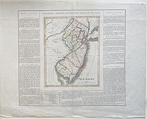
Geograpisch-statistische und historische Charte von Neu-Jersey
Edité par Geographischen Instituts, Weimar, 1825
Vendeur : Argosy Book Store, ABAA, ILAB, New York, NY, Etats-Unis
Membre d'association : ABAA ILAB
Évaluation du vendeur 5 sur 5 étoiles
EUR 348,39
Autre deviseEUR 5,07 expédition vers Etats-UnisQuantité disponible : 1 disponible(s)
Ajouter au panierunbound. J. Carez (illustrateur). Map. Engraving with original hand coloring. Image measures 11 3/4" x 9 1/4", sheet measures 19 1/4" x 24 1/2" Finely engraved double-page map of New Jersey. Shows counties, towns, waterways, topographical features, and roads. Includes historical and cultural information in German. This map appeared in the rare German edition of Carey and Lea's 1822 "A Complete Historical, Chronological, and Geographical American Atlas", published by the Weimar Geographischen Instituts. In very good condition. Minor wear to margin and centerfold, and two closed tears at upper margin, not affecting the image. Hard to find.
-

Schweden und Norwegen entworfen und gezeichnet von C. F. Weiland. Weimar, im Verlage des Geograph. Instituts 1824.
Edité par Geographisches Institut, Weimar, 1824
Vendeur : Antiquariat Reinhold Berg eK Inh. R.Berg, Regensburg, Allemagne
Membre d'association : ILAB VDA
Évaluation du vendeur 5 sur 5 étoiles
Carte
EUR 325
Autre deviseEUR 24 expédition depuis Allemagne vers Etats-UnisQuantité disponible : 1 disponible(s)
Ajouter au panierOther. Copper engraving, hand colored in outline when published. The fine engraved map of Scandinavia with Sweden, Norway and parts of Denmark, Finland and Estonia is surrounded with a decorative border. At the upper left corner we find the engraved title and in the lower right corner is a table with explanations of inhabitants, as well fortresses and villages. Above we find an overview and with a classification of cities and towns in Sweden and Norway to explain the deviations of the various cities names on this map. In excellent condition. 600 by 443mm (23˝ by 17˝ inches). 600 by 443mm (23˝ by 17˝ inches).
-
[Collection d'uniformes de l'armée française et de ses alliés en 1812.] / Gravures de C. Weiland 1812 [Leather Bound]
Date d'édition : 2022
Vendeur : Gyan Books Pvt. Ltd., Delhi, Inde
Évaluation du vendeur 5 sur 5 étoiles
EUR 29,21
Autre deviseGratuit expédition depuis Inde vers Etats-UnisQuantité disponible : Plus de 20 disponibles
Ajouter au panierLeather Bound. Etat : New. Language: french. Presenting an Exquisite Leather-Bound Edition, expertly crafted with Original Natural Leather that gracefully adorns the spine and corners. The allure continues with Golden Leaf Printing that adds a touch of elegance, while Hand Embossing on the rounded spine lends an artistic flair. This masterpiece has been meticulously reprinted in 2022, utilizing the invaluable guidance of the original edition published many years ago in 1812. The contents of this book are presented in classic black and white. Its durability is ensured through a meticulous sewing binding technique, enhancing its longevity. Imprinted on top-tier quality paper. A team of professionals has expertly processed each page, delicately preserving its content without alteration. Due to the vintage nature of these books, every page has been manually restored for legibility. However, in certain instances, occasional blurriness, missing segments, or faint black spots might persist. We sincerely hope for your understanding of the challenges we faced with these books. Recognizing their significance for readers seeking insight into our historical treasure, we've diligently restored and reissued them. Our intention is to offer this valuable resource once again. We eagerly await your feedback, hoping that you'll find it appealing and will generously share your thoughts and recommendations. Lang: - french, Pages:- 106, Print on Demand. If it is a multi-volume set, then it is only a single volume. We are specialised in Customisation of books, if you wish to opt different color leather binding, you may contact us. This service is chargeable. Product Disclaimer: Kindly be informed that, owing to the inherent nature of leather as a natural material, minor discolorations or textural variations may be perceptible. Explore the FOLIO EDITION (12x19 Inches): Available Upon Request. 106.
-
Bibel-Atlas / nach den neuesten und besten Hu?lfsmitteln gezeichnet von C. F. Weiland und erla?utert von C. Ackermann. 1832 [Leather Bound]
Date d'édition : 2024
Vendeur : Gyan Books Pvt. Ltd., Delhi, Inde
Évaluation du vendeur 5 sur 5 étoiles
EUR 29,27
Autre deviseGratuit expédition depuis Inde vers Etats-UnisQuantité disponible : Plus de 20 disponibles
Ajouter au panierLeather Bound. Etat : New. Language: German. Presenting an Exquisite Leather-Bound Edition, expertly crafted with Original Natural Leather that gracefully adorns the spine and corners. The allure continues with Golden Leaf Printing that adds a touch of elegance, while Hand Embossing on the rounded spine lends an artistic flair. This masterpiece has been meticulously reprinted in 2024, utilizing the invaluable guidance of the original edition published many years ago in 1832. The contents of this book are presented in classic black and white. Its durability is ensured through a meticulous sewing binding technique, enhancing its longevity. Imprinted on top-tier quality paper. A team of professionals has expertly processed each page, delicately preserving its content without alteration. Due to the vintage nature of these books, every page has been manually restored for legibility. However, in certain instances, occasional blurriness, missing segments, or faint black spots might persist. We sincerely hope for your understanding of the challenges we faced with these books. Recognizing their significance for readers seeking insight into our historical treasure, we've diligently restored and reissued them. Our intention is to offer this valuable resource once again. We eagerly await your feedback, hoping that you'll find it appealing and will generously share your thoughts and recommendations. Lang: - German, Pages: - 118, Print on Demand. If it is a multi-volume set, then it is only a single volume. We are specialised in Customisation of books, if you wish to opt different color leather binding, you may contact us. This service is chargeable. Product Disclaimer: Kindly be informed that, owing to the inherent nature of leather as a natural material, minor discolorations or textural variations may be perceptible. Explore the FOLIO EDITION (12x19 Inches): Available Upon Request. 118.
-

Hinter Indien nebst den Hinterindischen Inseln.
Date d'édition : 1847
Vendeur : Altea Antique Maps, London, Royaume-Uni
Membre d'association : ABA ILAB PBFA
Évaluation du vendeur 5 sur 5 étoiles
Carte
EUR 284,90
Autre deviseEUR 40,34 expédition depuis Royaume-Uni vers Etats-UnisQuantité disponible : 1 disponible(s)
Ajouter au panierWeimar Geographish Instituts, 1847. Original colour. 520 x 580mm. A detailed map of the East Indies from Burma east to the Philippines, with Indochina and Indonesia, coloured to show the possessions of the English, Dutch, Spanish, Danish and Portuguese.
-

Das Austral-Continent oder Neu Holland nach Kreusenstern King, Flinders, Freycinet, Oxley, Sturt, Mitchell in Mercators Projection.
Date d'édition : 1850
Vendeur : Altea Antique Maps, London, Royaume-Uni
Membre d'association : ABA ILAB PBFA
Évaluation du vendeur 5 sur 5 étoiles
Carte
EUR 356,13
Autre deviseEUR 40,34 expédition depuis Royaume-Uni vers Etats-UnisQuantité disponible : 1 disponible(s)
Ajouter au panierWeimar: Verlag des Geographischen Instituts, 1850. Coloured. 490 x 580mm. A good example. Australia, with insets of New South Wales, Sydney, Melville Island South Australia.
![Image du vendeur pour [Collection d'uniformes de l'armée française et de ses alliés en 1812.] / Gravures de C. Weiland 1812 [Full Leather Bound] mis en vente par Gyan Books Pvt. Ltd.](https://pictures.abebooks.com/inventory/md/md32085999654.jpg)

![Image du vendeur pour Das Koenigreich Sachsen, entworfen und gezeichnet by Carl Ferdinand Weiland [Map of Saxony] mis en vente par Keoghs Books](https://pictures.abebooks.com/inventory/md/md22845782074.jpg)
![Image du vendeur pour [Atlanten:] Bibel-Atlas, nach den neuesten und besten Hülfsmitteln gezeichnet von C. F. Weiland, und erläutert von C. Ackermann. Mit einer gestochenen Ansicht Jerusalems als Titelvignette und 11 (statt 12) grenzkolorierten Karten in Stahlstich. mis en vente par Antiquariat Rolf Bulang](https://pictures.abebooks.com/inventory/md/md30025088598.jpg)

![Image du vendeur pour [Collection d'uniformes de l'armée française et de ses alliés en 1812.] / Gravures de C. Weiland 1812 [Leather Bound] mis en vente par Gyan Books Pvt. Ltd.](https://pictures.abebooks.com/inventory/md/md30647449014.jpg)
![Image du vendeur pour Bibel-Atlas / nach den neuesten und besten Hu?lfsmitteln gezeichnet von C. F. Weiland und erla?utert von C. Ackermann. 1832 [Leather Bound] mis en vente par Gyan Books Pvt. Ltd.](https://pictures.abebooks.com/inventory/md/md30267275228.jpg)