Worldview (21 résultats)

Vendeur : PBShop.store UK, Fairford, GLOS, Royaume-UniPBShop.store UK
Contacter le vendeurVendeur avec une évaluation de 5 étoilesEtat: Neuf
EUR 11,18
EUR 3,81 expéditionExpédition depuis Royaume-Uni vers Etats-UnisQuantité disponible : 15 disponible(s)
UNK. Etat : New. New Book. Shipped from UK. Established seller since 2000.

Vendeur : GoPeachy, JACKSONVILLE, FL, Etats-UnisGoPeachy
Contacter le vendeurVendeur avec une évaluation de 1 étoilesEtat: Occasion - Assez bon
EUR 12,04
EUR 3,44 expéditionExpédition nationale : Etats-UnisQuantité disponible : 1 disponible(s)
Audio CD. Etat : Very Good. Ships from FL, USA with Tracking. Inspected, Complete and Guaranteed. Light wear to cover; No missing or torn pages; Binding solid. 30-Day Satisfaction Guarantee.
Vendeur : Majestic Books, Hounslow, , Royaume-UniMajestic Books
Contacter le vendeurVendeur avec une évaluation de 4 étoilesEtat: Neuf
EUR 9,70
EUR 7,52 expéditionExpédition depuis Royaume-Uni vers Etats-UnisQuantité disponible : 3 disponible(s)
Etat : New. pp. 8.
- Carte
Vendeur : Revaluation Books, Exeter, , Royaume-UniRevaluation Books
Contacter le vendeurVendeur avec une évaluation de 5 étoilesEtat: Neuf
EUR 6,00
EUR 11,57 expéditionExpédition depuis Royaume-Uni vers Etats-UnisQuantité disponible : 2 disponible(s)
Map. Etat : Brand New. 8 pages. 11.69x8.27x0.35 inches. In Stock.
Vendeur : PAPER CAVALIER UK, London, , Royaume-UniPAPER CAVALIER UK
Contacter le vendeurVendeur avec une évaluation de 5 étoilesEtat: Neuf
EUR 12,40
EUR 6,94 expéditionExpédition depuis Royaume-Uni vers Etats-UnisQuantité disponible : 1 disponible(s)
Etat : new. New.
Vendeur : Books Puddle, New York, NY, Etats-UnisBooks Puddle
Contacter le vendeurVendeur avec une évaluation de 4 étoilesEtat: Neuf
EUR 16,68
EUR 3,44 expéditionExpédition nationale : Etats-UnisQuantité disponible : 3 disponible(s)
Etat : New. pp. 8.
Vendeur : Grand Eagle Retail, Bensenville, IL, Etats-UnisGrand Eagle Retail
Contacter le vendeurVendeur avec une évaluation de 5 étoilesEtat: Neuf
EUR 20,49
Frais de port gratuitsExpédition nationale : Etats-UnisQuantité disponible : 1 disponible(s)
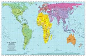
Folded. Etat : new. Folded. The Peters World Map shows countries in proportion to their relative sizes. It is based upon the German historian Arno Peters' decimal grid which divides the surface of the earth into 100 longitudinal fields of equal width and 100 latitudinal fields of equal height, a helpful corrective to the distort…ions of traditional maps. While the Peters' World Map is superior in its portrayal of proportions and sizes, its importance goes far beyond questions of cartographic accuracy. no less than our world view is at stake. This map helps us all to look at the world in a different way, showing the countries of the world in their real, relative sizes and has been updated to take account of upheavals in Europe and Asia following the end of the Cold War, the falling of the U.S.S.R and the break-up of Yugoslavia. The Peters World Map helps us all to look at the world in a different way, showing the countries of the world in their real, relative sizes and has been updated to take account of upheavals in Europe and Asia following the end of the Cold War, the falling of the U.S.S.R and the break-up of Yugoslavia. Shipping may be from multiple locations in the US or from the UK, depending on stock availability.
Vendeur : Kennys Bookshop and Art Galleries Ltd., Galway, GY, IrlandeKennys Bookshop and Art Galleries Ltd.
Contacter le vendeurVendeur avec une évaluation de 5 étoilesEtat: Neuf
EUR 12,75
EUR 10,50 expéditionExpédition depuis Irlande vers Etats-UnisQuantité disponible : Plus de 20 disponibles
Etat : New. 1996. map. . . . . .
Vendeur : Kennys Bookstore, Olney, MD, Etats-UnisKennys Bookstore
Contacter le vendeurVendeur avec une évaluation de 5 étoilesEtat: Neuf
EUR 15,09
EUR 9,06 expéditionExpédition nationale : Etats-UnisQuantité disponible : Plus de 20 disponibles
Etat : New. 1996. map. . . . . . Books ship from the US and Ireland.
Vendeur : Ria Christie Collections, Uxbridge, Royaume-UniRia Christie Collections
Contacter le vendeurVendeur avec une évaluation de 5 étoilesEtat: Neuf
EUR 10,83
EUR 13,86 expéditionExpédition depuis Royaume-Uni vers Etats-UnisQuantité disponible : Plus de 20 disponibles
Etat : New. In.
Vendeur : THE SAINT BOOKSTORE, Southport, , Royaume-UniTHE SAINT BOOKSTORE
Contacter le vendeurVendeur avec une évaluation de 5 étoilesEtat: Neuf
EUR 11,23
EUR 14,41 expéditionExpédition depuis Royaume-Uni vers Etats-UnisQuantité disponible : 2 disponible(s)
Sheet map, folded. Etat : New. New copy - Usually dispatched within 2 working days.

- Couverture souple
Vendeur : KALAMO BOOKS, Burriana, CS, EspagneKALAMO BOOKS
Contacter le vendeurVendeur avec une évaluation de 5 étoilesEtat: Neuf
EUR 13,35
EUR 17,86 expéditionExpédition depuis Espagne vers Etats-UnisQuantité disponible : 1 disponible(s)
Tapa blanda. Etat : Nuevo.

- Couverture souple
Vendeur : moluna, Greven, , Allemagnemoluna
Contacter le vendeurVendeur avec une évaluation de 5 étoilesEtat: Neuf
EUR 13,82
EUR 48,99 expéditionExpédition depuis Allemagne vers Etats-UnisQuantité disponible : Plus de 20 disponibles
Karte/Landkarte. Etat : New.

- Couverture souple
Vendeur : Aragon Books Canada, OTTAWA, ON, CanadaAragon Books Canada
Contacter le vendeurVendeur avec une évaluation de 3 étoilesEtat: Neuf
EUR 48,87
EUR 19,84 expéditionExpédition depuis Canada vers Etats-UnisQuantité disponible : 1 disponible(s)
Etat : New.

Vendeur : CitiRetail, Stevenage, Royaume-UniCitiRetail
Contacter le vendeurVendeur avec une évaluation de 5 étoilesEtat: Neuf
EUR 10,82
EUR 42,82 expéditionExpédition depuis Royaume-Uni vers Etats-UnisQuantité disponible : 1 disponible(s)
Folded. Etat : new. Folded. The Peters World Map shows countries in proportion to their relative sizes. It is based upon the German historian Arno Peters' decimal grid which divides the surface of the earth into 100 longitudinal fields of equal width and 100 latitudinal fields of equal height, a helpful corrective to the distort…ions of traditional maps. While the Peters' World Map is superior in its portrayal of proportions and sizes, its importance goes far beyond questions of cartographic accuracy. no less than our world view is at stake. This map helps us all to look at the world in a different way, showing the countries of the world in their real, relative sizes and has been updated to take account of upheavals in Europe and Asia following the end of the Cold War, the falling of the U.S.S.R and the break-up of Yugoslavia. The Peters World Map helps us all to look at the world in a different way, showing the countries of the world in their real, relative sizes and has been updated to take account of upheavals in Europe and Asia following the end of the Cold War, the falling of the U.S.S.R and the break-up of Yugoslavia. Shipping may be from our UK warehouse or from our Australian or US warehouses, depending on stock availability.
- Couverture souple
Vendeur : Aragon Books Canada, OTTAWA, ON, CanadaAragon Books Canada
Contacter le vendeurVendeur avec une évaluation de 3 étoilesEtat: Neuf
EUR 85,30
EUR 19,84 expéditionExpédition depuis Canada vers Etats-UnisQuantité disponible : 1 disponible(s)
Etat : New.

Vendeur : AussieBookSeller, Truganina, VIC, AustralieAussieBookSeller
Contacter le vendeurVendeur avec une évaluation de 5 étoilesEtat: Neuf
EUR 37,73
EUR 31,92 expéditionExpédition depuis Australie vers Etats-UnisQuantité disponible : 1 disponible(s)
Folded. Etat : new. Folded. The Peters World Map shows countries in proportion to their relative sizes. It is based upon the German historian Arno Peters' decimal grid which divides the surface of the earth into 100 longitudinal fields of equal width and 100 latitudinal fields of equal height, a helpful corrective to the distort…ions of traditional maps. While the Peters' World Map is superior in its portrayal of proportions and sizes, its importance goes far beyond questions of cartographic accuracy. no less than our world view is at stake. This map helps us all to look at the world in a different way, showing the countries of the world in their real, relative sizes and has been updated to take account of upheavals in Europe and Asia following the end of the Cold War, the falling of the U.S.S.R and the break-up of Yugoslavia. The Peters World Map helps us all to look at the world in a different way, showing the countries of the world in their real, relative sizes and has been updated to take account of upheavals in Europe and Asia following the end of the Cold War, the falling of the U.S.S.R and the break-up of Yugoslavia. Shipping may be from our Sydney, NSW warehouse or from our UK or US warehouse, depending on stock availability.

Vendeur : AHA-BUCH GmbH, Einbeck, AllemagneAHA-BUCH GmbH
Contacter le vendeurVendeur avec une évaluation de 5 étoilesEtat: Neuf
EUR 11,26
EUR 60,40 expéditionExpédition depuis Allemagne vers Etats-UnisQuantité disponible : 2 disponible(s)
Karte. Etat : Neu. Neuware.

Edité par Not Available, china 1979
- Couverture souple
Vendeur : Sunny Day Bookstore, SINGAPORE, , SingapourSunny Day Bookstore
Contacter le vendeurVendeur avec une évaluation de 4 étoilesEtat: Occasion - Très bon
EUR 53,31
EUR 12,94 expéditionExpédition depuis Singapour vers Etats-UnisQuantité disponible : 1 disponible(s)
Etat : Fine. The book is in fine condition.

- Carte
Vendeur : preigu, Osnabrück, Allemagnepreigu
Contacter le vendeurVendeur avec une évaluation de 5 étoilesEtat: Neuf
EUR 16,65
EUR 70,00 expéditionExpédition depuis Allemagne vers Etats-UnisQuantité disponible : 5 disponible(s)
(Land-)Karte. Etat : Neu. Peters World Map | Folded | Worldview | (Land-)Karte | Karte/Landkarte | Englisch | 1996 | WorldView Publications | EAN 9781872142029 | Verantwortliche Person für die EU: Libri GmbH, Europaallee 1, 36244 Bad Hersfeld, gpsr[at]libri[dot]de | Anbieter: preigu.
Edité par Kei shodo 1932
- Couverture souple
Vendeur : Sunny Day Bookstore, SINGAPORE, , SingapourSunny Day Bookstore
Contacter le vendeurVendeur avec une évaluation de 4 étoilesEtat: Occasion - Très bon
EUR 84,41
EUR 12,94 expéditionExpédition depuis Singapour vers Etats-UnisQuantité disponible : 1 disponible(s)
Etat : Fine. Number of books: 1 book.


