
Montant total (1 article articles) :
Destination de la commande :

1883 large map wales set (1 rÈsultats)
Commentaires
Passer aux rÈsultats principaux de la recherche
Filtres de recherche
Type d'article
- Tous les types de produits
- Livres (1)
- Magazines & PÈriodiques (Aucun autre rÈsultat ne correspond ‡ ces critËres)
- Bandes dessinÈes (Aucun autre rÈsultat ne correspond ‡ ces critËres)
- Partitions de musique (Aucun autre rÈsultat ne correspond ‡ ces critËres)
- Art, Affiches et Gravures (Aucun autre rÈsultat ne correspond ‡ ces critËres)
- Photographies (Aucun autre rÈsultat ne correspond ‡ ces critËres)
- Cartes (Aucun autre rÈsultat ne correspond ‡ ces critËres)
- Manuscrits & Papiers anciens (Aucun autre rÈsultat ne correspond ‡ ces critËres)
Etat En savoir plus
- Neuf (Aucun autre rÈsultat ne correspond ‡ ces critËres)
- Comme neuf, TrËs bon ou Bon (Aucun autre rÈsultat ne correspond ‡ ces critËres)
- Assez bon ou satisfaisant (Aucun autre rÈsultat ne correspond ‡ ces critËres)
- Moyen ou mauvais (Aucun autre rÈsultat ne correspond ‡ ces critËres)
- ConformÈment ‡ la description (1)
Reliure
- Toutes
- Couverture rigide (Aucun autre rÈsultat ne correspond ‡ ces critËres)
- Couverture souple (Aucun autre rÈsultat ne correspond ‡ ces critËres)
ParticularitÈs
- Ed. originale (Aucun autre rÈsultat ne correspond ‡ ces critËres)
- SignÈ (Aucun autre rÈsultat ne correspond ‡ ces critËres)
- Jaquette (Aucun autre rÈsultat ne correspond ‡ ces critËres)
- Avec images (1)
- Sans impressions ‡ la demande (1)
Langue (1)
Prix
- Tous les prix
- Moins de EUR 20 (Aucun autre rÈsultat ne correspond ‡ ces critËres)
- EUR 20 ‡ EUR 45 (Aucun autre rÈsultat ne correspond ‡ ces critËres)
- Plus de EUR 45
Livraison gratuite
- Livraison gratuite ‡ destination de France (Aucun autre rÈsultat ne correspond ‡ ces critËres)
Pays
Evaluation du vendeur
-
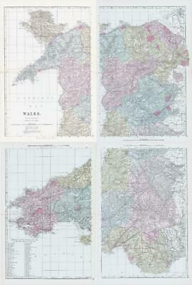
1883 Large Map WALES Set of 4 Maps Ordnance Survey by Bacon (BO48/49/50/51)
Vendeur : Antique Paper Company, ASHFORD, KENT, Royaume-Uni
…valuation du vendeur 2 sur 5 Ètoiles

EUR 100,42
Autre deviseEUR 6,88 expÈdition depuis Royaume-Uni vers FranceQuantitÈ disponible : 1 disponible(s)
Ajouter au panierListing Template 2018 Home About Us View Feedback Contact Us 1883 Large Map WALES Set of 4 Maps Ordnance Survey by Bacon (BO48/49/50/51)Description1883Large original colourAntique Map titled:WORCESTERSHIRE AND GLOUCESTERSHIREProvenanceTaken from 'New Large Scale Ordnance Map of the British Isles with plans of Towns, Copious letterpress descriptions, Alphabetical Indexes and census tables' published edited by George W Bacon, Agent by Appointment for the Ordnance Maps, 127 StrandGood condition overall with central fold as issued. Some light agetoning in the margins.Size of each mapapprox 35cm x 51cm (13.7in x 20in) including margins. View Our Categories Decorative Prints World Wide Maps Scotland Maps Architecture Design England Maps Royalty About UsWe specialise in selling all items that can be considered to be Antique Paper. * PRINTS * MAPS * HISTORICAL DOCUMENTS * POSTAL HISTORY * BOOKS * POSTERS * STAMPS * POSTCARDS * EPHEMERA And anything else that is considered Antique and made of Paper. ALL OF OUR ITEMS ARE ORIGINAL ANTIQUES - NOT MODERN COPIES. We are also very keen buyers of anything similar and especially after better collections, original archives, whole libraries and better single items and have and#163;250,000 in cash funds at anyone time to buy the right items. Contact UsIf you have any questions then please do not hesitate to contact us through the eBay messaging system. Feedback We will always help you to have a 100% positive happy buying experience. Contact us if you are unhappy about any aspect of your purchase from us. We only want five star feedback from you so buy with confidence.