Montant total (1 article articles) :
Destination de la commande :

antique map ancient greece sage (1 résultats)
Commentaires
Passer aux résultats principaux de la recherche
Filtres de recherche
Type d'article
- Tous les types de produits
- Livres (Aucun autre résultat ne correspond ŕ ces critčres)
- Magazines & Périodiques (Aucun autre résultat ne correspond ŕ ces critčres)
- Bandes dessinées (Aucun autre résultat ne correspond ŕ ces critčres)
- Partitions de musique (Aucun autre résultat ne correspond ŕ ces critčres)
- Art, Affiches et Gravures (Aucun autre résultat ne correspond ŕ ces critčres)
- Photographies (Aucun autre résultat ne correspond ŕ ces critčres)
- Cartes (1)
- Manuscrits & Papiers anciens (Aucun autre résultat ne correspond ŕ ces critčres)
Etat En savoir plus
- Neuf (Aucun autre résultat ne correspond ŕ ces critčres)
- Comme neuf, Trčs bon ou Bon (Aucun autre résultat ne correspond ŕ ces critčres)
- Assez bon ou satisfaisant (Aucun autre résultat ne correspond ŕ ces critčres)
- Moyen ou mauvais (Aucun autre résultat ne correspond ŕ ces critčres)
- Conformément ŕ la description (1)
Reliure
- Toutes
- Couverture rigide (Aucun autre résultat ne correspond ŕ ces critčres)
- Couverture souple (Aucun autre résultat ne correspond ŕ ces critčres)
Particularités
- Ed. originale (Aucun autre résultat ne correspond ŕ ces critčres)
- Signé (Aucun autre résultat ne correspond ŕ ces critčres)
- Jaquette (Aucun autre résultat ne correspond ŕ ces critčres)
- Avec images (1)
- Sans impressions ŕ la demande (1)
Langue (1)
Prix
- Tous les prix
- Moins de EUR 20 (Aucun autre résultat ne correspond ŕ ces critčres)
- EUR 20 ŕ EUR 45
- Plus de EUR 45 (Aucun autre résultat ne correspond ŕ ces critčres)
Livraison gratuite
- Livraison gratuite ŕ destination de Etats-Unis (Aucun autre résultat ne correspond ŕ ces critčres)
Pays
Evaluation du vendeur
-
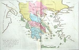
Antique Map ANCIENT GREECE LE SAGE HISTORICAL ATLAS, Hand Coloured 1818
Vendeur : Lindisfarne Prints, Shrewsbury, SHROP, Royaume-Uni
Évaluation du vendeur 5 sur 5 étoiles

Carte
EUR 29,49
Autre deviseEUR 10,88 expédition depuis Royaume-Uni vers Etats-UnisQuantité disponible : 1 disponible(s)
Ajouter au panierAntique Map ANCIENT GREECE WITH ITS DIVISIONS Engraved by Davies forLe Sage'sHistorical, Genealogical, Chronological & Geographical AtlasSecond Edition published London 1818A most attractive & informative map of Ancient Greece from the English edition of Le Sage's impressive French folio atlas. This is the second English edition and is updated until 1818. The map is surrounded on three sides ( please see the last image) by a wealth of historical information including data relating to the republics of Greece, geographical descriptions, philosophers, wars , heroes and much more.The map is finely engraved and clearly printed, while attractive hand colour accentuates detail. Centrefold as issued and in fine condition save for a light stain with tiny tear to the lower margin as evident from the image and some browning and chipping to the extreme edges. Blank verso Please go to close ups to view further images.Approx. 28" x 19.5" (710 mm x 490mm) overall , 16" x 10.5" ( 400mm x 270mm) map area only. A GENUINE ANTIQUE MAP GUARANTEED OVER 195 YEARS OLD FROM LINDISFARNE PRINTS 2 ITEMS COMBINED WITH A STANDARD SINGLE SHIPPING CHARGE. FREE STANDARD SHIPPING WORLDWIDE ON 3 ITEMS OR MORE! D1113 .