Montant total (1 article articles) :
Destination de la commande :

antique map birmingham england street (1 résultats)
Commentaires
Passer aux résultats principaux de la recherche
Filtres de recherche
Type d'article
- Tous les types de produits
- Livres (Aucun autre résultat ne correspond ŕ ces critčres)
- Magazines & Périodiques (Aucun autre résultat ne correspond ŕ ces critčres)
- Bandes dessinées (Aucun autre résultat ne correspond ŕ ces critčres)
- Partitions de musique (Aucun autre résultat ne correspond ŕ ces critčres)
- Art, Affiches et Gravures (Aucun autre résultat ne correspond ŕ ces critčres)
- Photographies (Aucun autre résultat ne correspond ŕ ces critčres)
- Cartes (1)
- Manuscrits & Papiers anciens (Aucun autre résultat ne correspond ŕ ces critčres)
Etat En savoir plus
- Neuf (Aucun autre résultat ne correspond ŕ ces critčres)
- Comme neuf, Trčs bon ou Bon (Aucun autre résultat ne correspond ŕ ces critčres)
- Assez bon ou satisfaisant (Aucun autre résultat ne correspond ŕ ces critčres)
- Moyen ou mauvais (Aucun autre résultat ne correspond ŕ ces critčres)
- Conformément ŕ la description (1)
Reliure
- Toutes
- Couverture rigide (Aucun autre résultat ne correspond ŕ ces critčres)
- Couverture souple (Aucun autre résultat ne correspond ŕ ces critčres)
Particularités
- Ed. originale (Aucun autre résultat ne correspond ŕ ces critčres)
- Signé (Aucun autre résultat ne correspond ŕ ces critčres)
- Jaquette (Aucun autre résultat ne correspond ŕ ces critčres)
- Avec images (1)
- Sans impressions ŕ la demande (1)
Langue (1)
Prix
- Tous les prix
- Moins de EUR 20 (Aucun autre résultat ne correspond ŕ ces critčres)
- EUR 20 ŕ EUR 45 (Aucun autre résultat ne correspond ŕ ces critčres)
- Plus de EUR 45
Livraison gratuite
- Livraison gratuite ŕ destination de Etats-Unis (Aucun autre résultat ne correspond ŕ ces critčres)
Pays
Evaluation du vendeur
-
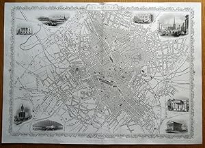
Antique Map BIRMINGHAM, ENGLAND Street Plan RAPKIN & TALLIS original illustrated map c1850
Vendeur : Lindisfarne Prints, Shrewsbury, SHROP, Royaume-Uni
Évaluation du vendeur 5 sur 5 étoiles

Carte
EUR 112,09
Autre deviseEUR 12,60 expédition depuis Royaume-Uni vers Etats-UnisQuantité disponible : 1 disponible(s)
Ajouter au panierAntique MapBIRMINGHAMBy John Rapkin.Drawn & engraved by John Rapkin for "The Illustrated Atlas and Modern History of the World" by Montgomery Martin.Published London circa 1850 by The London Printing and Publishing Company.An attractive and highly detailed double page street plan of Birmingham. Beautifully illustrated with vignette engravings of St.Philip's Church, The London & North Western Railway Station, Town hall, School of Design, Bull Ring, King Edward's School, Theatre Royal and a view of Birmingham from Highgate.The impressive level of detail includes naming of important streets and places of interest which can be appreciated in the close up images provided. Rapkin's superb illustrated town plans are only included in a minority of the Montgomery Martin atlases and are consequently quite scarce and highly sought after. Fine, clean condition. Free of repairs or restoration.Original uncoloured format.Approx. 20.5" x 14.5" (520mm x 370mm) overall.Printed on heavy grade paper, blank verso, centre fold as issued. John Rapkin was a mapmaker who was concerned with the aesthetic value of his work as well as cartographic content. His fine maps are distinguished by the trademark decorative borders, vignettes and title displays. Rapkin worked in close association with the equally respected publisher John Tallis. The publishing rights of many of the maps passed to The London Printing and Publishing Company circa 1850. A GENUINE ANTIQUE MAP GUARANTEED OVER 150 YEARS OLD FROM LINDISFARNE PRINTSVNFQ515.