
Montant total (1 article articles) :
Destination de la commande :

antique map reading berkshire original (2 résultats)
Commentaires
Passer aux résultats principaux de la recherche
Filtres de recherche
Type d'article
- Tous les types de produits
- Livres (1)
- Magazines & Périodiques (Aucun autre résultat ne correspond ŕ ces critčres)
- Bandes dessinées (Aucun autre résultat ne correspond ŕ ces critčres)
- Partitions de musique (Aucun autre résultat ne correspond ŕ ces critčres)
- Art, Affiches et Gravures (Aucun autre résultat ne correspond ŕ ces critčres)
- Photographies (Aucun autre résultat ne correspond ŕ ces critčres)
- Cartes (1)
- Manuscrits & Papiers anciens (Aucun autre résultat ne correspond ŕ ces critčres)
Etat En savoir plus
- Neuf (Aucun autre résultat ne correspond ŕ ces critčres)
- Comme neuf, Trčs bon ou Bon (Aucun autre résultat ne correspond ŕ ces critčres)
- Assez bon ou satisfaisant (1)
- Moyen ou mauvais (Aucun autre résultat ne correspond ŕ ces critčres)
- Conformément ŕ la description (1)
Reliure
- Toutes
- Couverture rigide (Aucun autre résultat ne correspond ŕ ces critčres)
- Couverture souple (Aucun autre résultat ne correspond ŕ ces critčres)
Particularités
- Ed. originale (Aucun autre résultat ne correspond ŕ ces critčres)
- Signé (Aucun autre résultat ne correspond ŕ ces critčres)
- Jaquette (Aucun autre résultat ne correspond ŕ ces critčres)
- Avec images (1)
- Sans impressions ŕ la demande (2)
Langue (2)
Prix
- Tous les prix
- Moins de EUR 20 (Aucun autre résultat ne correspond ŕ ces critčres)
- EUR 20 ŕ EUR 40
- Plus de EUR 40
Livraison gratuite
- Livraison gratuite ŕ destination de France (Aucun autre résultat ne correspond ŕ ces critčres)
Pays
Evaluation du vendeur
-

Berkshire - Showing Reading - Detailed Map Showing Roads, Towns and the Hundreds Etc - an Original Antique Engraved Map
Date d'édition : 1840
Langue: anglais
Vendeur : K Books Ltd ABA ILAB, York, YORKS, Royaume-Uni
Membre d'association : ABA ILAB PBFA
Évaluation du vendeur 5 sur 5 étoiles

EUR 35,37
Autre deviseEUR 10,13 expédition depuis Royaume-Uni vers FranceQuantité disponible : 1 disponible(s)
Ajouter au panierNo Binding. Etat : Very Good. An original antique engraved map, printed circa 1840. Hand-colouring not contemporary but delicately and expertly executed. Mounted and ready to frame. A fine opportunity to purchase an attractive and decorative map - Berkshire - Showing Reading - Detailed Map Showing Roads, Towns and the Hundreds Etc.
-
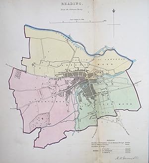
Antique Map READING, BERKSHIRE, Original Street Plan, Dawson 1832
Vendeur : Lindisfarne Prints, Shrewsbury, SHROP, Royaume-Uni
Évaluation du vendeur 5 sur 5 étoiles
Carte
EUR 44,80
Autre deviseEUR 8,58 expédition depuis Royaume-Uni vers FranceQuantité disponible : 1 disponible(s)
Ajouter au panierOriginal Antique Map READING by Robert Kearsley DawsonPublished 1832An original 19th century antique street plan of the town of Reading,Berkshire England. Drawn up by Lieutenant R.K. Dawson of the Royal Engineers and published by the Boundaries Commission in 1832.The whole country was surveyed for the commission to support the 1832 reform bill - a major shake-up of the nation's parliamentary representation.The map is on a scale of 4 inches to the mile affording great detail including individual buildings. It's interesting to compare the 19th century map with the much expanded Reading of the present day.Enhanced with original hand colouring and a colour key to the various boundaries and wards.Fine condition other than some light age toning, free of repairs or restoration.Fold line as issued, blank verso.Approx. 12" x 11" (030mm x 280mm) overall (as depicted).A GENUINE ORIGINAL ANTIQUE MAP GUARANTEED OVER 180 YEARS OLD FROM LINDISFARNE PRINTSNM C 11 22We do not deal in reproductions, facsimiles or modern copies of any kind. .
