Montant total (1 article articles) :
Destination de la commande :

arragonia regnum de blaeu willem janszoon (2 résultats)
Commentaires
Passer aux résultats principaux de la recherche
Filtres de recherche
Type d'article
- Tous les types de produits
- Livres (Aucun autre résultat ne correspond ŕ ces critčres)
- Magazines & Périodiques (Aucun autre résultat ne correspond ŕ ces critčres)
- Bandes dessinées (Aucun autre résultat ne correspond ŕ ces critčres)
- Partitions de musique (Aucun autre résultat ne correspond ŕ ces critčres)
- Art, Affiches et Gravures (Aucun autre résultat ne correspond ŕ ces critčres)
- Photographies (Aucun autre résultat ne correspond ŕ ces critčres)
- Cartes (2)
- Manuscrits & Papiers anciens (Aucun autre résultat ne correspond ŕ ces critčres)
Etat En savoir plus
- Neuf (Aucun autre résultat ne correspond ŕ ces critčres)
- Comme neuf, Trčs bon ou Bon (1)
- Assez bon ou satisfaisant (1)
- Moyen ou mauvais (Aucun autre résultat ne correspond ŕ ces critčres)
- Conformément ŕ la description (Aucun autre résultat ne correspond ŕ ces critčres)
Reliure
- Toutes
- Couverture rigide (Aucun autre résultat ne correspond ŕ ces critčres)
- Couverture souple (1)
Particularités
- Ed. originale (Aucun autre résultat ne correspond ŕ ces critčres)
- Signé (Aucun autre résultat ne correspond ŕ ces critčres)
- Jaquette (Aucun autre résultat ne correspond ŕ ces critčres)
- Avec images (2)
- Sans impressions ŕ la demande (2)
Langue (2)
Prix
- Tous les prix
- Moins de EUR 20 (Aucun autre résultat ne correspond ŕ ces critčres)
- EUR 20 ŕ EUR 40 (Aucun autre résultat ne correspond ŕ ces critčres)
- Plus de EUR 40
Livraison gratuite
- Livraison gratuite ŕ destination de Etats-Unis (Aucun autre résultat ne correspond ŕ ces critčres)
Pays
Evaluation du vendeur
-
![Image du vendeur pour [Mapa de Aragón] Arragonia Regnum mis en vente par Bolivar Old Prints Anticuario](https://pictures.abebooks.com/inventory/md/md32007402304.jpg)
[Mapa de Aragón] Arragonia Regnum
Edité par Amsterdam, 1643
Vendeur : Bolivar Old Prints Anticuario, Barcelona, B, Espagne
Membre d'association : AILA ILAB
Évaluation du vendeur 4 sur 5 étoiles

Carte
EUR 450
Autre deviseEUR 25 expédition depuis Espagne vers Etats-UnisQuantité disponible : 1 disponible(s)
Ajouter au panierSin Encuadernar - No binding. Etat : Bueno. Mapa de Aragón Joao Baptista Lavanha [Labańa], c. 1642. Muestra la imagen más antigua de Aragón, dibujada con procedimientos científicos de su época. En el siglo XVII, las autoridades ibéricas se apresuraron a editar mapas modernos de sus reinos, pues ya no confiaban en la información de segunda mano ni estaban satisfechas con la cartografía peninsular de finales del siglo XVI realizada por Pedro Esquivel. Ya en 1613-1614, el cartógrafo Juan Baptista Labańa (conocido tambien por su nombre portugés Joăo Baptista Lavanha), por encargo del Reino de Aragón, había terminado de cartografiar su territorio. Este mapa de Lavańa ofrece al viajero una visión más precisa de la ubicación de las montańas y ríos de Aragón. La plancha original del mapa fue producida hacia 1620 en Madrid, y las copias posteriores se derivaron de ella. Aunque hace hincapié en las jurisdicciones eclesiásticas, el mapa se centra en Zaragoza y se extiende hasta Calahorra y Cuenca al oeste, Pamplona al norte y Lérida al este. Una cartela rematada por un escudo de armas encierra el título del mapa y una inscripción en latín. En una segunda cartela, rematada por un escudo de armas, figura una mención dedicatoria a Gaspari Charles. Hay seis escudos de armas repartidos por el mapa. Escala en una cartela en la parte superior del mapa. Grabado orignal en cobre, iluminado a mano. ------------------------------------------------------- A hand-coloured map of Aragon by Joao Baptista Lavanha [Labanna], [1642?] 17th century. The map shows the oldest image of Aragon, drawn using scientific procedures of its time. In the 17th century, the Iberian authorities raced to issue modern maps of their realms, as they no longer relied on second-hand information or were no more satisfied with the peninsula's late 16th-century mapping by Pedro Esquivel. As soon as 1613-1614, Portuguese cartographer Lavanha, commissioned by Aragon, had finished mapping their kingdom. This map from Lavanha gives the traveller a better view of the lie of the mountains and rivers in Aragon. The map's original plate was produced circa 1620 in Madrid, and subsequent copies were derived from it. While emphasizing ecclesiastical jurisdictions, the map is centered around Zaragoza, extending to Calahorra and Cuenca in the west, Pamplona in the north, and Lerida in the east. A cartouche capped by a coat of arms encloses the map's title and a Latin inscription. A dedicatory mention to Gaspari Charles is enshrined in a second cartouche topped by a coat of arms. Six coats of arms are scattered across the map. Scale in a cartouche in the upper part of the map. FRA. Excellent.
-
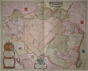
Arragonia Regnum. Auctore Joanne Baptista Labanna
Langue: allemand
Vendeur : Kunstantiquariat Andreas Senger, Hamburg, Allemagne
Évaluation du vendeur 4 sur 5 étoiles
Carte
EUR 599
Autre deviseEUR 35 expédition depuis Allemagne vers Etats-UnisQuantité disponible : 1 disponible(s)
Ajouter au panierKein Einband. Etat : Gut bis sehr gut. Es handelt sich hierbei um eine originale, altkolorierte Kupferstich-Landkarte des Gebiets des Königreichs Aragonien von Willem Janszoon Blaeu (1571 - 1638) aus dem Jahr 1645. *** Titel: Arragonia Regnum. Auctore Joanne Baptista Labanna *** Gebiet bzw. Ort: Krone von Aragonien - Königreich von Aragonien *** Kartograph: Willem Janszoon Blaeu (1571 - 1638) *** Jahr: 1645 *** Größe des Plattenbereichs: 41 x 51 cm *** Technik: Kupferstich *** Zustand (Perfekt/ Sehr gut/ Gut/ Ordentlich/ Mäßig/ Schlecht): In sehr gutem Erhaltungszustand *** Bemerkungen: Seltene Karte in dekorativem Altkolorit - - - International buyers welcome. If you have any questions, please don't hesitate to ask. - - - Spain Crown of Aragon ----- Auf Wunsch stellen wir Ihnen gerne ein kostenfreies Echtheitszertifikat aus ------ If you wish, we will gladly provide a certificate of authenticity free of charge ---.