Montant total (1 article articles) :
Destination de la commande :

atlas historique de chatelain, Ancien ou d'occasion (49 rťsultats)
Commentaires
Passer aux rťsultats principaux de la recherche
Filtres de recherche
Type d'article
- Tous les types de produits
- Livres (22)
- Magazines & Pťriodiques (Aucun autre rťsultat ne correspond ŗ ces critŤres)
- Bandes dessinťes (Aucun autre rťsultat ne correspond ŗ ces critŤres)
- Partitions de musique (Aucun autre rťsultat ne correspond ŗ ces critŤres)
- Art, Affiches et Gravures (10)
- Photographies (Aucun autre rťsultat ne correspond ŗ ces critŤres)
- Cartes (17)
- Manuscrits & Papiers anciens (Aucun autre rťsultat ne correspond ŗ ces critŤres)
Etat En savoir plus
Reliure
- Toutes
- Couverture rigide (7)
- Couverture souple (Aucun autre rťsultat ne correspond ŗ ces critŤres)
Particularitťs
- Ed. originale (1)
- Signť (Aucun autre rťsultat ne correspond ŗ ces critŤres)
- Jaquette (Aucun autre rťsultat ne correspond ŗ ces critŤres)
- Avec images (43)
- Sans impressions ŗ la demande (49)
Langue (3)
Livraison gratuite
- Livraison gratuite ŗ destination de France (Aucun autre rťsultat ne correspond ŗ ces critŤres)
Pays
Evaluation du vendeur
-
Atlas historique, ou, Nouvelle introduction a l'histoire, a? la chronologie & a? la ge?ographie ancienne & moderne: Repre?sente -Language: french
Vendeur : GreatBookPrices, Columbia, MD, Etats-Unis
…valuation du vendeur 5 sur 5 ťtoiles

EUR 36,39
Autre deviseEUR 17,25 expťdition depuis Etats-Unis vers FranceQuantitť disponible : Plus de 20 disponibles
Ajouter au panierEtat : As New. Unread book in perfect condition.
Plus de choix d'achat de la part d'autres vendeurs sur AbeBooks
Offres d'occasion ŗ partir de EUR 53,64
Trouvez ťgalement Couverture rigide
-

Sammlung von 4 Tafeln, 1 Karte und 13 S.Text zur Schweiz aus: Atlas historique.
Editť par Amsterdam, ohne Verlag, um 1710., 1710
Langue: franÁais
Vendeur : Antiquariat Gerber AG, ILAB/VEBUKU/VSAR, Basel, Suisse
Membre d'association : ILAB VEBUKU
…valuation du vendeur 4 sur 5 ťtoiles

EUR 550
Autre deviseEUR 20 expťdition depuis Suisse vers FranceQuantitť disponible : 1 disponible(s)
Ajouter au panier22 Bl. Mit 4 doppelblgr.Kpf.-Taf.und 1 mehrfach gefalteten Kpf.-Karte. Ršnder stellenweise berieben, Ecken bestossen; Tafeln und Text durchgehend leicht gebršunt, Karte sehr frisch. Ferienhalber sind wir bis zum 12.August abwesend --- We are absent until the 12th of August due to holidays. Sprache: FranzŲsisch Gewicht in Gramm: 0 Fol. Pappband d.Zeit mit Buntpapierbezug.
-
Atlas Historique, ou Nouvelle introduction a l'histoire, ŗ la chronologie & ŗ la gťographie ancienne & moderne; reprťsentťe dans de nouvelles cartes, oý remarque l'ťtablissement des Etats & Empires du Monde, leur durťe, leur chute, & leurs differens Gouvernemens; la Chronologie des Consuls Romains, des Papes, des Empereurs, des Rois & des Princes, & c. qui ont ťtť depuis le commencement du Monde, jusqu'ŗ prťsent: et la Gťnealogie des Maisons Souveraines de l'Europe. Par Mr. C. *** avec dissertations sur l'Histoire de chaque Etat par Mr. Gueudeville.
Editť par FranÁois L'Honorť & Compagnie, Amsterdam, 1705
Langue: franÁais
Vendeur : BALAGU… LLIBRERIA ANTIQUARIA, Santa Coloma de Farners, GI, Espagne
Membre d'association : AILA ILAB
…valuation du vendeur 5 sur 5 ťtoiles
EUR 8†000
Autre deviseEUR 20 expťdition depuis Espagne vers FranceQuantitť disponible : 1 disponible(s)
Ajouter au panierMedia Piel …poca. Etat : Muy bien. Primera ediciůn. 44 x 29 cm. Frontis grabado - Portada grabada y a dos tintas - 1 h. con gran escudo herŠldico - 3 h. - 1 lŠmina con el Plano de la Ville de Landaw y planos de distintas batallas de 1704 - 2 h. de průlogo - 2 h. - una gran lŠmina doble y plegada con genealogŪa y escudos herŠldicos - 8 pp. - 1 lŠmina doble con las esferas terrestres y celestes - 1 mapa doble del Globo terrestre - 2 h. - 1 lŠmina doble - 1 mapa doble con la esfera terrestre - 1 mapa doble con los Imperios - 2 h. - 8 pp. - 1 mapa doble de Grecia - 1 mapa doble del mar MediterrŠneo - 1 lŠmina doble dedicada a Grecia - 2 h. - 16 pp. - 1 mapa doble de Italia - 1 mapa doble de Europa - 1 plano doble de Roma con la situaciůn de los monumentos - 8 h. - 1 lŠmina doble con todos los retratos de reyes y emperadores - 6 h. - 14 pp. - 1 mapa doble y plegado de Italia coloreado a mano - 1 plano doble de Roma - 4 h. - 1 lŠmina doble - 1 plano de Roma doble - 16 pp. - 1 mapa doble y plegado de Francia, coloreado a mano - 1 lŠmina doble con herŠldica - 1 lŠmina doble con retratos de reyes - 1 lŠmina doble con los blasones franceses - 1 lŠmina doble con distintas imŠgenes de gobernaciůn - 1 lŠmina doble con efectos militares - 4 h. - 8 pp. - 1 mapa doble y plegado de EspaŮa, coloreado a mano - 1 lŠmina doble con los retratos de los reyes espaŮoles - 1 lŠmina doble con distintas vistas espaŮolas - 1 lŠmina doble con distintas imŠgenes gubernamentales - 1 mapa doble con EspaŮa, Canarias, Mťxico, Perķ, Italia, Las Antillas, Las Filipinas. , coloreado a mano - 1 lŠmina doble con una pequeŮo mapa de Amťrica y escenas gubernamentales - 6 h. - 8 pp. - 1 mapa doble y plegado de los Paises Bajos, coloreado a mano - 1 lŠmina doble con retratos de reyes y clťrigos - 1 lŠmina doble con retratos de personajes ilustres - 2 lŠmina doble con escenas gubernamentales - 1 mapa doble del Mundo, iluminado a mano - y - 6 h. =Ejemplar en muy buen estado de conservaciůn encuadernado a media piel con puntas. Cortes pintados. Excellent frontispice - Couverture ŗ deux encres - 1 h. avec un grand blason hťraldique - 3 h. - le Plan de la Ville de Landaw et des plans de diverses batailles de 1704 - 2 h. avant-propos - 2 h. - 1 grande planche doublement pliťe avec gťnťalogie et boucliers hťraldiques - 8pp. - 1 double plaque avec les sphŤres terrestre et cťleste - 1 double carte du globe terrestre - 2 h. - 1 double plaque - 1 double carte avec la sphŤre terrestre - 1 double carte avec les Empires - 2 h. - 8 pages. - 1 carte double de la GrŤce - 1 carte double de la mer Mťditerranťe - 1 plaque double dťdiťe ŗ la GrŤce - 2 h. - 16 pages. - 1 double carte d'Italie - 1 double carte d'Europe - 1 double carte de Rome avec la situation des monuments - 8 h. - 1 double plaque avec tous les portraits des rois et empereurs - 6 h. - 14pp. - 1 double plan pliť de l'Italie, coloriť ŗ la main - 1 double plan de Rome - 4 h. - 1 double planche - 1 double plan de Rome - 16 pp. - 1 double carte de France pliťe, coloriťe ŗ la main - 1 double planche d'hťraldique - 1 double planche de portraits de rois - 1 double planche d'armoiries franÁaises - 1 double planche d'images diverses de gouvernorat - 1 double planche d'effets militaires - 4 h. - 8 pages. - 1 double carte pliťe de l'Espagne, colorťe ŗ la main - 1 double feuille avec les portraits des rois espagnols - 1 double feuille avec diffťrentes vues espagnoles - 1 double feuille avec diffťrentes images gouvernementales - 1 double carte avec l'Espagne, les Óles Canaries, le Mexique, le Pťrou, l'Italie, les Antilles, les Philippines. coloriťe ŗ la main - 1 double planche avec une petite carte de l'Amťrique et des scŤnes gouvernementales - 6 h. - 8 pages. - 1 double carte dťpliante des Pays-Bas, coloriťe ŗ la main - 1 double planche de portraits de rois et de clercs - 1 double planche de portraits de personnages illustres - 2 doubles planches de scŤnes gouvernementales - 1 double carte du Monde, ťclairťe ŗ la main - et - 6 h.
-
An antique copper plate map of the United Kingdom and Ireland by Henri Chatelain, inset within French text by Nicholas Gueudevielle covering military information pertaining to British/English forces in 1704. Taken from†Atlas Historique†by Henri Chatelain
Editť par Chez Zacharie Ch‚telain, 1705
Langue: anglais
Vendeur : GN Books and Prints, Inverness, Royaume-Uni
…valuation du vendeur 4 sur 5 ťtoiles
Carte
EUR 120,49
Autre deviseEUR 10,55 expťdition depuis Royaume-Uni vers FranceQuantitť disponible : 1 disponible(s)
Ajouter au panierNo Binding. Etat : As Described. No Jacket. Henri Chatelain (illustrateur). An antique copper plate map of the United Kingdom and Ireland by Henri Chatelain, inset within French text by Nicholas Gueudevielle covering military information pertaining to British/English forces in 1704 Taken from Atlas Historique by Henri Chatelain (1684 - 1743), published in seven volumes, four editions being published during his lifetime, between 1705 and 1739 Likely published by Chez Zacharie Ch‚telain, Amsterdam This map comprises plate no 52 from book 2 and is headed "CARTE DU GOUVERNEMENT MILITAIRE D'ANGLETERRE OU L'ON REPRESENTE L'ETAT DES OFFICIERS DE GUERRE ET CELUI DES FORCES DE TERRE ET DE MER", translating as "MAP OF THE MILITARY GOVERNMENT OF ENGLAND SHOWING THE STATUS OF THE WAR OFFICERS AND THAT OF THE LAND AND SEA FORCES" The map contains two classical images on either side of the map and there is a considerable volume of text below, providing information including the military makeup of the British forced in 1704, listing the numbers of troops, materiel, officers, etc Measures around 21 1/4" x 17 1/2" (540mm x 450mm) The map contains one central vertical fold There are signs of wear, a little creasing to upper corners, though no loss, except to binding tape rear A little marking and minimal light foxing but quite clean for age See pictures for further information 1 pp c. 1705-1739. n.
-
An antique copper plate map of England and Wales by Henri Chatelain and map of London, inset within French text by Nicholas Gueudevielle covering military information pertaining to England and London. Taken from†Atlas Historique†by Henri Chatelain.
Editť par Chez Zacharie Ch‚telain, 1705
Langue: anglais
Vendeur : GN Books and Prints, Inverness, Royaume-Uni
…valuation du vendeur 4 sur 5 ťtoiles
Carte
EUR 120,49
Autre deviseEUR 10,55 expťdition depuis Royaume-Uni vers FranceQuantitť disponible : 1 disponible(s)
Ajouter au panierNo Binding. Etat : As Described. No Jacket. Henri Chatelain (illustrateur). An antique copper plate map of England and Wales by Henri Chatelain and map of London, inset within French text by Nicholas Gueudevielle covering military information pertaining to England and London Taken from Atlas Historique by Henri Chatelain (1684 - 1743), published in seven volumes, four editions being published during his lifetime, between 1705 and 1739 Likely published by Chez Zacharie Ch‚telain, Amsterdam This map comprises plate no 53 from book 2 and is headed "NOUVELLE CARTE DU GOUVERNEMENT CIVIL D'ANGLETERRE ET DE CELUY DE LA VILLE DE LONDRES", translating as "NEW MAP OF THE CIVIL GOVERNMENT OF ENGLAND AND THAT OF THE CITY OF LONDON" The map contains two classical images on either side of the map and there is a considerable volume of text below, providing information on the government of England and London Measures around 21 1/4" x 17 1/2" (540mm x 450mm) The map contains one central vertical fold There are signs of wear, a little creasing to upper corners, though no loss, except to binding tape rear A little marking and minimal light foxing but quite clean for age See pictures for further information 1 pp c. 1705-1739. n.
-

Carte de l'etat de la cour Imperiale et des etats Hereditaires De La Maison D'Autriche avec Leurs diverses chanceleries. Carte de la etats de la dependance de sa maieste Imperiale et des anciens comtes d'Habsbourg. Tome 2. No. 30. (to accompany) Atlas Historique . Tome II. Premiere partie. carte des etates de la dependance de sa maieste imperiale et des anciens comtes d' habsbourg.
Editť par Freres Chatelain, Amsterdam., 1720
Langue: franÁais
Vendeur : Antiquariat im Schloss, Schwaigern, D, Allemagne
…valuation du vendeur 5 sur 5 ťtoiles
EUR 147
Autre deviseEUR 19,90 expťdition depuis Allemagne vers FranceQuantitť disponible : 1 disponible(s)
Ajouter au panier1 Blatt, 52 x 44 cm, Druck 47, 5 x 38,5 cm. Ršnder leicht angerissen, etwas nachgedunkelt, Mittelfalz, Druck guter Zustand. Sprache: FranzŲsisch Gewicht in Gramm: 900.
-
Atlas Historique, ou nouvelle introduction ŗ l'histoire, Tome 6, Afrique seul
Editť par Chez l'Honorť et Chatelain, 1719
Vendeur : Librairie Voyage et Exploration, Cerny, France
…valuation du vendeur 5 sur 5 ťtoiles
Edition originale
EUR 1†300
Autre deviseEUR 10 expťdition vers FranceQuantitť disponible : 1 disponible(s)
Ajouter au panierCouverture rigide. Etat : Bon. Edition originale. Amsterdam, Chez l'Honorť et Chatelain, 1719, in-folio, 1f.-IV-2ff.-74pp., titre en rouge et noir avec 20 gravures sur cuivre ŗ double pages, comprenant les 3 cartes de l'Afrique, tableaux et descriptions des diffťrents pays et peuples, reliť plein percale, ex-libris Karl-Ferdinand Schšdler, Ethnologue et ťconomiste, spťcialiste d'art africain, frottements, coiffes et coins usťs. Partie de l'Afrique seule, en ťdition originale et complŤte en elle-mÍme du cťlŤbre ouvrage de Henri Chatelain avec les dissertations de Nicolas Gueudeville. On y trouve les descriptions de l'…gypte, Barbarie, Nigritie, Guinťe, Ethiopie, Congo et le Cap de Bonne Espťrance, ainsi que les 3 cartes ŗ double pages, dont la ę Carte particuliŤre de l'…gypte, de la Nubie et de l'Abyssinie Ľ, ę Carte de la Barbarie, Nigritie et de la Guinťe Ľ, ę Carte du Royaume de Congo, du Monomotapa et de la Cafrerie Ľ basťes sur celles de Guillaume De l'Isle, montrant les royaumes, peuples et productions ťconomiques. Ouvrage ambitieux et joliment prťsentť, l'Atlas Historique ťtait destinť au grand public, fascinť au dťbut du XVIIIe siŤcle par les pays rťcemment explorťs et les nouvelles dťcouvertes, outre les cartes, les planches reprennent les meilleurs rťcits de voyage de l'ťpoque, comme ceux de Dapper, Chardin, de Bruyn, Le Hay et autres.
-
Atlas Historique, Tome Premier / Atlas Historque Tome II.
Editť par Artist: Chatelain Henri Abraham ( - 1743 ) Amsterdam; issued in: Amsterdam; - Henri Abraham Chatelain (1684 - 1743) was a Huguenot pastor of Parisian origins He lived consecutively in Paris St Martins London (c 1710) The Hague (c 1721) and Amsterdam (c 1728) He is best known as a Dutch cartographer and more specifically for his cartographic contribution in the seminal seven volume Atlas Historique published in Amsterdam between 1705 and 1720 Innovative for its time the Atlas Historique combined fine engraving and artwork with scholarly studies of geography history ethnology heraldry and cosmography Some scholarship suggests that the Atlas Historique was not exclusively compiled by Henri Chatelain as is commonly believed but rather was a fam, 1684
Vendeur : Antique Sommer& Sapunaru KG, MŁnchen, Allemagne
Membre d'association : ILAB VDA
…valuation du vendeur 4 sur 5 ťtoiles
EUR 6†650
Autre deviseEUR 25 expťdition depuis Allemagne vers FranceQuantitť disponible : 1 disponible(s)
Ajouter au panierTechnic: Copper print, colorit: black/whitecondition: Binding in hardcover with leather embossed in gold, minor damage, size (in cm): 45,5 x 29 cm cm; - Two atlases Historique, Tome I and Tome II published by L'Honore and Chatelain, Amsterdam 1720 and 1721, with notes on the history of each state, by Mr Gueudeville. Atlant Tome I with 82 pages of text and 47 plates (plates 41 and 46 are missing) including 12 folding maps such as the whole world, Europe, Asia, Africa, South America, North America, Spain and many family trees of European countries. On double pages are e.g. a plan of Rome, the ancient world, Greece, world with two hemispheres, a map of the sky and much more. Atlant Tome II with 90 text pages and 41 plates including 9 folding maps with family trees of Brandenburg, Nassau, Saxony, the Austrian royal house and maps of Bohemia, Hungary, Germany, etc. Both atlases open with splendidly coloured title pages.
-

ATLAS HISTORIQUE, or Nouvelle Introduction a l'Histoire, a la Chronologie & a la Geographie Ancienne & Moderne; Tome II, Seconde Partie, ou Tome III' of the 'Nouvelle Edition
Editť par Zacherie Chatelain, Amsterdam, 1737
Vendeur : BISON BOOKS - ABAC/ILAB, Winnipeg, MB, Canada
Membre d'association : ABAC ILAB
…valuation du vendeur 4 sur 5 ťtoiles
EUR 3†261,76
Autre deviseEUR 37,97 expťdition depuis Canada vers FranceQuantitť disponible : 1 disponible(s)
Ajouter au panierLeather Bound. Tall folio. Bound in full contemporary calf, with seven raised bands and the spine ornamented in gilt. The binding shows minor wear but is otherwise strong and the contents are in remarkable condition. There is an elaborate engraved plate preceding the formal title page (printed in red and black). Measures 47 x 29.5 cms. Zacherie Chatelain (d.1723) was the father of Henri Abraham (1684-1743) and Zacherie Junior (1690-1754). They worked as a partnership publishing this atlas under several different Chatelain imprints, depending on the Chatelain family partnerships at the time of publication. The original atlas was published in seven volumes between 1705 and 1720, with a second edition appearing in 1732. The maps were accompanied by information pertaining to cosmography, geography, history, chronology, genealogy, topography, heraldry, and costume of the world. The maps in the Atlas Historique were based on those of the French cartographer Guillaume De L'Isle, but were presented by the Chatelains in an encyclopedic format. The text is in French and is printed in two columns on the page with maps and other illustrations interspersed. Each map and table is numbered consecutively (see MapHist dot com). Our offering is described as 'Tome II, Seconde Partie, ou Tome III' of the 'Nouvelle Edition' which has been 'Revue, corrigee, & considerablement augumentee'. It covers Great Britain, Ireland, Switzerland, Savoy, Lorraine, and the Republic of Venice. It contains 26 folding maps, and ten genealogical tables or charts.
-
ATLAS HISTORIQUE TOME 7: TITLE PAGE
Editť par Chatelain, Amsterdam, 1721
Vendeur : Hornseys, Ripon, Royaume-Uni
Membre d'association : PBFA
…valuation du vendeur 5 sur 5 ťtoiles
EUR 88,61
Autre deviseEUR 28,68 expťdition depuis Royaume-Uni vers FranceQuantitť disponible : 1 disponible(s)
Ajouter au panierNo Binding. Etat : Very Good. Reprint. Date: 1721. Copper engraving. Sheet size: 44.1cm x 27.7cm with good margins. Private library stamp to margin, slightly affecting the engraving. Highly embellished. A fine, strong impression. Some minor creasing, dustiness and age toning else in very good, bright, clean condition. Very scarce.
-
ATLAS HISTORIQUE TOME II: TITLE PAGE
Editť par Chatelain, Amsterdam, 1739
Vendeur : Hornseys, Ripon, Royaume-Uni
Membre d'association : PBFA
…valuation du vendeur 5 sur 5 ťtoiles
EUR 88,61
Autre deviseEUR 28,68 expťdition depuis Royaume-Uni vers FranceQuantitť disponible : 1 disponible(s)
Ajouter au panierNo Binding. Etat : Very Good. Reprint. Date: 1739. Copper engraving. Sheet size: 44.1cm x 27.7cm with good margins. Private library stamp to margin, not affecting the engraving. Highly embellished. A fine, strong impression. Some minor creasing, dustiness and age toning else in very good, bright, clean condition. Very scarce.
-
ATLAS HISTORIQUE TOME I: TITLE PAGE
Editť par Chatelain & Zacharie Librarie, Amsterdam, 1739
Vendeur : Hornseys, Ripon, Royaume-Uni
Membre d'association : PBFA
…valuation du vendeur 5 sur 5 ťtoiles
EUR 88,61
Autre deviseEUR 28,68 expťdition depuis Royaume-Uni vers FranceQuantitť disponible : 1 disponible(s)
Ajouter au panierNo Binding. Etat : Very Good. Reprint. Date: 1739. Copper engraving. Sheet size: 44.1cm x 27.7cm with good margins. Private library stamp to margin, not affecting the engraving. Highly embellished. A fine, strong impression. Some minor creasing, dustiness and age toning else in very good, bright, clean condition. Very scarce.
-
ATLAS HISTORIQUE TOME IV: TITLE PAGE
Editť par Chatelain, Amsterdam, 1739
Vendeur : Hornseys, Ripon, Royaume-Uni
Membre d'association : PBFA
…valuation du vendeur 5 sur 5 ťtoiles
EUR 88,61
Autre deviseEUR 28,68 expťdition depuis Royaume-Uni vers FranceQuantitť disponible : 1 disponible(s)
Ajouter au panierNo Binding. Etat : Very Good. Reprint. Date: 1739. Copper engraving. Sheet size: 44.1cm x 27.7cm with good margins. Private library stamp to margin, not affecting the engraving. Highly embellished. A fine, strong impression. Some minor creasing, dustiness and age toning else in very good, bright, clean condition. Very scarce.
-

Atlas Historique Tome II
Editť par Chatelain frontespizio II vol
Vendeur : Sergio Trippini, Gavirate, VA, Italie
Membre d'association : ALAI ILAB
…valuation du vendeur 4 sur 5 ťtoiles
EUR 100
Autre deviseEUR 23 expťdition depuis Italie vers FranceQuantitť disponible : 1 disponible(s)
Ajouter au panierStampa, antica ed originale, frontespizio del II Tomo "Atlas Historique ou nouvelle introduction a l'Histoire, ŗ la Chronologie & ŗ la Geographie Ancienne & Moderne?", pubblicato ad Amsterdam nel 1708. Atlante che, con la sua pubblicazione, coniuga le mappe geografiche con incisioni e informazioni di carattere geografico, araldico, etnografico e storico cosž rendendo l'opera in sette volumi molto innovativa. Dimensione385x230 mm.Henri Abraham Chatelain (1684 - 1743), pastore ugonotto originario di Parigi visse alternativamente a Parigi, Londra, L'Aia ed Amsterdam. Conosciuto come cartografo olandese per il sua opera cartografica monumentale in sette volumi "Atlas Historique" pubblicata ad Amsterdam con i suoi fratelli.
-

Supplťment ŗ L'Atlas historique, contenant diverses piťces de Chronologie, d'Histoire & d'autres Sciences . Tome VII. et dernier.
Editť par Amsterdam: L'Honorť & Ch‚telain ,, 1720
Vendeur : Antiquariat Ruthild Jšger, Lueneburg, Allemagne
Membre d'association : ILAB VDA
…valuation du vendeur 2 sur 5 ťtoiles

EUR 120
Autre deviseEUR 20 expťdition depuis Allemagne vers FranceQuantitť disponible : 1 disponible(s)
Ajouter au panierGr.-2į. 1 Blatt in Rot und Schwarz (28 x 44 cm. ungefaltet). Sehr gut erhalten / in very good state of conservation. * Titelblatt zu Ch‚telains berŁhmtem "Atlas historique" (hier: der 7. und letzte Band), mit hŁbscher Titelvignette von Picart, dat. 1719. Mit 2 Beigaben: 1. groŖes und dekoratives allegorisches Kupferstich-Titelblatt zum Atlas; 2. Inhaltsverzeichnis zu Band 7 (Table du supplťment ŗ l'Atlas historique); am SchluŖ dreisprachige Hinweise fŁr den Buchbinder: au relieur, aen den Boekbinder, an den Buchbinder.
-

Atlas Historique
Editť par Chatelain Atlas - Frontespizio Tomo I
Vendeur : Sergio Trippini, Gavirate, VA, Italie
Membre d'association : ALAI ILAB
…valuation du vendeur 4 sur 5 ťtoiles
EUR 120
Autre deviseEUR 23 expťdition depuis Italie vers FranceQuantitť disponible : 1 disponible(s)
Ajouter au panierStampa, antica ed originale, raffigurante il frontespizio del I Tomo "Atlas Historique ou nouvelle introduction a l'Histoire, ŗ la Chronologie & ŗ la Geographie Ancienne & Moderne?", pubblicato ad Amsterdam nel 1713. Atlante che, con la sua pubblicazione, coniuga le mappe geografiche con incisioni e informazioni di carattere geografico, araldico, etnografico e storico cosž rendendo l'opera in sette volumi molto innovativa. Insisione di mm 390x237.Henri Abraham Chatelain (1684 - 1743), pastore ugonotto originario di Parigi visse alternativamente a Parigi, Londra, L'Aia ed Amsterdam. Conosciuto come cartografo olandese per il sua opera cartografica monumentale in sette volumi "Atlas Historique" pubblicata ad Amsterdam con i suoi fratelli.
-
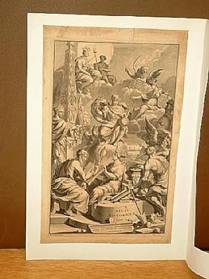
Titelkupfer aus: Atlas Historique, ou Nouvelle Introduction A l"Histoire, ŗ la Chronologie & ŗ la Geographie Ancienne & Moderne; Reprťsentťe dans de Nouvelles Cartes, Oý l"on remarque l"ťtablissemant des Etats & Empires du Monde.Tome II.
Editť par Zacharias Chatelain, Amsterdam
Vendeur : Antiquariat Friederichsen, Hamburg, Allemagne
Membre d'association : BOEV
…valuation du vendeur 5 sur 5 ťtoiles
Art / Affiche / Gravure
EUR 150
Autre deviseEUR 15 expťdition depuis Allemagne vers FranceQuantitť disponible : 1 disponible(s)
Ajouter au panierHier nur das Titelkupfer zu dem um 1720 herum erschienenem zweiten Band des *Atlas Historique*, gestochen von Sluyter. BildgrŲŖe: 38,5 x 23 cm ( HŲhe x Breite ), BlattgrŲŖe: 43 x 26,5 cm. Das Blatt stark gebršunt, in der Darstellung geringfŁgig stockfleckig im oberen Bereich, der BlattauŖenrand stšrker fleckig und fingerfleckig sowie mit Randlšsionen und Einrissen vor allem am oberen Rand ( Einrisse teils hinterlegt ). Das Blatt unter schlichtem Passepartout montiert. ( Pic erhšltlich // webimage available ).
-
ATLAS HISTORIQUE TOME V: TITLE PAGE
Editť par Chatelain, Amsterdam, 1732
Vendeur : Hornseys, Ripon, Royaume-Uni
Membre d'association : PBFA
…valuation du vendeur 5 sur 5 ťtoiles
EUR 147,68
Autre deviseEUR 28,68 expťdition depuis Royaume-Uni vers FranceQuantitť disponible : 1 disponible(s)
Ajouter au panierNo Binding. Etat : Very Good. Reprint. Date: 1732. Copper engraving. Sheet size: 44.1cm x 27.7cm with good margins. Private library stamp to margin, slightly affecting the engraving. Highly embellished. A fine, strong impression. Some minor creasing, dustiness and age toning else in very good, bright, clean condition. Very scarce.
-
Carte Ancienne et Moderne de l'Irlande. Avec Quelques Remargues Sur Sn Gouvernement et Sur L'Etat Present de cette Isle. [Title across the top above neat line, The map is framed on both sides by columns of engraved text. There is a single scale towards the bottom right. In the top right corner in frame box is Tome 2 / Nro. 57. And outside the margin, bottom centre is the impirnt Avec Privilege de Nos Seigneurs les Etats de Hollande et Westrise The map shows the ancient names. From: Henri Abraham Chatelain's "Atlas Historique." (Vol. 2)
Editť par Amsterdam. Chez les Freres Chatelain. 1709, 1709
Vendeur : J. Patrick McGahern Books Inc. (ABAC), Ottawa, ON, Canada
Membre d'association : ABAC ILAB IOBA
…valuation du vendeur 4 sur 5 ťtoiles
EUR 516,10
Autre deviseEUR 16,40 expťdition depuis Canada vers FranceQuantitť disponible : 1 disponible(s)
Ajouter au panierNo Binding. Etat : Fine. 45x 53cm, 17.75"x 20.75", (image 35.5x 6). on plate 35.5cm x 46cm(13in x 18in), a fine bright copy, rare Bonar Law. #46. p90. The copper-plate maps from Chatelain's "Atlas Historique" (1705-1720) are based on the work of French cartographer, Guillaume De L'Isle. Tables include ancient peoples, places, etc. The maps shows the ancient names.
-
Atlas Historique, Ou Nouvelle Introduction A l'Histoire, ŗ la Chronologie & ŗ la Geographie Ancienne & Moderne. Reprťsentťe dans de Nouvelles Cartes, Oý l'on remarque l'Etablissement des Etats & Empires du Monde, leur durťe, leur chŻte, & leurs differens Gouvernemens; La Chronologie des Consuls Romains, des Papes, des Empereurs, des Rois, & des Princes, &c. qui ont ťtť depuis le commencement du Monde, jusqu'ŗ prťsent: Et la Gťnealogie des Maisons Souveraines de l'Europe Tome IV: Qui comprend le Dannemarck, la Suede, la Pologne, la Moscovie, la Turquie, [et]c.
Editť par Amsterdam, FrŤres Ch‚telain., 1714
Vendeur : Antiquariat Peter Fritzen, Speicher, Allemagne
Membre d'association : ILAB VDA
…valuation du vendeur 5 sur 5 ťtoiles
EUR 2†500
Autre deviseEUR 12 expťdition depuis Allemagne vers FranceQuantitť disponible : 1 disponible(s)
Ajouter au panierGroŖ-Folio (45 x 29 cm). Titelblatt in Rot und Schwarz gedruckt. Mit Kupferstich-Frontispiz und 36 teils mehrfach gefalteten Kupfertafen. ZeitgenŲssisches Ganzleder mit zwei roten LederrŁckenschildern und reicher RŁckenvergoldung, Steh- und Innenkantenvergoldung, marmorierte Vorsštze. Einband etwas berieben, bestoŖen und fleckig. Papier teils fleckig und mit Wasserrand. Einzelne Einrisse alt hinterlegt. Insgesamt jedoch sauber und frisch. Wappen-Exlibris. Koeman II, 33-38. Vierter (von sieben) Bšnden des berŁhmten enzyklopšdischen historischen Atlas, mit Beschreibungen, genealogischen Tabellen, Karten und Ansichten. Vollstšndiges Exemplar, kollationiert nach dem eingebundenen Tafelverzeichnis, dekorativ gebunden. Vorliegender Band mit Karten u.a. von Dšnemark, Schweden, Lappland, Polen, Russland und dem TŁrkischen Reich. Eine Kopie des Inhaltsverzeichnisses sende ich Ihnen auf Anfrage gerne zu. Single volume of the famous encyclopaedic historical atlas. It was compiled by Mr. C*** (anon.) with 'Dissertations', i.e. compositions of text, maps, plates and chronological and genealogical tables by Mr. Gueudeville. A nice copy.
-
Atlas Historique, Ou Nouvelle Introduction A l'Histoire, ŗ la Chronologie & ŗ la Geographie Ancienne & Moderne. Reprťsentťe dans de Nouvelles Cartes, Oý l'on remarque l'Etablissement des Etats & Empires du Monde, leur durťe, leur chŻte, & leurs differens Gouvernemens; La Chronologie des Consuls Romains, des Papes, des Empereurs, des Rois, & des Princes, &c. qui ont ťtť depuis le commencement du Monde, jusqu'ŗ prťsent: Et la Gťnealogie des Maisons Souveraines de l'Europe Tome II. Seconde Partie. Ou Tome III: Qui comprend la Grande Bretagne, l'Irlande, la Suisse, la Savoye, la Lorraine [et] la Republique de Venise.
Editť par Amsterdam, FrŤres Ch‚telain., 1708
Vendeur : Antiquariat Peter Fritzen, Speicher, Allemagne
Membre d'association : ILAB VDA
…valuation du vendeur 5 sur 5 ťtoiles
EUR 2†500
Autre deviseEUR 12 expťdition depuis Allemagne vers FranceQuantitť disponible : 1 disponible(s)
Ajouter au panierGroŖ-Folio (45 x 29 cm). Titelblatt in Rot und Schwarz gedruckt. Mit 29 teils mehrfach gefalteten Kupfertafen. ZeitgenŲssisches Ganzleder mit zwei roten LederrŁckenschildern und reicher RŁckenvergoldung, Steh- und Innenkantenvergoldung, marmorierte Vorsštze. Einband etwas berieben, bestoŖen und fleckig. Papier teils fleckig und mit Wasserrand. Einzelne Einrisse alt hinterlegt. Insgesamt jedoch sauber und frisch. Wappen-Exlibris. Koeman II, 33-38. Dritter (von sieben) Bšnden des berŁhmten enzyklopšdischen historischen Atlas, mit Beschreibungen, genealogischen Tabellen, Karten und Ansichten. Vollstšndiges Exemplar, kollationiert nach dem eingebundenen Tafelverzeichnis, dekorativ gebunden. Vorliegender Band mit Karten u.a. von GroŖbritannien, Irland, Schweiz, Savoyen, Lothringen und der Republik Venedig. Eine Kopie des Inhaltsverzeichnisses sende ich Ihnen auf Anfrage gerne zu. Single volume of the famous encyclopaedic historical atlas. It was compiled by Mr. C*** (anon.) with 'Dissertations', i.e. compositions of text, maps, plates and chronological and genealogical tables by Mr. Gueudeville. A nice copy.
-
Atlas Historique, Ou Nouvelle Introduction A l'Histoire, ŗ la Chronologie & ŗ la Geographie Ancienne & Moderne. Reprťsentťe dans de Nouvelles Cartes, Oý l'on remarque l'Etablissement des premiers Etats & des plus anciens Empires du Monde, leur durťe, leur chŻte, & leurs differens Gouvernemens . Tome V: Qui comprend l'Asie en gťnťral, & en particulier, l'Assyrie, l'Armenie, la Georgie, la Turque Asiatique, la Terre sainte, l'Arabie, la Perse, la Tartarie, les Etats du Grand-Mogol, les Indes Orientales, la Chine, le Japon, & le Royaume de Siam.
Editť par Amsterdam, L'Honorť & Ch‚telain., 1719
Vendeur : Antiquariat Peter Fritzen, Speicher, Allemagne
Membre d'association : ILAB VDA
…valuation du vendeur 5 sur 5 ťtoiles
EUR 4†800
Autre deviseEUR 12 expťdition depuis Allemagne vers FranceQuantitť disponible : 1 disponible(s)
Ajouter au panierGroŖ-Folio (45 x 29 cm). Titelblatt in Rot und Schwarz gedruckt. Mit Kupferstich-Frontispiz und 58 teils mehrfach gefalteten Kupfertafen. ZeitgenŲssisches Ganzleder mit zwei roten LederrŁckenschildern und reicher RŁckenvergoldung, Steh- und Innenkantenvergoldung, marmorierte Vorsštze. Einband etwas berieben, bestoŖen und fleckig. Papier teils fleckig und mit Wasserrand. Einzelne Einrisse alt hinterlegt. Insgesamt jedoch sauber und frisch. Koeman II, 33-38. FŁnfter (von sieben) Bšnden des berŁhmten enzyklopšdischen historischen Atlas, mit Beschreibungen, genealogischen Tabellen, Karten und Ansichten. Vollstšndiges Exemplar, kollationiert nach dem eingebundenen Tafelverzeichnis, dekorativ gebunden. Vorliegender Band mit Ansichten und Karten u.a. von Assyrien, Armenien, Georgien, TŁrkisch-Asien, dem Heiligen Land, Arabien, Persien, Tartarien, Staaten des GroŖmoguls, Ostindien, China, Japan und KŲnigreich Siam. Eine Kopie des Inhaltsverzeichnisses sende ich Ihnen auf Anfrage gerne zu. Single volume of the famous encyclopaedic historical atlas. It was compiled by Mr. C*** (anon.) with 'Dissertations', i.e. compositions of text, maps, plates and chronological and genealogical tables by Mr. Gueudeville. A nice copy.
-
Nouvelle Carte De L'Irlande, ou on Remarque L tat Present de cet te Isle, LĘrdre du Gouvernment Ecclesiastique et Politique Provinces, les Villes, et Les Bourgs qui ont Droit de Deputer au Parlement. [From: Henri Abraham Chatelain's "Atlas Historique." (Vol. 2).]
Editť par Amsterdam. Chez les Freres Chatelain. 1708, 1708
Vendeur : J. Patrick McGahern Books Inc. (ABAC), Ottawa, ON, Canada
Membre d'association : ABAC ILAB IOBA
…valuation du vendeur 4 sur 5 ťtoiles
EUR 645,13
Autre deviseEUR 16,40 expťdition depuis Canada vers FranceQuantitť disponible : 1 disponible(s)
Ajouter au panierNo Binding. Etat : Fine. 45x 52.5cm, (17.5"x 20.5"), (image 34.5x 46cm), with 2 small inset maps: 11cm x 8cm (4.5cm x 3cm), uncoloured, indexes, in fine condition The copper-plate maps from Chatelain's "Atlas Historique", published 1705-1720, in 7 vols. are based on the work of French cartographer, Guillaume De L'Isle. There were four issues/editions of this seven volume atlas; 1705-1720, 1712-20, 1718-120 & 1732-1739. In these subsequent edition the present map appears in Vol. 3. The inset maps are of ancient Ireland and contemporary ecclesiastical Ireland with descriptions, in French, on both. Tables include political, ecclesiastical and geographical information. - "Title appears outside the neat line across the top. The main map is again flanked by columns of engraved text. In this instance each column is headed by a small map of the country, that on the left shows the ancient religious divisions, that on the right the present day (1708) divisions. There is a single scale line towards the border of the main map. The box at the title now has 'Tome 2 / Nop 58' and the imprint Avec Privilege de Nosseigneurs les Etats'd'Hollande et de Westfri; appear at the bottom of the left column". Bonar Law #47.
-
Antiquez curieuses qui se trouvent aux environs de Smyrne, et sur le chemin d'Ephese. Size of the sheet: 47 x 56 cm., good condition. Very good impression. Paper slightly age toned. Describing and depicting ancient Greek monuments and ruins in Smyrna (Izmir). From Chatelain's monumental 7 volume "Atlas Historique".
Date d'ťdition : 1719
Vendeur : Hammelburger Antiquariat, Hammelburg, Allemagne
…valuation du vendeur 5 sur 5 ťtoiles
Art / Affiche / Gravure
EUR 100
Autre deviseEUR 9 expťdition depuis Allemagne vers FranceQuantitť disponible : 1 disponible(s)
Ajouter au panierKein Einband. Etat : Gut. Antiquez curieuses qui se trouvent aux environs de Smyrne, et sur le chemin d'Ephese. Size of the sheet: 47 x 56 cm., good condition. Very good impression. Paper slightly age toned. Describing and depicting ancient Greek monuments and ruins in Smyrna (Izmir). From Chatelain's monumental 7 volume "Atlas Historique".
-
Carte du Gouvernement de la Cour d'Espagne, de ses ordres militaires, de son Gouvernement Eclesiastique Kolorierte Original-Kupferstichkarte aus Chatelains "Atlas Historique", um 1710.
Vendeur : Antiquariat Kurt Lammek, Oldenburg, Allemagne
Membre d'association : ILAB VDA
…valuation du vendeur 4 sur 5 ťtoiles
EUR 150
Autre deviseEUR 7,95 expťdition depuis Allemagne vers FranceQuantitť disponible : 1 disponible(s)
Ajouter au panier33,5 x 43,5 cm. Die Karte enthšlt vorwiegend Text mit Aufstellungen der hŲfischen, militšrischen und kirchlichen Organisation des Staates. Auf der linken Hšlfte fŁnf Ansichten: "Escurial - Maison Roialle", "Palais de l'Arch de Tolede", "Le Palais Royal de Madrid", "Place Mayor des Combats de Taureaux", " Aranjuez Maison Royale". In der Mittelfalte in unteren weissen Rand ein kleiner Einriss, sonst gutes Exemplar in schŲnem Kolorit.
-
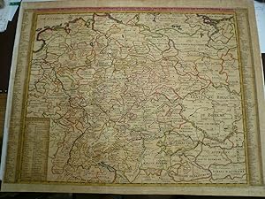
Europe/Germany-map, anno 1732, Chatelain, old colours Antique print, titled: 'Nouvelle Carte de l Empire divise selon ses differents Etats: avec des Tables pour trouver Facilement les Etats de Chaque Prince par les Lettres Alphabetiques. ' - New Map of the Empire divided according to its different states: with tables to find Easily the states of each Prince by alphabetic letters. This print/map originates from: "Atlas Historique." (Historic Atlas.), Published by Zacharie Chatelain, Amsterdam, 1732. Published in seven volumes between 1705 and 1720. This 2nd edition (Tome II) has been published in 1732. The maps were accompanied by information on cosmography, geography, history, genealogy, heraldry, and costumes of the world. The image s
Date d'ťdition : 1732
Vendeur : Hammelburger Antiquariat, Hammelburg, Allemagne
…valuation du vendeur 5 sur 5 ťtoiles
Carte
EUR 160
Autre deviseEUR 9 expťdition depuis Allemagne vers FranceQuantitť disponible : 1 disponible(s)
Ajouter au panierKein Einband. Etat : Ausreichend. Europe/Germany-map, anno 1732, Chatelain, old colours Antique print, titled: 'Nouvelle Carte de l Empire divise selon ses differents Etats: avec des Tables pour trouver Facilement les Etats de Chaque Prince par les Lettres Alphabetiques. ' - New Map of the Empire divided according to its different states: with tables to find Easily the states of each Prince by alphabetic letters. This print/map originates from: "Atlas Historique." (Historic Atlas.), Published by Zacharie Chatelain, Amsterdam, 1732. Published in seven volumes between 1705 and 1720. This 2nd edition (Tome II) has been published in 1732. The maps were accompanied by information on cosmography, geography, history, genealogy, heraldry, and costumes of the world. The image size is ca. 62 x 47 cm. Contemporary colours, little brownish, some small tears on margins.
-
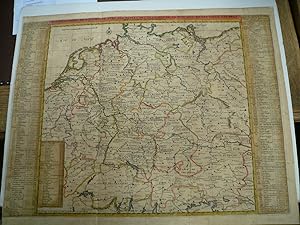
Germany/Europe, generalmap by Chatelain Henri, anno 1732, old colours Nouvelle Carte De L'Allemagne avec des Tables des. Nouvelle Carte De L'Allemagne avec des Tables des Branches de la Noblesse et les Lieux Les Plus Remarquables de Leurs Residance Paris / 1732 Size of the sheet: 51 x 64 cm., old colours, little brownish. Detailed map of the German Empire, from Chatelain's monumental 7 volume Atlas Historique, published by Chatelain in Amsterdam The map is flanked by two tables identifying the principal towns and regions associated with each of the different dynasties.
Date d'ťdition : 1732
Vendeur : Hammelburger Antiquariat, Hammelburg, Allemagne
…valuation du vendeur 5 sur 5 ťtoiles
Carte
EUR 180
Autre deviseEUR 9 expťdition depuis Allemagne vers FranceQuantitť disponible : 1 disponible(s)
Ajouter au panierKein Einband. Etat : Befriedigend. Germany/Europe, generalmap by Chatelain Henri, anno 1732, old colours Nouvelle Carte De L'Allemagne avec des Tables des. Nouvelle Carte De L'Allemagne avec des Tables des Branches de la Noblesse et les Lieux Les Plus Remarquables de Leurs Residance Paris / 1732 Size of the sheet: 51 x 64 cm., old colours, little brownish. Detailed map of the German Empire, from Chatelain's monumental 7 volume Atlas Historique, published by Chatelain in Amsterdam The map is flanked by two tables identifying the principal towns and regions associated with each of the different dynasties.
-
Vue et description de Surate et de Batavia, anno 1719, Chatelain Size of the sheet: 46 x 28 cm., very good condition, printed on thick paper, wide margins, clean print. Attractive view of the town and harbor of Surate on the northwest coast of India, and a bird's-eye city plan of Batavia (Jakarta) present-day capital of Indonesia, from Chatelain's monumental 7 volume Atlas Historique, published in Amsterdam. Surate was the first English trading post in India and was known as a gold and textile center. Batavia was the capital of the Dutch East Indian trading empire during the period when the Dutch dominated trade from the famous Spice Islands. Henri Abraham Chatelain (1684-1743) was a Huguenot pastor of Parisian origins. Chatelain proved a s
Date d'ťdition : 1719
Vendeur : Hammelburger Antiquariat, Hammelburg, Allemagne
…valuation du vendeur 5 sur 5 ťtoiles
Art / Affiche / Gravure
EUR 190
Autre deviseEUR 9 expťdition depuis Allemagne vers FranceQuantitť disponible : 1 disponible(s)
Ajouter au panierKein Einband. Etat : Sehr gut. Vue et description de Surate et de Batavia, anno 1719, Chatelain Size of the sheet: 46 x 28 cm., very good condition, printed on thick paper, wide margins, clean print. Attractive view of the town and harbor of Surate on the northwest coast of India, and a bird's-eye city plan of Batavia (Jakarta) present-day capital of Indonesia, from Chatelain's monumental 7 volume Atlas Historique, published in Amsterdam. Surate was the first English trading post in India and was known as a gold and textile center. Batavia was the capital of the Dutch East Indian trading empire during the period when the Dutch dominated trade from the famous Spice Islands. Henri Abraham Chatelain (1684-1743) was a Huguenot pastor of Parisian origins. Chatelain proved a successful businessman, creating lucrative networks in London, The Hague, and then Amsterdam. He is most well known for the Atlas Historique, published in seven volumes between 1705 and 1720.
-
Izmir-Smyrne, Habillemens Des Femmes De Smyrne, Des Grecques et des Iuifuves de cette Ville Decorative set of images of the area aound Smyrne, along with costumes showing the Greek and Jewish female inhabitants of Smyrne, from Chatelain's monumental 7 volume Atlas Historique., anno 1719ize of the leaf: 47 x 56 cm., good print
Date d'ťdition : 1719
Vendeur : Hammelburger Antiquariat, Hammelburg, Allemagne
…valuation du vendeur 5 sur 5 ťtoiles
Art / Affiche / Gravure
EUR 200
Autre deviseEUR 9 expťdition depuis Allemagne vers FranceQuantitť disponible : 1 disponible(s)
Ajouter au panierKein Einband. Etat : Gut. Izmir-Smyrne, Habillemens Des Femmes De Smyrne, Des Grecques et des Iuifuves de cette Ville Decorative set of images of the area aound Smyrne, along with costumes showing the Greek and Jewish female inhabitants of Smyrne, from Chatelain's monumental 7 volume Atlas Historique., anno 1719ize of the leaf: 47 x 56 cm., good print.
-
Persepolis, anno 1719, copperengraving, Chatelain Henri Des Tombeaux & Autres Monumens Anciens Que L'on Trouve Non Loin De Persepolis Dans Une Montagne de Roche appelle La Montagne des Sepulchres Decorative copperplate engraving showing the Tombs and other monuments to the Ancient Kings of Persia. Size of the sheet: 47 x 56 cm., clear print, wide margins, only small restoration on below centerfold, not to see in front. From Chatelain's monumental 7 volume Atlas Historique.
Date d'ťdition : 1719
Vendeur : Hammelburger Antiquariat, Hammelburg, Allemagne
…valuation du vendeur 5 sur 5 ťtoiles
Carte
EUR 200
Autre deviseEUR 9 expťdition depuis Allemagne vers FranceQuantitť disponible : 1 disponible(s)
Ajouter au panierKein Einband. Etat : Befriedigend. Persepolis, anno 1719, copperengraving, Chatelain Henri Des Tombeaux & Autres Monumens Anciens Que L'on Trouve Non Loin De Persepolis Dans Une Montagne de Roche appelle La Montagne des Sepulchres Decorative copperplate engraving showing the Tombs and other monuments to the Ancient Kings of Persia. Size of the sheet: 47 x 56 cm., clear print, wide margins, only small restoration on below centerfold, not to see in front. From Chatelain's monumental 7 volume Atlas Historique.


![Image du vendeur pour Atlas Historique, Ou Nouvelle Introduction A l'Histoire, ŗ la Chronologie & ŗ la Geographie Ancienne & Moderne. Reprťsentťe dans de Nouvelles Cartes, Oý l'on remarque l'Etablissement des Etats & Empires du Monde, leur durťe, leur chŻte, & leurs differens Gouvernemens; La Chronologie des Consuls Romains, des Papes, des Empereurs, des Rois, & des Princes, &c. qui ont ťtť depuis le commencement du Monde, jusqu'ŗ prťsent: Et la Gťnealogie des Maisons Souveraines de l'Europe Tome IV: Qui comprend le Dannemarck, la Suede, la Pologne, la Moscovie, la Turquie, [et]c. mis en vente par Antiquariat Peter Fritzen](https://pictures.abebooks.com/inventory/md/md32091273341.jpg)
![Image du vendeur pour Atlas Historique, Ou Nouvelle Introduction A l'Histoire, ŗ la Chronologie & ŗ la Geographie Ancienne & Moderne. Reprťsentťe dans de Nouvelles Cartes, Oý l'on remarque l'Etablissement des Etats & Empires du Monde, leur durťe, leur chŻte, & leurs differens Gouvernemens; La Chronologie des Consuls Romains, des Papes, des Empereurs, des Rois, & des Princes, &c. qui ont ťtť depuis le commencement du Monde, jusqu'ŗ prťsent: Et la Gťnealogie des Maisons Souveraines de l'Europe Tome II. Seconde Partie. Ou Tome III: Qui comprend la Grande Bretagne, l'Irlande, la Suisse, la Savoye, la Lorraine [et] la Republique de Venise. mis en vente par Antiquariat Peter Fritzen](https://pictures.abebooks.com/inventory/md/md32091268768.jpg)