
Montant total (1 article articles) :
Destination de la commande :

atlas minor de seutter matthäus (10 résultats)
Commentaires
Passer aux résultats principaux de la recherche
Filtres de recherche
Type d'article
- Tous les types de produits
- Livres (3)
- Magazines & Périodiques (Aucun autre résultat ne correspond ŕ ces critčres)
- Bandes dessinées (Aucun autre résultat ne correspond ŕ ces critčres)
- Partitions de musique (Aucun autre résultat ne correspond ŕ ces critčres)
- Art, Affiches et Gravures (Aucun autre résultat ne correspond ŕ ces critčres)
- Photographies (Aucun autre résultat ne correspond ŕ ces critčres)
- Cartes (7)
- Manuscrits & Papiers anciens (Aucun autre résultat ne correspond ŕ ces critčres)
Etat En savoir plus
- Neuf (Aucun autre résultat ne correspond ŕ ces critčres)
- Comme neuf, Trčs bon ou Bon (Aucun autre résultat ne correspond ŕ ces critčres)
- Assez bon ou satisfaisant (7)
- Moyen ou mauvais (Aucun autre résultat ne correspond ŕ ces critčres)
- Conformément ŕ la description (3)
Reliure
- Toutes
- Couverture rigide (Aucun autre résultat ne correspond ŕ ces critčres)
- Couverture souple (2)
Particularités
- Ed. originale (Aucun autre résultat ne correspond ŕ ces critčres)
- Signé (Aucun autre résultat ne correspond ŕ ces critčres)
- Jaquette (Aucun autre résultat ne correspond ŕ ces critčres)
- Avec images (10)
- Sans impressions ŕ la demande (10)
Langue (3)
Prix
- Tous les prix
- Moins de EUR 20 (Aucun autre résultat ne correspond ŕ ces critčres)
- EUR 20 ŕ EUR 45 (Aucun autre résultat ne correspond ŕ ces critčres)
- Plus de EUR 45
Livraison gratuite
Pays
Evaluation du vendeur
-
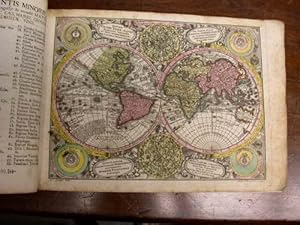
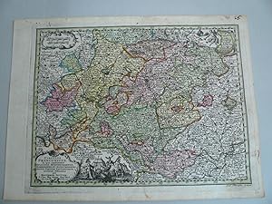
[Map] "Diversi Globi Terr-Aquei Statione Variante et Visu Intercedente, Per Coluros Tropicorum Per Ambos Polos et Particul, Sphaerae Zenith in Planum Deleati Orthographici Prospectus" from Atlas Minor?
Edité par Georg Matthaus Seutter, Augsburg, 1744
Langue: anglais
Vendeur : Lloyd Zimmer, Books and Maps, Chanute, KS, Etats-Unis
Évaluation du vendeur 5 sur 5 étoiles

Carte
EUR 703,97
Autre deviseEUR 4,27 expédition vers Etats-UnisQuantité disponible : 1 disponible(s)
Ajouter au panierSoft cover. Etat : Very Good. No Jacket. Highly decorative map of the hemispheres. Steel engraving with hand coloring. 10 Ľ x 8 inches, on slightly larger leaf. California is shown as an Island. Strong impression on hand laid paper with water-mark. Top edge trimmed close to border. Smudges and some darkening near edges and lightly scattered through image. Good, contemporary coloring.
-
Atlas Minor.
Edité par Augsburg: [c1744]., 1744
Vendeur : D & E LAKE LTD. (ABAC/ILAB), Toronto, ON, Canada
Membre d'association : ABAC ILAB
Évaluation du vendeur 3 sur 5 étoiles

EUR 16 895,24
Autre deviseEUR 12,81 expédition depuis Canada vers Etats-UnisQuantité disponible : 1 disponible(s)
Ajouter au panierSoft cover. Etat : Very Good. oblong folio. [pp. 34]. hand-coloured engraved title with an elaborate allegorical border of the Continents, Empire and the Gods by Martin Gottfrid Crophius after Jacob Christoph Weyerman & 65 hand-coloured engraved maps by Tobias Conrad Lotter, Albrecht Carl Seutter, & Andreas Silbereisen after Matthäus Seutter & Albrecht Carl Seutter. woodcut tailpiece. contemporary limp calf (rubbed & cockled, edges chipped, staining to portion of last 4 maps, scattered foxing & some marginal dampstaining & minor tears, several tiny wormholes in first few leaves). An attractive atlas by one of the leading eighteenth century German map publishers and engravers. Including maps of the world, North America, South America, Asia, Africa, Russia, the Turkish Empire, Southern Russia and the Crimea, the Holy Land, and various countries and regions of Europe. The map of Genoa, by Matthäus Petter Läinpacher, does not appear in the index. cfNordenskiöld 283 (67 maps; 4 not listed in index). cfPhillips, Atlases, 3494 (68 maps: 4 not listed in index).
-
Atlas Minor . (Frontespizio)
Edité par Frontespizio
Vendeur : Sergio Trippini, Gavirate, VA, Italie
Membre d'association : ALAI ILAB
Évaluation du vendeur 4 sur 5 étoiles

EUR 120
Autre deviseEUR 46 expédition depuis Italie vers Etats-UnisQuantité disponible : 1 disponible(s)
Ajouter au panierIncisione, antica ed originale, raffigurante il frontespizio dell'opera "Atlas Minor praecipua Orbis Terrarum Imperia Regna et Provincias Germaniae Potissimum" pubblicata ad Augusta. La stampa, in coloritura coeva, č appilcata su margini anticamente riportati.
-
Kolorierte Kupferstichkarte - Imperium Romano-GErmanicum insuos circulos elect et Status suma cura et Studio divisum aeri insulpt. aus Atlas minor praecipua orbis terrarum imperia.
Edité par ohne Verlagsangabe, 1744
Langue: allemand
Vendeur : Antiquariat Buchseite, Purkersdorf, Autriche
Évaluation du vendeur 5 sur 5 étoiles
Carte
EUR 90
Autre deviseEUR 72,50 expédition depuis Autriche vers Etats-UnisQuantité disponible : 1 disponible(s)
Ajouter au panierca 25,5 x 20 cm. Etat : Gut. Erstauflage, EA. 1 Blatt schöne kolorierte Kupferstichkarte mit Titelkartusche hinter Pasepartout, mit Passepartout 40 x 30 cm, ohne Passepartout ca 25,5 x 20 cm, unten im linken Eck zarter Fleck, sonst guter Zustand Sprache: Deutsch Gewicht in Gramm: 1100.
-
Kolorierte Kupferstichkarte - Alsatia Landgraviatus cum utroque Marchionatu Badensi Sundgovia Brisgovia. aus Atlas minor praecipua orbis terrarum imperia.
Edité par ohne Verlagsangabe, 1744
Langue: allemand
Vendeur : Antiquariat Buchseite, Purkersdorf, Autriche
Évaluation du vendeur 5 sur 5 étoiles
Carte
EUR 108
Autre deviseEUR 72,50 expédition depuis Autriche vers Etats-UnisQuantité disponible : 1 disponible(s)
Ajouter au panierca 26,5 x 20 cm. Etat : Gut. Erstauflage, EA. 1 Blatt schöne kolorierte Kupferstichkarte mit Titelkartusche hinter Pasepartout, mit Passepartout 40 x 30 cm, ohne Passepartout ca 26,5 x 20 cm, guter Zustand Sprache: Deutsch Gewicht in Gramm: 1100.
-
Kolorierte Kupferstichkarte - Platinatus Inferior sive Electoratus Palatinus ad Rhenum cum adjacentibus Archi Episcopatu Moguntino Episcop Spirensi et Wormatiensi.axon. aus Atlas minor praecipua orbis terrarum imperia.
Edité par ohne Verlagsangabe, 1744
Langue: allemand
Vendeur : Antiquariat Buchseite, Purkersdorf, Autriche
Évaluation du vendeur 5 sur 5 étoiles
Carte
EUR 108
Autre deviseEUR 72,50 expédition depuis Autriche vers Etats-UnisQuantité disponible : 1 disponible(s)
Ajouter au panierca 25,5 x 20 cm. Etat : Gut. Erstauflage, EA. 1 Blatt schöne kolorierte Kupferstichkarte mit Titelkartusche hinter Pasepartout, mit Passepartout 40 x 30 cm, ohne Passepartout ca 25,5 x 20 cm, guter Zustand Sprache: Deutsch Gewicht in Gramm: 1100.
-
Kolorierte Kupferstichkarte - Circulus Bavaria in fuas quasq didion tam cum finitimis quam infertis Regionibus accuratissime divileri incis et venal exposit. aus Atlas minor praecipua orbis terrarum imperia.
Edité par ohne Verlagsangabe, 1744
Langue: allemand
Vendeur : Antiquariat Buchseite, Purkersdorf, Autriche
Évaluation du vendeur 5 sur 5 étoiles
Carte
EUR 108
Autre deviseEUR 72,50 expédition depuis Autriche vers Etats-UnisQuantité disponible : 1 disponible(s)
Ajouter au panierca 25,5 x 20 cm. Etat : Gut. Erstauflage, EA. 1 Blatt schöne kolorierte Kupferstichkarte mit Titelkartusche hinter Pasepartout, mit Passepartout 40 x 30 cm, ohne Passepartout ca 25,5 x 20 cm, guter Zustand Sprache: Deutsch Gewicht in Gramm: 1100.
-

Ierusalem, cum suburbiis, prout tempore Christi floruit . Abriss der Weltberuehmten Statt Ierusalem . nach dem Christ. Andrichomii abgezeichnet u. in Kupf(er) gestochen. Altkolorierter Kupferstich aus: Atlas minor. Praecipua orbis terrarum imperia.
Edité par Augsburg, Tobias Conrad Lotter, (ca. 1756)., 1756
Langue: allemand
Vendeur : Matthaeus Truppe Antiquariat, Graz, Autriche
Membre d'association : ILAB VDAO
Évaluation du vendeur 5 sur 5 étoiles
Carte
EUR 1 070
Autre deviseEUR 62 expédition depuis Autriche vers Etats-UnisQuantité disponible : 1 disponible(s)
Ajouter au panierCa. 57 cm x 49 cm. Gerahmt. Die bei Tobias Lotter gedruckte zweite Auflage dieses Plans der Stadt Jerusalem im Altertum von Matthäus Seutter (erstmals in dessen "Atlas Novus" von 1741 gedruckt). - Der Plan basiert im Wesentlichen auf jenem von Christian van Adrichom des Jahres 1584. Im unteren Drittel eine "Beschreibung der Statt Jerusalem, samt einer Erklärung was eine jede Ziffer Zahl in diesem Abriß derselben bedeute". - Leicht fleckig. *** *** Copyright: Matthaeus TRUPPE Buchhandlung & Antiquariat - Stubenberggasse 7 - A-8010 Graz - ++43 (0)316 - 829552 *** *** Sprache: Deutsch Gewicht in Gramm: 0.
-
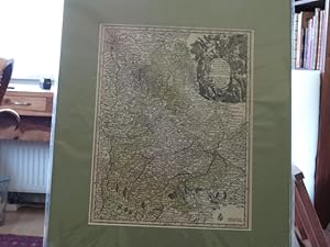
Franken-Circulus Franconicus, Seutter Matthaeus, Atlas Minor -anno 1740--- Franken-Circulus Franconicus, Seutter Matthaeus, Atlas Minor Altkoloriert, zeigt Franken, Blatt: 22 x 30 cm.
Date d'édition : 1740
Vendeur : Hammelburger Antiquariat, Hammelburg, Allemagne
Évaluation du vendeur 5 sur 5 étoiles
Carte
EUR 80
Autre deviseEUR 30 expédition depuis Allemagne vers Etats-UnisQuantité disponible : 1 disponible(s)
Ajouter au panierKein Einband. Etat : Gut. Franken-Circulus Franconicus, Seutter Matthaeus, Atlas Minor -anno 1740--- Franken-Circulus Franconicus, Seutter Matthaeus, Atlas Minor Altkoloriert, zeigt Franken, Blatt: 22 x 30 cm.
-
(Atlas Minor) - Atlantis Minoris.
Vendeur : Herman H. J. Lynge & Sřn ILAB-ABF, Copenhagen, Danemark
Membre d'association : ABF ILAB
Évaluation du vendeur 4 sur 5 étoiles
EUR 4 484,49
Autre deviseGratuit expédition depuis Danemark vers Etats-UnisQuantité disponible : 1 disponible(s)
Ajouter au panierAugsburg, Augustć Vind, (1744). 4to-oblong. Cont. hcalf. Back and covers somewhat worn. Platesizes ca. 20,5 x 27 cm. (32) pp. and 60 full-page engraved maps (of 64 listed). Lacking the engraved title and 5 other maps (Africa, America septentrionalis, Regum Portugallić, Regnum Hispanić, Italia totur and Palćstina), but having 2 more not listed and some in the German section does not corresponds with the maps listed in the index. All maps in original handcolouring, occasionally a little brownspotted and traces of use in lower right corners. One map have a little loss of image in lower middle (Austria Saliburgensis). Phillips No 3494. 2 maps relating to America (Globus Terrestris (World Map) and America Meridionalis). Having maps of Europe, Asia, Russia, Turkey, Scandinavia etc. The World Map engraved by Andr. Silbereisen and most of the other maps engraved by A.C. Seutter and Tobias C. Lotter (married to Seutters daughter and his successor).
![Image du vendeur pour [Map] "Diversi Globi Terr-Aquei Statione Variante et Visu Intercedente, Per Coluros Tropicorum Per Ambos Polos et Particul, Sphaerae Zenith in Planum Deleati Orthographici Prospectus" from Atlas Minor? mis en vente par Lloyd Zimmer, Books and Maps](https://pictures.abebooks.com/inventory/md/md17898870225.jpg)

