Montant total (1 article articles) :
Destination de la commande :

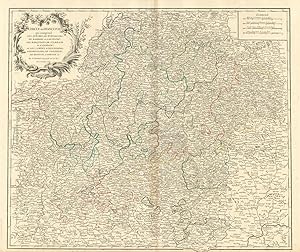
cercle de franconie, Ancien ou d'occasion (51 résultats)
Commentaires
Passer aux résultats principaux de la recherche
Filtres de recherche
Type d'article
- Tous les types de produits
- Livres (11)
- Magazines & Périodiques (Aucun autre résultat ne correspond ŕ ces critčres)
- Bandes dessinées (Aucun autre résultat ne correspond ŕ ces critčres)
- Partitions de musique (Aucun autre résultat ne correspond ŕ ces critčres)
- Art, Affiches et Gravures (17)
- Photographies (Aucun autre résultat ne correspond ŕ ces critčres)
- Cartes (23)
- Manuscrits & Papiers anciens (Aucun autre résultat ne correspond ŕ ces critčres)
Etat En savoir plus
- Neuf (Aucun autre résultat ne correspond ŕ ces critčres)
- Comme neuf, Trčs bon ou Bon (4)
- Assez bon ou satisfaisant (8)
- Moyen ou mauvais
- Conformément ŕ la description (39)
Reliure
- Toutes
- Couverture rigide (Aucun autre résultat ne correspond ŕ ces critčres)
- Couverture souple (Aucun autre résultat ne correspond ŕ ces critčres)
Particularités
Langue (3)
Livraison gratuite
- Livraison gratuite ŕ destination de France (Aucun autre résultat ne correspond ŕ ces critčres)
Pays
Evaluation du vendeur
-
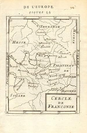
Cercle de Franconie - De L'Europe
Vendeur : Antiqua Print Gallery, London, Royaume-Uni
Évaluation du vendeur 3 sur 5 étoiles

EUR 10,03
Autre deviseEUR 12,60 expédition depuis Royaume-Uni vers FranceQuantité disponible : 4 disponible(s)
Ajouter au panier -

"Cercle de Franconie qui comprend les Eveches de Wurtzbourg, de Bamberg et d'Aichstet; les Marquisats de Culmbach et d'Anspach; et les Comtes d'Henneberg, d'Hohenlohe, de Vertheim, de Reineck, d'Erpach &c." - Franken Bayern Bamberg Nürnberg Erlangen Coburg Ansbach Bayreuth Eichstätt Wertheim Karte map
Edité par Paris, 1752
Langue: français
Vendeur : Antiquariat Steffen Völkel GmbH, Seubersdorf, Allemagne
Membre d'association : ILAB VDA
Évaluation du vendeur 5 sur 5 étoiles

Carte
EUR 49,99
Autre deviseEUR 19,70 expédition depuis Allemagne vers FranceQuantité disponible : 1 disponible(s)
Ajouter au panierAltkolorierte Kupferstich-Karte. - Bild-Maße: ca. 48 x 55 cm. -- am oberen Rand etwas wasserfleckig (außerhalb der Karte), sonst gut erhalten. || Old colored engraved map. - with some waterstaining on the upper margin (outside of the map itself), otherwise in good condition. Wir kaufen und verkaufen alte Bücher, Handschriften, Zeichnungen, Autographen, Grafiken und Fotografien. Wir sind stets am Ankauf von kompletten Bibliotheken, Sammlungen und Nachlässen interessiert. Sprache: Französisch Gewicht in Gramm: 35.
-
"Cercle de Franconie qui comprend les Eveches de Wurtzbourg, de Bamberg et d'Aichstet; les Marquisats de Culmbach et d'Anspach; et les Comtes d'Henneberg, d'Hohenlohe, de Vertheim, de Reineck, d'Erpach &c." - Franken Bayern Bamberg Nürnberg Erlangen Coburg Ansbach Bayreuth Eichstätt Wertheim Karte map
Edité par Paris, 1752
Langue: français
Vendeur : Antiquariat Steffen Völkel GmbH, Seubersdorf, Allemagne
Membre d'association : ILAB VDA
Évaluation du vendeur 5 sur 5 étoiles
Carte
EUR 59,99
Autre deviseEUR 19,70 expédition depuis Allemagne vers FranceQuantité disponible : 1 disponible(s)
Ajouter au panierGroßformatige handkolorierte originalKupferstich-Kartevon 1752. - Blattmasse: ca. 51 x 67 cm. -- gut erhalten. || Large handcolored original engraved map from 1752. -- in good condition. || Dies ist ein Original! - Kein Nachdruck! - Keine Kopie! -- This is an original! No copy! - No reprint! Wir kaufen und verkaufen alte Bücher, Handschriften, Zeichnungen, Autographen, Grafiken und Fotografien. Wir sind stets am Ankauf von kompletten Bibliotheken, Sammlungen und Nachlässen interessiert. Sprache: Französisch Gewicht in Gramm: 1550.
-

"Cercle de Franconie qui comprend les eveches de Wurtzbourg, de Bamberg et d'Aichstet, les Marquisats de Culmbach et d'Anspach; et les Comtes d'Henneberg, d'Hohenlohe, de Vertheim, de Reineck, d'Erpach &c" - Franken Nürnberg Würzburg Erlangen Coburg Bayreuth Bamberg Aschaffenburg
Edité par Venezia, Santini & Remondini, 1778
Langue: français
Vendeur : Antiquariat Steffen Völkel GmbH, Seubersdorf, Allemagne
Membre d'association : ILAB VDA
Évaluation du vendeur 5 sur 5 étoiles
Carte
EUR 69,99
Autre deviseEUR 19,70 expédition depuis Allemagne vers FranceQuantité disponible : 1 disponible(s)
Ajouter au panierGroßformatige altkolorierte Kupferstich-Karte von 1778 -- Blatt-Maße: ca. 52,5 x 75,5 cm. -- gut erhalten. || Large old colored engraved map from 1778. -- in good condition. || Francesco Santini was a Venetian publisher. He acquired the printing plates of Vaugondy's Atlas Universel, a commercial and cartographic success, with widespread influence on mapmakers throughout Europe. Together with his brother Paolo, he commissioned a new set of plates and reissued the atlas in 1776. In the following years, Paolo Santini assigned all his publication rights to M. Remondini, who in 1777 reissued the same atlas, but with his name. Wir kaufen und verkaufen alte Bücher, Handschriften, Zeichnungen, Autographen, Grafiken und Fotografien. Wir sind stets am Ankauf von kompletten Bibliotheken, Sammlungen und Nachlässen interessiert. Sprache: Französisch Gewicht in Gramm: 550.
-

Der Fränckische Kreyss - Cercle de Franconie
Edité par Jean David Zunner, Frankfurt, 1686
Vendeur : Antiquariat Reinhold Berg eK Inh. R.Berg, Regensburg, Allemagne
Membre d'association : ILAB VDA
Évaluation du vendeur 5 sur 5 étoiles
Carte
EUR 45
Autre deviseEUR 18 expédition depuis Allemagne vers FranceQuantité disponible : 1 disponible(s)
Ajouter au panierGrafik. Copper engraving published in Allain M. Mallet's description of the world 'Description De L' Univers, Contenant Les Differents Systemes Du Monde, Les Cartes generales & particulieres.'. French text edition with additional German titles on top. A strong impression, uncolored as published. In excellent condition. 150 by 112mm (6 by 4˝ inches).
-

[Carte géographique]. Le Cercle de Souabe et partie de Celuy de Franconie.
Edité par Paris, Chez l'auteur, fin XVII°s.
Vendeur : Librairie Devaux, Moulins, FR, France
Évaluation du vendeur 3 sur 5 étoiles
EUR 60
Autre deviseEUR 10,50 expédition vers FranceQuantité disponible : 1 disponible(s)
Ajouter au panier60,7 x 47,3 cm ŕ la cuvette + marges. Pas de cartouche, légende dans le bord supérieur. C. Inselin scripsit. Olten au sud-ouest, Mittewald au sud-est, Neumarck au nord-est et Kaseloutre au nord-ouest. Le lac de Constance en bas. Frontičres rehaussées (coloris anciens). - Épreuve fraîche, non rognée. Marge de gauche légčrement froissée.
-
Cercle/de/Franconie
Edité par Germania - Franconia
Vendeur : Sergio Trippini, Gavirate, VA, Italie
Membre d'association : ALAI ILAB
Évaluation du vendeur 4 sur 5 étoiles

EUR 50
Autre deviseEUR 23 expédition depuis Italie vers FranceQuantité disponible : 1 disponible(s)
Ajouter au panierCarta della regione tedesca.
-

"Cercle De Franconie" - Franken / Bayern Bavaria / Karte map carte
Edité par Paris, Jean Baptiste Mitoire c. 1750., 1750
Langue: français
Vendeur : Antiquariat Steffen Völkel GmbH, Seubersdorf, Allemagne
Membre d'association : ILAB VDA
Évaluation du vendeur 5 sur 5 étoiles
Art / Affiche / Gravure
EUR 149,99
Autre deviseEUR 19,70 expédition depuis Allemagne vers FranceQuantité disponible : 1 disponible(s)
Ajouter au panierSehr seltene original Kupferstich Spielkarte aus dem 18. Jh. -- Maße: ca. 8,5 x 6 cm. -- Rückseite unbedruckt - sehr gut erhalten. || Very rare original engraved playing card from the 18th century. - verso: blank - in very good condition. Wir kaufen und verkaufen alte Bücher, Handschriften, Zeichnungen, Autographen, Grafiken und Fotografien. Wir sind stets am Ankauf von kompletten Bibliotheken, Sammlungen und Nachlässen interessiert. Sprache: Französisch Gewicht in Gramm: 10.
-

orig. Kupferstich-Landkarte von Philippe (de Pretot). Bayern Franken Coburg Chorographie du Cercle de Franconie daprčs Valck et Hubner.
Edité par Paris um 1775., 1775
Langue: allemand
Vendeur : Allgäuer Online Antiquariat, Memmingen, DE, Allemagne
Membre d'association : GIAQ
Évaluation du vendeur 5 sur 5 étoiles
Art / Affiche / Gravure
EUR 75
Autre deviseEUR 10,50 expédition depuis Allemagne vers FranceQuantité disponible : 1 disponible(s)
Ajouter au panierAnsichtsgröße 27 x 40,5cm, Etat : Gut. Blattgröße 33,5 x 48cm, Doppelblatt mit Mittelfalte, zeigend Franken mit den Städten Nürnberg, Würzburg, Coburg, links oben mit Kartusche, unten Meilenzeiger und Legende der Symbole. Für die Echtheit und Qualität der von uns angebotenen Stiche garantieren wir - Auf Wunsch, gegen Aufpreis mit Rahmen. Fragen Sie gerne bei uns an. Sprache: Deutsch Gewicht in Gramm: 1000.
-

Cercle de Franconie. (Bayern).
Vendeur : Antiquariat Martin Barbian & Grund GbR, Saarbruecken, Allemagne
Évaluation du vendeur 5 sur 5 étoiles
Art / Affiche / Gravure
EUR 45
Autre deviseEUR 16 expédition depuis Allemagne vers FranceQuantité disponible : 1 disponible(s)
Ajouter au paniergrenzkolorierter Kupferstich von Robert de Vaugondy, 1749, 16x15 cm (Alte Landkarten / Deutschland / Antique Maps / Germany).
-

Kupferstich-Landkarte von Philippe (de Pretot). Chorographie du Cercle de Franconie d'aprčs Valck et Hubner.
Edité par Paris, , um 1775., 1775
Vendeur : Antiquariat Thomas Rezek, München, Allemagne
Évaluation du vendeur 5 sur 5 étoiles
Art / Affiche / Gravure
EUR 80
Autre deviseEUR 16 expédition depuis Allemagne vers FranceQuantité disponible : 1 disponible(s)
Ajouter au paniercirca 29,5 x 23,8 cm. 1 Doppelblatt mit Mittelfalte Franken mit Nürnberg, Würzburg, Coburg, oben links Kartusche, unten Meilenzeiger und Legende der Symbole, seltenere französische Karte. - Wenig angestaubt, gut erhalten.
-

Cercle de Franconie. divisé en ses princip ux Etats Par le Sr. Robert de Vaugondy
Edité par Paris, 1749
Vendeur : Antiquariat Reinhold Berg eK Inh. R.Berg, Regensburg, Allemagne
Membre d'association : ILAB VDA
Évaluation du vendeur 5 sur 5 étoiles
Carte
EUR 80
Autre deviseEUR 18 expédition depuis Allemagne vers FranceQuantité disponible : 1 disponible(s)
Ajouter au panierGrafik. Original antiker Kupferstich in zeitgenössischem Grenzkolorit. Eine seltene und schöne Karte von Franken in Deutschland. Franken war eine Verwaltungseinheit im Heiligen Römischen Reich, bevor 1871 der moderne Staat Deutschland gegründet wurde. Diese Karte wurde ursprünglich in Robert de Vaugondys Atlas Portatif Unviversel et Militaire herausgegeben. In ausgezeichnetem Zustand. 162 by 154mm (6˝ by 6 inches).
-

Cercle de Franconie, divisé en ses princip.ux Etats. Par le Sr. Robert de Vaugondy fils de Mr. Robert Geog. ord. du Roi.
Edité par Paris, Durand & Pissot, 1749,, 1749
Vendeur : Harteveld Rare Books Ltd., Marly, Suisse
Membre d'association : ILAB VEBUKU
Évaluation du vendeur 4 sur 5 étoiles
EUR 101,50
Autre deviseEUR 15 expédition depuis Suisse vers FranceQuantité disponible : 1 disponible(s)
Ajouter au panier17.5 x 16 cm (25 x 37 cm, la feuille), carte coloriée, papier légčrement bruni. 1 feuille. Carte tirée de: Gilles Robert de Vaugondy, Atlas portatif universel et militaire, Paris, Durand & Pissot, 1748-1749.Please notify before visiting to see a book. Prices are excl. VAT/TVA (only Switzerland) & postage.
-

'CERCLE DE FRANCONIE, SUIVANT LES NOUVELLES OBSERVATIONS'. Map of Franconia in southern Germany with pictorial cartouche, Schweinfurt and Bamberg in the centre
Edité par Pieter van der Aa, Leiden 1714, 1714
Vendeur : Garwood & Voigt, Sevenoaks, Royaume-Uni
Évaluation du vendeur 5 sur 5 étoiles
Carte
EUR 88,49
Autre deviseEUR 27,49 expédition depuis Royaume-Uni vers FranceQuantité disponible : 1 disponible(s)
Ajouter au panier23x30cm. Uncoloured. Excellent condition. Folio edition - no centrefolds.
-
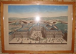
79č vue d'optique représentant Vue du nouveau Palais de Mgr l'évęque et Prince de Wutzbourg dans le cercle de Franconie.
Edité par XVIIIč sičcle
Vendeur : Librairie Seigneur, VOINGT, France
Évaluation du vendeur 5 sur 5 étoiles
Art / Affiche / Gravure Edition originale Signé
EUR 135
Autre deviseEUR 9,40 expédition vers FranceQuantité disponible : 1 disponible(s)
Ajouter au panierédition originale. Cadre. Beaux coloris. A Paris, chez J. Chéreau rue Saint Jacques au dessus de la fontaine Saint Severin aux 2 colonnes n° 257 Le graveur a signé , ce qui est rare pour une vue d'optique. ŕ vue 24 x 41. Avec cadre : 36 x 52,5.
-

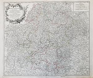
"L'Electorat de Mayence le Bas Palatinat et une Partie des Pays de Hesse et de la Riviere du Mein respresentant ensemble les Paties du Cercle Occidental de Franconie, savoir la plus basse partie de l'Eveche de Wurtzbourg, le Comte de Wertheim, Reineck, Hohenlo, Erpach &c." - Frankfurt a. Main Mainz Darmstadt Koblenz Wertheim Worms St. Goar Mannheim Heidelberg Heilbronn Hessen / Rheinland-Pfalz
Edité par Amsterdam, Convens & Mortier ca. 1750., 1750
Langue: français
Vendeur : Antiquariat Steffen Völkel GmbH, Seubersdorf, Allemagne
Membre d'association : ILAB VDA
Évaluation du vendeur 5 sur 5 étoiles
Carte
EUR 149,99
Autre deviseEUR 19,70 expédition depuis Allemagne vers FranceQuantité disponible : 1 disponible(s)
Ajouter au panierBlatt-Maße: ca. 66 x 53 cm. -- Altkolorierte Kupferstich-Karte. -- gut erhalten. || Old colored engraved map. -- in good condition. Wir kaufen und verkaufen alte Bücher, Handschriften, Zeichnungen, Autographen, Grafiken und Fotografien. Wir sind stets am Ankauf von kompletten Bibliotheken, Sammlungen und Nachlässen interessiert. Sprache: Französisch Gewicht in Gramm: 35.
-

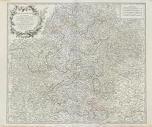
"Partie Orientale du Cercle de Franconie dresses sur les Memoires les plus Nouveaux" - Franken Nürnberg Bamberg Würzburg Schweinfurt Oberpfalz Bayreuth Neumarkt Ansbach Kulmbach Coburg Hof Regensburg Dinkelsbühl Weissenburg Rothenburg Eichstätt Seubersdorf Parsberg / Bayern
Edité par Amsterdam, Convens & Mortier ca. 1750., 1750
Langue: français
Vendeur : Antiquariat Steffen Völkel GmbH, Seubersdorf, Allemagne
Membre d'association : ILAB VDA
Évaluation du vendeur 5 sur 5 étoiles
Carte
EUR 149,99
Autre deviseEUR 19,70 expédition depuis Allemagne vers FranceQuantité disponible : 1 disponible(s)
Ajouter au panierBlatt-Maße: ca. 66 x 53 cm. -- Altkolorierte Kupferstich-Karte. -- gut erhalten. || Old colored engraved map. -- in good condition. Wir kaufen und verkaufen alte Bücher, Handschriften, Zeichnungen, Autographen, Grafiken und Fotografien. Wir sind stets am Ankauf von kompletten Bibliotheken, Sammlungen und Nachlässen interessiert. Sprache: Französisch Gewicht in Gramm: 35.
-
Cercle de Franconie qui comprend: Les Evęchés de Wüuzbourg de Bamberg et d'Aichstet; les marquisats de Culmbach et Anspach; et les Comtés d'Henneberg d' Hohenlohe de Vertheim de Reineck D'Erpach &
Edité par Paris,, 1752
Carte
EUR 165
Autre deviseEUR 6 expédition vers FranceQuantité disponible : 1 disponible(s)
Ajouter au panierPas de couverture. Etat : Bon. Carte gravée originale provenant de l'Atlas de Robert de Vaugondy; bon état général de la carte qui comporte une ou deux petites tâches; des tâches plus importantes ont pu ętre éliminées de cette feuille; certaines frontičres sont anciennement marquées en couleur; dimensions de la feuille: 68X50 cm; dimensions de la gravure: 55,5X47,5 cm; bon exemplaire de la premičre édition;
-

Cercle de Franconie, suivant les Nouvelles Observations de Messrs de L'Academie Royale des Sciences etc.
Edité par Leiden. c1713-14, 1713
Vendeur : Peter Harrington. ABA/ ILAB., London, Royaume-Uni
Membre d'association : ABA ILAB PBFA
Évaluation du vendeur 5 sur 5 étoiles
EUR 176,97
Autre deviseEUR 11,45 expédition depuis Royaume-Uni vers FranceQuantité disponible : 1 disponible(s)
Ajouter au panierPieter van der AA (1659-1733) was from a family of booksellers and publishers in Leiden, who flourished during the late seventeenth and early eighteenth centuries. His work was well executed and highly regarded by his contemporaries. The maps themselves are easily recognized and distinguished by their attractive title cartouches, and for the precise cartographic detail they contain. Size: 245 x 335 mm. Copperplate engraving with original outline colour and later hand colour. Good condition, although some discolouration to the central fold and a small hole to lower margin.
-
Carte géographique d'Homann CERCLE DE FRANCONIE EN ALLEMAGNE, NURENBERG NURNBERG
Edité par -
Vendeur : Librairie Maxime Katz, Villeurbanne, FR, France
Évaluation du vendeur 2 sur 5 étoiles

Edition originale
EUR 75
Autre deviseEUR 5,75 expédition vers FranceQuantité disponible : 1 disponible(s)
Ajouter au panierEtat : Fine. Etat de la jaquette : Fine. CARTE GÉOGRAPHIQUEPar HomannA Nuremberg18eme sičcle-Carte toilée de 56 x 49 cmAssez belle état (voir les photos)CARTE GÉOGRAPHIQUE ORIGINALE DU XVIIIeme sičcle. -. Carte gĂ©ographique.
-
CERCLE DU BAS RHIN WESPHALLE HESSE FRANCONIE Abbé Clouet Mondard 1769
Langue: français
Vendeur : Librairie AMB, SAINT-OUEN-SUR-SEINE, STOUE, France
Évaluation du vendeur 1 sur 5 étoiles

EUR 185
Autre deviseEUR 8,86 expédition vers FranceQuantité disponible : 1 disponible(s)
Ajouter au panierFeuille. Etat : Bon Etat. Physique CERCLE DU BAS RHIN WESPHALLE HESSE FRANCONIE Abbé Clouet Mondard 1769 0g.
-
Cercle de Franconie qui comprend les Evęchés de Wurtzbourg, de Bamberg et d'Aichstet; les Marquisats de Culmbach et d'Anspach; et les Comtés d'Henneberg, d'Hohenlohe, de Vertheim, de Reineck, d'Erpach &c. Par le Sr. Robert Géographe ord. du Roy. Avec Privilege
Date d'édition : 1752
Vendeur : Antiqua Print Gallery, London, Royaume-Uni
Évaluation du vendeur 3 sur 5 étoiles
Carte
EUR 70,79
Autre deviseEUR 12,60 expédition depuis Royaume-Uni vers FranceQuantité disponible : 1 disponible(s)
Ajouter au panierEtat : Good. "Cercle de Franconie". Franconia, Germany. Northern Bavaria. VAUGONDY 1752 map. Large antique 18th century atlas map, printed on thick, good quality paper with original outline hand colour/color and decorative title cartouche; Robert de Vaugondy, Gilles & Didier (1752). 49.5 x 59.0cm, 19.5 x 23.25 inches; this is a folding map. Condition: Good. There is nothing printed on the reverse side, which is plain.
-
Cercle de Franconie qui comprend les Evęchés de Wurtzbourg, de Bamberg et d'Aichstet; les Marquisats de Culmbach et d'Anspach; et les Comtés d'Henneberg, d'Hohenlohe, de Vertheim, de Reineck, d'Erpach &c. Par le Sr. Robert Géographe ord. du Roy. Avec Privilege
Date d'édition : 1752
Vendeur : Antiqua Print Gallery, London, Royaume-Uni
Évaluation du vendeur 3 sur 5 étoiles
Carte
EUR 70,79
Autre deviseEUR 12,60 expédition depuis Royaume-Uni vers FranceQuantité disponible : 1 disponible(s)
Ajouter au panierEtat : Good. "Cercle de Franconie". Franconia. Northern Bavaria. Germany. VAUGONDY 1752 map. Large antique 18th century atlas map, printed on thick, good quality paper with original outline hand colour/color and decorative title cartouche; Robert de Vaugondy, Gilles & Didier (1752). 50.0 x 60.0cm, 19.75 x 23.5 inches; this is a folding map. Condition: Good. There is nothing printed on the reverse side, which is plain.
-

EUR 240
Autre deviseEUR 20 expédition depuis Espagne vers FranceQuantité disponible : 1 disponible(s)
Ajouter au panierEtat : ACEPTABLE. Atlas portatif universel et militaire Par le Sr Robert de Vaugondy Fils de Mr. Robert Geog. Ord. Du Roi. Avec Privilege Gilles y Didier Robert de Vaugondy, padre e hijo, fueron famosos cartógrafos franceses del siglo XVIII. Eran descendientes del también cartógrafo Nicolas Sanson de quien heredaron gran parte de su material cartográfico. En 1760, Didier Robert de Vaugondy fue nombrado geógrafo de Luis XV En 1757 publicaron su más famosa obra, el Atlas Universel Formato (cm): 17x17.
-
FRANKEN: LE CERCLE DE FRANCONIE SUBDIVISÉ EN TOUS LE ESTATS QUI LE COMPOSENT
Edité par Alexis Hubert JAILLOT, Paris, 1674
Carte
EUR 395
Autre deviseEUR 6 expédition vers FranceQuantité disponible : 1 disponible(s)
Ajouter au panierPas de couverture. Etat : Trčs bon. Grenzkolorierter Kupferstichkarte 88,5X59,5; in schönem Zustand nach Restaurierung kleiner Randrisse und Entfernung von einigen Flecke; zeigt das Gebiet zwischen Thüringen und Sachsen im Norden, Böhmen im Osten, Wittenberg und Limburg und dem Herzogtum Bayern im Süden sowie Darmstadt und Mannheim im Westen. gutes Exemplar.
-

Cercle de Franconie qui comprend les eveches de Wurtzbourg, de Bamberg et D Aichstet, les Marquisats de Culmbach et D Anspach; et les Comtes D Henneberg, D Hohenlohe, de Vertheim, de Reineck, D Erpach &c. Par le Sr. Robert Geographe ord. du Roy. Avec Privilege 1752
Edité par Sir Robert, Paris, 1752
Vendeur : Antiquariat Reinhold Berg eK Inh. R.Berg, Regensburg, Allemagne
Membre d'association : ILAB VDA
Évaluation du vendeur 5 sur 5 étoiles
Carte
EUR 400
Autre deviseEUR 18 expédition depuis Allemagne vers FranceQuantité disponible : 1 disponible(s)
Ajouter au panierOther. Original antique copper engraving, hand colored in outline. This beautiful map show the region between Heidelberg in the west and Regensburg in the east, Arnstatt in the north and Aichstett in the south. The very decorative title cartouche is in the upper left corner. On the right side are four different mileage scales. In excellent condition. 490 by 564mm (19 by 22 inches).
-
Cercle de Franconie.; Cercle de Baviere.
Edité par Pierre Vander Aa, Amsterdam, 1719
Vendeur : Alexandre Antique Prints, Maps & Books, Toronto, ON, Canada
Membre d'association : ABAC ILAB
Évaluation du vendeur 5 sur 5 étoiles
Carte
EUR 505,98
Autre deviseEUR 7,26 expédition depuis Canada vers FranceQuantité disponible : 1 disponible(s)
Ajouter au panierSize : 522x380 (mm), 20.55x14.96 (Inches), Black & White Small worm holes, otherwise in Very Good condition.
-

Cercle de Franconie qui comprend Les eveches de Wurtzbourg, de Bamberg et de Aichstet, les marquisats de Culmbach et Anspach et les comtes de Henneberg , Hohenlohe, de Vertheim, Reineck, Erpach.
Edité par Venecia, 1784
Art / Affiche / Gravure
EUR 550
Autre deviseEUR 20 expédition depuis Espagne vers FranceQuantité disponible : 1 disponible(s)
Ajouter au panierEtat : ACEPTABLE. - Par le Sr. Robert Geographe ord. Du Roy - A Venise par P. Santini 1778. Chez Mr. Remondini Este mapa se publicó en el Atlas de Francois Santini en 1775/1780 y posteriormente Remondini lo incluyó también en la reedición de 1784 que hizo del Atlas de Santini, Atlas Universel Demarcaciones en color Gilles y Didier Robert de Vaugondy, padre e hijo, fueron famosos cartógrafos franceses del siglo XVIII. Eran descendientes del también cartógrafo Nicolas Sanson de quien heredaron gran parte de su material cartográfico. En 1760, Didier Robert de Vaugondy fue nombrado geógrafo de Luis XV En 1757 publicaron su más famosa obra, el Atlas Universel Formato (cm): 57x49.
-

Le Cercle de Franconie ou sont les Eveschés de Wurtzburg, de Bamberg, et d'Aichstett,.
Edité par Artist: Sanson/ Jaillot Charles Hubert Nicolas ( - 1667 ) Paris; issued in: Paris; - Nicolas Sanson (1600?1667) was a French cartographer termed by some the creator of French geography in which he's been called the father of French cartography Active from 1627 Sanson issued his first map of importance the "Postes de France" which was published by Melchior Tavernier in 1632 After publishing several general atlases himself he became the associate of Pierre Mariette a publisher of prints In 1647 Sanson accused the Jesuit Philippe Labbe of plagiarizing him in his Pharus Galliae Antiquae; in 1648 he lost his eldest son Nicolas killed during the Fronde Among the friends of his later years was the great Condé He died in Paris on 7 July 1667 Two yo, 1600
Vendeur : Antique Sommer& Sapunaru KG, München, Allemagne
Membre d'association : ILAB VDA
Évaluation du vendeur 5 sur 5 étoiles
EUR 700
Autre deviseEUR 25 expédition depuis Allemagne vers FranceQuantité disponible : 1 disponible(s)
Ajouter au panierTechnic: Copper print, colorit: original coloredcondition: Printed on 2 sheets joined together, size (in cm): 56,5 x 86 cm cm; - Decorative an detailed map of Franconia in Bavaria with the cities of Koburg, Kulmbach, Neustadt, Würzburg, Schwäbisch Hall, Bamberg, Kronach, etc.and a nice cartouche.