
Montant total (1 article articles) :
Destination de la commande :

chingford hatch sewardstonebury suffield de geographia map company (3 résultats)
Commentaires
Passer aux résultats principaux de la recherche
Filtres de recherche
Type d'article
- Tous les types de produits
- Livres (Aucun autre résultat ne correspond ŕ ces critčres)
- Magazines & Périodiques (Aucun autre résultat ne correspond ŕ ces critčres)
- Bandes dessinées (Aucun autre résultat ne correspond ŕ ces critčres)
- Partitions de musique (Aucun autre résultat ne correspond ŕ ces critčres)
- Art, Affiches et Gravures (Aucun autre résultat ne correspond ŕ ces critčres)
- Photographies (Aucun autre résultat ne correspond ŕ ces critčres)
- Cartes (3)
- Manuscrits & Papiers anciens (Aucun autre résultat ne correspond ŕ ces critčres)
Etat En savoir plus
- Neuf (Aucun autre résultat ne correspond ŕ ces critčres)
- Comme neuf, Trčs bon ou Bon (Aucun autre résultat ne correspond ŕ ces critčres)
- Assez bon ou satisfaisant (3)
- Moyen ou mauvais (Aucun autre résultat ne correspond ŕ ces critčres)
- Conformément ŕ la description (Aucun autre résultat ne correspond ŕ ces critčres)
Reliure
- Toutes
- Couverture rigide (Aucun autre résultat ne correspond ŕ ces critčres)
- Couverture souple (Aucun autre résultat ne correspond ŕ ces critčres)
Particularités
- Ed. originale (Aucun autre résultat ne correspond ŕ ces critčres)
- Signé (Aucun autre résultat ne correspond ŕ ces critčres)
- Jaquette (Aucun autre résultat ne correspond ŕ ces critčres)
- Avec images (3)
- Sans impressions ŕ la demande (3)
Langue (1)
Prix
- Tous les prix
- Moins de EUR 20
- EUR 20 ŕ EUR 45
- Plus de EUR 45 (Aucun autre résultat ne correspond ŕ ces critčres)
Livraison gratuite
- Livraison gratuite ŕ destination de France (Aucun autre résultat ne correspond ŕ ces critčres)
Pays
Evaluation du vendeur
-

Chingford, Chingford Hatch, Sewardstonebury, Suffield Hatch
Date d'édition : 1933
Vendeur : Antiqua Print Gallery, London, Royaume-Uni
Évaluation du vendeur 3 sur 5 étoiles

Carte
EUR 16,67
Autre deviseEUR 12,71 expédition depuis Royaume-Uni vers FranceQuantité disponible : 3 disponible(s)
Ajouter au panierEtat : Good. CHINGFORD. Woodford Wells Epping Forest Sewardstonebury Suffield Hatch 1933 map. Colour vintage street atlas map; The Geographia map company (1933). 30.5 x 18.5cm, 12 x 7.25 inches. Condition: Good. There is another map printed on the reverse side of this map. The paper is thick, and the map on the reverse side does not show through the paper.
-
Chingford, Chingford Hatch, Sewardstonebury, Suffield Hatch
Date d'édition : 1937
Vendeur : Antiqua Print Gallery, London, Royaume-Uni
Évaluation du vendeur 3 sur 5 étoiles
Carte
EUR 17,86
Autre deviseEUR 12,71 expédition depuis Royaume-Uni vers FranceQuantité disponible : 3 disponible(s)
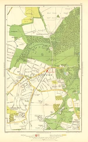
Ajouter au panierEtat : Good. CHINGFORD. Woodford Wells Epping Forest Sewardstonebury Suffield Hatch 1937 map. Colour vintage street atlas map; The Geographia map company (1937). 30.5 x 18.5cm, 12 x 7.25 inches. Condition: Good. There is another map printed on the reverse side of this map. The paper is thick, and the map on the reverse side does not show through the paper. Map section #20 This map is one section from a 1937 Street Atlas of Greater London. This section of the map depicts the following suburbs in 1937: Chingford,Chingford Hatch,Sewardstonebury,Suffield Hatch The maps in this series show London during the rapid interwar suburban expansion. Many areas shown in the outer suburbs as undeveloped land on these maps are now built up. Less frequently, some maps indicate housing developments proposed in 1937 but which were never built on land which is still undeveloped, or which has been built up according to a different street layout from that shown. The inner London maps in this series show London before the damage inflicted by the Blitz during World War 2 and the subsequent redevelopment of the 1950's and 1960's. These maps predate the construction of any motorways (the M1 sections into London having opened between 1966-1977), many major roads, and other post-war urban traffic schemes. The elevated sections of many major roads were constructed after the second world war; for example, the maps predate the construction of the Westway and elevated sections of the A4; the Western Avenue is shown on map sections #142 & #143 as proposed or under construction to the west of Northolt Aerodrome. The London docklands are shown at the height of their scale and glory, a network of large docks and railway lines. The last dock to be built had been completed in 1921. The prosperity of the docklands continued until the advent of containerisation 1960's, whereafter they remained derelict until redevelopment commenced in the early 1980's, centred around the area now known as Canary Wharf These maps show a number of now disappeared features, such as aerodromes which have since disappeared or changed their use, the Brooklands motor racing circuit (shown on map section #157, 2 years before it hosted its last race in 1939), and railways which are now disused. LHR is shown on map section #150 as the modest "Great West Aerodrome"; the original Heathrow Hall is also depicted on this map. The airport at that time was used for aircraft assembly and testing, with Croydon Airport (shown on map sections #163 and #164) being the main airport used for commercial flights.
-
Chingford,Chingford Hatch,Sewardstonebury,Suffield Hatch
Date d'édition : 1923
Vendeur : Antiqua Print Gallery, London, Royaume-Uni
Évaluation du vendeur 3 sur 5 étoiles
Carte
EUR 22,62
Autre deviseEUR 12,71 expédition depuis Royaume-Uni vers FranceQuantité disponible : 2 disponible(s)
Ajouter au panierEtat : Good. CHINGFORD.Woodford Wells,Epping Forest,Sewardstonebury,Suffield Hatch 1923 map. Colour vintage street atlas map; The Geographia map company (1923). 33.0 x 19.5cm, 13 x 7.75 inches. Condition: Good. Verso text quite apparent; Blemish in margin. There are images and/or text printed on the reverse side of this map. The following rail & underground stations are marked on the map: Chingford. Notable buildings, features and public spaces marked on the map include: Epping Forest, West Essex Golf Course.
