
Montant total (1 article articles) :
Destination de la commande :

cities pittsburgh allegheny city cincinnati de colton g w c b (2 résultats)
Commentaires
Passer aux résultats principaux de la recherche
Filtres de recherche
Type d'article
- Tous les types de produits
- Livres (1)
- Magazines & Périodiques (Aucun autre résultat ne correspond ŕ ces critčres)
- Bandes dessinées (Aucun autre résultat ne correspond ŕ ces critčres)
- Partitions de musique (Aucun autre résultat ne correspond ŕ ces critčres)
- Art, Affiches et Gravures (Aucun autre résultat ne correspond ŕ ces critčres)
- Photographies (Aucun autre résultat ne correspond ŕ ces critčres)
- Cartes (1)
- Manuscrits & Papiers anciens (Aucun autre résultat ne correspond ŕ ces critčres)
Etat En savoir plus
- Neuf (Aucun autre résultat ne correspond ŕ ces critčres)
- Comme neuf, Trčs bon ou Bon (Aucun autre résultat ne correspond ŕ ces critčres)
- Assez bon ou satisfaisant (Aucun autre résultat ne correspond ŕ ces critčres)
- Moyen ou mauvais (Aucun autre résultat ne correspond ŕ ces critčres)
- Conformément ŕ la description (2)
Reliure
- Toutes
- Couverture rigide (Aucun autre résultat ne correspond ŕ ces critčres)
- Couverture souple (Aucun autre résultat ne correspond ŕ ces critčres)
Particularités
- Ed. originale (Aucun autre résultat ne correspond ŕ ces critčres)
- Signé (Aucun autre résultat ne correspond ŕ ces critčres)
- Jaquette (Aucun autre résultat ne correspond ŕ ces critčres)
- Avec images (2)
- Sans impressions ŕ la demande (2)
Langue (1)
Prix
- Tous les prix
- Moins de EUR 20 (Aucun autre résultat ne correspond ŕ ces critčres)
- EUR 20 ŕ EUR 45
- Plus de EUR 45
Livraison gratuite
- Livraison gratuite ŕ destination de France (Aucun autre résultat ne correspond ŕ ces critčres)
Pays
Evaluation du vendeur
-
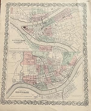
The Cities of Pittsburgh and Allegheny The City of CINCINNATI, OHIO with parts of adjacent boroughs, Pennsylvania:
Edité par Colton, J. H., New York, 1855
Vendeur : mediumraremaps.com, Franklin, TN, Etats-Unis
Évaluation du vendeur 4 sur 5 étoiles

Carte
EUR 35,12
Autre deviseEUR 7,67 expédition depuis Etats-Unis vers FranceQuantité disponible : 1 disponible(s)
Ajouter au panier12 1/2 X 15 3/4 INCHES. This map page has two maps. The upper map is of Pitts burgh and Allegheny. It is accopnyied by the lower half map of Cincinnati. Most important is the connection between the two cities; both were mated physically and economically by the Ohio River. These are very nice maps suitable for framing. it was hand colored in 1855 when the map was produced. Very good with a couple of repaired tears using archival mending tape.
-

The Cities of Pittsburgh and Allegheny & The City of Cincinnati, Ohio
Date d'édition : 1873
Vendeur : Art Source International Inc., Boulder, CO, Etats-Unis
Évaluation du vendeur 2 sur 5 étoiles

EUR 87,80
Autre deviseEUR 34,10 expédition depuis Etats-Unis vers FranceQuantité disponible : 2 disponible(s)
Ajouter au panierArt Source International is proud to offer this plate from the 1873 edition of Colton's General Atlas. Colton atlases, especially those from the early 1870's, have become increasingly rare. This map has been very well maintained, and its original hand coloring remains quite rich. Two maps show Pittsburgh and Allegheny, Pennsylvania and Cincinnati, Ohio, respectively. This map measures 16 inches by 13 inches.