
Montant total (1 article articles) :
Destination de la commande :

decorative printed maps 15th 18th de skelton (108 rťsultats)
Commentaires
Passer aux rťsultats principaux de la recherche
Filtres de recherche
Type d'article
- Tous les types de produits
- Livres (106)
- Magazines & Pťriodiques (Aucun autre rťsultat ne correspond ŗ ces critŤres)
- Bandes dessinťes (Aucun autre rťsultat ne correspond ŗ ces critŤres)
- Partitions de musique (Aucun autre rťsultat ne correspond ŗ ces critŤres)
- Art, Affiches et Gravures (Aucun autre rťsultat ne correspond ŗ ces critŤres)
- Photographies (Aucun autre rťsultat ne correspond ŗ ces critŤres)
- Cartes (2)
- Manuscrits & Papiers anciens (Aucun autre rťsultat ne correspond ŗ ces critŤres)
Etat En savoir plus
- Neuf (Aucun autre rťsultat ne correspond ŗ ces critŤres)
- Comme neuf, TrŤs bon ou Bon (7)
- Assez bon ou satisfaisant (46)
- Moyen ou mauvais (4)
- Conformťment ŗ la description (51)
Particularitťs
- Ed. originale (23)
- Signť (Aucun autre rťsultat ne correspond ŗ ces critŤres)
- Jaquette (57)
- Avec images (28)
- Sans impressions ŗ la demande (108)
Langue (3)
Livraison gratuite
- Livraison gratuite ŗ destination de France (Aucun autre rťsultat ne correspond ŗ ces critŤres)
Pays
Evaluation du vendeur
-

Decorative Printed Maps of the 15th and 18th Centuries
Editť par Spring Books, 1967
Vendeur : Anybook.com, Lincoln, Royaume-Uni
…valuation du vendeur 5 sur 5 ťtoiles

EUR 5,17
Autre deviseEUR 7,57 expťdition depuis Royaume-Uni vers FranceQuantitť disponible : 1 disponible(s)
Ajouter au panierEtat : Good. This is an ex-library book and may have the usual library/used-book markings inside.This book has hardback covers. In good all round condition. Dust jacket in fair condition. Please note the Image in this listing is a stock photo and may not match the covers of the actual item,1450grams, ISBN:
-
Decorative Printed Maps Of The 15th To 18th Centuries : A Revised Edition of Old Decorative Maps and Charts By A. L. Humphreys with 84 Reproductions
Editť par Staples Press
Vendeur : Kennys Bookstore, Olney, MD, Etats-Unis
…valuation du vendeur 5 sur 5 ťtoiles
EUR 11,91
Autre deviseEUR 2,70 expťdition depuis Etats-Unis vers FranceQuantitť disponible : 1 disponible(s)
Ajouter au panierEtat : Good. 1952. Hardcover. Good copy in good dustwrappers. DW has large tear on front cover. All prints present. Previous owners name to FFEP, remains good. . . . . Books ship from the US and Ireland.
-
Decorative Printed Maps Of The 15th To 18th Centuries : A Revised Edition of Old Decorative Maps and Charts By A. L. Humphreys with 84 Reproductions
Editť par Staples Press, 1952
Vendeur : Kennys Bookshop and Art Galleries Ltd., Galway, GY, Irlande
…valuation du vendeur 5 sur 5 ťtoiles
EUR 11,36
Autre deviseEUR 3 expťdition depuis Irlande vers FranceQuantitť disponible : 1 disponible(s)
Ajouter au panierEtat : Good. 1952. Hardcover. Good copy in good dustwrappers. DW has large tear on front cover. All prints present. Previous owners name to FFEP, remains good. . . . .
-

Decorative Printed Maps of the 15th to 18th Centuries
Editť par Spring Books, 1967
Langue: anglais
Vendeur : D & M Books, PBFA, Mirfield, Royaume-Uni
Membre d'association : PBFA
…valuation du vendeur 4 sur 5 ťtoiles

EUR 8,43
Autre deviseEUR 16,41 expťdition depuis Royaume-Uni vers FranceQuantitť disponible : 1 disponible(s)
Ajouter au panierHardcover. Etat : Very Good. Etat de la jaquette : Very Good. 'Decorative Printed Maps of the 15th to 18th Centuries' by R. A. Skelton. Spring Books 1967 edition. VG in edge rubbed dust jacket.
-
Decorative Printed Maps of the 15th to the 18th Century
Editť par Spring Books, London, 1966
Vendeur : Bemrose Books, Otley, Royaume-Uni
…valuation du vendeur 5 sur 5 ťtoiles
EUR 10,02
Autre deviseEUR 9,15 expťdition depuis Royaume-Uni vers FranceQuantitť disponible : 1 disponible(s)
Ajouter au panierHardcover. Etat : Good. Etat de la jaquette : Good. No internal markings; unclipped D/J is worn at edges and protected with removable premium grade clear wrap.
-
Decorative Printed Maps of the 15th to 18th Centuries
Editť par Spring Books, 1967
Vendeur : Anybook.com, Lincoln, Royaume-Uni
…valuation du vendeur 5 sur 5 ťtoiles
EUR 11,06
Autre deviseEUR 8,03 expťdition depuis Royaume-Uni vers FranceQuantitť disponible : 1 disponible(s)
Ajouter au panierEtat : Fair. This is an ex-library book and may have the usual library/used-book markings inside.This book has hardback covers. Clean from markings. In fair condition, suitable as a study copy. Dust jacket in poor condition. Please note the Image in this listing is a stock photo and may not match the covers of the actual item,1500grams, ISBN:
-
DECORATIVE PRINTED MAPS Of The 15th To 18th Centuries.
Editť par London Staples Press A REVISED EDITION of Old Decorative Maps And Charts by A L Humphreys, 1952
Langue: anglais
Vendeur : Handsworth Books PBFA, Woodford Green, Royaume-Uni
Membre d'association : PBFA
…valuation du vendeur 4 sur 5 ťtoiles
EUR 14,73
Autre deviseEUR 15,95 expťdition depuis Royaume-Uni vers FranceQuantitť disponible : 1 disponible(s)
Ajouter au panierHardcover. Etat : Very Good. 4to, vii, 80pp, with 84 reproductions in Colour and Black-and-White, Red Cloth Gilt in Very Good condition. No Dust Jacket.
-

Decorative printed Maps of the 15th to 18th Centuries
Editť par London, Spring Books, 1967
Vendeur : Barksdale Books, Almere, Pays-Bas
…valuation du vendeur 5 sur 5 ťtoiles
EUR 10
Autre deviseEUR 11,95 expťdition depuis Pays-Bas vers FranceQuantitť disponible : 1 disponible(s)
Ajouter au panierEtat : Good. 3rd Edition. Gilt cloth, dust jacket, 80p. + 84 plates (some in colour).; Small tears dust jacket repaired.
-
Decorative Printed Maps of the 15th to 18th Centuries
Editť par Spring Books, 1966
Vendeur : Buli-Antiquariat, Gumtow, Allemagne
…valuation du vendeur 5 sur 5 ťtoiles
EUR 10
Autre deviseEUR 13 expťdition depuis Allemagne vers FranceQuantitť disponible : 1 disponible(s)
Ajouter au panierOLeinen / Hardcover m. OU. A revised edition of "Old decorative maps and charts" by A. L. Humphreys. This handsomely illustrated book provides a survey of maps printed from copper plates or wood-blocks between the 15th and 18th centuries., 80 Seiten Text und 84 Seiten Abbildungen, GUTER ZUSTAND, GOOD, BON ETAT. Text englisch Size: 28 x 22 Cm. 1600 Gr.
-
Decorative Printed Maps of the 15th to 18th Centuries
Editť par Staples Press Limited, London, 1952
Vendeur : CHARLES BOSSOM, Ely, CAMBS, Royaume-Uni
…valuation du vendeur 5 sur 5 ťtoiles
Edition originale
EUR 6,48
Autre deviseEUR 17,15 expťdition depuis Royaume-Uni vers FranceQuantitť disponible : 1 disponible(s)
Ajouter au panierHard Cover. Etat : Very Good. Etat de la jaquette : No DJ. First Edition. Heavy book but no extra postage will be asked for within the UK, (overseas at cost.) Red cloth with gilt titling on spine. Gilt illustrated on upper boards. Slightly bowed boards. Rubbed edges. No ownership marks. vii, 80pp, 84 full page colour & b/w plates clean and tight. Size: 4to.
-
DECORATIVE PRINTED MAPS OF THE 15th to 18th CENTURIES.
Editť par Spring Books, London, 1967
Vendeur : CHARLES BOSSOM, Ely, CAMBS, Royaume-Uni
…valuation du vendeur 5 sur 5 ťtoiles
Edition originale
EUR 7,07
Autre deviseEUR 17,15 expťdition depuis Royaume-Uni vers FranceQuantitť disponible : 1 disponible(s)
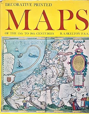
Ajouter au panierHard Cover. Etat : Very Good. Etat de la jaquette : Good. 86 b/w and Colour Plates (illustrateur). Third Impression. This is a very heavy book but it will be supplied at the default p & p to addresses within the UK. Revised edition. Dust jacket is in a protective sleeve, closed tears and edge wear. Blue cloth with bright gilt lettering to spine. Slightly rubbed to lower edge. No inscription. 80 pages plus plates clean and tight. This handsomelly illustrated book provides a survey of maps printed from copper plates or wood blocks between the 15th and 18th centuries. The 86 reproductions, 12 in full colour, serves as a specimen book to illustrate the development of map-design and decoration. The introduction describes the techniques used for engraving & printing, the history of the map trade, the development of symbols, lettering, decoration and colouring of maps, some problems in the dating and study of engraved maps, their mortality, and the history of map collecting.
-
EUR 14,95
Autre deviseEUR 9,95 expťdition depuis Irlande vers FranceQuantitť disponible : 1 disponible(s)
Ajouter au panierReprint. Very good copy in the original gilt-blocked cloth. Spine bands and panel edges somewhat rubbed and dust-toned as with age. Remains quite well-preserved overall; tight, bright, clean and strong. Physical description; viii, 80p, 84 leaves of plates (some col) : facsim. maps. Notes; This ed. originally published, London : Staples Press, 1952. A revised ed. of 'Old decorative maps and charts' by A.L. Humphreys, published, London : Halton and Truscott-Smith, 1926. Subject; Maps, Early Facsimiles. 2 Kg.
-
EUR 14,95
Autre deviseEUR 9,95 expťdition depuis Irlande vers FranceQuantitť disponible : 1 disponible(s)
Ajouter au panierSecond Edition. Very good copy in the original gilt-blocked cloth. Spine bands and panel edges somewhat rubbed and dust-toned as with age. Remains quite well-preserved overall; tight, bright, clean and strong. Physical description: 80p. ; 84 plates,ill.,29cm. Notes: Includes bibliographic notes and index. Edition: revised edition of old decorative maps and charts. Subject: History- Cartography. Facsimiles. Early maps, charts, diagrams. Other names: Humphreys, Arthur Lee (1865-1946) Genre: Bibliography, Illustrated. 1 Kg.
-
Decorative Printed Maps of the 15th to 18th Centuries. Revised edition of "Old Decorative Maps and Charts".
Editť par Staples Press, 1952., 1952
Vendeur : R.G. Watkins Books and Prints, Ilminster, SOMER, Royaume-Uni
…valuation du vendeur 4 sur 5 ťtoiles
EUR 11,78
Autre deviseEUR 13,72 expťdition depuis Royaume-Uni vers FranceQuantitť disponible : 1 disponible(s)
Ajouter au panierHardcover. Etat : Very good. No Jacket. 84 plates, some colour, index; viii+80pp. 4to orig. cloth, spine faded, some wear on extremities,
-
Decorative Printed Maps of the 15th to 18th Centuries
Editť par London, Spring Books 1965, 1965
Vendeur : Horsham Rare Books, Horsham, Royaume-Uni
Membre d'association : PBFA
…valuation du vendeur 4 sur 5 ťtoiles
EUR 14,13
Autre deviseEUR 11,32 expťdition depuis Royaume-Uni vers FranceQuantitť disponible : 1 disponible(s)
Ajouter au panierReprint of a revised edition of Old Decorative Maps and Charts by A L Humphries. : Very good blue boards with some signs of fading in places, clean and tight, 11.00 x 7.75 inches approx. , well used dustjacket, has been poorly repaired with tape to the outside at one point this has been removed and the tears are now internally repaired, not price clipped, 80 pages followed by 84 colour and mono plates of maps at rear, contents very good tight and clean, some discoloring to closed page edges.
-

Decorative Printed Maps of the 15th to 18th Centuries: A Revised Edition of Old Decorative Maps and Charts By A. L. Humphreys
Editť par Staples Press, London; New York, 1952
Vendeur : Besleys Books PBFA, Diss, Royaume-Uni
Membre d'association : PBFA
…valuation du vendeur 5 sur 5 ťtoiles
Edition originale
EUR 15,31
Autre deviseEUR 10,29 expťdition depuis Royaume-Uni vers FranceQuantitť disponible : 1 disponible(s)
Ajouter au panierHard Cover. Etat : Very Good. Skelton, R. A. (illustrateur). 1st Edition. Hardback, red cloth, gilt titles to spine. 32cm x 25.5cm. 80pp + 84 plates. 1st edition 1952. Spine a little faded, slight wear to extremities. Clean inside. A pleasing copy. A heavy book, additional postage may be required for orders outside the UK. (q13).
-
DECORATIVE PRINTED MAPS of the 15th To 18th Centuries
Editť par Spring Books, London, 1965
Langue: anglais
Vendeur : THOMAS RARE BOOKS, Yaxley, SUFFOLK, Royaume-Uni
…valuation du vendeur 4 sur 5 ťtoiles
EUR 21,20
Autre deviseEUR 18,30 expťdition depuis Royaume-Uni vers FranceQuantitť disponible : 1 disponible(s)
Ajouter au panierHardback. Etat : Fine. Etat de la jaquette : V G rubbed. re-issue. 80pp, 84 plates. d.j. a trifle rubbed.
-
Decorative Printed Maps of the 15th to 18th. Centuries. Second Impression.
Editť par Spring Books, London, 1966
Vendeur : Emile Kerssemakers ILAB, Heerlen, Pays-Bas
Membre d'association : ILAB NVVA
…valuation du vendeur 5 sur 5 ťtoiles
EUR 15
Autre deviseEUR 11,80 expťdition depuis Pays-Bas vers FranceQuantitť disponible : 1 disponible(s)
Ajouter au panierOrig. blue boards, gilt. With dustjacket. viii,80 pp. and 84 plates/ maps, some in col.; 29 cm. - (name on endpaper, d.j. sl. dam. and sl. faded, although very good). A revised edition of Old Decorative Maps and Charts by A.L. Humphreys. With eighty-four reproductions and a new text. 1700g.
-
Decorative Printed Maps of the 15th to 18th Centuries.
Editť par London, Spring Books. 1967, 1967
Vendeur : Antiquariaat Schot, Hendrik-Ido-Ambacht, Pays-Bas
…valuation du vendeur 5 sur 5 ťtoiles
EUR 13,80
Autre deviseEUR 13 expťdition depuis Pays-Bas vers FranceQuantitť disponible : 1 disponible(s)
Ajouter au panierOriginal publishers blue paper-covered boards, gilt title spine, pictorial dustjacket, third impression of revised edition [1952 & 1965 & 1966], 4to: [viij], 80pp., [168]pp., 84 plates, bibliographical notes, general bibliography, nominal & subject indexes. Fine copy.
-
Decorative Printed Maps of the 15th to 18th Centuries. A revised edition of Old Decorative Maps and Charts by A. L. Humphreys.
Editť par Staples Press, London, first edition, 1952, 1952
Vendeur : Wykeham Books, LONDON, Royaume-Uni
Membre d'association : ABA ILAB PBFA
…valuation du vendeur 4 sur 5 ťtoiles
Edition originale
EUR 11,78
Autre deviseEUR 16,01 expťdition depuis Royaume-Uni vers FranceQuantitť disponible : 1 disponible(s)
Ajouter au panierCloth, gilt cover device, large 4to, vii, 80 pp, 84 plates (chiefly maps, 12 in colour) This book "provides a survey of maps printed from copper plates or wood-blocks between the 15th and 18th centuries. In these four centuries, from the birth of map-printing to the eve of scientific cartography, the printed map was the chief vehicle of popular geographical ideas. It was also, and still is, a source of visual pleasure. The early map-maker's deficiencies of knowledge and technique encouraged him to exercise his sense of fitness in design and his ingenuity in the decoration of his work. The design of his maps was controlled no less by the tools and processes used in engraving and printing them than by the public for whom they were made and by the commercial channels through which they were circulated. These topics have received little notice in most gencral works on cartography and they are given special attention in this volume. The 86 reproductions, 12 of which are in full colour, serve as a specimen book to illustrate the development of map-design and decoration. Of these reproductions 22 are new to this work, the remainder having been published in A. L. Humphreys' Old Decorative Maps and Charts (1926). The text, by Mr R. A. Skelton, is entirely new and comprises an Introduction, a General Bibliography, and eight chapters dealing with the successive phases or national schools of map-making. The Introduction describes the techniques used for engraving and printing maps, the history of the map-trade, the development of the symbols, lettering, decoration and colouring of maps, some problems in the dating and study of engraved maps, their mortality, and the history of map-collecting. Each of the chapters that follow is associated with one group of plates and includes a short essay on it, a select bibliography, and notes on each of the plates. Although geographically the scope of the work is world-wide, in the text and the choice of new illustrations special prominence has been given to English maps, since these may be expected to have particular interest for readers in the English-speaking world." from the blurb. Covers scuffed and withsome marks, slightly worn at extremities, contents Good.
-
Decorative Printed Maps of the 15th to 18th Centuries. A revised edition of Old Decorative Maps and Charts by A. L. Humphreys.
Editť par Staples Press, London, first edition, 1952, 1952
Vendeur : Wykeham Books, LONDON, Royaume-Uni
Membre d'association : ABA ILAB PBFA
…valuation du vendeur 4 sur 5 ťtoiles
Edition originale
EUR 11,78
Autre deviseEUR 16,01 expťdition depuis Royaume-Uni vers FranceQuantitť disponible : 1 disponible(s)
Ajouter au panierCloth, gilt cover device, large 4to, vii, 80 pp, 84 plates (chiefly maps, 12 in colour) This book "provides a survey of maps printed from copper plates or wood-blocks between the 15th and 18th centuries. In these four centuries, from the birth of map-printing to the eve of scientific cartography, the printed map was the chief vehicle of popular geographical ideas. It was also, and still is, a source of visual pleasure. The early map-maker's deficiencies of knowledge and technique encouraged him to exercise his sense of fitness in design and his ingenuity in the decoration of his work. The design of his maps was controlled no less by the tools and processes used in engraving and printing them than by the public for whom they were made and by the commercial channels through which they were circulated. These topics have received little notice in most gencral works on cartography and they are given special attention in this volume. The 86 reproductions, 12 of which are in full colour, serve as a specimen book to illustrate the development of map-design and decoration. Of these reproductions 22 are new to this work, the remainder having been published in A. L. Humphreys' Old Decorative Maps and Charts (1926). The text, by Mr R. A. Skelton, is entirely new and comprises an Introduction, a General Bibliography, and eight chapters dealing with the successive phases or national schools of map-making. The Introduction describes the techniques used for engraving and printing maps, the history of the map-trade, the development of the symbols, lettering, decoration and colouring of maps, some problems in the dating and study of engraved maps, their mortality, and the history of map-collecting. Each of the chapters that follow is associated with one group of plates and includes a short essay on it, a select bibliography, and notes on each of the plates. Although geographically the scope of the work is world-wide, in the text and the choice of new illustrations special prominence has been given to English maps, since these may be expected to have particular interest for readers in the English-speaking world." from the blurb. Name on front pastedown endpaper, covers rubbed and slightly marked, colour variation on rear board, otherwise Good.
-
Decorative Printed Maps of the 15th to 18th Centuries.
Editť par Spring Books, London, 1967 reprint of 1965 third impression, 1967
Vendeur : Wykeham Books, LONDON, Royaume-Uni
Membre d'association : ABA ILAB PBFA
…valuation du vendeur 3 sur 5 ťtoiles

EUR 11,78
Autre deviseEUR 16,01 expťdition depuis Royaume-Uni vers FranceQuantitť disponible : 1 disponible(s)
Ajouter au panierCloth, large 4to, vii, 80 pp, 84 plates (chiefly maps, 12 in colour) This book "provides a survey of maps printed from copper plates or wood-blocks between the 15th and 18th centuries. In these four centuries, from the birth of map-printing to the eve of scientific cartography, the printed map was the chief vehicle of popular geographical ideas. It was also, and still is, a source of visual pleasure. The early map-maker's deficiencies of knowledge and technique encouraged him to exercise his sense of fitness in design and his ingenuity in the decoration of his work. The design of his maps was controlled no less by the tools and processes used in engraving and printing them than by the public for whom they were made and by the commercial channels through which they were circulated. These topics have received little notice in most gencral works on cartography and they are given special attention in this volume. The 86 reproductions, 12 of which are in full colour, serve as a specimen book to illustrate the development of map-design and decoration. Of these reproductions 22 are new to this work, the remainder having been published in A. L. Humphreys' Old Decorative Maps and Charts (1926). The text, by Mr R. A. Skelton, is entirely new and comprises an Introduction, a General Bibliography, and eight chapters dealing with the successive phases or national schools of map-making. The Introduction describes the techniques used for engraving and printing maps, the history of the map-trade, the development of the symbols, lettering, decoration and colouring of maps, some problems in the dating and study of engraved maps, their mortality, and the history of map-collecting. Each of the chapters that follow is associated with one group of plates and includes a short essay on it, a select bibliography, and notes on each of the plates. Although geographically the scope of the work is world-wide, in the text and the choice of new illustrations special prominence has been given to English maps, since these may be expected to have particular interest for readers in the English-speaking world." from the blurb. Good in a used and chipped dustwrapper, old tape-repair at top edge.
-
DECORATIVE PRINTED MAPS OF THE 15TH TO 18TH CENTURIES
Editť par Staples Press, London and NY, 1952
Langue: anglais
Vendeur : Terra Firma Books, San Diego, CA, Etats-Unis
…valuation du vendeur 5 sur 5 ťtoiles
EUR 13,24
Autre deviseEUR 29,15 expťdition depuis Etats-Unis vers FranceQuantitť disponible : 1 disponible(s)
Ajouter au panierHardcover. Etat : Good. FIRST Edition!vii+80pp + 84 map reproductions. Original binding tight but shows wear; name in front otherwise Clean.
-
Decorative printed maps of the 15th to 18th centuries : A rev. ed. of Old decorative maps and charts / by A.L. Humphreys. With eighty-four reproductions and a new text by R.A. Skelton
Editť par London : Spring Books, 1967
EUR 18
Autre deviseEUR 9,95 expťdition depuis Irlande vers FranceQuantitť disponible : 1 disponible(s)
Ajouter au panierThird Edition. Near fine copy in the original gilt-blocked cloth. Panel edges very slightly dust-toned as with age. Corners sharp with an overall tight, bright and clean impression. Physical description; viii, 80 p : 84 plates (Chiefly maps, 12 col.) Subject; Maps, Early Facsimiles. 2 Kg.
-

Decorative Printed Maps of the 15th to 18th Centuries
Editť par Spring Books, 1966
Vendeur : H4o Books, Market Rasen, LINCS, Royaume-Uni
…valuation du vendeur 4 sur 5 ťtoiles
EUR 11,78
Autre deviseEUR 16,58 expťdition depuis Royaume-Uni vers FranceQuantitť disponible : 1 disponible(s)
Ajouter au panierHardcover (Original Cloth). Etat : Very Good. Etat de la jaquette : Good. Humphreys, A. L. (illustrateur). 2nd impression of the 1965 revised edition. Jacket not price clipped. One closed tear to front tail. Slightly spotted, as are the page edges. With 84 reproductions. Item Type: Book. Illustrator: Humphreys, A. L. Category: Reference; Please contact H4o Books if you require images or further information. Inventory No: 015558.
-
Decorative Printed Maps of the 15th to 18th Centuries. A revised edition of Old Decorative Maps and Charts by A. L. Humphreys.
Editť par Staples Press, London, first edition, 1952, 1952
Vendeur : Wykeham Books, LONDON, Royaume-Uni
Membre d'association : ABA ILAB PBFA
…valuation du vendeur 4 sur 5 ťtoiles
Edition originale
EUR 12,96
Autre deviseEUR 16,01 expťdition depuis Royaume-Uni vers FranceQuantitť disponible : 1 disponible(s)
Ajouter au panierCloth, gilt cover device, large 4to, vii, 80 pp, 84 plates (chiefly maps, 12 in colour) This book "provides a survey of maps printed from copper plates or wood-blocks between the 15th and 18th centuries. In these four centuries, from the birth of map-printing to the eve of scientific cartography, the printed map was the chief vehicle of popular geographical ideas. It was also, and still is, a source of visual pleasure. The early map-maker's deficiencies of knowledge and technique encouraged him to exercise his sense of fitness in design and his ingenuity in the decoration of his work. The design of his maps was controlled no less by the tools and processes used in engraving and printing them than by the public for whom they were made and by the commercial channels through which they were circulated. These topics have received little notice in most gencral works on cartography and they are given special attention in this volume. The 86 reproductions, 12 of which are in full colour, serve as a specimen book to illustrate the development of map-design and decoration. Of these reproductions 22 are new to this work, the remainder having been published in A. L. Humphreys' Old Decorative Maps and Charts (1926). The text, by Mr R. A. Skelton, is entirely new and comprises an Introduction, a General Bibliography, and eight chapters dealing with the successive phases or national schools of map-making. The Introduction describes the techniques used for engraving and printing maps, the history of the map-trade, the development of the symbols, lettering, decoration and colouring of maps, some problems in the dating and study of engraved maps, their mortality, and the history of map-collecting. Each of the chapters that follow is associated with one group of plates and includes a short essay on it, a select bibliography, and notes on each of the plates. Although geographically the scope of the work is world-wide, in the text and the choice of new illustrations special prominence has been given to English maps, since these may be expected to have particular interest for readers in the English-speaking world." from the blurb. Boards rubbed and scuffed, large grease-stains to endpapers and several margins (though not affecting text)., name on front free endpaper.
-
Decorative Printed Maps of the 15th to 18th Centuries.
Editť par London, Spring Books. 1966, 1966
Vendeur : Antiquariaat Schot, Hendrik-Ido-Ambacht, Pays-Bas
…valuation du vendeur 5 sur 5 ťtoiles
EUR 17,25
Autre deviseEUR 13 expťdition depuis Pays-Bas vers FranceQuantitť disponible : 2 disponible(s)
Ajouter au panierOriginal publisher's blue paper-covered boards, gilt title spine, pictorial dustjacket, second printing [1952 & 1965], 4to: [viij], 80pp., [168]pp., 84 page-large plates, footnotes & references, general bibliography, nominal & subject indexes. Very fine copy.
-
EUR 9,41
Autre deviseEUR 13,72 expťdition depuis Royaume-Uni vers FranceQuantitť disponible : 1 disponible(s)
Ajouter au panierHardcover. Etat : Very Good. Etat de la jaquette : Good. No damage or markings to pages and only very light wear to cover. Dustjacket in good condition with slight scuffing at edges and short tears at both ends of the spine. 1952 hardback. The photo is of the actual book you will receive. Fast dispatch from UK seller.
-
![Image du vendeur pour Decorative Printed Maps of the 15th to 18th centuries a revised edition of 'Old Decorative Maps and Charts' by A.L. Humphreys. with 84 reproductions [12 in colour] and a new text by R.A. Skelton mis en vente par McLaren Books Ltd., ABA(associate), PBFA](https://pictures.abebooks.com/inventory/md/md30936211002.jpg)
Decorative Printed Maps of the 15th to 18th centuries a revised edition of 'Old Decorative Maps and Charts' by A.L. Humphreys. with 84 reproductions [12 in colour] and a new text by R.A. Skelton
Editť par London Staples Press, 1952
Vendeur : McLaren Books Ltd., ABA(associate), PBFA, Largs, Royaume-Uni
Membre d'association : ABA ILAB PBFA
…valuation du vendeur 5 sur 5 ťtoiles
EUR 17,67
Autre deviseEUR 13,66 expťdition depuis Royaume-Uni vers FranceQuantitť disponible : 1 disponible(s)
Ajouter au panierlarge format hardback [32x25cm]. 87 pages + maps. good clean condition internally but the binding is a bit rubbed and worn around the spine. from the library of the Cruising Association. [heavy book that may require extra shipping charges for overseas orders. please see our storefront page for shipping information].
-

Decorative Printed Maps Of The 15th To 18th Centuries : A Revised Edition of Old Decorative Maps and Charts By A. L. Humphreys with 84 Reproductions
Editť par Staples Press, London, 1952
Vendeur : Lazy Letters Books, Market Rasen, Royaume-Uni
…valuation du vendeur 5 sur 5 ťtoiles
EUR 17,67
Autre deviseEUR 13,55 expťdition depuis Royaume-Uni vers FranceQuantitť disponible : 1 disponible(s)
Ajouter au panierCloth. Etat : Good. No Jacket. Lightly edge-rubbed boards, more so on the corners. Some splitting to head of spine. Library stamps and labels. Minimal wear to pages. Plates in black & white and colour.
