Montant total (1 article articles) :
Destination de la commande :

eastern states de bartholomew john (17 résultats)
Commentaires
Passer aux résultats principaux de la recherche
Filtres de recherche
Type d'article
- Tous les types de produits
- Livres (11)
- Magazines & Périodiques (Aucun autre résultat ne correspond ŕ ces critčres)
- Bandes dessinées (Aucun autre résultat ne correspond ŕ ces critčres)
- Partitions de musique (Aucun autre résultat ne correspond ŕ ces critčres)
- Art, Affiches et Gravures (Aucun autre résultat ne correspond ŕ ces critčres)
- Photographies (Aucun autre résultat ne correspond ŕ ces critčres)
- Cartes (6)
- Manuscrits & Papiers anciens (Aucun autre résultat ne correspond ŕ ces critčres)
Etat En savoir plus
- Neuf (Aucun autre résultat ne correspond ŕ ces critčres)
- Comme neuf, Trčs bon ou Bon (Aucun autre résultat ne correspond ŕ ces critčres)
- Assez bon ou satisfaisant (7)
- Moyen ou mauvais (Aucun autre résultat ne correspond ŕ ces critčres)
- Conformément ŕ la description (10)
Reliure
- Toutes
- Couverture rigide (Aucun autre résultat ne correspond ŕ ces critčres)
- Couverture souple (1)
Particularités
- Ed. originale (1)
- Signé (Aucun autre résultat ne correspond ŕ ces critčres)
- Jaquette (Aucun autre résultat ne correspond ŕ ces critčres)
- Avec images (17)
- Sans impressions ŕ la demande (17)
Langue (1)
Prix
- Tous les prix
- Moins de EUR 20
- EUR 20 ŕ EUR 45
- Plus de EUR 45 (Aucun autre résultat ne correspond ŕ ces critčres)
Livraison gratuite
- Livraison gratuite ŕ destination de France (Aucun autre résultat ne correspond ŕ ces critčres)
Pays
Evaluation du vendeur
-
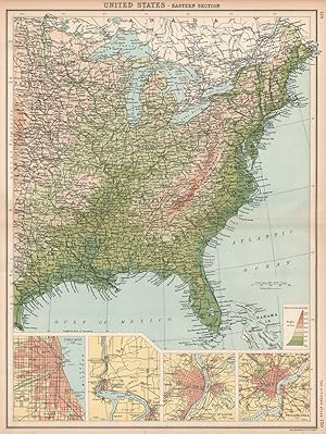
United States-Eastern Section; Inset maps of Environs of Chicago; Canada; Environs of Saint Louis; Environs of Philadelphia
Date d'édition : 1901
Vendeur : Antiqua Print Gallery, London, Royaume-Uni
Évaluation du vendeur 3 sur 5 étoiles

Carte
EUR 7,08
Autre deviseEUR 12,60 expédition depuis Royaume-Uni vers FranceQuantité disponible : 7 disponible(s)
Ajouter au panierEtat : Good. USA EAST. Relief. Inset Chicago Niagara Falls Saint Louis Philadelphia 1901 map. Antique colour map; John Bartholomew (1901). 44.0 x 33.5cm, 17.5 x 13 inches; this is a folding map. Condition: Good. There is nothing printed on the reverse side, which is plain.
-
United States-Eastern Section; Inset maps of Chicago; Niagara Falls; St. Louis; Philadelphia
Date d'édition : 1912
Vendeur : Antiqua Print Gallery, London, Royaume-Uni
Évaluation du vendeur 3 sur 5 étoiles
Carte
EUR 7,67
Autre deviseEUR 12,60 expédition depuis Royaume-Uni vers FranceQuantité disponible : 3 disponible(s)
Ajouter au panierEtat : Good. USA EAST. Relief. Inset Chicago Niagara Falls Saint Louis Philadelphia 1912 map. Antique colour atlas map; John Bartholomew & Co., Edin. (1912). 44.5 x 33.0cm, 17.5 x 13 inches; this is a folding map. Condition: Good. There is nothing printed on the reverse side, which is plain.
-

United States Eastern Division
Vendeur : Antiqua Print Gallery, London, Royaume-Uni
Évaluation du vendeur 3 sur 5 étoiles
EUR 7,67
Autre deviseEUR 12,60 expédition depuis Royaume-Uni vers FranceQuantité disponible : 2 disponible(s)
Ajouter au panier -

United States Eastern Division
Vendeur : Antiqua Print Gallery, London, Royaume-Uni
Évaluation du vendeur 3 sur 5 étoiles
EUR 7,67
Autre deviseEUR 12,60 expédition depuis Royaume-Uni vers FranceQuantité disponible : 3 disponible(s)
Ajouter au panier -
United States Eastern section
Vendeur : Antiqua Print Gallery, London, Royaume-Uni
Évaluation du vendeur 3 sur 5 étoiles
EUR 8,26
Autre deviseEUR 12,60 expédition depuis Royaume-Uni vers FranceQuantité disponible : 3 disponible(s)
Ajouter au panier -
United States North-Eastern division Inset map of New York
Vendeur : Antiqua Print Gallery, London, Royaume-Uni
Évaluation du vendeur 3 sur 5 étoiles
EUR 8,26
Autre deviseEUR 12,60 expédition depuis Royaume-Uni vers FranceQuantité disponible : 2 disponible(s)
Ajouter au panier -

Eastern Middle States United States
Vendeur : Antiqua Print Gallery, London, Royaume-Uni
Évaluation du vendeur 3 sur 5 étoiles
EUR 9,44
Autre deviseEUR 12,60 expédition depuis Royaume-Uni vers FranceQuantité disponible : 3 disponible(s)
Ajouter au panier -

Eastern Middle States United States
Vendeur : Antiqua Print Gallery, London, Royaume-Uni
Évaluation du vendeur 3 sur 5 étoiles
EUR 9,44
Autre deviseEUR 12,60 expédition depuis Royaume-Uni vers FranceQuantité disponible : 1 disponible(s)
Ajouter au panier -

North - Eastern States - Section 2
Vendeur : Antiqua Print Gallery, London, Royaume-Uni
Évaluation du vendeur 3 sur 5 étoiles
EUR 10,03
Autre deviseEUR 12,60 expédition depuis Royaume-Uni vers FranceQuantité disponible : 3 disponible(s)
Ajouter au panier -
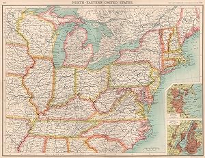
North-Eastern United States; Inset maps of Environs of Boston; Environs of New York
Date d'édition : 1901
Vendeur : Antiqua Print Gallery, London, Royaume-Uni
Évaluation du vendeur 3 sur 5 étoiles
Carte
EUR 10,62
Autre deviseEUR 12,60 expédition depuis Royaume-Uni vers FranceQuantité disponible : 4 disponible(s)
Ajouter au panierEtat : Good. USA NORTH-EAST. United States. Inset Boston & New York. BARTHOLOMEW 1901 map. Antique colour map; John Bartholomew (1901). 33.5 x 43.5cm, 13.25 x 17.25 inches; this is a folding map. Condition: Good. There is nothing printed on the reverse side, which is plain.
-
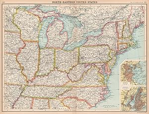
North-Eastern United States; Inset maps of Environs of Boston; Environs of New York
Date d'édition : 1912
Vendeur : Antiqua Print Gallery, London, Royaume-Uni
Évaluation du vendeur 3 sur 5 étoiles
Carte
EUR 11,80
Autre deviseEUR 12,60 expédition depuis Royaume-Uni vers FranceQuantité disponible : 4 disponible(s)
Ajouter au panierEtat : Good. USA NORTH-EAST. United States. Inset Boston & New York. BARTHOLOMEW 1912 map. Antique colour atlas map; John Bartholomew & Co., Edin. (1912). 34.0 x 44.0cm, 13.25 x 17.25 inches; this is a folding map. Condition: Good. There is nothing printed on the reverse side, which is plain.
-

North - Eastern States - Section 1
Vendeur : Antiqua Print Gallery, London, Royaume-Uni
Évaluation du vendeur 3 sur 5 étoiles
EUR 11,80
Autre deviseEUR 12,60 expédition depuis Royaume-Uni vers FranceQuantité disponible : 1 disponible(s)
Ajouter au panier -
Eastern Provinces of Canada and Northern United States
Vendeur : Antiqua Print Gallery, London, Royaume-Uni
Évaluation du vendeur 3 sur 5 étoiles
EUR 12,98
Autre deviseEUR 12,60 expédition depuis Royaume-Uni vers FranceQuantité disponible : 2 disponible(s)
Ajouter au panier -

Eastern States
Vendeur : Antiqua Print Gallery, London, Royaume-Uni
Évaluation du vendeur 3 sur 5 étoiles
EUR 16,51
Autre deviseEUR 12,60 expédition depuis Royaume-Uni vers FranceQuantité disponible : 1 disponible(s)
Ajouter au panier -
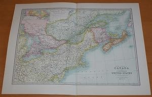
Map of 'Eastern Provinces of Canada and Northern United States' - Sheet 60 disbound from the 1890 'The Library Reference Atlas of the World' with Nova Scotia, New Brunswick, Maine, New York, Pennsylvania, and parts of Quebec and Ontario
Edité par Macmillan and Co., London, 1890
Vendeur : Bailgate Books Ltd, Doncaster, Royaume-Uni
Évaluation du vendeur 5 sur 5 étoiles

Edition originale
EUR 42,47
Autre deviseEUR 9,16 expédition depuis Royaume-Uni vers FranceQuantité disponible : 1 disponible(s)
Ajouter au panierSoftcover. Etat : Very Good. Etat de la jaquette : No Dust Jacket. First Edition. Single disbound coloured map sheet, from John Bartholomew's Library Reference Atlas. Suitable for framing. Approx size 35 x 46cm, vertical centre fold. Map is clean, crisp and bright. Map covers part of Canada and the USA, including Nova Scotia, New Brunswick, Prince Edward Island, Cape Breton Island, parts of Quebec and Ontario, New York, Pennsylvania, Maine, Vermont, New Hampshire, New Jersey, Anticost, Gulf of St Lawrence, Lake Huron, Lake Erie and Lake Ontario. No dust jacket, as published. Quantity Available: 1. Shipped Weight: under 1 kg. Pictures of this item not already displayed here available upon request. Inventory No: 45021014042. All our books are sent by tracked mail.
-
Eastern States
Date d'édition : 1944
Vendeur : Antiqua Print Gallery, London, Royaume-Uni
Évaluation du vendeur 3 sur 5 étoiles
Carte
EUR 21,23
Autre deviseEUR 12,60 expédition depuis Royaume-Uni vers FranceQuantité disponible : 2 disponible(s)
Ajouter au panierEtat : Good. USA EASTERN STATES WV Virginia Pennsylvania MD Delaware New Jersey Ohio 1944 map. Vintage colour atlas map. Scale 1: 2,500,000; John Bartholomew & Son (1944). 34.0 x 45.5cm, 13.5 x 17.75 inches; this is a folding map. Condition: Good. There are images and/or text printed on the reverse side of the picture. In some cases this may be visible on the picture itself or around the margin of the picture. This map was printed in an atlas that was published during the Second World War. Many of the maps show the advance of the Axis powers including the domination of Nazi Germany in continental Europe, and Japan expansion through East Asia and the Pacific. Some of the maps show Vichy France and its territories, Free French territories, Japanese occupied China and Indochina, the partition of Poland.
-

Eastern States
Date d'édition : 1952
Vendeur : Antiqua Print Gallery, London, Royaume-Uni
Évaluation du vendeur 3 sur 5 étoiles
Carte
EUR 23,59
Autre deviseEUR 12,60 expédition depuis Royaume-Uni vers FranceQuantité disponible : 1 disponible(s)
Ajouter au panierEtat : Good. USA EASTERN STATES.WV Virginia Pennsylvania MD Delaware New Jersey Ohio 1952 map. Vintage colour map. Scale 1:2,500,000; John Bartholomew (1952). 34.0 x 45.0cm, 13.25 x 17.5 inches; this is a folding map. Condition: Good. The image shown may have been taken from a different example of this map than that which is offered for sale. The map you will receive is in good condition but there may be minor variations in the condition from that shown in the image. There is another map or maps printed on the reverse side of the picture. The paper is thick, and the printing on the reverse does not show through to the front.